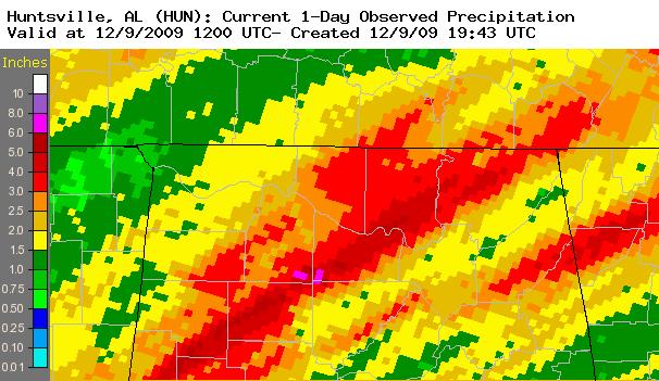
SummaryStrong southwesterly flow from the Gulf of America and a deepening low pressure system moving out of the southern plains and into the Ohio Valley December 8th through 9th, produced flooding rainfall totals to occur across the Tennessee Valley. Most of northern Alabama and portions of Southern Middle Tennessee received between 2 and 4 inches of rainfall by 3 am on Wednesday morning, with a broad area of 4 to 8 inches across Madison, Morgan, southeastern Lawrence, western Jackson and in isolated locations in Dekalb counties. This caused widespread and serious flash flooding and river flooding across Morgan and Madison counties. Some river flooding also occurred at Florence along the Tennessee River. Below are rainfall totals from 12/08/2009 at 6am through 12/09/2009 at 6 am. |
|||||||||
|
|
|||||||||
|
Click here to look at observed rainfall totals for the event. |
|||||||||
|
|
|||||||||
The Flint River at BrownsboroAlthough the initial river level increase was slightly less than changes at Big Nance Creek and Paint Rock River, the Flint River at Brownsboro also reacted very quickly to the heavy rainfall. It was the first river forecast point in the Huntsville Forecast area to reach moderate flood stage. The intial steep rise(about 9 feet) in river stage occurred after 6 pm on Tuesday(December 8th) and climbed above flood stage(17.0 feet) after midnight on Wednesday. It continued to quickly climb to moderate flood stage(19.0 feet) by 6 am. After daybreak the river slowed it's climb briefly. However, a secondary river level increase of 1.83 feet from noon through 6 pm on Wednesday brought the Flint River to a crest of 20.8 feet. This was less than 1.5 feet away from the major flood stage level of 22.0 feet. It's quick rise was followed by a quick drop in river level, as the Flint River at Brownsboro dropped below flood stage (17.0 feet)on Thursday (December 10th) just after daybreak. Significant flooding occurred in the Hampton Cove area in response to the moderate river flooding. Below is a graph of the river stage at this site through noon on December 10th. 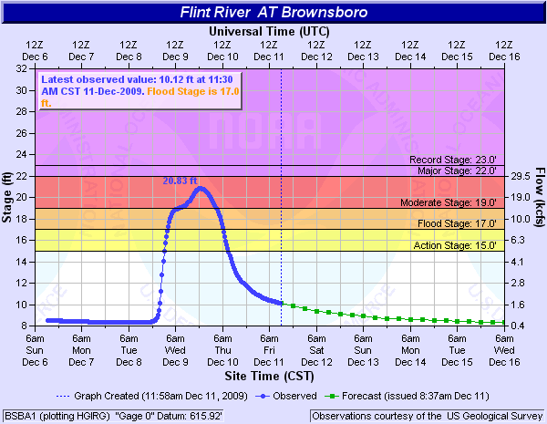
Pictures of Hampton Cove Flooding:Significant flooding of farmlands and the Hampton Cove Golf Course (especially the Robert Trent Jones portion) occurred. Several roads were also closed in the Hampton Cove area including Little Cove road and Cherry Tree Lane. Below are some pictures taken by NWS employees of the flooding in the Hampton Cove area during the late morning and early afternoon period on December 9th. |
|||||||||
|
|||||||||
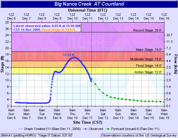
Big Nance Creek at Courtland
The Big Nance Creek at Courtland had an impressive rise of around 10 feet after 6 pm on Tuesday (December 8th). This brought the Big Nance to within two feet of flood stage around midnight on Tuesday. After midnight through the morning hours on Wednesday, Big Nance Creek level leveled off and slightly decreased before a second increase began at this forecast point. |
|||||||||
|
Paint Rock River at Woodville
The largest overall rise in river level occurred at the Paint Rock River at Woodville, where the river stage climbed 10.8 feet in only the course of 13 hours, before cresting at 4:30 am on December 10th at 19.76 feet. This was above the moderate flood stage of 19.0 feet. This river stage site did not see the leveling off in stage height that most of the other flooding points experienced on Tuesday night through Wednesday morning (December 8th and 9th). |
|||||||||
|
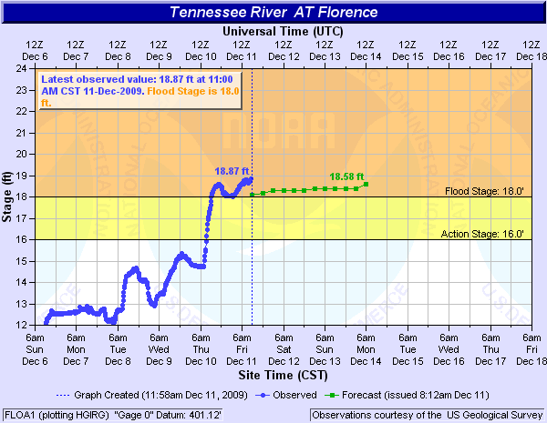
In Addition, Minor Flooding Occurred on the Tennessee River at Florence The Tennessee River at Florence began experiencing minor river flooding Thursday morning (December 10th). Most of the rise in the river stage occurred Thursday morning through the early afternoon hours on Thursday. Campers and visitors at McFarland Park had to be evacuated due to rising waters Thursday afternoon. The river continued to slowly rise and crest at 19.3 feet a few days later on Monday (December 14th). The was close to a river stage of 20.0 feet. At a river stage of 20 feet, Alabama State Highway 20 is flooded at the underpass below U.S. Highways 43 and 72, causing the underpass to be closed.
|
|||||||||
|
Damaging Gradient and Severe Thunderstorm Winds Occurred as Well Also, this system produced severe thunderstorm and gradient wind damage, as some locations gusted to around 70 mph (mainly east of interstate 65). A gust to 69 mph was measured northwest of Owens Crossroads with one of these storms at a Mesonet site. Many reports of downed trees occurred in Jackson, Marshall, and Cullman counties between 11 pm and 2 am.
Click here to see local storm reports from the event.
|
|||||||||


 Local Radar
 Weather Map