|
|
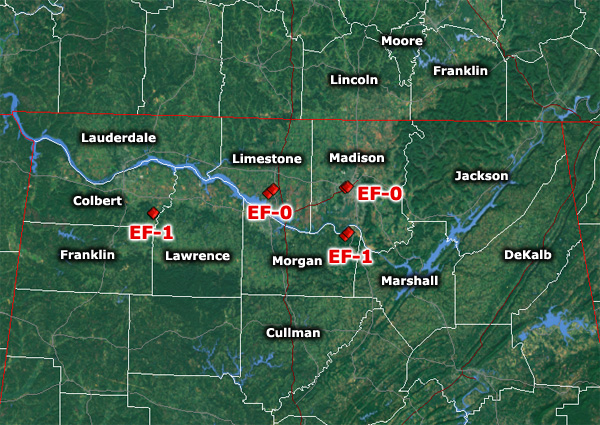
Storm surveys have been completed examining storm damage that occurred in the early evening hours on Thursday, April 2nd. All tornado ratings use the Enhanced Fujita Scale.
|
|
Eastern Colbert County, AL (Whiteoak)
|
| Rating |
EF-1 |
Peak Wind |
100 mph |
| Path Length |
0.3 miles |
Peak Path Width |
75 yards |
|
|
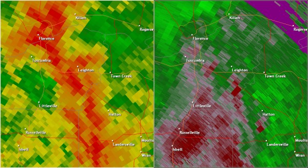
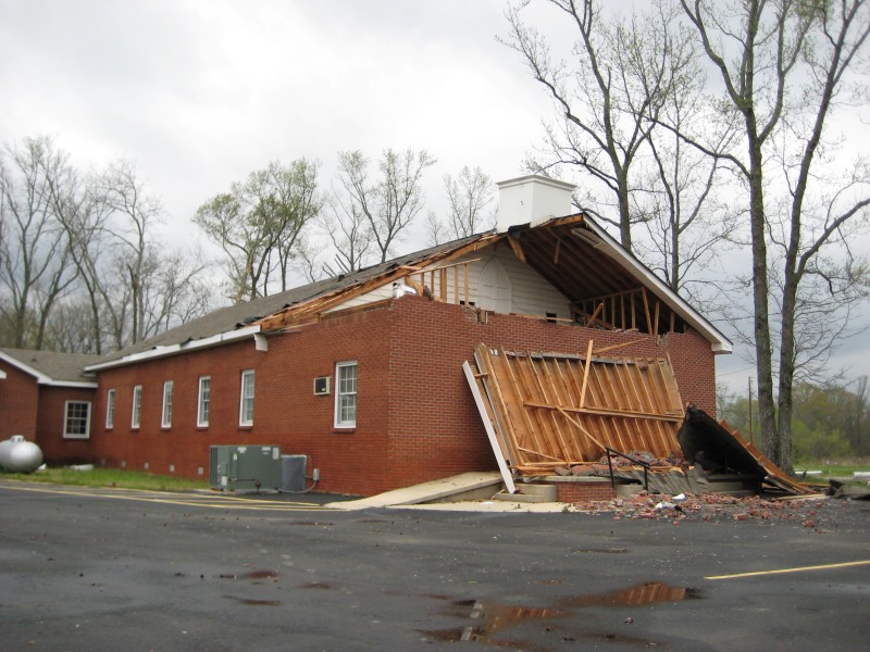
A tornado touched down about one mile south of Whiteoak on County Line Road, damaging the roof of a church and snapping or uprooting several large trees and limbs. After damaging the church, the tornado crossed over County Line Road and produced additional damage. Several medium sized trees were snapped or uprooted northeast of County Line Road, and numerous power lines were downed. The tornado lifted before crossing Highway 157 near Bingham.
|

|

|

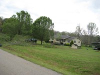
Some homes in the area sustained relatively minor damage but nothing as bad as the damage at the church.
|

This tree was splintered by the tornado.
|
|
Limestone County, AL (Tanner Crossroads) |
| Rating |
EF-0 |
Peak Wind |
80 mph |
| Path Length |
1.7 miles |
Peak Path Width |
50 yards |
|
|
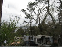
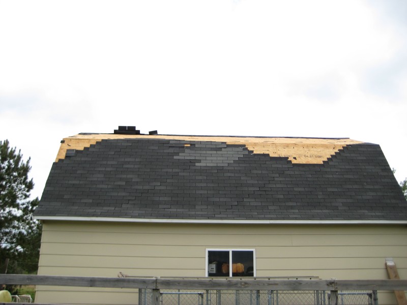
A tornado touched down on Ingram Road, just to the east of Sandlin Street, southwest of Tanner Crossroads. Several small to medium trees were snapped or uprooted. A house also sustained initial damage from the tornado at this location. The tornado continued to snap large trees as it moved northeast towards the intersection of Stewart Road and Rosie Road. At this location, a barn had several sheets of metal peeled back on the roof. Shingles were also blown off of a shed and two houses nearby. The tornado continued moving northeast before lifting near the intersection of Nuclear Plant Road and Highway 31.
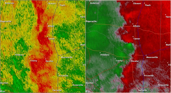
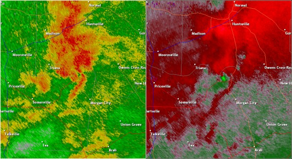
This National Weather Service radar image from 4:35pm shows an area of circulation south and southwest of Tanner. The base reflectivity product in the left panel shows rainfall intensity. The storm relative velocity product in the right panel shows winds toward (in green) and away (in red) from the radar at Hytop, AL.
|
The tornado snapped several trees along Ingram Road, at the beginning of the damage path.
|

The tornado displaced this debris from an outbuilding into a driveway.
|

This garage was damaged by the tornado.
|

The roof of this barn was damaged by the tornado.
|
|
Northeastern Morgan County, AL (Lacey's Spring) |
| Rating |
EF-1 |
Peak Wind |
105 mph |
| Path Length |
1.2 miles |
Peak Path Width |
200 yards |
|
|
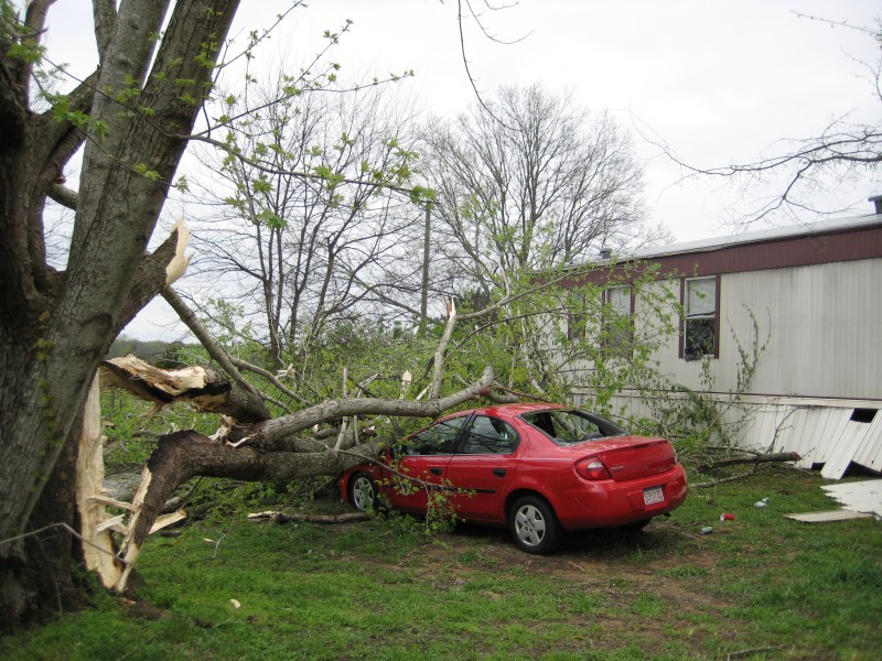
The tornado touched down in a field south of Lower Dry Creek Road in the Lacey’s Spring area, snapping several small trees, and causing minor damage to some residences near the road. The tornado intensified as it crossed Kay Road, snapping larger trees and destroying a shed. The most significant damage occurred as it moved into the Sherbrook Drive area, snapping and uprooting several large trees. Several trees fell onto nearby homes, causing major damage, but the tornado circulation itself did only minor damage to the manufactured houses. The tornado lifted shortly afterwards in the same neighborhood.
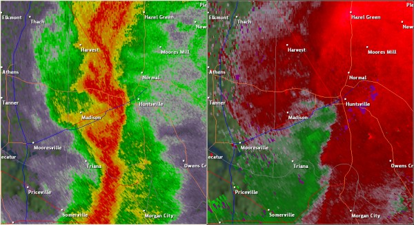
This National Weather Service radar image from 5:27pm shows an tight velocity couplet approaching the Lacey's Spring community. The base reflectivity product in the left panel shows rainfall intensity. The storm relative velocity product in the right panel shows winds toward (in green) and away (in red) from the radar at Hytop, AL.
|

Falling trees caused most of the damage in the Laceys Spring area. This car was among the numerous objects damaged by trees and large tree branches.
|

Not one, but two trees fell on this mobile home, essentially destroying it. Amazingly, two people who were taking cover in this mobile home when the trees fell on it were not injured.
|
This mobile home was split in half by a large tree that fell on it.
|

The roof of this home was damaged near the end of the tornado path. Insulation, shingles, and other debris were scattered by the tornado.
|
|
Madison County, AL (West Huntsville) |
| Rating |
EF-0 |
Peak Wind |
85 mph |
| Path Length |
0.7 miles |
Peak Path Width |
50 yards |
|
|
A tornado first touched down just southwest of Butler High School, snapping or uprooting several large trees or limbs, one of which fell on top of a nearby home. Several small- to medium-size trees were snapped or uprooted on the Butler High School campus, then the tornado crossed the road and caused further tree damage in the Fairway Drive area north of Holmes Avenue. The tornado lifted before exiting the neighborhood.
This National Weather Service radar image from 8:06pm shows weak rotation in the western part of Huntsville along I-565. The base reflectivity product in the left panel shows rainfall intensity. The storm relative velocity product in the right panel shows winds toward (in green) and away (in red) from the radar at Hytop, AL.
|
Near the beginning of the tornado path, large tree limbs were blown onto this house.
|

This row of trees in front of Butler High School was damaged by the tornado. Interestingly, only certain branches of the trees were snapped, while some remained mostly unharmed.
|

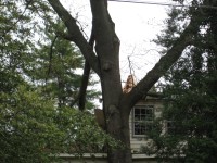
This large tree was uprooted by the tornado.
|

Near the end of the tornado path, utility crews were still working to remove limbs and restore power to houses north of Holmes Avenue.
|
|
|
|


 Local Radar
 Weather Map