|
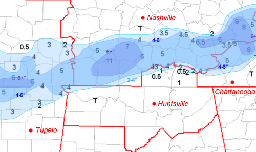
A snowfall map from Feburary 14-15, 2004. Note that Summertown, in northern Lawrence County, Tennessee, reported almost a foot of snow! (On this map, the lightest shade of blue indicates 2-4” of snow, the medium blue 4-6”, and the purple shade indicates more than 6”. The red lines indicate boundaries between NWS county warning areas). There was an awful lot of discussion about snow on Valentine's Day Weekend 2004. Yet much of the Tennessee Valley received only flurries, and some areas saw no snow whatsoever. (It should be noted, however, that parts of Lincoln, Franklin, and Moore Counties in Tennessee saw 2-4" of snow, and extreme northwest Lauderdale County, Alabama received 2-4" as well.) You're not alone in asking, "What happened?" In fact, we're asking that question ourselves here at the National Weather Service. We're taking a close look at the event to see what happened, and how we can improve similar forecasts in the future.
The storm in question was a large low pressure system and pool of cold air aloft that moved almost due east out of the Rockies. It moved just to the south of Dallas-Fort Worth on Saturday (Valentine’s Day), then moved over Shreveport, Louisiana. On its way, the system produced snow over a wide swath of the southern United States, giving the Dallas-Forth Worth area 2-4 inches and parts of southern Arkansas up to 8 inches of snow. By the time Sunday the 15th rolled around, the center of the storm was located between Meridian, Mississippi, and Tuscaloosa, Alabama. Forecasters at the National Weather Service in Huntsville had been watching all of this with great interest. The pool of cold air aloft was expected to allow snow to develop, but there was some question about whether it would get cold enough in the lower levels of the atmosphere for the flakes to survive without melting. In addition, for much of the system’s path across the southern U.S., the heaviest snow had fallen well to the north of the system. The forecasters expected this behavior to continue as the center of the storm passed over central Alabama. However, these heavier snow bands often develop on a smaller scale called the mesoscale, and mesoscale features are often hard to predict. So the main questions on the morning of the 15th were: At first, it looked like the heavy snow band was aimed right at the Tennessee Valley. Rain that had fallen for much of the night was beginning to change to snow. Reports out of the NWS Memphis office on Sunday morning indicated that such a band had formed over northeastern Mississippi and parts of western Tennessee: heavy snow was being reported, and the snow had caused downed power lines and many road closures. As the morning wore on, reports out of Lauderdale County suggested that the heavy snow was beginning to impact the Huntsville forecast area, right along the Alabama-Mississippi State Line, and just west of the Natchez Trace Parkway. A rain-snow mix was reported across much of the area, at just about all of our major reporting sites, and as far south as Cullman. It looked like, finally, all the ingredients had come together for a southern snowstorm affecting the Tennessee Valley.
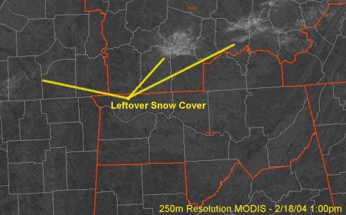
Not quite. Several features in the upper atmosphere came together over southern middle Tennessee to produce an area of very strong lift. This feature, called a deformation zone by meteorologists, shifted the axis of heavy snow from just to our west, to just to our north. By midday Sunday, Lawrence County, Tennessee was reporting heavy snow, and portions of Interstate 65 in Giles County were closed for a few hours. Moisture to our west dried up, and precipitation came to an end quickly across much of the area as the center of the storm system continued eastward. In many places, temperatures in the lowest levels of the atmosphere remained well above freezing for much of the day, and as a result, our rain never fully changed over to snow. However, so much snow fell across parts of Tennessee on Sunday that you could still see evidence of it on Wednesday. Visible satellite imagery on that day shows white patches that coincide with the bulls-eyes on the snowfall map. (Note that Wednesday was a clear day…so you’re seeing snowfall on the ground rather than clouds!) |


 Local Radar
 Weather Map