National Weather Service United States Department of Commerce
Click a location below for detailed forecast.

Last Map Update: Mon, Mar 31, 2025 at 9:18:23 am CDT

A severe thunderstorm watch has been issued for parts of Alabama, Georgia and Mississippi until 12 PM CDT
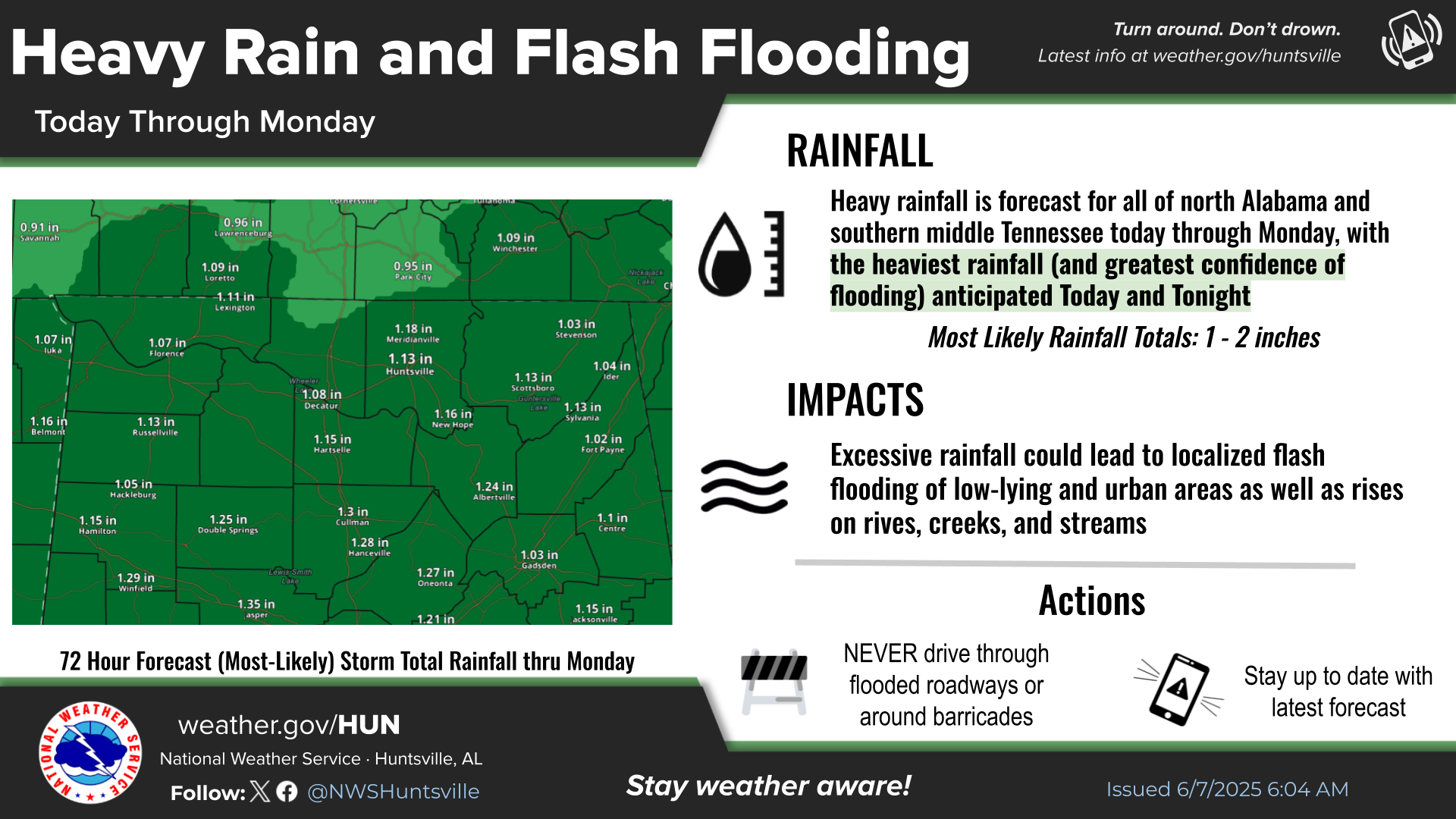
There is a risk of more strong to severe storms Wednesday through Friday. However, there is tremendous uncertainty in this portion of the forecast, especially regarding storm coverage and impacts, so please check back for updates regarding the latest forecast trends.
High temperatures and precipitation chances for today.
Low temperatures and precipitation chances for tonight.
High temperatures and precipitation chances for tomorrow.
This graphic contains daily climate data (climate normals and records) for today for the sites listed. The legend is in the upper left portion of the image. The current normals period is 1991-2020.


Location Sky/Weather Temp Dewpt RH Wind Baro Remarks
Huntsville


Muscle Shoals


Decatur


Meridianville


Vinemont


Albertville


Scottsboro


Fort Payne


Winchester


Tullahoma


Fayetteville


Courtland


Note: "N/A" or "MISG" will be displayed if values are not available. In the LOCATION column, click on links for a list of recent observations at sites of interest. In the WIND column, VRB is "variable" and G is "gust". Wind speeds are in MPH. In the BARO (pressure) column, values are in inches. In the REMARKS column, HX is "heat index", WCI is "wind chill index", and VSB is "visibility" (if shown).
Text Product Selector (Selected product opens in a new window)
SITREP GRAPHICAL HWO DISCUSSION FIRE WX AVIATION WX HYDROLOGY
 
AIR QUALITY GRIDDED FORECAST FORECAST (HR) CLIMATE CLIMATE GRAPHS OBSERVATIONS
 
SATELLITE WX RADIOS   STORM SPOTTER TRAINING   PAST EVENTS GIS TORNADO HISTORY
Daily Climate for Middle Tennessee
EDUCATION BEING PREPARED ESTAR PREPARANDO