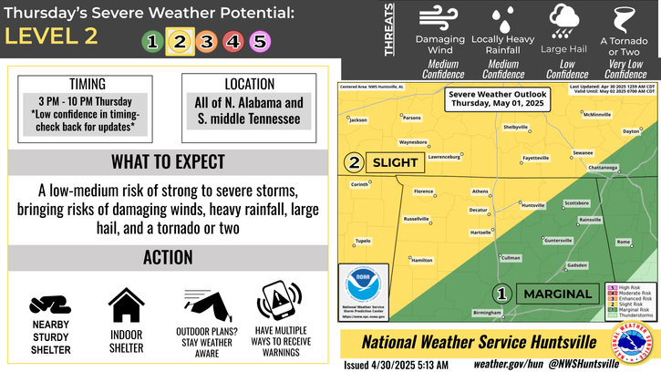
National Weather Service United States Department of Commerce
Click a location below for detailed forecast.

Last Map Update: Fri, Mar 28, 2025 at 6:22:27 am CDT

Severe storms will be possible as a system moves through the TN Valley from Sunday overnight into Monday morning. All hazards look to be possible including damaging winds, large hail, and tornadoes (low confidence in seeing tornadoes). Please check back for updates on timing as the event draws closer.
Dry weather continues through the end of the work week with highs in the mid to upper 70s (potentially hitting 80 in some areas Friday). This weekend, rain chances return along with gusty, non-thunderstorm winds up to 20-25 mph. Be sure to secure loose, outdoor objects! Severe storms will be possible Sunday night into Monday morning. Be sure to check back in as we approach the weekend for updates on hazards and specific timing.
High temperatures and precipitation chances for today.
Low temperatures and precipitation chances for tonight.
High temperatures and precipitation chances for tomorrow.
This graphic contains daily climate data (climate normals and records) for today for the sites listed. The legend is in the upper left portion of the image. The current normals period is 1991-2020.
Heavy rainfall chances will increase late next week, and we will have to monitor the potential for flooding concerns next weekend. Stay tuned for updates to the forecast.


Location Sky/Weather Temp Dewpt RH Wind Baro Remarks
Huntsville


Muscle Shoals


Decatur


Meridianville


Vinemont


Albertville


Scottsboro


Fort Payne


Winchester


Tullahoma


Fayetteville


Courtland


Note: "N/A" or "MISG" will be displayed if values are not available. In the LOCATION column, click on links for a list of recent observations at sites of interest. In the WIND column, VRB is "variable" and G is "gust". Wind speeds are in MPH. In the BARO (pressure) column, values are in inches. In the REMARKS column, HX is "heat index", WCI is "wind chill index", and VSB is "visibility" (if shown).
Text Product Selector (Selected product opens in a new window)
SITREP GRAPHICAL HWO DISCUSSION FIRE WX AVIATION WX HYDROLOGY
 
AIR QUALITY GRIDDED FORECAST FORECAST (HR) CLIMATE CLIMATE GRAPHS OBSERVATIONS
 
SATELLITE WX RADIOS   STORM SPOTTER TRAINING   PAST EVENTS GIS TORNADO HISTORY
Daily Climate for Middle Tennessee
EDUCATION BEING PREPARED ESTAR PREPARANDO