| Rating |
EF-4 |
Peak Wind |
180 MPH |
| Path Length |
20.5 Miles |
Peak Path Width |
3/4 Mile |
| Starting Point |
34.7948, -85.9090 |
Ending Point |
34.98537, -85.63767 |
| Starting Time |
05:05 PM CDT |
Ending Time |
05:25 PM CDT |
|
| Tornado Track Map - Jackson County Only

|
|
Click on the image above to display an experimental contoured map created by Suheiley Lopez (UPRM) dipicting the strength of damage indicators seen along the track during NWS storm surveys.
|
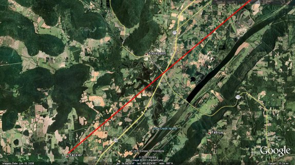
Zoomed in Image of Track From: Just NE of
Fackler to NE Of Stevenson
|
|
|
|
|
|
|
| The tornado initially touched down northeast of the Fackler community along County Road (CR) 42 where several large trees were snapped and there was minor damage to mobile homes. The tornado then continued east-northeast, producing tree damage as it crossed Highway 72 near the intersection of Alabama Highway 117. On Oak Hill Road just east of Hwy 72, large trees were snapped and roof damage was observed on several residences. On CR 286, a trailer was tipped over and a shed was partially destroyed. The tornado continued northeast producing heavy tree damage. EF-3 damage was observed along CR 96 just northeast of the Stevenson Airport where 24 high tension electrical truss towers were twisted and flattened. Just south of the intersection of CR 96 and Alabama Hwy 277, a mobile home was obliterated and another home collapsed. Two other homes sustained structural damage along this section of road, two mobile homes were rolled on their side, and a metal barn was destroyed. |
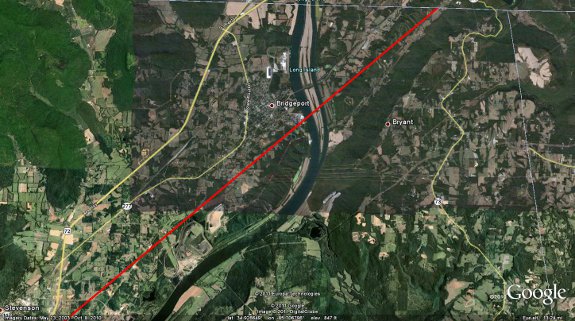
Zoomed in Image of Track From:
NE of Stevenson to Bridgeport to Marion County, TN
|
|
|
|
|
|
|
|
The tornado continued to the northeast and at the intersection of CR 255 and CR 256 the most significant damage was observed, rated EF-4. A residence just to the south of this intersection was reduced to its foundation. A concrete slab at the front of the home was pulled up and a set of concrete stairs was ripped from the foundation. A compact car was thrown about 50 yards from this residence as well. To the northeast of the intersection, two well-built and well anchored homes were also reduced to their foundation. A car was thrown approximately 50 yards across the street from one residence. Several large trees were snapped off a few feet above the ground and a third residence along CR 256 was observed with no walls left standing. Across the street from this home, a mobile home was completely demolished and strewn along CR 256. This tornado continued northeastward and destroyed a cinder block garage and damaged a mobile home along 6th street just southeast of Bridgeport. The tornado then crossed the Tennessee River and continued to produce significant tree damage along CR 91 until the tornado crossed out of the NWS Huntsville forecast area and into Marion County Tennessee (NWS Morristown, TN area).
|
|
|
Back to April 27 Survey Info
|


 Local Radar
 Weather Map