 |
|
2017 Tropical Weather |
|||
 |
|||
| Visible satellite image of a very active Atlantic Basin on September 8, 2017. The large hurricane at the center is Irma whose remnants impacted Georgia and Northeast Alabama later the next week. To the left is Hurricane Katia and to the right is Hurricane Jose. | |||
|
Tropical Systems that Impacted the Tennessee Valley during the 2017 Season:
* It should be noted that these system were significantly weaker when they impacted the Tennessee Valley. In fact, most of these systems had been downgraded to Tropical Depressions or had already undergone extratropical transition. However, strong gradient winds, heavy rainfall, and/or a few tornadoes accompanied all these systems. Harvey and Irma, in particular, had wide-ranging and significant impacts across the United States mainland and the Caribbean. For more information on these hurricane and their impacts across the Atlantic Basin, please visit the National Hurricane Center's webpage at: https://www.weather.gov/hun/2017_tropical​ |
|||
| Tropical Depression Cindy (June 22-23, 2017) | |||
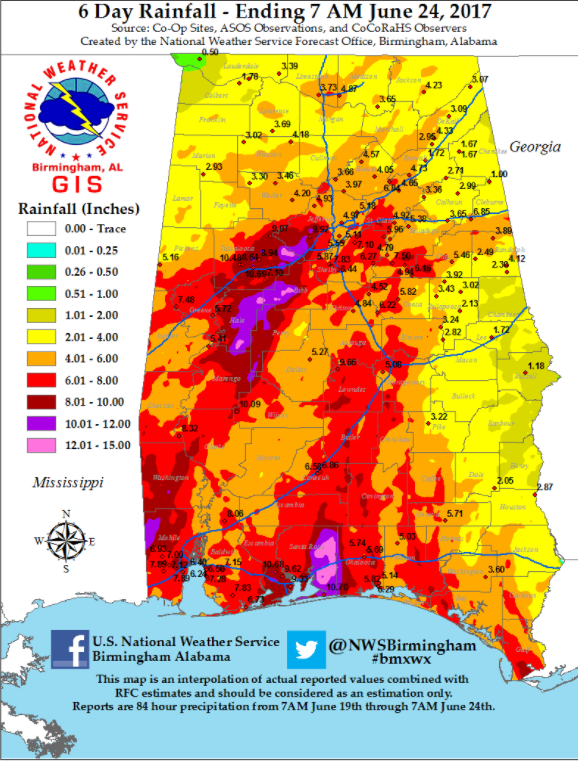
| Cindy was the 3rd named storm of the 2017 Atlantic hurricane season. She developed out of broad area of low pressure in the western Caribbean, which slowly drifted north with time into the Gulf of America. Atmospheric conditions were favorable for Cindy to organize into a Tropical Depression and later a Tropical Storm by June 20. Cindy maintained her northwest drift on the 21st and 22nd, but was unable to intensify and organize further due to the presence of drier air along the Northern Gulf Coast and some moderate to strong upper-level wind shear. Cindy later made landfall in southwestern Louisiana on June 22, and quickly weakened to a Tropical Depression as her remants track across Southern Mississippi into Central Alabama. While a few gusty winds of 20 to 30 were felt across portions of the Tennessee Valley, the primary impact was heavy rainfall as noted by the map below. A few tornadoes were observed across South Alabama and Mississippi as well. | |||
 |
|||
| Tropical Storm Cindy brought heavy rainfall to Alabama, especially along the Gulf Coast and across potions of West Central Alabama. Closer to home, between 2 to 4 inches was common. | |||
 |
|||
| Satellite Image of Tropical Storm Cindy as she approaches the Northern Gulf Coast on June 22, 2017. | |||
| Tropical Depression Harvey (August 30-31, 2017) | |||
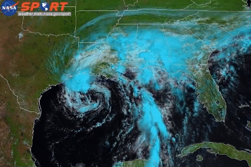
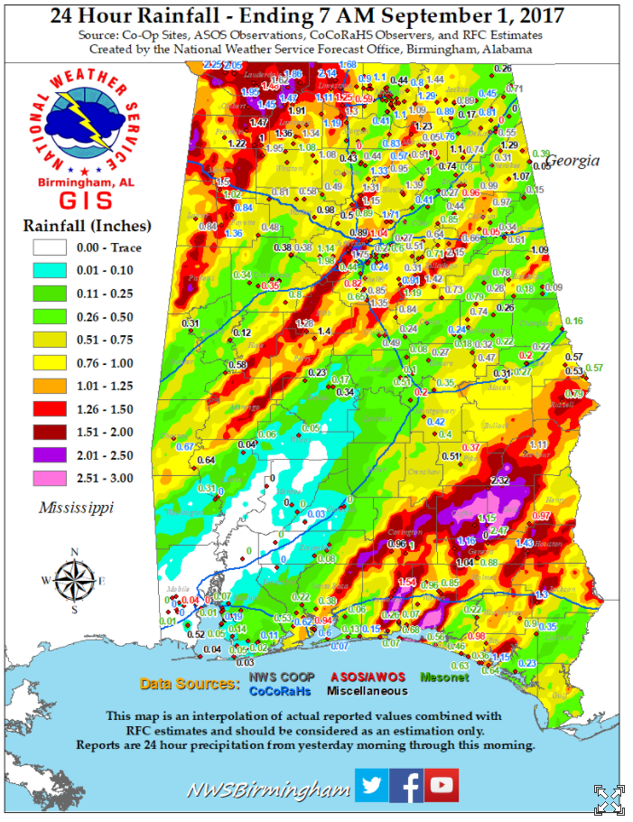
| Tropical Depression Harvey moved northeast from Louisiana through northern Mississippi and into central Tennessee Thursday (August 29th) into Friday (August 31st). Harvey was no where near the potent hurricane when it made landfall along the coastal bend of Texas August 25th, nor the efficient rain producer it was along the Texas and Louisiana Gulf Coast region. Nevertheless, Harvey continued its trend of producing flooding rainfall and severe thunderstorms including some tornadoes across these areas. Some heavy rainfall between 2 and 4 inches was seen across Northern Alabama from Thursday, August 31st through the early morning hours of Friday, September 1st. Also, some severe storms also occurred. One of these storms produced a EF2 tornado in Marshall and Cullman counties further east in north-central Alabama. A few other tornadoes were documented further to the south across Central Alabama. | |||
| For more details, click here for the NWS Huntsville write-up on this event. | |||
 |
|||
| Tropical Depression Harvey brought heavy rainfall to portions of Alabama, specifically the far southeastern portions of the state and the western Florida Panhandle. Closer to home, Northwest Alabama experienced the most rainfall due to slow-moving, training showers and storms that developed during the afternoon. | |||
 |
|||
| GOES-16 RGB showing the center of TD Harvey making landfall across the ArkLaMiss. The dry slot over MS (red) that helped destabilize the atmosphere and increase the risk for severe weather across Alabama during the afternoon and evneing of August 31, 2017. | |||
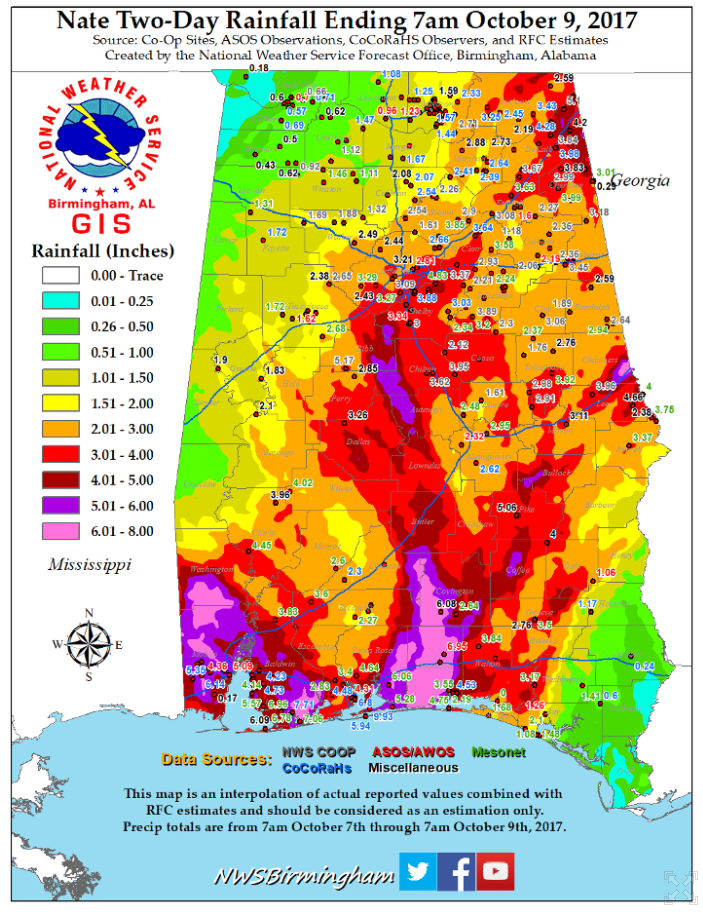
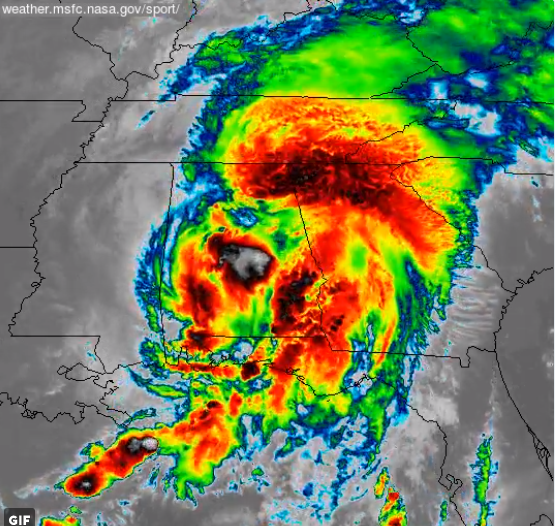
| Tropical Depression Nate (October 8, 2017) | |||
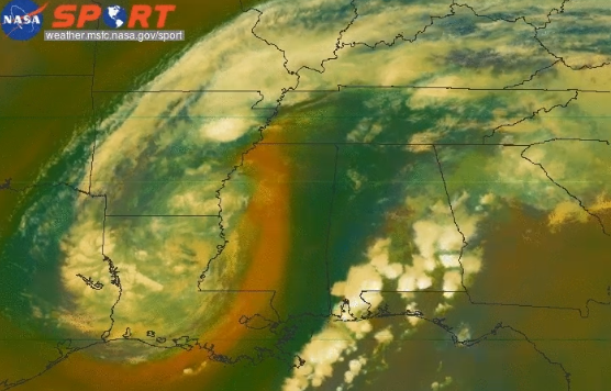
| Hurricane Nate formed from a weak tropical disturbance over the western Caribbean on October 5th. As the system drifted into the Gulf of America on October 7th, Nate organized into a Tropical Storm and eventually deepened into a Category 2 hurricane as it rapidly approached the Mississippi Delta region and the Alabama Coast. Impinging vertical wind shear caused Nate's convection to rapidly warm and lose structure as the hurricane made landfall during the early morning hours of October 8th. Nate rapidly weakened upon landfall to a Tropical Depression late morning on the 8th as its remants moved into Central and Northeast Alabama. Gradient winds of 25-35 mph were observed, with the highest gusts along the Plateau of Northeast Alabama. Despite the deep tropical moisture that moved into the region, Nate's rapid forward motion cutdown on any significant precipiation and flooding concerns. | |||
 |
|||
| Tropical Depression Harvey brought heavy rainfall to portions of Alabama, specifically the Gulf Coast region where 4" to 6" were common. Closer to home, Northeast Alabama received 2" to 4" of rain, with slightly lesser amounts elsewhere across the Tennessee Valley. | |||
 |
|||
| The remnants of Nate moving across Alabama during the morning hours of October 8, 2017. | |||


 Local Radar
 Weather Map