
Dry fuels, strong winds and dry weather will continue to bring elevated to critical fire weather conditions to the areas of the Plains, Midwest and Southeast today. A Pacific storm system will bring low elevation rain and heavy high elevation mountain snow to California through early week, expanding into the Pacific Northwest, Great Basin, and southern California on Tuesday. Read More >
STORM SIGNALS
Spring 2001, Vol. 57
CONTENTS
This edition of Storm Signals was printed by
![]()
of Texas City as a service to the citizens of
Southeast Texas and the upper Texas Coastal Area.

Governor Rick Perry has proclaimed the week of March 4-10 as Severe Weather Awareness Week for the state of Texas.
During Severe Weather Awareness Week, the National Weather Service in coordination with the Texas Division of Emergency Management and the Insurance Information Institute will highlight various aspects of severe weather through press releases and Public Information Statements. Newspapers, broadcast media, safety organizations and other local government officials are encouraged to work with their communities to disseminate severe weather awareness information in order to prepare them for the upcoming severe weather season.
During each day of Severe Weather Awareness Week, special releases will be made by the National Weather Service to further emphasize important information about severe weather and the National Weather Service's job in warning the public.
| DATE | TOPIC |
|---|---|
| Sunday, March 4 | Introduction to Severe Weather Awareness Week |
| Awareness and Preparedness | |
| Monday, March 5 | Lightning (Facts and Safety Tips) |
| Severe Thunderstorms (Facts and Safety Tips) | |
| Tuesday, March 6 | Tornadoes (Facts and Safety Tips) |
| Flash Floods/Floods (Facts and Safety Tips) | |
| Wednesday, March 7 | Watches and Warnings |
| SKYWARN | |
| Thursday, March 8 | NOAA Weather Radio/S.A.M.E |
| EMWIN | |
| Friday, March 9 | Storm Ready |
| Building Safer Homes |

The 2001 Houston International Boat Show was held at the Reliant Astrohall and Astroarena from January 5th through January 14th. Similar to the past several years, our office set up a booth among the other venders of boats, marine products and services. Over 147,000 people attended the 10 day event and this was a great opportunity for the Houston/Galveston staff to meet with the marine community as they passed by the NWS booth.
A variety of handouts were available to the public. The most popular brochures included those about hurricanes/tracking charts, thunderstorms and tornados, safe boating, tide tables for Galveston Channel, and nautical chart catalogs. In addition, hundreds of business cards with the office's web page address and phone number of the forecast recording were distributed.
Positive comments regarding the NWS marine forecasts were received from the majority of those that stopped by to chat. Many users were happy that the marine forecast has been expanded to a full 5 days of winds, seas and weather. Others were happy with the various means available to obtain weather information ranging from NOAA Weather Radio, phone recordings and the internet.
It is always good for our forecasters to hear your feedback - it shows that the products we issue are used and are an important tool for local mariners. Those not able to attend this years show are also encouraged to provide feedback regarding our local marine program by e-mailing me at brian.kyle@noaa.gov

The annual Houston/Galveston Hurricane Workshop will take place on May 9 at the Pasadena Convention Center from 8am til 12 noon. This year's theme will center around Hurricane Carla.
Mr. Ray Miller, who was the News Director at KPRC Channel 2 during Hurricane Carla, will share with us how this storm was covered by the media and some of the problems they encountered. You might remember that Hurricane Carla was the first time live radar was broadcast on television. We will also hear on how the media coverage of hurricanes has changed over the last 40 years. This year there will be three break out sessions. Jim Brown will be back to talk more about what you can do to your home or small business to mitigate potential damage during a hurricane. The second breakout session will deal with how to handle people with special needs during a hurricane evacuation. In the third breakout session representatives from the Petro-Chemical Industry will share information about their hurricane preparedness plan. Dr. Jack Beven, Hurricane Specialist with the National Hurricane Center, will wrap things up with a talk on how things have changed in forecasting storms since Hurricane Carla.
The workshop is again being sponsored by the East Harris County Manufacturers Association (EHCMA), the City of Pasadena and State Farm Insurance. There will be numerous vendors on hand displaying information on how to be prepared for the upcoming hurricane season. The workshop is free and open to the public.

It is not too late to schedule your Skywarn meeting to prepare for the severe weather season this Spring. Just pick up the phone and contact Gene Hafele at 281-337-5074 x223 to schedule your class today. Programs can be scheduled during the evening or during the day to maximize your attendance.
What is Skywarn? Skywarn is a program sponsored by your National Weather Service Office in conjunction with your local Emergency Management Organization. It is a group of trained volunteers that watch the skies during severe weather and relay reports back to the local Emergency Management Office, the local law enforcement agency, and/or the National Weather Service. These volunteers provide valuable information to their local community and to the National Weather Service which helps improve the warning program, thus possibly saving lives and reducing property damage in the community.
This year's Skywarn program will emphasize communication (how are spotters activated and how are spotter reports relayed back to the National Weather Service?). It is important that we communicate with our spotters in real time. Knowing what kind of severe weather a storm is producing in real time will enhance our warnings and hopefully save lives and reduce damage.
| City of Galveston Town Meeting |
|---|
The annual City of Galveston Town meeting will take place on Tuesday May 8 at the Moody Gardens Convention Center. The meeting will run from 5pm until 8pm with vendors opening at 5pm and the program beginning at 6pm. Dr. Jack Beven, Hurricane Specialist with the National Hurricane Center, will be the featured speaker. Dr. Beven will be discussing recent hurricane seasons and how forecasting tropical cyclones continues to improve with new technology. This meeting is open to the public. For further information contact William Zagorski, City of Galveston Emergency Management Coordinator, at 409-797-3710.
 |
Galveston County Hurricane Awareness Day |
|---|
The Galveston County Cooperative Emergency Management Committee is sponsoring the first Galveston County Hurricane Awareness Day. The meeting will take place on June 16, from 11am until 2pm at the League City Civic Center (400 West Walker in League City). Representatives from all of the communities throughout Galveston County will be on hand to answer your questions about hurricane preparedness in Galveston County. Mr. Bill Read, Meteorologist In Charge of the Houston/Galveston National Weather Service, will speak on the impact that a Hurricane Carla type storm would have in 2001. The meeting is free and open to the public. For further information on this meeting please contact the Galveston County Office of Emergency Management at 281-309-5002.
| Fujita Wind Damage Scale | ||
| Classification | Wind Speed | Damage |
|---|---|---|
| FO | 72 MPH | Light |
| F1 | 73-112 MPH | Moderate |
| F2 | 113-157 MPH | Considerable |
| F3 | 158-206 MPH | Severe |
| F4 | 207-260 MPH | Devastating |
| F5 | 260-319 MPH | Incredible |
The availability of radar data on the WWW has changed recently to come directly from the National Weather Service. Formerly the data made a circuitous route from the NWS to private vendors in the Nexrad Information Dissemination System and back to the NWS and then to Internet users.
On our web page you will find an updated link to the radar section in the new format. The radar products now available are Reflectivity (lowest elevation slice), Composite Reflectivity (a compilation of all reflectivity elevation slices), Rainfall (one hour radar estimates of accumulation), and Storm Total Rainfall (event total radar estimates), and all can be looped. The radar products are also available in a mosaic form for the entire nation. The national loop is 4 hours long. The local site specific loops are 10 frames long and the duration varies depending upon the mode the radar is operating within. While the radar is in precipitation mode, the loop will be approximately 50 to 60 minutes long. While in clear air mode the loop will average around 90 minutes. A few additional features that are available while looping are zooming, setting the loop speed, and in the event that you find a corrupted image in a loop you can skip the corrupted image by left clicking the small green box that coincides with the image in question. You can find the zoom button on the upper right side.
To navigate from one radar to the nearest adjacent radar you will note a compass on the left side of the screen with blue arrows. When you select an arrow, the site will take you to the nearest radar in the direction you selected. While on the national reflectivity image you can use the cursor to click anywhere on the U.S. map to take you to the selected location or you can use the pull down menu that is organized alphabetically by state. When you get to a specific radar site, you will find a link on the lower-left side that will transfer you to the webpage of the office responsible for forecasts and warnings in your area of interest.
The radar data is usually updated in 1 to 5 minutes after the data is generated. In the upper right-hand corner you will find a time and date stamp on the product. The pages currently require you to refresh/reload the images to get the latest data.
Happy radaring!
The old adage "if you don't like the weather wait a while" appropriately describes the weather across southeast Texas this year. The area endured a significant drought...all-time record heat...24 hour and monthly rainfall records...tornadoes and an ice storm. At least the area didn't have to endure a hurricane!
January was an unusually warm month with temperatures averaging 5 to 7 degrees above normal. Rainfall was below normal over most of the area and it was the sixth straight month of below normal rainfall and one of the driest six month periods in recorded weather history. On January 27th...a complicated weather pattern developed in which freezing rain and sleet developed over the northeast part of the area during the late morning and early afternoon and a tornado watch was in effect over the south. Thunderstorms produced 50 mph wind gusts from Alvin to Wharton.
February continued a trend of above normal temperatures and below normal rainfall. Average temperatures were 7 to 8 degrees above normal for the month. Rainfall deficits were not as large as previous months but most locations were between 0.5 and 1 inch below normal. Other than periods of dense fog...little significant weather occurred.
March was another unusually warm month with temperatures averaging 4 to 6 degrees above normal. Rainfall was approaching near normal levels over the north but southern sections of southeast Texas remained on the dry side. March was a stormy month as well. On March 10th, an F3 tornado ripped through Burleson county producing significant damage. Sixteen days later...another round of thunderstorms producing large hail and strong winds raced across the eastern half of the region.
April was about as close to climatological normals as any month this year. Temperatures were about a degree warmer than normal. Rainfall was slightly above normal near the city of Houston with lesser totals north and south of the city. Spring is the time of year when severe storms typically strike southeast Texas. The first half of April was plagued with severe weather. Numerous thunderstorms producing large hail and damaging winds assaulted the area. Two persons were injured when a strong downburst struck the Hockley area on April 2nd.
May averaged about 2 degrees above normal which continued a trend that started back in August of 1999. The most unusual weather of the month occurred on the 19th and 20th. A nearly stationary line of thunderstorms developed from near Intercontinental Airport to Liberty. This line of storms dumped over 7 inches of rain at the airport and over 19 inches in the town of Liberty. By the end of May...Liberty had received over 24 inches of rain which established a new monthly rainfall record.
May also produced more severe weather. A large thunderstorm complex developed on the 2nd and raced across the region. Gusty downburst winds tore roofs off buildings...destroyed barns...uprooted trees and overturned planes at Clover Field and Scholes Field.
June signaled the end of spring and the beginning of summer...and what a summer it turned out to be. Temperatures began to rise and rainfall began to decline. Temperatures averaged 1 to 3 degrees above normal and rainfall was 2 to 3 inches below normal. Severe weather was rather limited except for some flooding early in the month over the southeastern portion of the region.
July was hot...averaging 1 to 3 degrees above normal. It was also very dry and southeast Texas was suffering from severe to extreme drought conditions. Rainfall for the month was another 2 to 3 inches below normal. During mid-July...temperatures soared well above 100 degrees. The Houston area reached the 100 degree threshold on ten days while the College Station area endured thirteen 100 degree days. A thunderstorm complex developed on July 23rd and raced southwest across the region. These storms uprooted trees... blew over utility poles and knocked down billboards from Chambers county to Colorado county.
August was also hot. Temperatures were relatively normal for the first three weeks of the month. Temperatures blistered toward the end of the month. Rainfall remained below normal for the third consecutive month. Intercontinental Airport established or tied four new high temperature records at the end of the month. All three climate stations established new monthly high temperature records, Intercontinental Airport recorded 107 degrees, Galveston recorded 100 degrees and College Station recorded 109 degrees. These values either tied or established new monthly temperature records.
The early September heat wave was amazing not only in it's intensity but in it's duration. Intercontinental Airport established new high temperature records for the first six days of the month. If that isn't amazing enough...all three climate sites established new monthly and all-time temperature records. On September 4th, Intercontinental Airport reached 109 degrees and College Station reached 112 degrees. The following day...Galveston established it's new monthly and all-time high temperature record of 104 degrees. The intensity and duration of the August-September 2000 heat wave and the associated physiological and economic costs is one of epic proportions and should receive the same historical significance as other southeast Texas events.
The intense heat in early September helped trigger thunderstorm development. These storms became severe in a few locations and in fact produced wind damage over the eastern half of the region. The strong straight line winds produced injuries and even a fatality in Trinity county.
A welcome respite from the intense summer heat and drought developed in October. Temperatures were 1 to 2 degrees above normal for the month. Rainfall was about an inch below normal areawide. Compared to the last three months...October was a tolerable change of pace.
November was the first month in almost three years in which the average temperature was greater than 3 degrees below normal. College Station and Galveston had monthly temperatures 5 degrees below normal. Rainfall for the month was well above normal. In fact...Huntsville and Jamaica Beach each established new monthly rainfall records. Galveston had it's second wettest November. Most areas north of Highway 105 and east of US Highway 59 received greater than 10 inches of rain for the month. Heavy rainfall from the evening of the 2nd through the 4th produced major flooding over the northwest counties of southeast Texas with numerous cars stranded and several homes and businesses flooded. Stormy skies in November produced more than rain. High winds produced widespread damage and injuries on the 5th. Isolated tornadoes ripped through the Houston metro area on Thanksgiving night with damage in Katy and Pasadena.
December temperatures were also 3 to 5 degrees below normal marking the first time in three years that temperatures across the region were below normal for two consecutive months. Rainfall was slightly above normal over the north...below normal central and south. The colder than normal temperatures brought sub-freezing temperatures and wintry precipitation to the region. An ice storm affected the region north of a Columbus to Navasota to Huntsville line on the 13th. Ice accumulations of between 0.5 and 1 inch created hazardous driving conditions and numerous power outages. On December 31st...snow developed over the extreme northeastern edge of southeast Texas. Snow accumulations in this area were between 0.5 and 1 inch.
| HOUSTON INTERCONTINENTAL AIRPORT | ||||||
|---|---|---|---|---|---|---|
| Month | Average High |
Average Low |
Daily | Departure | Rainfall | Departure |
| January | 67.2 | 45.6 | 56.4 | +6.0 | 1.25 | -2.04 |
| February | 73.6 | 50.1 | 61.9 | +8.0 | 2.32 | -0.64 |
| March | 77.9 | 54.8 | 66.4 | +5.8 | 1.35 | -1.57 |
| April | 79.4 | 56.3 | 67.9 | -0.4 | 5.52 | +2.31 |
| May | 87.0 | 69.2 | 78.1 | +3.6 | 12.35 | +7.11 |
| June | 90.4 | 72.3 | 81.4 | +1.0 | 3.29 | -1.67 |
| July | 97.7 | 72.7 | 85.2 | +2.6 | 0.64 | -2.96 |
| August | 97.4 | 72.2 | 84.8 | +2.5 | 2.11 | -1.38 |
| September | 92.1 | 66.6 | 79.4 | +1.2 | 4.34 | -0.55 |
| October | 80.9 | 60.9 | 70.9 | +1.3 | 3.27 | -1.00 |
| November | 67.2 | 48.0 | 57.6 | -3.4 | 8.50 | +4.71 |
| December | 57.4 | 37.7 | 47.6 | -5.9 | 2.67 | -0.78 |
| 2000 | 80.7 | 58.9 | 69.8 | +1.9 | 47.61 | +1.54 |
| Normals | 78.6 | 57.3 | 68.0 | . | 46.07 | . |
| GALVESTON SCHOLES FIELD | ||||||
|---|---|---|---|---|---|---|
| Month | Average High |
Average Low |
Daily | Departure | Rainfall | Departure |
| January | 65.1 | 52.6 | 58.9 | +6.2 | 1.74 | -1.52 |
| February | 68.9 | 56.2 | 62.6 | +7.4 | 1.71 | -0.55 |
| March | 73.9 | 62.1 | 68.0 | +6.3 | 1.92 | -0.31 |
| April | 76.8 | 65.3 | 71.1 | +1.8 | 2.25 | -0.18 |
| May | 83.5 | 74.3 | 78.9 | +3.1 | 4.61 | +1.02 |
| June | 87.9 | 78.6 | 83.3 | +2.2 | 1.11 | -3.33 |
| July | 90.5 | 78.8 | 84.7 | +1.4 | 0.95 | -3.01 |
| August | 91.5 | 79.3 | 85.4 | +1.9 | 1.26 | -3.21 |
| September | 87.8 | 73.9 | 80.9 | +0.9 | 6.28 | +0.35 |
| October | 79.1 | 68.1 | 73.6 | +0.8 | 1.62 | -1.22 |
| November | 67.4 | 54.7 | 61.1 | -3.1 | 14.30 | +10.93 |
| December | 58.1 | 44.7 | 51.4 | -5.0 | 2.54 | -0.96 |
| 2000 | 77.6 | 65.7 | 71.7 | +2.0 | 40.29 | -1.99 |
| Normals | 74.3 | 65.0 | 69.7 | . | 42.28 | . |
| COLLEGE STATION - EASTERWOOD FIELD | ||||||
|---|---|---|---|---|---|---|
| Month | Average High |
Average Low |
Daily | Departure | Rainfall | Departure |
| January | 64.8 | 43.3 | 54.1 | +5.6 | 3.14 | +0.49 |
| February | 73.2 | 47.6 | 60.4 | +8.0 | 0.91 | -1.71 |
| March | 75.5 | 53.5 | 64.5 | +4.2 | 2.57 | -0.01 |
| April | 79.8 | 56.2 | 68.0 | -0.2 | 1.96 | -1.42 |
| May | 87.1 | 67.9 | 77.5 | +2.9 | 5.58 | +0.78 |
| June | 90.2 | 72.1 | 81.2 | +0.5 | 2.53 | -1.15 |
| July | 99.7 | 72.0 | 85.9 | +2.3 | TRACE | -2.29 |
| August | 101.3 | 71.7 | 86.5 | +2.5 | 0.22 | -2.20 |
| September | 95.2 | 66.6 | 80.9 | +2.3 | 1.50 | -3.37 |
| October | 82.0 | 62.0 | 72.0 | +2.6 | 3.47 | -0.34 |
| November | 63.4 | 45.5 | 54.5 | -5.3 | 9.73 | +6.58 |
| December | 54.7 | 35.6 | 45.2 | -6.2 | 3.77 | +0.94 |
| 2000 | 80.6 | 57.8 | 69.2 | +1.6 | 35.38 | -3.70 |
| Normals | 77.8 | 57.4 | 67.6 | . | 39.08 | . |
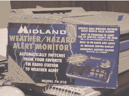 The safety of our children and senior citizens is very important. We must give them every chance to be prepared and survive the potential destruction caused by an approaching storm or weather system. For less than $50.00 a weather radio with S. A. M. E. technology can be purchased and placed in homes, daycare centers, schools, city offices, churches, fire stations and other buildings of high occupancy. This is a project that was started after getting the idea during the National Hurricane Conference in April of 2000. I began contacting local businesses in Santa Fe for commitments in donating S. A. M. E. type weather radios to the local schools, day care centers and our Senior Day Care Center, "Barbara's House". There were a total of twelve weather radios required to cover the five main school buildings, six major day care centers and Barbara's Day Care Center for Seniors. The project will be completed once the presentation has been made to representatives of the school and daycare centers.
The radios were provided by Farmers Mutual Protective Association, Temple, Texas, Santa Fe Lodge 3, Reitmeyer State Farm Insurance, Santa Fe Car Care, and Remax 1st Choice and Monica Atwood.
Sam's Club has the Midland Model 74-210 for $49.95.

Often in Southeast Texas, the most active season for severe weather is the collection of the spring months of March, April, and May.
With warm, moist air returning from the Gulf of America and active frontal systems from the north and west, the Upper Texas Coast and Southeast Texas often experience numerous showers and thunderstorms.
There are mainly two big weather phenomena during the spring-thunderstorms and tornadoes. Tornadoes are associated with thunderstorms, but not every thunderstorm is capable of producing a tornado. However, thunderstorms can still produce significant damage without the presence of tornadoes. By definition, a thunderstorm produces lightning which is the number two weather related killer in the United States. The number one killer is flash floods which are also associated with thunderstorms. Despite the popularity or notoriety of hurricanes and tornadoes, the two main weather related killers can occur on a frequent basis. There are ways to help reduce the chances of suffering injury or damage during thunderstorms.
The best defense for spring thunderstorms is preparation. Try to keep updated to forecasts that might suggest severe weather. There are several signs that suggest a thunderstorm approaching. Thunder is often the best warning signal. Temperature changes and breezy winds also offer a clue to approaching weather. If you can hear thunder or feel cool breezes, you are close enough to the thunderstorm to be affected. If at all possible, take shelter in a sturdy building away from windows. Use phones only in case of an emergency. If a shelter is not available, find a hard top automobile and keep the windows up. A common myth about automobiles is that the rubber tires insulate the car. This is false as lightning can still strike the vehicle. But the vehicle will provide significantly more protection than the open ground. Stay away from towers, hills, and tall trees as objects protruding into the air are the ones most likely to be struck. The only time to move to higher ground is if flood waters have been seen or reported in your area. If at the lake or on the coast, get off and away from water. If caught in the open ground, find a low spot in the terrain away from trees and fences. Squat low to the ground and lean on the balls of your feet. As lightning strikes the ground, it often spreads in several directions and can strike any object in the vicinity. By eliminating the area of ground that your are in contact with, you minimize your chance of being struck. If at all possible, stay informed by listening to advisories from commercial radio and television or to the National Weather Service's weather radio. With proper information and preparation, you can reduce the damage of severe thunderstorms to you, your family, and your property.
Tornadoes offer different problems, but many safety rules from thunderstorms apply. The best defense is again preparation. Practice tornado drills so that all members of the family or employees of business know the appropriate locations of tornado shelters. Don't panic. Move to an interior room away from windows. If at all possible cover yourself with blankets, pillows, or other soft objects. If driving, find a suitable low spot on the ground as quick as possible and abandon your vehicle. Do not try to outrun a tornado. If you reside in a mobile home, leave and find appropriate shelter as mobile homes offer little, if any, protection from tornadoes. Stay informed with the changing weather conditions.
By following these basic rules one can minimize the risk, and thus the damage, posed by the variety of spring severe weather over Southeast Texas.
| DEFINITIONS | |
|---|---|
| Tornado Watch | Conditions are favorable for the development of tornadoes (tornadoes are possible in the area) |
| Severe Thunderstorm Watch | Conditions are favorable for the development of severe thunderstorms (severe thunderstorms are possible in the area). |
| Tornado Warning | Tornadoes are imminent or are occurring in the area. |
| Severe Thunderstorm Warning | Severe thunderstorms are imminent or are occurring in the area |
At the annual meeting of the American Meteorological Society in Albuquerque, N.M., retired Brig. Gen. Jack Kelly, director of the National Weather Service, said the agency has proposed a multi-year initiative to expand the existing Cooperative Weather Observer program and upgrade the equipment that volunteers use to monitor precipitation and other weather data.
"For some time, our observers have supported us, despite substandard equipment," Kelly said. "Using funds we received in FY 2001, we will be able to start replacing some of this outdated equipment. But the modernization initiative is a broader plan that will need additional funds if we are to maintain the viability of this important program."
"The Weather Service couldn't get along without the cooperative observers," Kelly said. "It's important to recognize that even with our sophisticated technology, satellite data, remote sensing systems and the supercomputer, people are still the key factor in providing accurate and timely weather forecasts."
The Cooperative Weather Observer Program dates back to the times of Thomas Jefferson and Benjamin Franklin, and currently has more than 11,700 volunteers. These dedicated volunteers provide surface observations that are key in improving short term weather forecasts, and give early warning of severe weather events. This program also provides the only national source of temperature and precipitation data essential to accurate weather forecasts and the development and verification of U.S. climate prediction models.
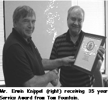
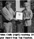
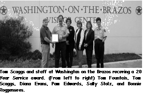
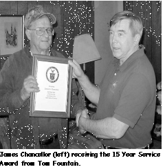
In our area, we are fortunate to have a number of these very dedicated observers. Erwin Knippal, for example, has taken observations in Columbus for over 35 years and Thomas Scaggs at Washington State Park for over 20 years. Paul Martinez of Conroe, James Chancellor of Alief, and Justin Carraway of New Caney have been taking observations for over 15 years. James Kellogg of Cypress and Helen Ciulla of North Houston have volunteered for more than 10 years. But, even those who have just recently become volunteers are important to us, and each of their observations is important. We believe, as General Kelly does, that "The Weather Service couldn't get along without the cooperative observers."
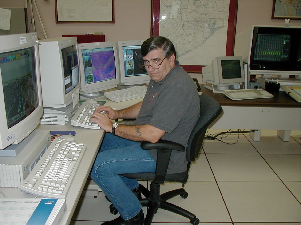 Name: Mike Kennedy
Office: NWS Houston/Galveston (HGX), League City, TX
Position: Electronic Systems Analyst (ESA)
Favorite Movie:
Personal Info
Hometown: Smithville, Texas
Other: Married (10 years!), 5 kids, 4 grandkids
AF/NWS Background
1969-81 United States Air Force (enlisted in Los Angeles, CA)
1981-90 US Air Force Reserve; Bergstrom AFB, Austin, TX
1990-92 Electronic Technician: NWSO Medford, OR
1992-95 Electronic Technician: NWSO Galveston, TX
1995- present Electronic Systems Analyst, NWSFO Houston/Galveston, TX
Duties
What was your most memorable weather event?
A blizzard back in 1977 while stationed at Grissom AFB (in Indiana). We were snowed in for a week.
What is the most challenging aspect of your job?
Putting up with Gene! No really, it is learning the new operating systems. It seems that every time I turn around, there is something new to learn. Since I have been here (at HGX), we have gone from DOS to LINUX!
Any retirement plans?
Living in the woods, playing with my chainsaws, and riding my tractor.
Tornadoes are the shortest lived and most unpredictable of violent storms. Nearly 800 tornadoes hit the U.S. yearly, most of those in a strip including parts of Texas, Oklahoma, Kansas and Nebraska known as "Tornado Alley," as well as other areas of the Midwest. The largest and most damaging rash of tornadoes in history, the "Super Outbreak," occurred April 3 and 4, 1974, with 148 twisters in the Midwest and even in the western part of five eastern seaboard states. Winds in at least six of the tornadoes whirled faster than 261 mph, making them F-5 storms on the Fujita Scale; and some were among the strongest ever recorded. |
The National Severe Weather Workshop will feature the nation's premier severe weather experts discussing their latest research and forecasting techniques. Speakers will include forecasters and researchers from the NOAA Weather Partners in Norman: Storm Prediction Center, National Severe Storms Laboratory, Warning Decision Training Branch, Radar Operations Center and National Weather Service Norman Forecast Office. Spotter training will be offered in conjunction with the workshop. Designed for emergency managers, storm spotters and other weather enthusiasts, the Friday afternoon and Saturday workshop offers a unique opportunity to learn about the National Weather Service's outlook, watch and warning process, severe weather preparedness and safety, StormReady, EMWIN, severe storm risks, lightning effects, wind damage effects and new ways to get radar data. Registration includes a Friday reception and Saturday luncheon.
For additional information go to following web page:
http://www.nssl.noaa.gov/nsww2001/nswworkshop.html
|
Locating Weather & Climate Records
All weather and climate data gathered by the National Weather Service, military services, Federal Aviation Administration, and Coast Guard is kept at the National Climatic Data Center in Asheville, North Carolina. The NCDC compiles the weather data (temperatures, precipitation totals, heating and cooling degree days, and more) collected from thousands of sites in the U.S. Records kept by local National Weather Service offices are forwarded to the NCDC on a regular basis, but you can expect a lag of 2-4 weeks before today's data is on file at the NCDC. |

