
STORM SIGNALS
Fall 1997, Vol. 46
CONTENTS

This edition of Storm Signals was printed by Dupont Coastal Severe Weather Alert Team as a service to the citizens of Southeast Texas and the Upper Texas Coastal Area.
HOW WILL EL NINO AFFECT WINTER IN SOUTHEAST TEXAS?
By Gene Hafele
We are observing one of the strongest El Nino's in history develop in the eastern tropical Pacific Ocean. The term El Nino, derived from the spanish word for "Boychild", is the cyclical warming of sea surface temperatures in the eastern equatorial Pacific waters. The effects of varying warmer water temperatures in the Pacific have significant impacts on short-term global climate, including weather patterns across North America. Mid and upper level westerly shearing winds increase over the tropical Atlantic as a result of El Nino, thus inhibiting tropical cyclone development across the Atlantic hurricane basin. August and September 1997 have been the least active since the 1929 season when only one storm formed during the months. An enhanced southern branch of the jet stream often results in increased precipitation across the southern tier of the United States.
If past history is any indication of what is in store for Southeast Texas this winter, we should be prepared for a wet yet relatively mild winter. Statistics for the winters of the last four El Nino events are listed below. The data is for the period from October thru March for each of the winter seasons.
Year	    Avg Low /	Avg High / 	Precipitation /
	    departure	departure	departure

1982-83	    47.7 / +.07	67.8 / -1.6	30.28 / +9.60
1986-87	    48.6 / +1.6	67.7 / -1.7	26.76 / +6.08
1991-92	    49.8 / +2.8	70.2 / +0.8	36.91 / +16.23
1994-95	    52.1 / +5.1	71.4 / +2.0	29.8 / +9.12
The current long range outlook for Southeast Texas issued by the Climate Prediction Center is indicating a cooler and wetter winter for much of South Texas including Southeast Texas. There are many sites on the Internet that can provide additional data on the current El Nino event. Listed below are a few of the NOAA homepages dealing with El Nino.
| http://www.cdc.noaa.gov/ |
| http://www.ogp.noaa.gov/enso/ |
| http://nic.fb4.noaa.gov |
| http://www.pmel.noaa.gov/toga-tao/el-nino |
Tornado Outbreak in Southeast Texas on October 23
By Gene Hafele
 Eleven separate tornadoes touched down on October 23 in southeast Texas. Many of thesetornadoes were spawned from the s ame supercell. Every tornado that formed had a tornado warning in effect before the damage was produced. Average lead time was 24 minutes between tornado warning issuance and tornado touchdown, ranging from 4 minutes to 58 minutes. No deaths occurred and only one injury was reported.
Touched down at 2:00 PM in Sugarland. The tornado was mostly F0 with some F1 damage. The tornado path length was 3 miles long and 1/4 mile wide at its strongest stage. Over 1 million dollars in damage to homes.
At 3:22 PM a tornado touched down in northern Walker County near Hwy 75. This tornado destroyed one home and heavily damaged a second. This was an F1 tornado with a path length of 2 miles and 50 yards wide.
At 3:32 PM the same supercell that produced the tornado at Sugarland spawned a second tornado near Crosby. The tornado first touched down on the east shore of Lake Houston and moved northeast into extreme western Liberty County. This tornado was mostly F0 and F1 with some F2 damage at Foley Rd and Dallas Rd where a boat house was severely damaged. An 18 wheeler in the same area was turned over and moved 50 feet by the tornado. This tornado was on the ground for 12 miles and the damage path was 1/4 mile wide at its strongest stage. This storm lifted around 3:56 PM in western Liberty County.
At 3:43 PM, a new supercell spawned a short lived tornado south of Bellville in Austin County. Only trees were damaged by this tornado.
At 4:07 PM the Crosby tornadic thunderstorm spawned a short lived tornado near Kenefick. This tornado was on the ground for less than 2 miles. Damage was mostly to trees and some minor roof damage. This was an F0 tornado.
At 4:25 PM another tornado was spawned by this same supercell. This F0 tornado was short and narrow and damage was confined to trees.
At 5:00 PM an F2 tornado touched down southwest of Midway in Montgomery County. This was probably the most significant in strength and length that occurred this day. The tornado was on the ground for 25 miles and the width of the damage was 1/4 mile at its strongest point. Several homes and mobile homes received major damage. A young boy was injured in a mobile home when the tornado picked up the home and wrapped it around a tree completely destroying it. Damage to trees was extensive with many trees being snapped off above the ground. This storm was surveyed from the air and had continuous tree damage from Midway to south of Shepherd in southern San Jacinto County. This tornado lifted back into the parent thunderstorm around 5:25 PM southeast of Shepherd.
At 5:15 PM an F0 tornado touched down in the Bear Creek Community in San Jacinto County. This tornado was the result of the Midway tornadic thunderstorm splitting and the left moving storm moving over Bear Creek. Damage was mostly to trees but a volunteer fire department building was also heavily damaged. Path length was less than 2 miles long.
A new supercell spawned a short lived tornado over Conroe with flag poles at the Conroe High School Football Stadium bent over. As the storm passed just south of Conroe Airport the ASOS recorded 57 mph winds from the south. This was an F0 tornado and touched down at 5:22 PM.
The supercell that spawned the tornado at Conroe spawned a second tornado along Hwy 105 near Cut-N-Shoot at 5:30 PM. This tornado moved along Hwy 105 with a path length of 4 miles. This was an F1 tornado with damage to homes, businesses and a school. This supercell continued moving east and followed much the same path as the earlier tornado that started near Midway. It is possible this supercell produced another tornado across eastern Montgomery County into southern San Jacinto County but it would be difficult to distinguish between the two storms. This storm lifted at 5:40 PM.
The above supercell did eventually produce one more tornado in Polk County. An F0 tornado touched down near Segno and moved northeast to near Dallardsville and continued northeast to near the Polk/Tyler County line. This tornado touched down at 6:35 PM and stayed on the ground for 15 minutes.
For more information on this tornado outbreak, access the following internet address:
http://www.srh.noaa.gov/hgx/projects/oct23_97.htm
NEW NOAA WEATHER RADIO ON THE AIR IN BAY CITY
By Gene Hafele
...NOAA Weather Radio comes to Matagorda and surrounding counties region...
 Wednesday, November 5 marked the official beginning of the NOAA Weather Radio (NWR) program for Matagorda and surrounding counties. The National Weather Service in cooperation with the Lower Colorado River Authority are pleased to announce an expansion of the NWR service into this area.
Because of the absence of NWR across Matagorda and surrounding counties the Lower Colorado River Authority officials have purchased a NWR transmitter and donated broadcast tower space to allow the National Weather Service to better serve this portion of the upper Texas coast. "This service offers residents of Matagorda and surrounding counties greater opportunity to protect life and property during weather emergencies," stated Bob Rose, meteorologist for the Lower Colorado River Authority.
The Bay City NWR transmitter, identified as WWG-40, will operate on a frequency of 162.425 mhz with a power of 1000 watts and serve Matagorda, Brazoria, Fort Bend, Wharton and Jackson counties along with Matagorda Bay and adjacent coastal waters.
The broadcast will originate from the Houston/Galveston National Weather Service Office located in League City. The Bay City transmitter is located on a tower just west of Bay City provided by the Lower Colorado River Authority. The Houston/Galveston National Weather Service now operates four NOAA weather radio stations: Galveston (162.55), Houston (162.40), Bryan/College Station (162.55) and now Bay City (162.425).
NWR provides continuous broadcasts of the latest weather information directly from the National Weather Service. Recorded messages are repeated every four to six minutes and are routinely revised every one to three hours...or more frequently if needed. The broadcasts are tailored to the weather information needs of citizens within the transmitter service area.
During severe weather, National Weather Service personnel interrupt the routine weather broadcasts and substitute special warning messages. They can also activate specially designed warning receivers. Such receivers either sound an alarm indicating that an emergency exists, alerting the listener to turn the receiver up to an audible volume or when operated in a muted mode, are automatically turned on so that the warning is heard. "Warning Alarm" receivers are especially valuable for schools, hospitals, public safety agencies and news media offices.
NWR is the designated sole government-operated radio system to provide direct warnings into private homes for both natural disasters and nuclear attack. This capability supplements warnings by sirens and by commercial radio and TV.
NWR broadcasts are made on one of seven high-band fm frequencies between 162.400 mhz and 162.55 mhz. These frequencies are not found on the average home or car radio now in use. However, a number of radio manufacturers offer special weather radios to operate on these frequencies, with or without the emergency warning alarm. Also, there are radios on the market which offer standard AM/FM frequencies plus the so-called "weather band" as an added feature.
NOAA weather radio broadcasts can generally be heard up to 40 miles from the transmitter site, depending on the height of the antenna, terrain, quality of the receiver and type of receiving antenna. As a general rule, listeners beyond the primary range would need a very good receiver system for reliable reception. Also, an outside directional antenna might be required in these fringe areas. If practical, a receiver should be tried at its place of intended use before making a final purchase. Receiver prices start around $20. Models with warning alarm start between $35 and $50.
The National Weather Service is pleased to be able to provide NWR service to many of the citizens in the Matagorda and surrounding counties region. Please take advantage of this service and tell your friends and neighbors about NOAA weather radio.
1998 SKYWARN
By Gregg Waller
Winter is bearing down and Spring is just around the corner. With Spring comes Spring severe weather. Are you willing to help? If so, are you unsure how you can help? Skywarn 1998 is the perfect opportunity. Now is the time to schedule a Skywarn Program for your group or organization. The Skywarn 1998 program will have new slides, new video, and possibly a new slant to teach both the "first-timers" and the "old pros" everything needed to know to help the National Weather Service, and ultimately your community.
Skywarn is a program sponsored by your National Weather Service Office in conjunction with your local Emergency Management Organization. It is a group of trained volunteers that watch the skies during severe weather and relay reports back to the local Emergency Management Official, the local Sheriff's Department, and/or the National Weather Service. These volunteers provide valuable information to the National Weather Service which helps improve the warning program, thus possibly saving lives and property in the community.
The Skywarn 1998 program will help the individual identify the varying types of thunderstorms (single cell...multi-cell cluster...multi-cell line...and the super cell) and what type of severe weather to expect from each type of thunderstorm. But of more importance...you will learn what valuable information should be passed on to the National Weather Service and/or your local Emergency Management Official.
If you or your community is interested in sponsoring a Skywarn Program, now is the time to reserve your training session. The Houston/Galveston National Weather Service will be conducting Skywarn classes during the months of January, February, and March to help the Skywarn Spotters be prepared for the 1998 Spring Severe Weather season. The training sessions last around three hours and can be scheduled during the day...in the evening...or even on Saturday to best meet you or your group's schedule.
If your group or community is interested in sponsoring a Skywarn Program in early 1998, please make your reservations now. Call Gene Hafele at 281-337-5074 between the hours of 8:30 AM and 4:30 PM Monday through Friday. Regardless of past history, Mother Nature can always throw a curve. We must be prepared for any severe weather outbreak.
Interesting Marine Weather Tidbits
(July through Setempber 1997)
By Robert Van Hoven
July
On the 5th, strong thunderstorms 3 nautical miles northwest of Smith Point produced gusty winds in excess of 35 knots. Late afternoon on 14th, a cluster of strong to severe thunderstorms moved rapidly southwestward across Galveston Bay and into the coastal waters of Galveston and Chambers counties producing gusty outflow winds up to 50 knots (as indicated by PORTS*). Several barges were pushed to the western fringes of the Houston Ship Channel by strong northeasterly wind gusts. Early in the afternoon of the 30th, the Coast Guard reported a waterspout in east Bay about 10 nautical miles east of Texas City.
August
On the morning of the 8th, Texas City Police Department personnel spotted waterspouts and funnel clouds over Galveston Bay near Texas City and also over Snake Island. Early in the evening of the 22nd, strong thunderstorms moved from Chambers County to East Bay and Bolivar Peninsula. The storms weakened but redeveloped again once reaching the immediate coastal waters just southeast of the Galveston channel entrance.
September
Late afternoon on the 2nd, a severe thunderstorm over the upper end of Trinity Bay moved westward producing zero visibilities in very heavy rain, and gusty winds in excess of 30 knots. On the 3rd, a severe thunderstorm approximately 10 nautical miles southeast of Palacios moved southwest across Matagorda Bay. Then again the next day, in the early afternoon, a severe thunderstorm producing small hail moved across the eastern part of Matagorda Bay. A cold front with associated strong to severe thunderstorms traversed Southeast Texas during the late afternoon and early evening hours of the 9th. The storms affected Galveston and Matagorda Bays, and the upper Texas coastal waters. Outflow winds from the thunderstorms produced gusts in excess of 30 knots. PORTS* at Eagle Point indicated 38 knots at 724 PM. Late afternoon on 11th, a thunderstorm with a history of producing large hail moved across the eastern portion of Matagorda Bay.
*PORTS (Physical Oceanographic Real-Time System). For further information, call Captain Stephen F. Ford of TAMU Galveston at (409) 740-4471
NOAA Weather Radio's with SAME Technology now available to Consumers
By Gene Hafele
 A new radio capable of receiving local National Weather Service broadcasts gives consumers the best possible means of hearing local severe weather warnings any time of the day or night.
NOAA Weather Radio, the "Voice of the National Weather Service," broadcasts official NWS warnings and hazard information and local forecasts 24 hours a day. Routine forecast information is updated every one to three hours, and NOAA Weather Radio broadcasts are repeated every five minutes or so.
A new generation of programmable NOAA Weather Radio receivers now on the market have a special feature that allows consumers to choose only the official watches and warnings that affect their county area and screen out any warnings issued for other counties within the typical 40-mile broadcast range of the NOAA Weather Radio transmitter.
Using digital technology known as Specific Area Message Encoding (SAME), all official watches and warnings issued by the NWS over NOAA Weather Radio are preceded by unique audio codes that describe the type of warning and identify the county or counties being warned. People who own this new SAME-capable receiver can pre-select their local codes to ensure they hear the specific warning information they need to make potentially life-saving decisions. These new NWR receivers are currently available in Radio Shack Electronic Stores and will soon be available in other electronic stores across the area.
Older NOAA Weather Radio receivers are not affected by the technology change, but these older receivers do not allow listeners to take advantage of the SAME capability to screen out Weather Service alerts for individual counties.
Since the 1950s, the National Weather Service has broadcast weather forecasts and severe weather warnings free to the public over our network of very high frequency radio transmitters. Following a tornado that killed more than 20 people in a rural Alabama church on Palm Sunday 1994, Vice President Al Gore set a goal to extend the coverage provided by the NOAA Weather Radio transmitter network to 95 percent of the U.S. population. The National Weather Service and other members of the Gore task force are promoting public/private sector partnerships to provide the needed resources. Since 1994 the NOAA Weather Radio network has added more than 50 new weather radio transmitters: many are the result of grass roots partnerships combining resources of private enterprises, associations, and local, state and federal government agencies. In southeast Texas a new weather radio was recently installed in Bay City to cover Matagorda and the surrounding counties.
The broadcast range for most NOAA Weather Radio transmitters is approximately 40 miles. The effective range depends on terrain, quality of the receiver, and indoor/outdoor antennas. The Houston/Galveston National Weather Service currently operates four NOAA Weather Radio stations in southeast Texas. They are Houston, Galveston, Bryan/College Station and most recently Bay City in Matagorda County. Attached is a list of these Weather Radio Stations, their frequencies and the county codes needed for the SAME receivers. For a list of additional frequencies and transmitter locations, and to look up the specific SAME codes check the NOAA Weather Radio website-- http://www.nws.noaa.gov/nwr.
Our staff at the Houston/Galveston National Weather Service office is excited about how this new technology can benefit anyone within range of a NOAA Weather Radio transmitter. We encourage people to get their own NOAA Weather Radio receiver, and help us move closer to our goal of someday having a NOAA Weather Radio in every home, and in all schools, hospitals and other public gathering places. For additional information concerning this new technology, feel free to contact our office.
Flooding...A Serious Weather Threat
By Charles Roeseler
Flooding can be caused by a variety of weather events across southeast Texas. Rainfall intensity, duration, topography, soil conditions and urbanization all contribute to the type, severity and duration of the flood event. Severe thunderstorms can produce heavy rain in a short period of time transforming benign creeks into raging torrents of death and destruction. Flooding which occurs within 6 hours of the rain event is defined as flash flooding. The term flooding refers to a longer term event lasting for a period of days. Hurricanes and tropical storms can flood coastal areas with the destructive and deadly storm surge. Heavy rain associated with these storms will add to the flooding problem. Although the storm surge will affect coastal sections only, the tropical rains can flood areas hundreds of miles from the coast.
Flooding can occur during any time of the year...day or night. Although flooding does not receive the dramatic publicity associated with tornadoes or large hail, it is far more destructive and deadly. The potential for longer lasting consequences are greater with flooding events than other weather phenomena. Flooding causes more damage to agriculture and commerce than any other weather related event. More people lose their lives during flood events than any other meteorological episode. Seventeen people lost their lives in the October 1994 flooding event which occurred over southeast Texas.
Flooding can be deceptive. It is easy to misjudge the depth of a water covered roadway or the current of a rapidly rising stream. Darkness further complicates the judgement process by hiding road damage or debris. Remember...flood waters are usually deeper and flowing faster than they appear. This is especially true at night when darkness reduces visibility.
The National Weather Service will issue many statements during or in advance of a heavy rain or potential flood situation. The following is a list of statements to listen for:
Here are some safety tips which if implemented will reduce the risk of death and serious injury.
The danger from flooding can be managed if you heed safety tips and stay informed of current weather information and warnings. Monitor NOAA weather radio or other reliable news sources when the weather appears threatening.
EMERGENCY MANAGEMENT WEATHER INFORMATION NETWORK (EMWIN)
By Jim Robinson
Harris County Appraisal District
EMWIN is a low cost, low speed, data stream that is available via VHF radio broadcast in the Houston area today. The EMWIN data is being rebroadcast on 150.435 MHZ as a public service by the Harris County Appraisal District. The broadcast originates from loop 610 and hwy 290 from atop a 175 foot tower at 50 watts power output. The broadcast range is 30-40 miles from the transmitter site. To receive the data you need a VHF receiver capable of receiving 150.435 MHZ, a demodulator and a computer with Weathernode Software. Software and demodulator can be purchased from vendors for less than $200.
The Houston EMWIN broadcast, while one of the more recent in the nation to come on-line, may be among the most sophisticated in terms of local interest graphics being added to the data stream.
EMWIN is processed by the Harris County Appraisal District's Information Systems Department, which uses its T1 connection to the Internet to retrieve and insert a variety of graphics including composite radar images for both Southeast and North Texas, a manually digitized radar map of the United States, and a surface weather depiction chart centered on Texas. The Southeast Texas radar composite is currently updated twice hourly, with a change to three updates per hour planned for the near future. The other graphics are updated once each hour.
In addition, the Harris County Office of Emergency Management's 24 hour rainfall map is inserted and broadcast daily shortly after midnight. The appraisal district's computer center automatically processes the data using two different servers. One machine handles image retrieval and insertion, while the second receives data from Goes 8 and prepares the Houston broadcast with software which assigns priorities to each product depending on its urgency. The data then moves on a dedicated telephone circuit to the transmitter site at US 290 and Loop 610.
Both the computer center and transmitter site have emergency power available, thus assuring continued coverage during severe weather situations. The Houston broadcast may be received on 150.435 MHZ . For best reception, an outside antenna may be required at distances of 10 miles or more beyond the transmitter location.
Additional information about the local EMWIN broadcast may be obtained by sending e-mail to EMWIN-Houston@hcad.org.
For information concerning EMWIN in general there are several Internet addresses that can accessed for additional information.
EMWIN Information:
http://www.nws.noaa.gov/oso/oso1/oso12/document/wintip.htm
NWS EMWIN:
http://iwin.nws.noaa.gov/iwin/main.html
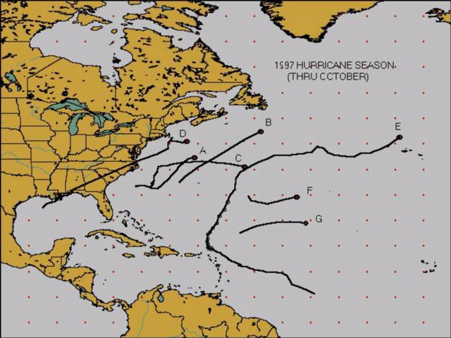
1997 Hurricane Season
by Joshua Lichter
As the 1997 Atlantic hurricane season winds down, we have some interesting historical statistics for the Texas coast concerning tropical cyclones. Recent inactivity from Brownsville to Beaumont is approaching record breaking levels.
Through the end of October, seven named systems have developed in the Atlantic basin. Tropical Storm Ana, Hurricane Bill, and Tropical Storm Claudette all formed in the Atlantic Ocean off the east coast of the United States. Hurricane Danny formed south of Louisiana and moved to the northeast across the southeastern states and off the middle Atlantic coast into the Atlantic Ocean. Hurricane Erika, the strongest system this season, formed half way between the Lesser Antilles and the west coast of Africa, moved to the west northwest passing just north of the Virgin Islands, and recurved out into the Atlantic Ocean. Tropical Storms Fabian and Grace formed in the far eastern Atlantic Ocean, both barely exeeding minimal tropical storm status.
An average Atlantic hurricane season has 10 named systems - 6 of which become hurricanes (two of these reach category 3 or higher on the Saffir-Simpson scale). The 1997 season has seen 3 hurricanes (only one, Erika, reached category 3 or higher status) and 4 tropical storms.
The two months of August and September 1997 brought something very rare to the Atlantic basin. Only one named tropical cyclone, Erika in September, occurred in this two month period (August had no tropical cyclones). The last year when only one tropical storm or hurricane formed in the month of September was in 1946 - more than half a century ago. Between 1946 and 1996, every year had at least two (sometimes as high as seven) tropical storms or hurricanes form in the month of September. Not since 1929 has the Atlantic basin experienced only one formation in the months of August and September combined.
If no hurricanes come across the Texas coast for the remainder of this season (a hurricane has never done this in the month of November since records began in 1880), eight years will have passed since our last hurricane visit (Hurricane Jerry in October 1989). This will equal the longest period (1972 to 1979) without a landfalling hurricane.
It is still way too early to tell, but if Texas does not get a hurricane landfall by the end of the 1998 season, this all time record will be broken.
The COOP-NEWS CORNER
By Tom Fountain
The first signs of fall are all around us. Sunset is earlier, the mornings are cooler, and the leaves are beginning to change color. This will get Max and I on the road to visit the different stations and get the ROSA system off the ground. We have changed a few stations over the past month where repairs were needed. We will be trying to change the remainder of the stations before the end of the year.
There will not be any big change with the coming ROSA system for most. The biggest change will be for the stations with MMTS. We will be asking you to enter in your max and min temperatures on a daily basis. I realize this is a little more work on your parts. However, this is an opportunity for you to help improve the forecast for your area. It is one of those historic leaps for weather, as no others in history have had an opportunity to use so much data in near real time as a forecasting aid.
Max continues to remind me that we need to get the B-91 forms in as soon as possible after the end of the month. This is really a critical part of the program, we go through these to make sure there are no big errors (data in the wrong column, headings filed out, etc.). Then we bundle these and send them to the National Climatic Data Center in Asheville, NC where they are put into the computer for publication. The problem comes when a report is too late for publication, this leaves a blank spot for that month, which makes it hard for a person trying to do a weather research project for the area. So, please make sure your data gets in as soon as possible after the end of the month. This will also help keep Max and I out of trouble. Thanks!

HOUSTON CHAPTER OF THE AMERICAN METEOROLOGICAL SOCIETY
By Robert Van Hoven
The meeting on Thursday, September 18 was quite successful with a good number of members and guests attending. The meeting was held at the City of Houston's Bureau of Air Quality Control Office. Our guest speaker was Gene McMullen. Gene has worked for the Bureau of Air Quality Control for over two decades. He explained how the concept of air quality control developed through the years. Among other things, he showed us air pollution trends in Texas cities during the last 10 years, ozone monitoring data since 1972, and daily peak ozone concentrations for some Texas cities including metropolitan Houston. Interestingly, he showed us (filter trapped) fine sand samples transported by high level winds from the Sahara desert to Houston.
The meeting on Thursday, October 16 was hosted by Frank Gutierez of Harris County's Emergency Management at the Trans-Star Building. Dr. John Freeman from the Weather Research Center was our guest speaker. He talked about El Nino/Southern Oscillation (ENSO) and its correlation with the Sun's orbit. He is developing a long term forecasting technique for ENSO episodes.
November's meeting will be on Thursday the 13th with Jim Price of TNRCC as our guest speaker. He will talk about the COAST Project. December's meeting will be at the Houston/Galveston National Weather Office in League City. We will have two staff members from the weather office as guest speakers. Kent Prochazka will talk about the capabilities of the WSR-88D, and Charles Roeseler will talk about his VIL density study.
For those of you interested in joining the Houston Chapter of the American Meteorological Society, contact Robert Van Hoven at the Houston/Galveston National Weather Service Office (281) 337-5074 (robert.vanhoven@noaa.gov). Remember - you do not have to be a meteorologist to join. All you need is an interest in meteorology. Annual membership dues are only $10 a year.

