 Model Guidance
| Site | NAM (MET) |
GFS (MAV) |
GFSX (MEX) |
One Stop MOS |
LAMP | LAMP Meteogram |
|---|---|---|---|---|---|---|
| IAH Intercontinental Airport, Houston |
|
|
|
|
|
|
| GLS Galveston, TX |
|
|
|
|
|
|
| CLL College Station, TX |
|
|
|
|
|
|
| HOU Hobby Airport, Houston |
|
|
|
|
|
|
| CXO Conroe, TX |
|
|
|
|
|
|
| EFD Ellington Field, TX |
|
|
|
|
|
|
| PSX Palacios, TX |
|
|
|
|
|
|
| UTS Huntsville, TX |
|
|
|
|
|
|
| LVJ Pearland (Clover Field), TX |
|
|
|
|
|
|
| VCT Victoria, TX |
|
|
|
|
|
|
| CRP Corpus Christi, TX |
|
|
|
|
|
|
| LFK Lufkin, TX |
|
|
|
|
|
|
| SAT San Antonio, TX |
|
|
|
|
|
|
| DFW Dallas/Fort Worth, TX |
|
|
|
|
|
|
| LCH Lake Charles, LA |
|
|
|
|
|
|
Understanding...
| ETA (MET) Guidance | GFS (MAV) Guidance | GFSX (MEX) Guidance | GFS LAMP (LAV) Guidance |
Model Graphics
| NSSL WRF 4 KM | SPC Forecast Tools |
| NCEP NAM Convective Forecasting | Model Analyses and Guidance (from NCEP) |
| HRRR (High Resolution Rapid Refresh) | Texas Tech WRF |
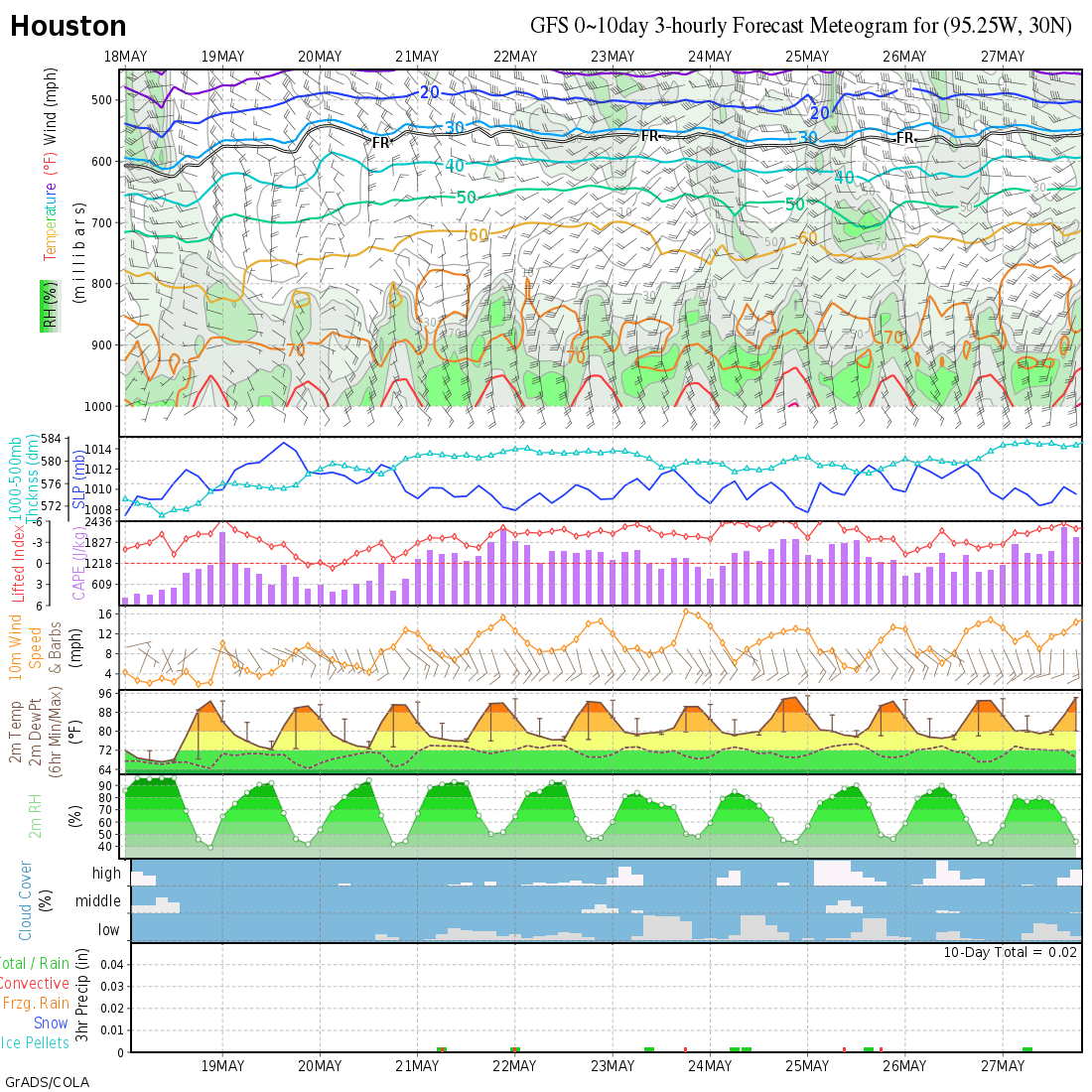
| Meteogram for IAH: NAM (0-84hr) | Meteogram for IAH: GFS (0-8 day) |
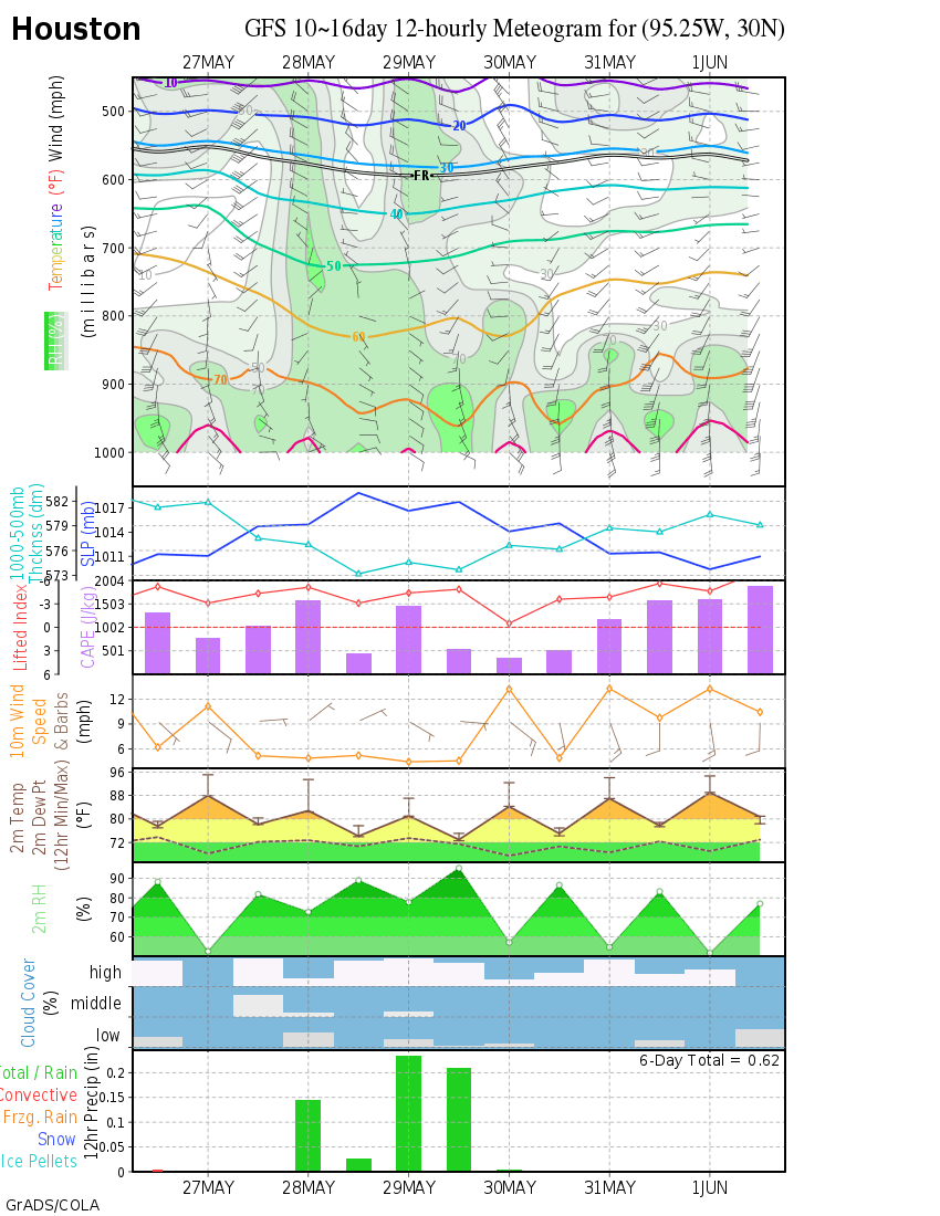
| Meteogram for IAH: GFS (8-16 day) | Meteogram: Other sites |
| Meteogram:Iowa State Meteogram | Meteogram Description |
| Model Analyses and Guidance (from NCEP) | SLU CIPS Analogs |
| e-WALL : THE ELECTRONIC MAP WALL | ENSEMBLES and Consensus Forecast Departure from Climatology |
| NCEP (NMC) ENSEMBLE Forecast Products | NCEP/HPC Interactive Model Bias Page |
| WRF NMM - 00z - 06z - 12z - 18z | ECMWF - 00z - 12z |
Raw Data Plots/Soundings
| Real Time Wind Profilers | Near Real Time TX Surface Plot |
| Surface Analysis | Upper Air Data Plotter |
| Upper-Air Soundings (Soundings Help Page) | |
Localized Aviation MOS Program (LAMP)
| GFS-LAMP Forecast Bulletins (by state) | GFS-LAMP Analysis Images |
| Description of the GFS LAMP Alphanumeric Message | What is LAMP? |
BUFKIT Data (Model Forecast Soundings)
Learn more about the BUFKIT program and to download the application visit the NWS Warning Decision Training Branch BUFKIT Home Page.
Right click on a link then "Save link as" or "Save target as" to your local computer's BUFKIT data folder. This data is experimental and may not always be the latest model run. Be sure to check the date/time!
| Site/Model | WFO HGX WRF-ARW | RAP | GFS | NAM (00Z or 12Z) | NAM (06Z or 18Z) | SREF |
|---|---|---|---|---|---|---|
| Houston Hobby | KHOU | KHOU | KHOU | KHOU | KHOU | KHOU |
| Houston Bush Intercontinental | KIAH | KIAH | KIAH | KIAH | KIAH | KIAH |
| Galveston Scholes Field | KGLS | KGLS | KGLS | KGLS | KGLS | KGLS |
| College Station | KCLL | KCLL | KCLL | KCLL | KCLL | KCLL |
| Huntsville | KUTS | KUTS | KUTS | KUTS | KUTS | |
| Conroe | KCXO | KCXO | KCXO | KCXO | KCXO | |
| Angleton/Lake Jackson | KLBX | KLBX | KLBX | KLBX | KLBX | |
| Sugar Land | KSGR | |||||
| WFO HGX (Dickinson) | KHGX | |||||
| Crockett | KDKR | |||||
| Brenham | K11R | |||||
| Wharton | KARM | |||||
| Cleveland | K6R3 | |||||
| Bay City | KBYY | |||||
| Palacios | KPSX | |||||
| Caldwell | KRWV | |||||
| Johnson Space Center | KWNJ | |||||
| Pearland (Clover Field)l | KLVJ | |||||
| Ellington Field | KEFD | |||||
| Ratcliffe RAWS (32.4N 95.1W) | RTCT2 | |||||
| Coldsrping RAWS (30.5N 95.1W) | CPGT2 | |||||
| Attwater NWR | ANWT2 | |||||
| Anahuac RAWS (26.7N 94.4W) | TR474 | |||||
| Brazoria NWR | BZRT2 | |||||
| San Bernard RAWS | SRDT2 | |||||
| High Island 179A Oil Platform | KXIH | |||||
| Galveston 424 Oil Platform | KGVX | |||||
| Brazos 451 Oil Platform | KBQX | |||||
| High Island 376 Oil Platform | KHQI | |||||
| Houston Executive | KTME | |||||
| Houston Southwest Regional | KAXH | |||||
| Houston Hooks | KDWH | |||||
| S Tx Plant | S TX Plant | |||||
| Houston Dunn | KMCJ | |||||
| Houston (West) | KIWS | |||||
| Palestine Profiler | P#1 | |||||
| Texas City | TXCY | |||||
| Pasadena | PAS1 | |||||
| Lufkin | KLFK | KLFK | ||||
| Beaumont | KBPT | KBPT | ||||
| U of H Coastal Center | UHCC | |||||
| U of H Campus | UOFH |

