
A round of severe thunderstorms are forecast across areas of the Southern Plains, Mississippi Valley and Great Lakes this afternoon and tonight; The threat for flash flooding will also accompany these storms. The rainfall for the Great Lakes region could prolong the ongoing flooding. Where the rain is needed, the Southern High Plains, critical fire weather concerns through today. Read More >

Tropical Storm Allison developed from the remnants of Eastern Pacific Hurricane Cosme and a tropical wave. Based upon observations from offshore oil rigs and coastal surface data, a tropical depression formed on 6/24. It was upgraded to tropical storm status on the 26th based on a wind report of 35 knots with gusts to 45 knots from a ship, some 100 nautical miles northeast of the center. Allison moved inland over the mid Texas coast, near the northeast end of Matagorda Bay, with a central pressure of 1002 mb, but continued to strengthen slightly over the next 12 hours as the central pressure dropped to 999 mb on the 27th. Highest wind gusts in the Houston-Galveston area was 56 mph at the Galveston Weather Office on the 26th. There was one tornado (injuring one person) associated with Allison. It touched down on the Bolivar peninsula in the Gilchrist area and did minor damage.
Torrential rains accompanying Allison fell along the upper Texas coast and over the western two-thirds of LA. Nearly 30 inches of rain fell in a 6-day period at a few locations in north-central LA. 10 to 15 inches of rain just north and east of Houston extending eastward towards Beaumont produced major flooding in the area. The flood waters were very significant because previous flood waters from heavy rains in May had just abated. Flooding was worse in north and east Harris County and in southern Liberty and northern Chambers counties. The heaviest rainfall was to the right of where Allison made landfall. Over 10 inches fell in a 24 hour period over eastern Harris County eastward into Liberty and Chambers counties. Storm totals for four days ending on the 27th were close to 15 inches of rain in eastern Harris County. Actually, flooding from the tropical system began on the 24th when up to 5 inches of rain fell over southeast Harris County in the area around Hobby Airport and Deer Park. Major overbank flooding began on rivers and bayous in the area on the 26th and continued in the area through the first week in July. All rivers and lowlands in the area mentioned were flooded and waters were very slow to recede.
Storm surge heights produced from Allison on the Gulf side were 3 to 5 feet. Offshore seas were reported to be 10 to 16 feet. May tides were a maximum in the upper end of Trinity Bay near Baytown where 7 feet was measured.
The death total in Allison was 11, all attributed to drowning. Estimated dollar damage is near 1/2 billion dollars, due mainly to flooding.

Chantal was first detected on July 24th as a disturbance near Trinidad. Ships and satellites indicated that a tropical depression formed on the 30th. The depression became a storm on the 31st, when an Air Force Reconnaissance plane estimated maximum surface winds of 45 knots, while a ship reported a 50 knot wind on the east side of the storm center. Chantal continued strengthening while moving northwest toward the upper TX coast and was upgraded to a hurricane by August 1st. Chantal reached its peak, just prior to the center making landfall at High Island, TX with top winds of 70 knots and a tide of up to 7 feet. Thirteen deaths were attributed to Chantal and, just as in Allison, all were the result of drowning. Chantal's main effects were flooding, by torrential rains, and beach erosion.
Chantal's rains were the most significant feature of the hurricane as amounts of up to 12.1 inches officially and 20 inches unofficially were reported from locations in an east-west band about 20 miles south of downtown Houston and extending from Texas City to Rosenberg. The resultant flooding affected hundreds of homes across Southeast Texas. In addition to the flooding, beach erosion occurred along the coast in the High Island area, and although wind damage was relatively weak, numerous trees, power lines, fences and signs were blown down and some roof damage was done to homes, mobile homes, and carports. There were about 3,000 homes in Texas that had either water or wind damage. There were only two weak tornadoes spawned by Chantal that could be confirmed, one on Crystal Beach of the Bolivar Peninsula, and the other near Iota, LA. The total damage from Chantal was near $100 million.

Jerry originated from a tropical wave that moved across the tropical Atlantic and Caribbean Sea. There were no additional signs of organization before it developed into a tropical depression on 10/12 as it moved into the Bay of Campeche. The depression attained tropical storm strength on the 13th. After some hesitation, shearing and a temporary turn to the northeast, Jerry turned toward the north northwest on the 15th and strengthened to a hurricane. The hurricane made landfall on Galveston Island, near Jamaica Beach, in the evening on the 15th. No hurricane had ever made landfall on the upper TX coast so late in the season. Once inland, Jerry moved over eastern TX, weakened rapidly, and was absorbed by a frontal trough late on the 16th. Maximum sustained surface winds of 65 knots with gusts to 87 knots were measured at Scholes Field on Galveston Island as the eyewall passed over the airport. The observation site lost power near this time, and the observer-estimated maximum sustained winds reached 70 knots with gusts of 90 to 100 knots. An extrapolated minimum central pressure of 982 mb was reported by a NOAA aircraft and by an Air Force plane just prior to landfall. Jerry killed three people, all by drowning when their car was either driven off the Galveston seawall during a blinding rain, or was blown off by the winds.
Jerry's effects were considered minor. There was little wind damage, as the cyclone was of small size and its tropical storm force winds were restricted to a narrow band along its path. Also, Jerry weakened quite rapidly from its already minimal hurricane status after landfall; maximum winds reported at Houston's Intercontinental and Hobby airports were both less than tropical force. The highest tide, 7.0 feet, was reported at Baytown on Galveston Bay, although unofficial reports of an 8 foot tide were received from near the entrance to the Houston ship channel just west of Baytown. Rainfall was generally 2 inches or less in the Houston area, and between 2 and 5 inches eastward from Galveston Bay to the state line. There was one report as high as 6.40 inches from Silsbee. Also, Jerry spawned six tornadoes over Southeast Texas, but all six were momentary and rated as F0 in intensity as they produced little damage along their short path lengths.
Damage estimates for the hurricane were near $70 million. Damage mainly consisted of light beach erosion on portions of Galveston Island and the Bolivar Peninsula, and some flooding. The flooding was mostly of the coastal type produced by storm surge, or of the urban street type caused by sudden isolated downpours of heavy rain.

An unnamed tropical storm was quick to move inland shortly after forming in the northwestern Gulf of America on 8/9, and attained tropical storm status for only a few hours prior to its landfall near the TX-LA border. Only a few oil rigs reported sustained winds of 35 knots, and since it appeared the winds might be related to convection rather than the circulation at the time of the storm, the system was not upgraded or named. After-the-fact upgrading from subtropical to tropical storm status was based on a re-evaluation of wind data, the storm's tropical cloud pattern, and the tendency for the system to maintain itself with a spiral, bandlike structure for several days after its landfall. Rainfall amounts associated with this system averaged 3 to 7 inches, mainly in LA. The highest 24 hour rainfall total observed was 8.70 inches in Baker, LA. Widespread street flooding was reported in numerous LA parishes.

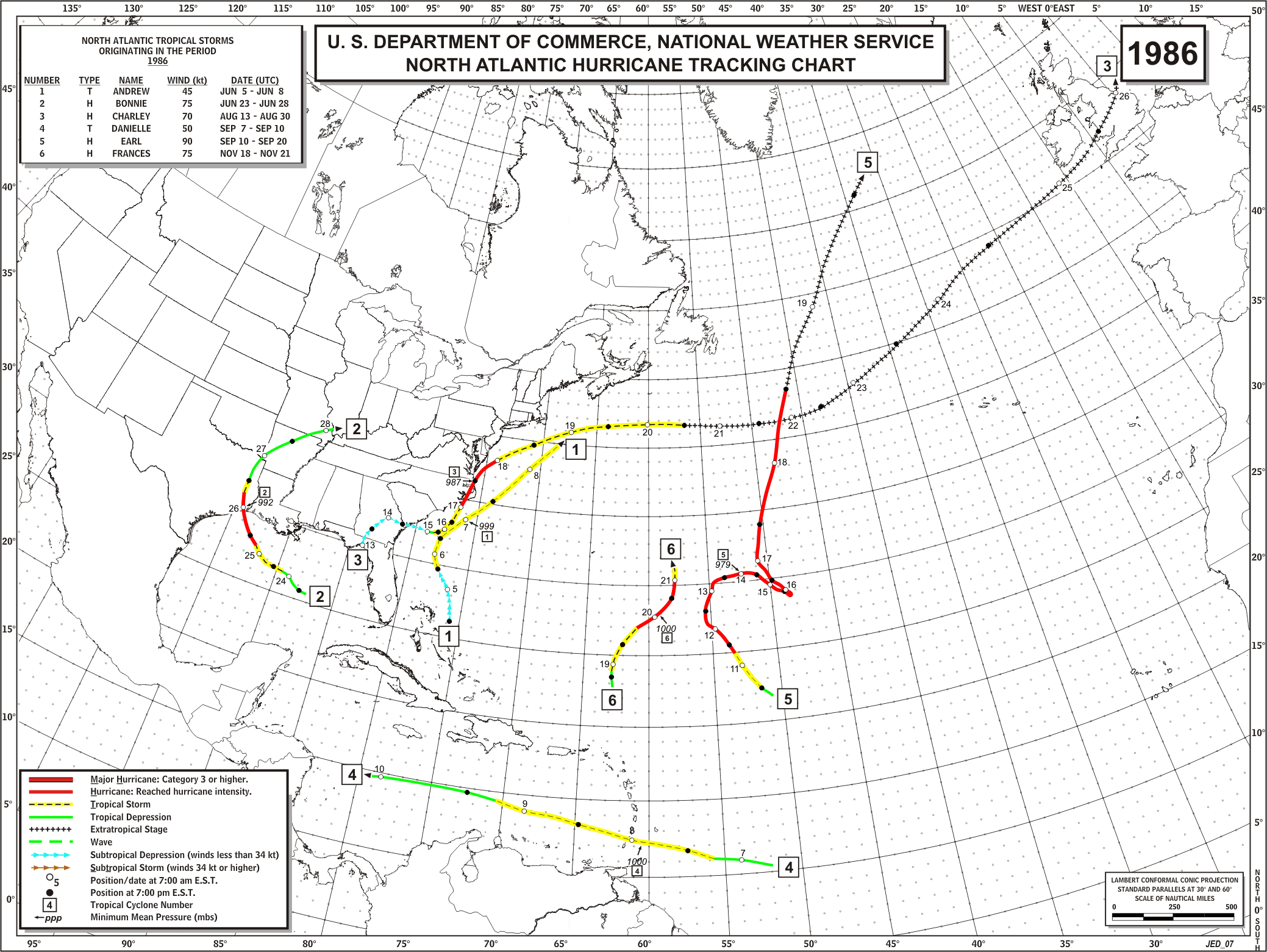
Hurricane Bonnie, the first June hurricane to affect the Texas coast since 1957, made landfall between High Island and Sabine Pass in the early morning hours of the 26th. Bonnie formed first as a tropical depression about 350 miles southeast of New Orleans, late morning on the 23rd. It intensified to tropical storm strength on the morning of the 24th. Hurricane strength was obtained on the morning of the 25th. The hurricane strengthened until having 97 mph winds and a central pressure of 992 mb (29.23 inches) at landfall. The 97 mph wind was recorded at Sea Rim State Park, and the peak gust at the Jefferson County Airport NWS office was 66 knots (75 mph).
While Bonnie caused no major structural damage, there was widespread minor damage and debris littered the streets of Port Arthur and Beaumont. The high winds broke out many windows, and downed countless trees, signs, fences, and tree limbs. Fallen trees damaged several homes. High winds ripped the roofs off of numerous homes and businesses. Many schools in the area suffered roof and wind damage. The high winds tilted over tractor-trailer rigs and flipped over smaller vehicles. Several aircraft were damaged at local airports. Power was out in most of the area as many utility poles were downed or leaning so that electrical lines were not functional. In Beaumont, high winds blew over the radio tower at the Texas Dept. Of Public Safety building. There were several reports of funnel clouds spotted, but no confirmed tornadoes. In Chambers County, high winds ripped the roof off of a mobile home near Winnie. Further inland, high winds on Sam Rayburn Reservoir, damaged boats and marinas, and the damage was estimate at near $1 million. There were many trees and power lines down in Tyler County.
Approximately 1,300 people were forced from their home from flooding that was produced by the torrential rains that accompanied Bonnie. The rains were the heaviest from the Beaumont area northwest to Lake Livingston. As much as 13 inches fell at Ace in southern Polk County. This heavy rain produced a runoff that resulted in a rise on the Mill and Menard Creek that flooded Bear Foot Lake and some homes surrounding the lake. The lake rose and the flood waters eroded part of the Big Thicket Lake Estate Dam. Below the dam, about 200 families were evacuated in fear that the structure would give way. There were no deaths or injuries from this event. Local flooding occurred in and around Bridge City where 7.5 inches of rain fell. Around six inches also fell near Kirbyville along the Jasper-Newton County line. Flooding closed several roads in the area. In San Jacinto County, flooding occurred along Big Creek which closed U.S. Highway 59 for several hours. In Hardin County, rains in excess of six inches fell on the headwaters of Pine Island Bayou and resulted in the flooding of hundreds of homes and businesses. Village Creek was flooded in Hardin and Tyler counties. There was overbank flooding of the Neches River in Tyler, Jasper, Orange, Hardin, Jefferson and Polk counties. Texas Highway 87 in Jefferson County was closed early on the 26th due to fallen poles and scattered debris.
The highest tide from the storm was 5.4 feet at Sabine Pass on the morning of the 26th. Tides were generally 3 to 4 feet on Bolivar Peninsula. The highest tide at Galveston was 2.2 feet on the evening of the 25th.
The effects of Bonnie on Harris and Galveston counties were trifle or nil. The peak wind at the Galveston WSO was 30 knots. At Alvin, the peak wind was 21 knots. Rainfall at both locations was 0.38 and 0.62 inches, respectively. An estimate 25,000 persons evacuated the upper coastal areas in advance of the storm.
There were no deaths that could be attributed directly to Bonnie. However, there were four related deaths (two in traffic accidents, one from a house fire, and one drowned while getting fresh water from a pond).

.
Alicia was the first hurricane to make landfall on the U.S. mainland since Hurricane Allen hit South Texas in August 1980. The three year and eight day period was the longest since 1886 that the continental United States had gone without a hurricane landfall.
After forming just south of Louisiana on the 15th, the storm drifted westward and intensified quickly into a Category 3 hurricane before making landfall on the west end of Galveston Island in the early morning hours of the 18th The highest winds recorded on land were 96 mph sustained, and gusts were up to 127 mph. The lowest barometric pressure recorded on land was 28.55" at the Alvin weather service office. Rainfall amounts exceeded 5 inches in most places, and the east side of Houston received almost 11 inches. The highest storm surge was a 12' reading at Seabrook on Galveston Bay. On the gulf side of Galveston Island, tides were 7.5', and on the bay they were 8'. Baytown, on the north shore of Galveston Bay, recorded a 10.7' tide which put water on the rooftops in the Brownwood subdivision. Severe freshwater flooding was minimized by Alicia's fast movement inland, and most damage was the result of wind and storm surge or a combination of the two.
23 tornadoes were reported during Alicia. 14 occurred between Galveston and Houston as the storm made landfall, and the other 9 touched down the next day between Houston and Tyler. All but 2 of these were small, with winds between 40-72 mph. The strongest tornado occurred near Tyler, in Northeast Texas, with winds in the 113-157 mph range.
21 persons died as a result of Alicia. 25 others were hospitalized and 3,094 were injured or became ill. The Red Cross provide shelter or food for 63,000 people. A total of 2,297 dwellings were destroyed and another 3,008 suffered major damage. 18,660 families suffered losses from Alicia. The $2 billion in damages made Alicia the costliest hurricane in Texas history.
Some memorable features of Alicia included the final destruction of the Brownwood subdivision, a victim of subsidence, which had experienced almost annual flooding. The hurricane provided the opportunity for FEMA to "buy-out" the homes there and forego future flood insurance and disaster payments.
Also, the loss of trees in the Houston area was staggering. The area had received soaking rains during the previous week and the soil was so saturated that the trees were easily blown down by the high winds. It is estimated that the trees and limbs blown down by the storm would have covered a football field to a height of 1,200'.
In downtown Houston, shards of glass became deadly missiles when hundreds of window panes were broken out of skyscrapers by gravel blown from nearby rooftops. The windows were designed to withstand hurricane winds but not impact from debris. The result was huge piles of broken glass in the streets below.
On Galveston's West Beach, Alicia moved the public beach boundary back an average of 150'. The storm surge scoured up to 5' of sand from the beach and left several homes in front of the natural vegetation line and technically on the public beach. Thus, the homes were in violation of the Texas Open Beaches Act and the Attorney General's office forebade the repair or rebuilding of those home.
The Corps of Engineers estimated that the Galveston seawall prevented $100 million in additional damage. The corp said that without the seawall, Alicia would have created a swath of destruction one to two blocks into the city behind the seawall.
Although Alicia cost Texans $2 billion, it is estimated that a hurricane the size of Carla would have doubled or tripled the damage. Aircraft observations indicated that only a 60 mile section of the coast, extending northeastward from Freeport, experienced hurricane force winds.
More detailed information on Alicia is available from this issue of Monthly Weather Review, the National Hurricane Center's Preliminary Report and a summary from the Committee on Natural Disasters.
Tidbit - Although 30% of Galveston's population evacuated the island when Hurricane Allen (1980) threatened the Texas coast, only 10% of the population living behind the seawall decided to leave when Alicia came ashore.

Chris made landfall near the Texas-Louisiana coast with 5-6' tides, winds gusting to 70 mph, and 6" of rain. At landfall, the storm caused only minor flooding and wind damage, but later spawned damaging tornadoes in Clayton, LA, and flooding in four states.

Danielle made landfall near Galveston and brought heavy rainfall and flooding to southeast and central Texas. 17 inches of rainfall fell at Port Arthur.

