HURRICANE (Cat. 4 - October 4th landfall)
A hurricane which formed in the Pacific off the Mexican coast crossed into the Gulf and struck Freeport with 135 mph winds (90 mph at Houston), 11.0' storm surge, and central pressure of 28.88". Two persons died in Freeport. Other tides included 10.5 feet at Greens Bayou and 8.0 feet at Matagorda. Total damage was $6.7 million. This storm was at Category 4 status
* - Hurrtrak data indicated Category 4 status; NHC/TPC documents has a peak at Category 2 status.
HURRICANE (Cat. 1 - August 24th landfall)
A hurricane made landfall near Galveston Bay with maximum winds of 80 mph, barometer of 29.30", and a 3.6' tide at Sabine Pass. At least one death was reported.
TROPICAL STORM (June 16th landfall)
A tropical storm passed inland near the TX-LA border.
HURRICANE (Cat. 4* - August 27th landfall)
This hurricane formed in the southwest Gulf on 8/24 and moved toward the Texas coast. During the night of the 25th, the hurricane made landfall near Matagorda with 130 mph winds, a 15' storm surge, and a barometer of 28.57". Three persons died as a result of the storm, including one boy in Corpus Christi who was electrocuted by a fallen power line. Twenty-five persons were injured.
* - Hurrtrak data indicated a Category 4 status; NHC/TPC documents had peak at a Category 2.
Statistics:
Winds (mph): 135 at Collegeport; 100 at Bay City.
Pressure (inches): 28.60 at Port O'Connor; 28.75 at Collegeport.
Tides (feet): 9.6 at Matagorda; 8.0 at Port O'Connor.
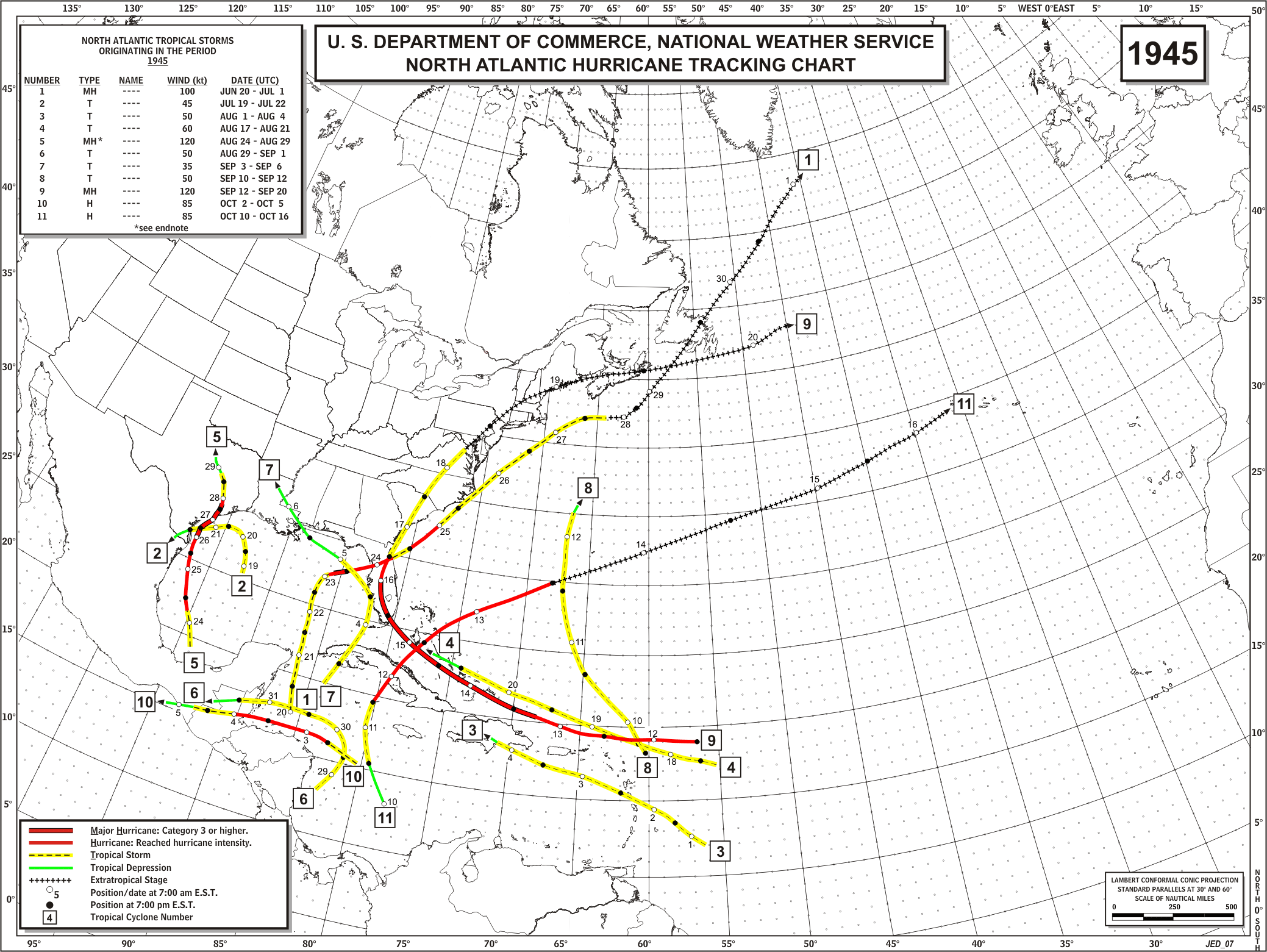
HURRICANE (Cat. 1* - July 27th landfall)
This hurricane moved inland over Bolivar Peninsula near Galveston Bay. Houston had a wind gust to 132 mph, Texas City recorded a gust of 104 mph, and Beaumont recorded 17.76" of rain. Nineteen persons died. Damage totaled $17 million. More information on this "surprise" hurricane can be found in this NOAA History story .
* - Hurrtrak data indicated a Category 1 status; NHC/TPC documents had peak at a Category 2.
HURRICANE (Cat. 1 - August 21st landfall)
This hurricane hit near Galveston with maximum winds at landfall at 72 mph, barometer at 29.35", and a storm tide of 7' at High Island.
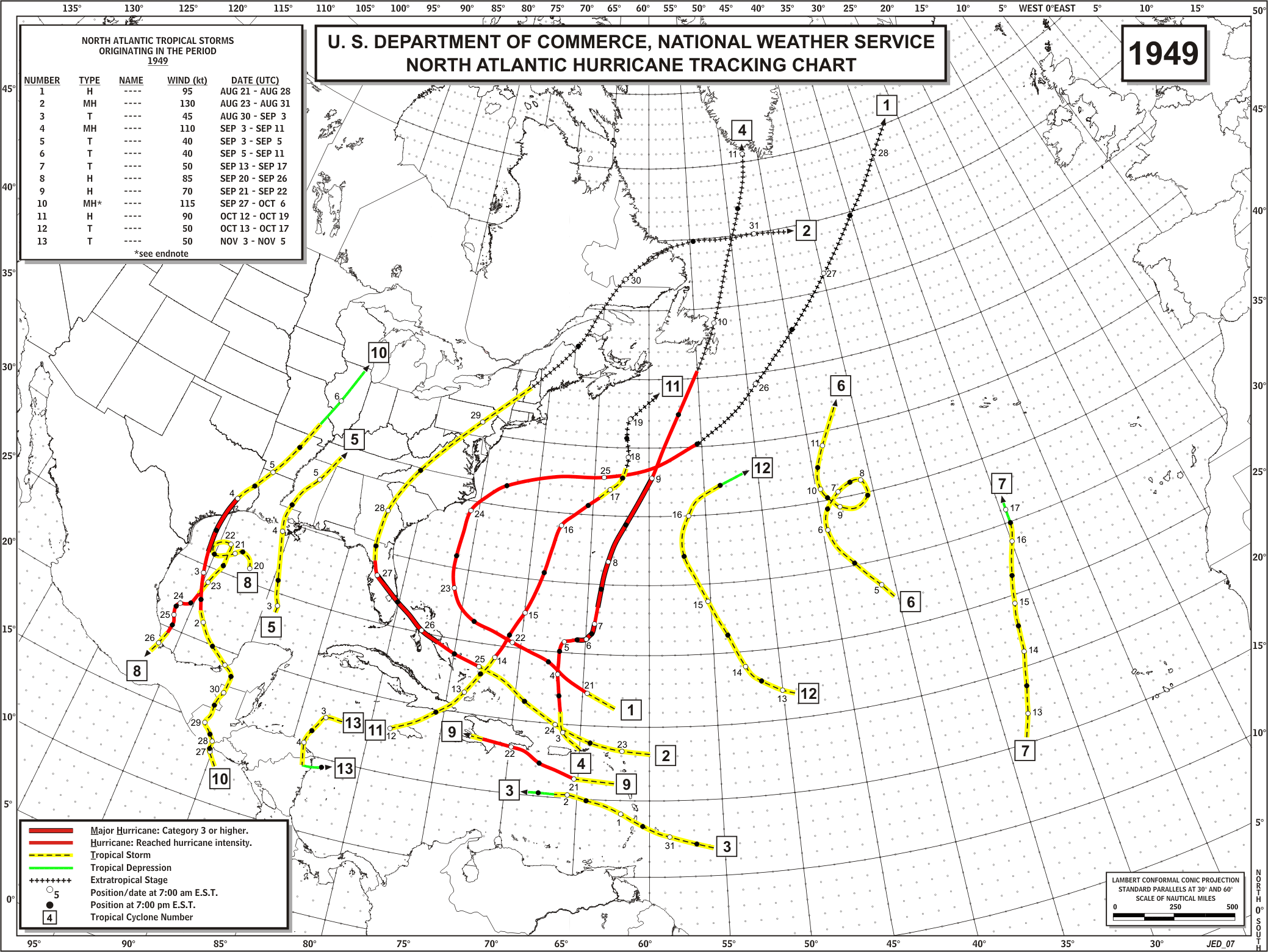
HURRICANE (Cat. 1* - August 30th landfall)
This hurricane formed near Grand Cayman Island on 8/26 and moved toward the Texas coast. On the morning of the 29th in Corpus Christi, 7,000 people on North Beach were evacuated. Heavy rains fell, and winds gusted during the day, blowing at 42 mph by 11:30 PM. At 2:30 AM on the 30th, the storm made landfall on Matagorda Bay with 110 mph winds, a 14.7' storm surge, and a central pressure of 28.10 inches. Storm winds and some property damage was occurred as far west as San Antonio. The hurricane killed eight persons.
* - This hurricane was a Category 3 well offshore, but weakened to a Category 1 by landfall.
Statistics:
Pressure (inches): 28.21 at Coast Guard in Port O'Connor; 28.80 inches at Palacios.
Tides (feet): 13.8 at Port O'Connor.
TROPICAL STORM (September 15th landfall)
This tropical storm made landfall west of Sabine Pass near Beaumont. Peak winds were 40 mph, and the lowest pressure was 1003 mb.
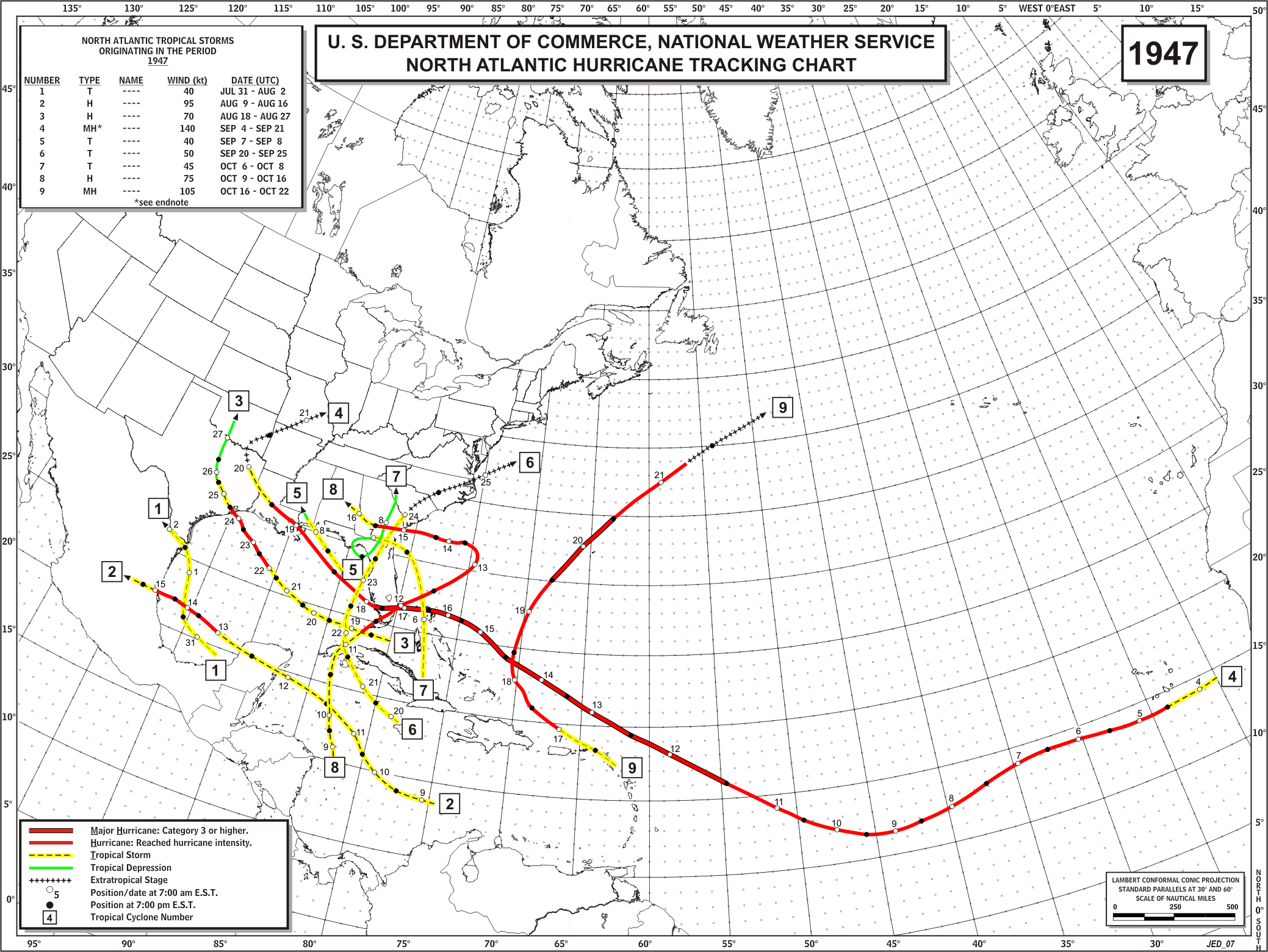
HURRICANE (Cat. 1* - September 23rd landfall)
This hurricane made landfall near Freeport with an estimated 110 mph winds, tides of 10.6', and a barometer of 28.31 inches. Extremely high tides were reported along the entire coast from Matagorda to Galveston. Four lives were lost, and property damage was estimated at $6.5 million. This hurricane reached Category 3 status at its peak while well offshore.
* - This hurricane was a Category 3 well offshore, but weakened to a Category 1 by landfall.
Statistics:
Winds (mph): 83 at Texas City; 75 at Houston.
Pressure (inches): 28.66 at Houston.
Tides (feet): 11 at Matagorda; 9.9 at Sargent.
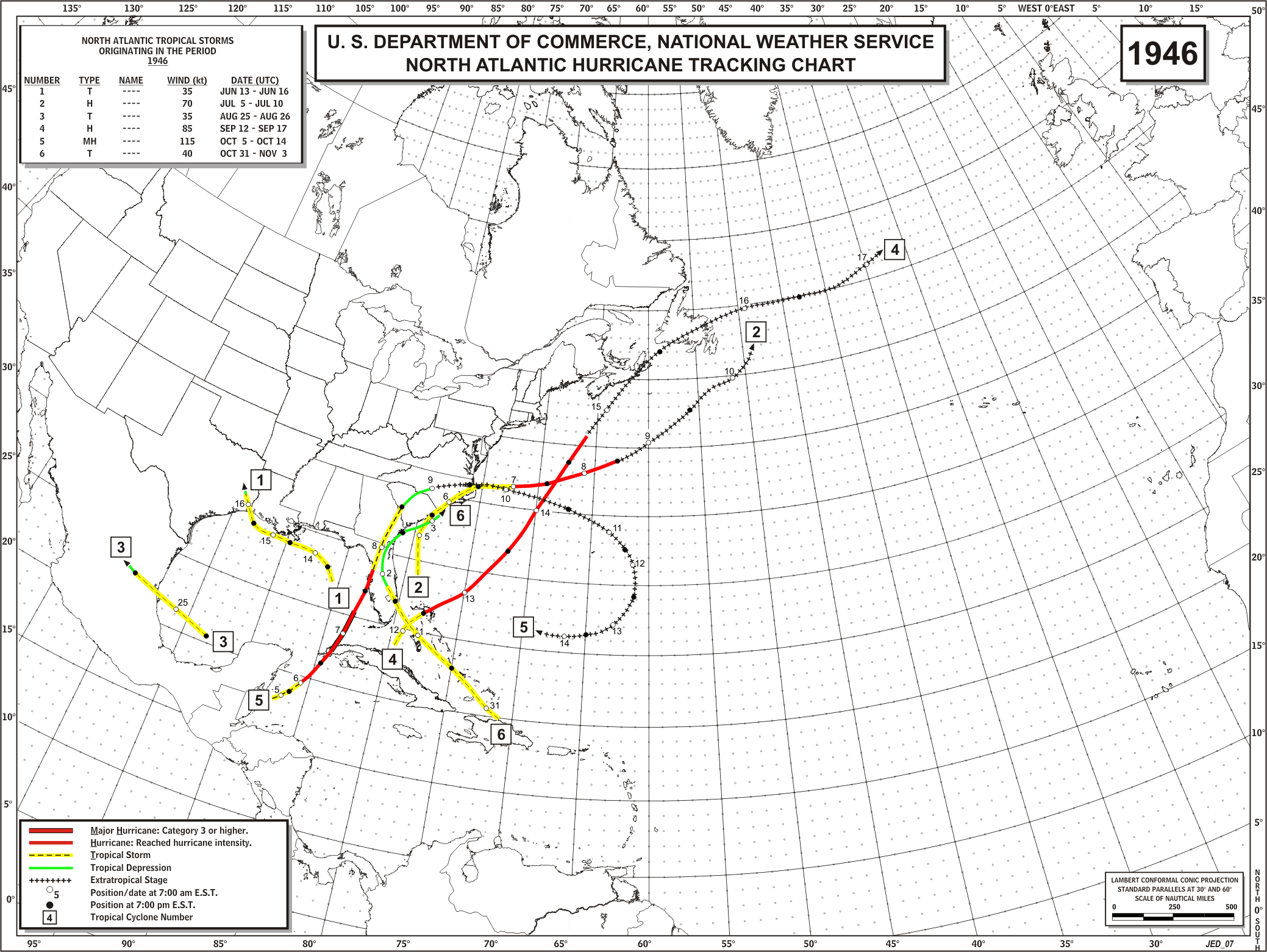
HURRICANE (Cat. 2 - August 7th landfall)
This system formed off the Georgia coast them moved southwest across FL and into the Gulf of America. Five days later, the strengthened system made landfall as a hurricane near Beaumont with 91 mph winds, a pressure of 28.87 inches, and a surge of 21.1'. Maximum winds recorded at Galveston were 46 mph. The hurricane caused at least 1 death and 9 injuries. Total damage was $1.75 million.
TROPICAL STORM (September 23rd landfall)
This tropical storm moved toward the Lower TX coast then curved sharply to the northeast. The storm moved parallel to the upper coast and just offshore until making landfall in Western LA. Rainfall was widespread but not excessive along the entire TX coast.

