
The Winter Outbreak that occurred on Valentine's Week 2021 brought not only snow, sleet, and freezing rain to Southeast Texas, but also extreme cold temperatures that lasted for several days. This was one of the most impactful winter events in recent history that brought multiday road closures, power outages, loss of heat, broken pipes, and other societal impacts for the region. While the damage is still being assessed, this will likely go down as the first billion dollar disaster of 2021 globally, and potentially the most costly weather disaster for the state of Texas in history, surpassing even Hurricane Harvey from 2017.
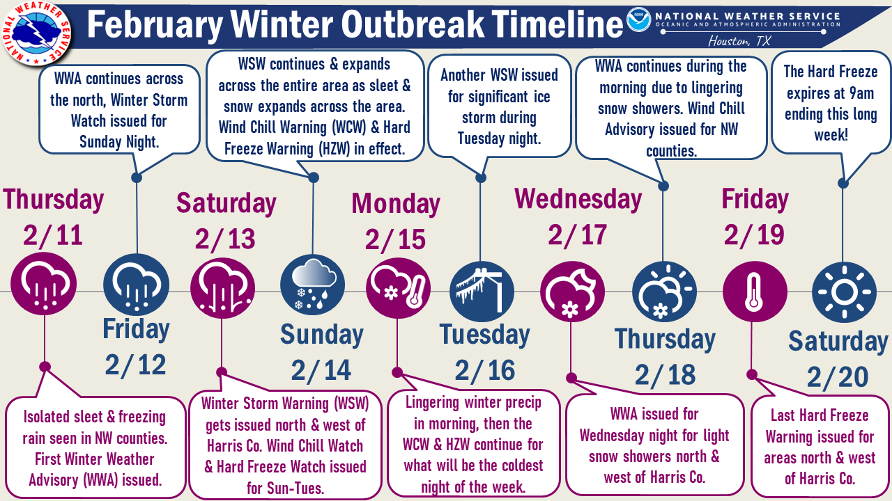
It all began Wednesday, February 10th when a cold front moved through the area bringing the first surge of cold air into the region. With this cold air in place, lingering precipitation the following day fell as sleet and freezing rain across the northwestern counties. The first Winter Weather Advisory of this prolonged winter event was issued in the morning hours of Thursday, February 11th for Burleson, Brazos, and Madison counties as area roads began to become hazardous from the icy precipitation. This Advisory would end up getting expanded to include Washington and Grimes counties after sunset that evening and continued through Friday morning due to lingering precipitation. While this first taste of winter precipitation was impacting the region, a stronger Arctic cold front was progressing through the country and was expected to reach Southeast Texas late Sunday. On Friday, February 12th, a Winter Storm Watch was issued for the entire region for Sunday in anticipation for the potential snow, sleet, and freezing rain that this Arctic front would bring. A Winter Storm Warning ended up getting issued on Saturday, February 13th for Colorado, Austin, Waller, Montgomery, San Jacinto, Polk counties and for counties north as sleet and freezing rain formed ahead of the approaching cold front. The counties that remained in the Winter Storm Watch (Jackson, Wharton, Fort Bend, Harris, and Liberty counties and the other counties along the coast) got upgraded to a Warning for Sunday.
As expected, the strong Arctic cold front passed through Southeast Texas on Sunday (Valentine's Day). It served as the turning point from a significant winter storm the preceded the front to the historic winter event that would eventually unfold.
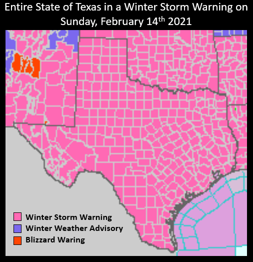
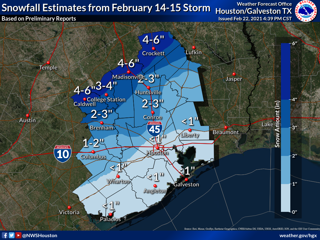
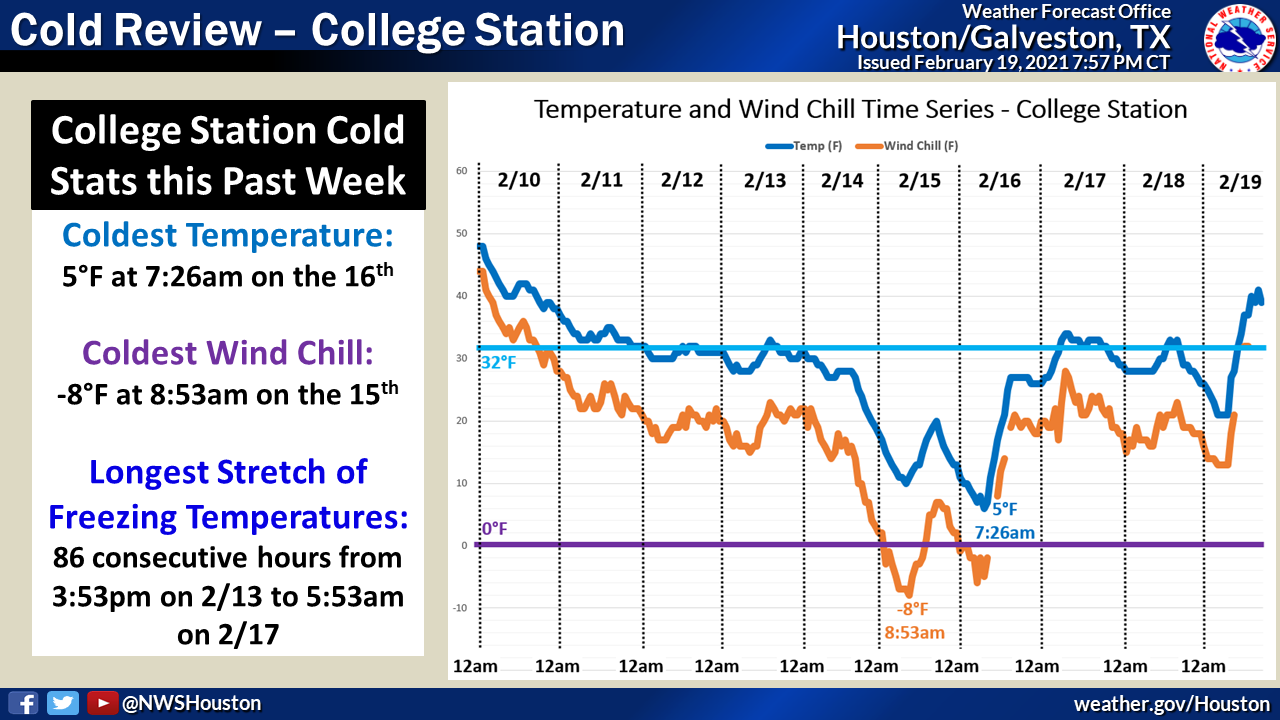
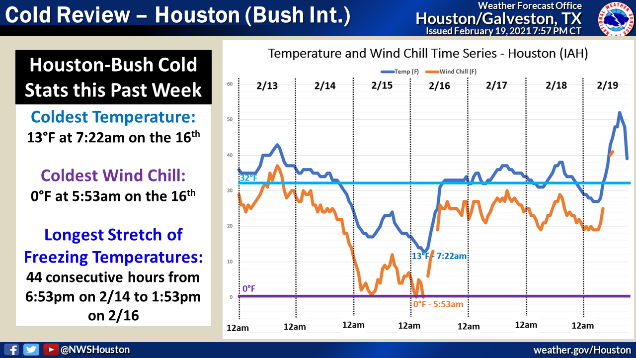
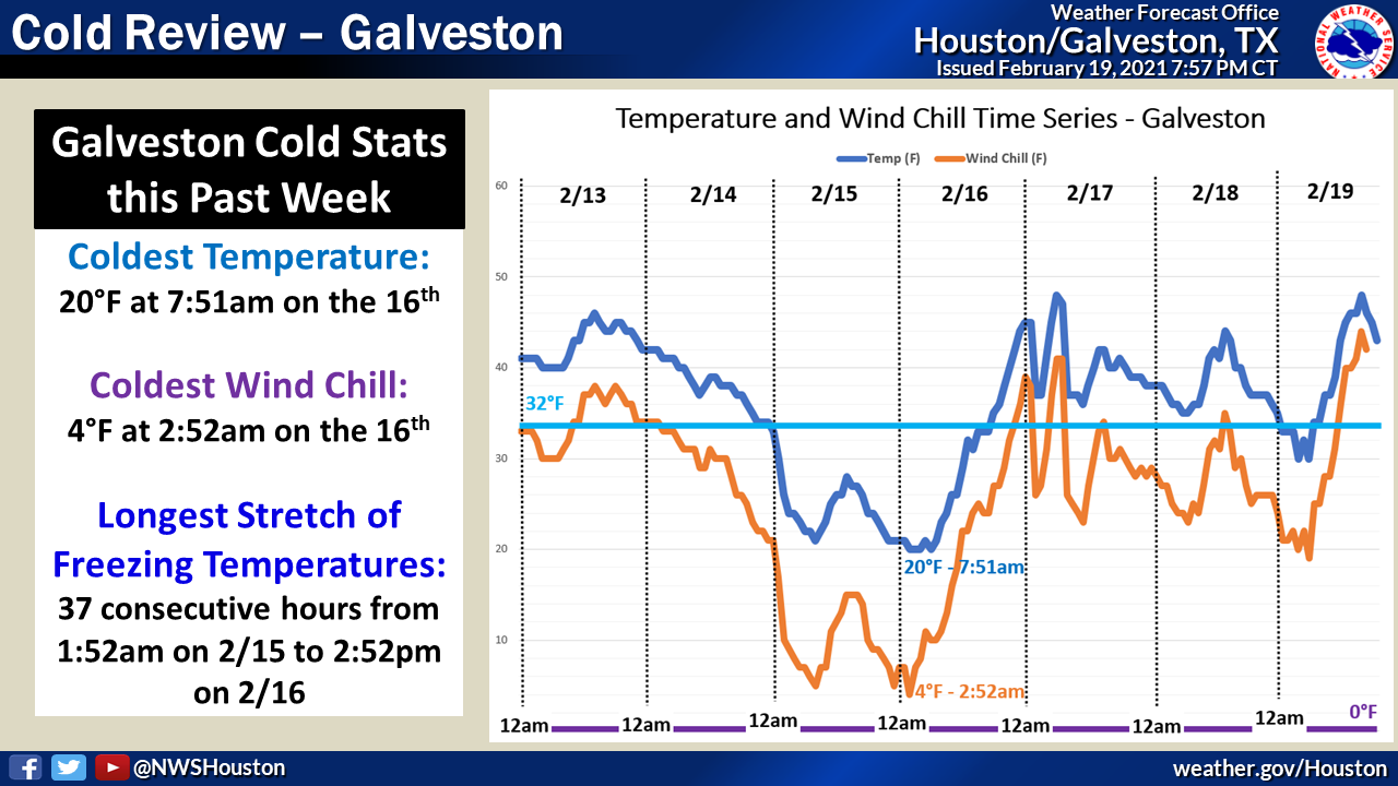
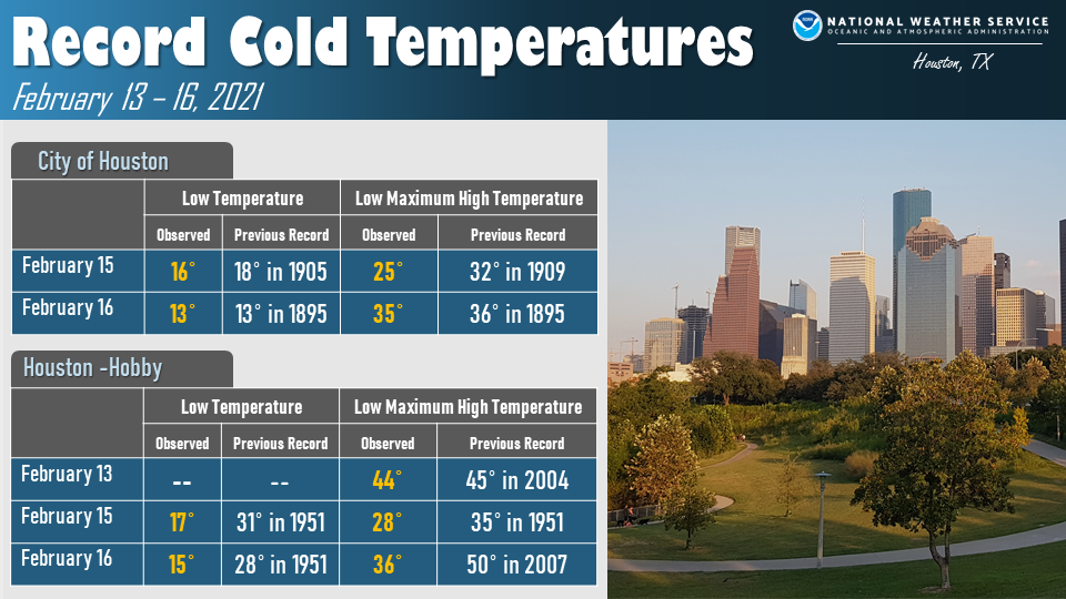
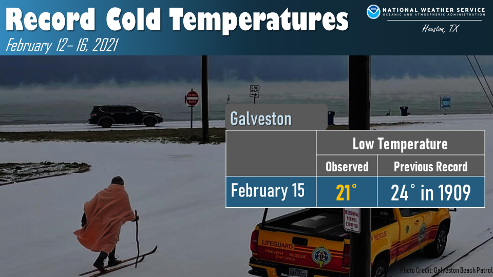
On Sunday, every square inch of Texas was in a Winter Storm Warning. Snow, sleet, and freezing rain began to encroach into Southeast Texas Sunday afternoon, and then increased in coverage and intensity overnight Sunday night into Monday. Thunder snow was reported near the town of Snook, Burleson County Sunday evening, and then thunder sleet occurred near the Brazoria and Galveston counties coastline Sunday night. Roads began to become impassable through the region Sunday evening due to ice and snow and some would not become safe until Friday. Temperatures crashed down Sunday night behind the cold front with much of the area getting down into the teens or single digits with wind chills down into the single digits or even below zero. Because of these conditions, a Hard Freeze Warning and a Wind Chill Warning (the first in our office's history) was in effect Sunday night/Monday morning. A combination of the icy conditions and extreme cold temperatures caused widespread power outages that would last for the next several days. The wintry precipitation continued through Monday morning with storm total snow/sleet accumulations being around trace along the coast, around an inch near the Houston Metro, and up to three to six inches up across the north. The extreme cold temperatures not just persisted through Tuesday morning, but dipped down even colder and produced the coldest morning of the event: the City of Houston went down to 13°F, Galveston down to 20°F, and College Station bottomed out at just 5°F.
Unfortunately, the week wasn't done yet. Another winter storm was anticipated to bring significant freezing rain along and north of Interstate-10 Tuesday night requiring an additional Winter Storm Warning. This new ice accumulation, combined with any refreezing of previous moisture, continued the hazardous road conditions Tuesday evening through the day on Wednesday. Conditions did not improve Wednesday night as lingering precipitation brought snow and sleet to the northern half of the region that lasted through midday Thursday. While the wintry precipitation wound down Thursday evening, the dangerously cold temperatures and hazardous road conditions continued. It wasn't until 9am Saturday morning that the last Hard Freeze Warning would expire for this event.
There was a total of 8 days, 23 hours, and 23 minutes of winter highlights between the first Winter Weather Advisory issued on Thursday, February 11th at 9:37am to when the last Hard Freeze Warning expired at 9am on Saturday, February 20th.
The winter outbreak in February 2021 will be on the minds of every Texan for a very long time.
.gif) |
 |
| Visible satellite imagery from February 15th, 2021 showing snow and ice cover over much of the state of Texas. |
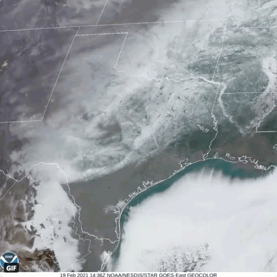
Visible satellite imagery from February 19th, 2021 showing snow and ice cover receding to the north. |
 |
 |
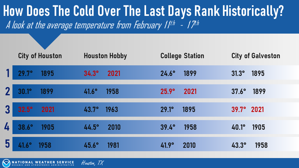
| A look at the average temperatures from February 11th-17th | The Great Plains Arctic Blast of 2021 |
Snow/Ice Reports

Here is a list of some of the Ice and Storm Reports
PUBLIC INFORMATION STATEMENT
NATIONAL WEATHER SERVICE HOUSTON/GALVESTON TX
1001 AM CST TUE FEB 16 2021

...UPDATED PRECIPITATION REPORTS FROM FEBRUARY 14-15 WINTER STORM...

...FREEZING RAIN REPORTS...

LOCATION                     AMOUNT    TIME/DATE       LAT/LON

...BURLESON COUNTY...
8 WNW SOMERVILLE             0.25 IN   0800 AM 02/15   30.40N/96.64W

...FORT BEND COUNTY...
2 SW KATY                    0.01 IN   0620 PM 02/14   29.78N/95.85W
3 NE BEASLEY                 0.01 IN   0636 PM 02/14   29.52N/95.87W

...GALVESTON COUNTY...
3 SE BAYOU VISTA             0.01 IN   0915 PM 02/14   29.30N/94.90W

...HARRIS COUNTY...
3 ESE KATY                   0.01 IN   0542 PM 02/14   29.79N/95.78W
1 ESE HOUSTON                0.01 IN   0727 PM 02/14   29.76N/95.37W

...MONTGOMERY COUNTY...
1 WNW MAGNOLIA               0.01 IN   0600 PM 02/14   30.21N/95.76W

...SLEET REPORTS...

LOCATION                     AMOUNT    TIME/DATE       LAT/LON

...BRAZORIA COUNTY...
2 NW LAKE JACKSON            0.2 IN    0530 AM 02/15   29.07N/95.47W

...FORT BEND COUNTY...
1 WNW TOWN WEST              2.0 IN    0512 AM 02/15   29.67N/95.65W
MEADOWS                      0.1 IN    1143 AM 02/15   29.65N/95.58W

...GALVESTON COUNTY...
1 N KEMAH                    0.7 IN    1030 AM 02/15   29.54N/95.02W
4 NE GALVESTON               0.5 IN    0915 AM 02/15   29.27N/94.84W
2 WNW LEAGUE CITY            0.3 IN    0745 AM 02/15   29.49N/95.13W
2 ENE DICKINSON              0.1 IN    0106 AM 02/15   29.46N/95.04W
1 N FRIENDSWOOD              0.1 IN    0955 AM 02/15   29.53N/95.20W

...HARRIS COUNTY...
5 WSW BUNKER HILL VILLAGE    4.0 IN    0232 AM 02/15   29.75N/95.61W
4 SW BUNKER HILL VILLAGE     3.0 IN    0832 AM 02/15   29.73N/95.58W
4 SSE HOUSTON                3.0 IN    1020 AM 02/15   29.72N/95.36W
4 SW THE WOODLANDS           2.0 IN    0320 AM 02/15   30.12N/95.54W
3 SW JERSEY VILLAGE          1.5 IN    0832 AM 02/15   29.86N/95.60W
2 SW BELLAIRE                1.2 IN    1020 AM 02/15   29.68N/95.49W
1 WNW KINGWOOD               1.0 IN    0346 AM 02/15   30.06N/95.19W
7 SE TOMBALL                 0.6 IN    0800 AM 02/15   30.02N/95.54W
1 NNE FRIENDSWOOD            0.5 IN    0725 AM 02/15   29.53N/95.19W
3 WSW BUNKER HILL VILLAGE    0.5 IN    0846 AM 02/15   29.75N/95.57W
NASSAU BAY                   0.5 IN    1032 AM 02/15   29.55N/95.09W
1 S NASSAU BAY               0.4 IN    0830 AM 02/15   29.54N/95.09W
2 NNW WEBSTER                0.3 IN    0800 AM 02/15   29.55N/95.13W
3 NNW WEBSTER                0.3 IN    1030 AM 02/15   29.57N/95.13W
LA PORTE                     0.3 IN    1036 AM 02/15   29.67N/95.05W
4 NE PEARLAND                0.3 IN    1127 AM 02/15   29.60N/95.23W
1 E EL LAGO                  0.1 IN    0830 AM 02/15   29.57N/95.03W
2 W HOUSTON                  0.1 IN    0900 AM 02/15   29.77N/95.42W

...MONTGOMERY COUNTY...
6 WNW THE WOODLANDS          1.4 IN    0900 AM 02/15   30.20N/95.57W
6 NNE TOMBALL                1.0 IN    0526 AM 02/15   30.18N/95.59W

...WALKER COUNTY...
2 NW HUNTSVILLE              0.3 IN    1000 PM 02/14   30.74N/95.57W

...WALLER COUNTY...
7 NNE WALLER                 0.3 IN    0922 PM 02/14   30.16N/95.89W

...WASHINGTON COUNTY...
1 N BRENHAM                  4.0 IN    0920 AM 02/15   30.17N/96.40W

...WHARTON COUNTY...
1 W EL CAMPO                 0.4 IN    0900 AM 02/15   29.19N/96.29W

...SNOWFALL REPORTS...

LOCATION                     AMOUNT    TIME/DATE       LAT/LON

...AUSTIN COUNTY...
SEALY                        4.2 IN    0700 AM 02/15   29.78N/96.16W
1 WNW SAN FELIPE             3.8 IN    0700 AM 02/15   29.80N/96.12W
8 SSW BELLVILLE              2.0 IN    0700 AM 02/15   29.85N/96.32W
1 ENE BELLVILLE              2.0 IN    0700 AM 02/15   29.95N/96.25W
BELLVILLE                    2.3 IN    0600 AM 02/15   29.95N/96.25W

...BRAZOS COUNTY...
1 E COLLEGE STATION          6.0 IN    0930 AM 02/15   30.62N/96.32W
1 WSW COLLEGE STATION        4.0 IN    1000 AM 02/15   30.62N/96.34W
1 WNW WELLBORN               3.5 IN    0700 AM 02/15   30.54N/96.33W
BRYAN                        3.5 IN    0652 AM 02/15   30.67N/96.37W
1 NNE UR089                  2.7 IN    0800 AM 02/15   30.72N/96.39W
2 S COLLEGE STATION          2.5 IN    0850 AM 02/15   30.59N/96.33W

...BURLESON COUNTY...
8 WNW SOMERVILLE             5.9 IN    0800 AM 02/15   30.40N/96.64W

...CHAMBERS COUNTY...
1 NE ANAHUAC                 0.1 IN    0738 AM 02/15   29.77N/94.66W

...COLORADO COUNTY...
3 WSW COLUMBUS               3.0 IN    0954 PM 02/15   29.69N/96.60W
5 E WEIMAR                   1.5 IN    0845 AM 02/15   29.70N/96.70W

...FORT BEND COUNTY...
6 WNW MISSION BEND           1.0 IN    0808 AM 02/15   29.72N/95.76W
1 N PECAN GROVE              0.5 IN    0600 AM 02/15   29.65N/95.73W
2 SW MISSION BEND            0.1 IN    0428 AM 02/15   29.67N/95.69W

...GALVESTON COUNTY...
2 ENE DICKINSON              2.0 IN    0750 AM 02/15   29.46N/95.04W
1 WNW BAYOU VISTA            1.5 IN    0800 AM 02/15   29.33N/94.95W
1 SSE JAMAICA BEACH          0.5 IN    0820 AM 02/15   29.18N/94.98W
2 NW DICKINSON               0.3 IN    0800 AM 02/15   29.47N/95.08W
3 NE GALVESTON               0.1 IN    0154 AM 02/15   29.26N/94.86W

...GRIMES COUNTY...
10 SSW IOLA                  4.5 IN    0800 AM 02/15   30.63N/96.14W

...HARRIS COUNTY...
CYPRESS                      3.0 IN    0754 AM 02/15   29.98N/95.68W
1 SE KINGWOOD                3.0 IN    0735 AM 02/15   30.05N/95.18W
TOMBALL                      3.0 IN    0658 AM 02/15   30.10N/95.61W
KATY                         2.0 IN    0800 AM 02/15   29.79N/95.82W
1 NW HEDWIG VILLAGE          1.2 IN    1130 AM 02/15   29.79N/95.53W
4 SE CYPRESS                 1.0 IN    0700 AM 02/15   29.94N/95.63W
BELLAIRE                     1.0 IN    0700 AM 02/15   29.70N/95.47W
WEST UNIVERSITY PLACE        0.8 IN    0645 AM 02/15   29.72N/95.44W
4 N MEADOWS                  0.8 IN    0714 AM 02/15   29.71N/95.58W
3 E WEST UNIVERSITY PLACE    0.7 IN    0730 AM 02/15   29.72N/95.38W
1 N NASSAU BAY               0.5 IN    0700 AM 02/15   29.56N/95.09W
4 NNW NASSAU BAY             0.3 IN    0700 AM 02/15   29.59N/95.11W
2 SE LA PORTE                0.3 IN    0654 AM 02/15   29.65N/95.02W
3 NNW NASSAU BAY             0.2 IN    0816 AM 02/15   29.58N/95.11W

...HOUSTON COUNTY...
5 NE LOVELADY                3.8 IN    0800 AM 02/15   31.18N/95.39W
2 NNE CROCKETT               3.6 IN    0930 AM 02/15   31.34N/95.44W

...MADISON COUNTY...
5 ENE MADISONVILLE           3.0 IN    0930 AM 02/15   30.97N/95.83W

...MONTGOMERY COUNTY...
6 ENE MONTGOMERY             5.0 IN    0700 AM 02/15   30.42N/95.61W
3 SW STAGECOACH              3.1 IN    0700 AM 02/15   30.11N/95.75W
1 E CONROE                   2.5 IN    0800 AM 02/15   30.32N/95.46W
4 W STAGECOACH               2.0 IN    0800 AM 02/15   30.14N/95.78W
1 S THE WOODLANDS            2.0 IN    0539 AM 02/14   30.14N/95.49W
5 NNW THE WOODLANDS          1.7 IN    0700 AM 02/15   30.22N/95.52W

...POLK COUNTY...
LIVINGSTON                   3.0 IN    0600 AM 02/15   30.71N/94.93W
1 WSW ONALASKA               2.5 IN    0700 AM 02/15   30.81N/95.12W
5 ENE GOODRICH               1.3 IN    0800 AM 02/15   30.65N/94.87W

...TRINITY COUNTY...
5 NW TRINITY                 5.1 IN    0700 AM 02/15   31.00N/95.43W
6 ESE GROVETON               3.0 IN    0600 AM 02/15   31.03N/95.04W

...WALKER COUNTY...
5 NNW HUNTSVILLE             4.0 IN    0600 AM 02/15   30.78N/95.58W
3 WSW HUNTSVILLE             3.6 IN    0700 AM 02/15   30.70N/95.59W
2 NW HUNTSVILLE              3.5 IN    0600 AM 02/15   30.73N/95.57W
7 ESE HUNTSVILLE             3.0 IN    0600 AM 02/15   30.67N/95.44W

...WASHINGTON COUNTY...
1 E BRENHAM                  2.5 IN    0700 AM 02/15   30.16N/96.39W
3 NNW BRENHAM                2.0 IN    0700 AM 02/15   30.20N/96.41W
1 NNE BRENHAM                1.5 IN    0830 AM 02/15   30.18N/96.39W

OBSERVATIONS ARE COLLECTED FROM A VARIETY OF SOURCES WITH VARYING
EQUIPMENT AND EXPOSURES. WE THANK ALL VOLUNTEER WEATHER OBSERVERS
FOR THEIR DEDICATION. NOT ALL DATA LISTED ARE CONSIDERED OFFICIAL.
Frigid Temperatures


PUBLIC INFORMATION STATEMENT NATIONAL WEATHER SERVICE HOUSTON/GALVESTON TX 200 PM CST WED FEB 17 2021 ...LOW TEMPERATURE REPORTS FOR FEBRUARY 15-17 WINTER STORM EVENT... THE FOLLOWING OBSERVATIONS NOTE THE LOWEST RECORDED TEMPERATURES ACROSS SOUTHEAST TEXAS OVER THE PAST 72 HOURS. PLEASE NOTE THAT NOT ALL DATA ARE CONSIDERED OFFICIAL AND REPORTS ARE OBTAINED FROM A VARIETY OF SOURCES. LOCATION TEMP TIME/DATE LAT/LON ...AUSTIN COUNTY... CAT SPRING 6 F 0732 AM 02/16 29.89N/96.38W INDUSTRY 3 W 7 F 0710 AM 02/16 29.98N/96.55W 8.8 NE FAYETTEVILLE 8 F 0700 AM 02/16 29.98N/96.55W BELLVILLE 1 SW 9 F 0725 AM 02/16 29.94N/96.27W 8.3 S BELLVILLE (UPR) 10 F 0715 AM 02/16 29.83N/96.28W BELLVILLE 1 SW 10 F 0700 AM 02/16 29.94N/96.27W SAN FELIPE 11 F 0647 AM 02/16 29.80N/96.12W ...BRAZORIA COUNTY... KATY 12 F 0733 AM 02/16 29.42N/95.45W 2.8 E SWEENY (UPR) 12 F 0715 AM 02/16 29.04N/95.65W 2.7 S BAILEY'S PRAIRIE (UPR) 12 F 0645 AM 02/16 29.11N/95.49W RICHWOOD 13 F 0715 AM 02/16 29.07N/95.42W ALVIN 13 F 0705 AM 02/16 29.40N/95.28W WEST COLUMBIA 13 F 1020 AM 02/15 29.14N/95.65W PEARLAND 14 F 0750 AM 02/16 29.56N/95.29W LAKE JACKSON 14 F 0730 AM 02/16 29.04N/95.45W DAMON 1 NNW 14 F 0730 AM 02/16 29.30N/95.74W WEST COLUMBIA 15 F 0751 AM 02/16 29.13N/95.65W 1 E LAKE JACKSON 15 F 0715 AM 02/16 29.04N/95.43W ANGLETON LAKE JACKSON: BRAZ 15 F 0653 AM 02/16 29.12N/95.46W SAN BERNARD NWR 15 F 0629 AM 02/16 28.86N/95.57W HOUSTON: PEARLAND REGIONAL A 16 F 0735 AM 02/16 29.52N/95.24W 1 E FREEPORT 16 F 0650 AM 02/16 28.95N/95.34W BRAZORIA NWR 16 F 0628 AM 02/16 29.15N/95.30W 2.7 NE DANBURY (UPR) 16 F 1040 AM 02/15 29.26N/95.32W MANVEL 16 F 0726 AM 02/15 29.52N/95.38W FREEPORT 17 F 0739 AM 02/16 28.94N/95.35W 2.3 S HILLCREST (UPR) 17 F 0640 AM 02/16 29.36N/95.22W IOWA COLONY 17 F 0610 AM 02/15 29.44N/95.45W 0.6 S JONES CREEK (WEATHERST 18 F 1000 AM 02/16 28.97N/95.46W ALVIN 20 F 0437 AM 02/15 29.48N/95.24W LAKE JACKSON 22 F 0811 AM 02/16 29.05N/95.43W PEARLAND 22 F 0247 AM 02/15 29.55N/95.42W ALVIN 22 F 0213 AM 02/15 29.42N/95.24W ...BRAZOS COUNTY... COLLEGE STATION 2 F 0712 AM 02/16 30.56N/96.23W 4.8 W UP403 (UPR) 3 F 0535 AM 02/16 30.69N/96.56W 3 E WELLBORN 4 F 0740 AM 02/16 30.53N/96.24W 2 SSE COLLEGE STATION 4 F 0715 AM 02/16 30.55N/96.36W COULTER FLD AP 4 F 0655 AM 02/16 30.72N/96.33W EASTERWOOD FIELD AIRPORT 5 F 1153 PM 02/16 30.58N/96.37W COLLEGE STATION: EASTERWOOD 5 F 0725 AM 02/16 30.58N/96.36W 3 E UP429 5 F 0633 AM 02/16 30.55N/96.25W UP429 (UPR) 6 F 0720 AM 02/16 30.55N/96.30W 2 N UP429 6 F 0705 AM 02/16 30.58N/96.30W BRYAN 7 F 0411 AM 02/16 30.63N/96.35W UP403 (UPR) 7 F 0400 AM 02/16 30.67N/96.48W BRYAN 8 F 0823 AM 02/15 30.57N/96.37W ...BURLESON COUNTY... 3.4 NE CALDWELL (UPR) 2 F 0700 AM 02/16 30.55N/96.65W CALDWELL 4 F 0715 AM 02/16 30.52N/96.70W FRENSTAT 5 F 0735 AM 02/16 30.40N/96.64W SOMERVILLE 5 F 0730 AM 02/16 30.40N/96.55W COLLEGE STATION 6 F 0715 AM 02/16 30.55N/96.43W 6.1 NE DIME BOX (UPR) 6 F 0715 AM 02/16 30.43N/96.76W 1.9 NE CALDWELL (WEATHERSTEM 6 F 0710 AM 02/16 30.55N/96.68W SNOOK 8 F 0816 AM 02/15 30.47N/96.48W ...CHAMBERS COUNTY... ANAHUAC 13 F 0712 AM 02/16 29.67N/94.44W MONT BELVIEU 13 F 0605 AM 02/16 29.86N/94.87W ...COLORADO COUNTY... 4.5 E FAYETTEVILLE (UPR) 3 F 0635 AM 02/16 29.92N/96.60W FAYETTEVILLE 6 F 0725 AM 02/16 29.91N/96.58W CUMMINS CREEK NEAR FRELSBURG 7 F 0725 AM 02/16 29.83N/96.58W 7.3 SW COLUMBUS (TWDB) 7 F 0720 AM 02/16 29.66N/96.66W 7.9 SE FAYETTEVILLE 7 F 0700 AM 02/16 29.83N/96.58W COLUMBUS 7 F 0650 AM 02/16 29.71N/96.56W 4.9 E WEIMAR (UPR) 8 F 0725 AM 02/16 29.70N/96.70W 10.4 E COLUMBUS (TWDB) 8 F 0705 AM 02/16 29.76N/96.39W 7 W EAGLE LAKE 8 F 0655 AM 02/16 29.57N/96.45W WEIMAR 7 S 8 F 0610 AM 02/16 29.60N/96.77W 6.8 S WEIMAR 9 F 0700 AM 02/16 29.60N/96.77W ATTWATER NWR 9 F 0635 AM 02/16 29.67N/96.27W COLORADO RIVER AT COLUMBUS 10 F 0725 AM 02/16 29.71N/96.54W COLUMBUS 10 F 0715 AM 02/16 29.65N/96.52W WEIMAR 10 F 0818 AM 02/15 29.71N/96.71W 6.9 SW EAGLE LAKE 12 F 0700 AM 02/16 29.52N/96.41W EAGLE LAKE 12 F 0635 AM 02/16 29.60N/96.32W 7.1 NW EAGLE LAKE (UPR) 12 F 0625 AM 02/16 29.66N/96.41W ...FORT BEND COUNTY... 3.7 W ROSENBERG (UPR) 3 F 0645 AM 02/16 29.56N/95.86W 3.6 N BEASLEY (UPR) 10 F 0815 AM 02/16 29.55N/95.91W 3 NW RICHMOND 10 F 0725 AM 02/16 29.62N/95.81W KATY 10 F 0717 AM 02/16 29.76N/95.78W KATY 11 F 0748 AM 02/16 29.76N/95.80W KATY 12 F 0745 AM 02/16 29.71N/95.75W 3 ENE FULSHEAR 12 F 0855 AM 02/15 29.72N/95.84W 4 S KATY 12 F 0755 AM 02/15 29.73N/95.83W ROSENBERG 13 F 0722 AM 02/16 29.52N/95.81W MISSOURI CITY 13 F 0631 AM 02/16 29.60N/95.57W FIRST COLONY 13 F 1100 AM 02/15 29.58N/95.60W RICHMOND 13 F 0748 AM 02/15 29.58N/95.76W FULSHEAR 13 F 0746 AM 02/15 29.66N/95.91W MISSOURI CITY 14 F 0810 AM 02/16 29.56N/95.52W HOUSTON: SUGAR LAND MUNICIPA 14 F 0720 AM 02/16 29.62N/95.66W STAFFORD 14 F 0719 AM 02/16 29.61N/95.56W HOUSTON SUGAR LA 14 F 0653 AM 02/16 29.62N/95.65W RICHMOND 14 F 0816 AM 02/15 29.69N/95.74W KATY 14 F 0804 AM 02/15 29.75N/95.79W RICHMOND 14 F 0803 AM 02/15 29.56N/95.74W SUGAR LAND 14 F 0744 AM 02/15 29.65N/95.63W SUGAR LAND 14 F 0729 AM 02/15 29.54N/95.67W 4 WSW FIRST COLONY 15 F 0900 AM 02/15 29.55N/95.68W KATY 15 F 0745 AM 02/15 29.73N/95.79W 3 SW THOMPSONS 15 F 0740 AM 02/15 29.45N/95.66W 4 E FULSHEAR 15 F 0610 AM 02/15 29.69N/95.82W HOUSTON SOUTHWST 18 F 0535 AM 02/15 29.52N/95.48W ...GALVESTON COUNTY... 1.6 SE WEBSTER (UPR) 13 F 0805 AM 02/16 29.52N/95.10W 13 S STOWELL 14 F 0700 AM 02/16 29.59N/94.39W FRIENDSWOOD 15 F 0810 AM 02/16 29.51N/95.21W LEAGUE CITY 15 F 0759 AM 02/16 29.49N/95.13W 1 NE LEAGUE CITY 15 F 0755 AM 02/16 29.50N/95.10W 1 SSE TEXAS CITY 15 F 0740 AM 02/16 29.39N/94.95W CRAB LAKE 16 F 0729 AM 02/16 29.47N/94.62W 2 W LEAGUE CITY 16 F 0325 AM 02/16 29.49N/95.15W LEAGUE CITY 16 F 0300 AM 02/16 29.50N/95.10W LEVEE 17 F 0811 AM 02/16 29.42N/94.89W TEXAS CITY 17 F 0732 AM 02/16 29.37N/94.95W SAN LEON 17 F 0717 AM 02/16 29.50N/94.95W 2 N BAYOU VISTA 18 F 0520 AM 02/16 29.36N/94.93W GALVESTON: SCHOLES FIELD 19 F 0730 AM 02/16 29.27N/94.86W GALVESTON 19 F 0447 AM 02/16 29.27N/94.87W ...GRIMES COUNTY... NAVASOTA 5 F 0705 AM 02/16 30.30N/96.00W NAVASOTA 6 F 0720 AM 02/16 30.39N/96.09W 3.9 NW TODD MISSION (UPR) 10 F 0645 AM 02/16 30.31N/95.86W ...HARRIS COUNTY... 4.3 E STAFFORD (UPR) 3 F 0745 AM 02/15 29.64N/95.49W 2 WNW SPRING 9 F 0710 AM 02/16 30.07N/95.42W 4.9 N ALDINE (UPR) 9 F 0610 AM 02/16 29.98N/95.39W 6 WSW SPRING 10 F 0725 AM 02/16 30.03N/95.48W 3 SW SPRING 10 F 0629 AM 02/16 30.06N/95.46W SPRING 11 F 0749 AM 02/16 30.05N/95.49W SPRING 11 F 0745 AM 02/16 30.07N/95.53W CYPRESS 11 F 0739 AM 02/16 29.95N/95.71W BEE CAVE 11 F 0739 AM 02/16 30.06N/95.54W KATY 11 F 0732 AM 02/16 29.76N/95.77W SPRING 11 F 0732 AM 02/16 30.04N/95.49W CYPRESS 11 F 0730 AM 02/16 29.95N/95.72W TOMBALL 11 F 0727 AM 02/16 30.02N/95.61W CYPRESS 11 F 0718 AM 02/16 29.95N/95.73W 2 NE HOUSTON 11 F 0715 AM 02/16 29.79N/95.36W 3 NE JERSEY VILLAGE 11 F 0705 AM 02/16 29.93N/95.53W HOUSTON 11 F 0656 AM 02/16 29.90N/95.68W 4 NNW HOUSTON 11 F 0605 AM 02/16 29.82N/95.41W 3 NE SOUTH HOUSTON 12 F 0755 AM 02/16 29.70N/95.20W WEBSTER 12 F 0755 AM 02/16 29.53N/95.12W HOUSTON 12 F 0727 AM 02/16 29.99N/95.59W HOUSTON INTERCONTINENTAL AIR 12 F 0720 AM 02/16 29.98N/95.36W HOUSTON 12 F 0711 AM 02/16 29.82N/95.54W HOUSTON 12 F 0710 AM 02/16 29.91N/95.66W 2 NNE SOUTH HOUSTON 12 F 0709 AM 02/16 29.70N/95.21W 5 N FRESNO 12 F 0705 AM 02/16 29.62N/95.45W 1.5 N DEER PARK (UPR) 12 F 0645 AM 02/16 29.71N/95.12W 1 NNW HOUSTON 12 F 0550 AM 02/16 29.79N/95.40W 3 SSE ALDINE 12 F 0431 AM 02/16 29.87N/95.36W 3 S BUNKER HILL VILLAGE 12 F 0303 AM 02/16 29.71N/95.54W 1 SSE PINEY POINT VILLAGE 12 F 0934 AM 02/15 29.74N/95.51W HOCKLEY 12 F 0903 AM 02/15 30.00N/95.78W HOUSTON INTNL 13 F 1153 PM 02/16 30.00N/95.37W 2 NE SOUTH HOUSTON 13 F 0800 AM 02/16 29.69N/95.19W KATY 13 F 0748 AM 02/16 29.84N/95.68W KATY 13 F 0748 AM 02/16 29.76N/95.73W 1 SE SOUTHSIDE PLACE 13 F 0745 AM 02/16 29.70N/95.42W 3 E HOUSTON 13 F 0734 AM 02/16 29.78N/95.32W HOUSTON 13 F 0721 AM 02/16 29.75N/95.52W SPRING 13 F 0718 AM 02/16 30.05N/95.44W 5 NE HILSHIRE VILLAGE 13 F 0715 AM 02/16 29.84N/95.42W 2 E HILSHIRE VILLAGE 13 F 0715 AM 02/16 29.78N/95.44W KINGWOOD 13 F 0620 AM 02/16 30.07N/95.20W 4.3 SW HUMBLE (UPR) 13 F 0505 AM 02/16 29.94N/95.29W 4 S ALDINE 13 F 0417 AM 02/16 29.86N/95.37W 1 SSE SOUTHSIDE PLACE 13 F 0940 AM 02/15 29.69N/95.43W 1 ENE CYPRESS 13 F 0900 AM 02/15 29.98N/95.65W 4 SSW ATASCOCITA 13 F 0840 AM 02/15 29.93N/95.20W 4 ESE HOUSTON 13 F 0820 AM 02/15 29.74N/95.33W HOUSTON DW HOOKS 14 F 1153 PM 02/16 30.07N/95.55W 2 WSW GALENA PARK 14 F 0800 AM 02/16 29.73N/95.27W 2 W SHOREACRES 14 F 0744 AM 02/16 29.62N/95.04W HOUSTON 14 F 0739 AM 02/16 29.80N/95.41W 1 WSW HOUSTON 14 F 0735 AM 02/16 29.76N/95.41W 1 E HOUSTON 14 F 0730 AM 02/16 29.77N/95.36W 2 ESE HOUSTON 14 F 0725 AM 02/16 29.75N/95.36W WEBSTER 14 F 0716 AM 02/16 29.54N/95.10W 2 E WEST UNIVERSITY PLACE 14 F 0715 AM 02/16 29.72N/95.40W 1 SSE PASADENA 14 F 0715 AM 02/16 29.67N/95.20W 1 NNW HILSHIRE VILLAGE 14 F 0714 AM 02/16 29.81N/95.49W HOUSTON 14 F 0712 AM 02/16 29.58N/95.12W 4 N BAYTOWN 14 F 0659 AM 02/16 29.82N/94.96W 4 SSW PASADENA 14 F 0650 AM 02/16 29.60N/95.17W 3.3 W JACINTO CITY (UPR) 14 F 0635 AM 02/16 29.75N/95.29W WEBSTER 14 F 0610 AM 02/16 29.53N/95.12W HOUSTON 14 F 0330 AM 02/16 29.80N/95.50W CROSBY 14 F 1025 AM 02/15 29.91N/95.06W HOUSTON: HOOKS MEMORIAL AIRP 14 F 0900 AM 02/15 30.07N/95.56W 4 NNE FRESNO 14 F 0805 AM 02/15 29.60N/95.42W 1.7 W JERSEY VILLAGE (UPR) 14 F 0730 AM 02/15 29.90N/95.59W HOUSTON 15 F 0219 AM 02/17 29.64N/95.13W HOUSTON HOBBY 15 F 1153 PM 02/16 29.63N/95.28W SPRING 15 F 0920 AM 02/16 30.07N/95.41W NASSAU BAY 15 F 0750 AM 02/16 29.55N/95.10W BAYTOWN 15 F 0750 AM 02/16 29.76N/94.96W HOUSTON 15 F 0749 AM 02/16 29.77N/95.51W 1 N BELLAIRE 15 F 0745 AM 02/16 29.72N/95.46W MORGANS POINT, TX 15 F 0742 AM 02/16 29.68N/94.98W 3 W JACINTO CITY 15 F 0734 AM 02/16 29.77N/95.30W HOUSTON 15 F 0733 AM 02/16 29.58N/95.23W DEER PARK 15 F 0431 AM 02/16 29.69N/95.14W SOUTHSIDE PLACE 15 F 0402 AM 02/16 29.70N/95.44W 2 S BELLAIRE 15 F 1044 AM 02/15 29.67N/95.45W 2 WSW KINGWOOD 15 F 0930 AM 02/15 30.04N/95.22W 1 SE HUNTERS CREEK VILLAGE 15 F 0430 AM 02/15 29.75N/95.48W EL LAGO 16 F 0748 AM 02/16 29.56N/95.05W 1 SE LA PORTE 16 F 0635 AM 02/16 29.65N/95.03W 2 WSW GALENA PARK 16 F 0224 AM 02/16 29.73N/95.27W HOUSTON 16 F 1030 AM 02/15 29.69N/95.52W HUMBLE 16 F 0852 AM 02/15 30.00N/95.17W FRIENDSWOOD 16 F 0847 AM 02/15 29.55N/95.18W HOUSTON 16 F 0745 AM 02/15 29.79N/95.39W 1 SSE HUNTERS CREEK VILLAGE 16 F 0715 AM 02/15 29.76N/95.49W MAGNOLIA 16 F 0429 AM 02/15 30.08N/95.75W 2 NNE HOUSTON 17 F 0207 AM 02/16 29.80N/95.37W HOUSTON 17 F 1135 PM 02/15 29.74N/95.39W CROSBY 17 F 1000 AM 02/15 29.95N/95.11W CYPRESS 17 F 0212 AM 02/15 29.95N/95.74W CYPRESS 17 F 0210 AM 02/15 29.94N/95.74W 3.8 NW CLOVERLEAF (UPR) 18 F 0635 AM 02/16 29.83N/95.21W 2 SE HUNTERS CREEK VILLAGE 18 F 0224 AM 02/15 29.75N/95.47W TOMBALL 18 F 0220 AM 02/15 30.10N/95.61W 4 ENE KATY 18 F 0219 AM 02/15 29.82N/95.75W HILSHIRE VILLAGE 18 F 0208 AM 02/15 29.78N/95.48W CYPRESS 19 F 0207 AM 02/15 29.95N/95.73W CLEAR LAKE PARK 20 F 1012 AM 02/16 29.56N/95.07W 10.6 S STAGECOACH (UPR) 20 F 0810 AM 02/15 29.99N/95.76W HOUSTON 21 F 1031 AM 02/16 29.75N/95.45W HUMBLE 22 F 1021 AM 02/16 29.93N/95.19W 5.5 SE HUMBLE (UPR) 22 F 0230 AM 02/15 29.94N/95.20W ...HOUSTON COUNTY... 9 W CROCKETT 2 F 0720 AM 02/16 31.31N/95.61W RATCLIFF 2 F 0602 AM 02/16 31.39N/95.14W 1.4 S LATEXO (UPR) 3 F 0725 AM 02/16 31.37N/95.48W CROCKETT 6 F 0816 AM 02/16 31.31N/95.61W 2.1 NW LOVELADY (UPR) 6 F 0425 AM 02/16 31.15N/95.46W 5 WSW CROCKETT 7 F 1250 AM 02/16 31.27N/95.53W ...JACKSON COUNTY... EDNA 12 F 0845 AM 02/15 28.97N/96.65W 9.3 SE INEZ (UPR) 13 F 0915 AM 02/15 28.79N/96.67W 2.9 W LA WARD (UPR) 14 F 0640 AM 02/16 28.84N/96.51W EDNA 14 F 0859 AM 02/15 28.98N/96.65W EDNA 15 F 0759 AM 02/16 28.94N/96.52W LA WARD 15 F 0849 AM 02/15 28.84N/96.46W LOLITA 15 F 0846 AM 02/15 28.79N/96.55W LA WARD 16 F 0716 AM 02/16 28.77N/96.45W FRANCITAS 16 F 0901 AM 02/15 28.86N/96.34W VANDERBILT 20 F 1218 PM 02/15 28.82N/96.62W ...LIBERTY COUNTY... KENEFICK (UPR) 10 F 0740 AM 02/16 30.11N/94.86W 7.5 W DAYTON (UPR) 10 F 0525 AM 02/16 30.05N/95.02W 4 ENE CLEVELAND 11 F 0715 AM 02/16 30.35N/95.00W SPLENDORA 11 F 0710 AM 02/16 30.27N/95.13W 5.8 SW DAYTON (UPR) 11 F 0700 AM 02/16 29.99N/94.96W DAYTON 12 F 0622 AM 02/16 30.11N/94.93W 5.2 S DAISETTA (UPR) 14 F 0700 AM 02/16 30.04N/94.66W 4.4 E DEVERS (UPR) 14 F 0645 AM 02/16 30.02N/94.51W 0.8 E HARDIN (UPR) 18 F 0750 AM 02/16 30.15N/94.72W ...MADISON COUNTY... MADISONVILLE 2 F 0732 AM 02/16 30.97N/95.83W MADISONVILLE 2 F 0635 AM 02/16 30.95N/95.92W 7 S NORMANGEE 10 F 1230 PM 02/15 30.92N/96.11W ...MATAGORDA COUNTY... 10.7 N PALACIOS (UPR) 14 F 0130 PM 02/15 28.87N/96.27W MIDFIELD 15 F 0725 AM 02/16 28.94N/96.21W SARGENT 1 ENE 15 F 0725 AM 02/16 28.84N/95.66W 14.6 S SWEENY 15 F 0700 AM 02/16 28.84N/95.66W COLORADO RIVER AT BAY CITY 16 F 0725 AM 02/16 28.97N/96.01W 2.9 W BAY CITY 16 F 0700 AM 02/16 28.97N/96.01W BAY CITY 16 F 1015 AM 02/15 28.97N/95.87W MARKHAM 16 F 0821 AM 02/15 28.97N/96.06W 4.8 SW BAY CITY (UPR) 18 F 0800 AM 02/16 28.92N/96.00W SARGENT 19 F 1231 PM 02/15 28.81N/95.67W ...MONTGOMERY COUNTY... MONTGOMERY 8 F 0735 AM 02/16 30.30N/95.63W CONROE 9 F 1153 PM 02/16 30.35N/95.42W CYPRESS 9 F 0748 AM 02/16 30.11N/95.70W CONROE: MONTGOMERY COUNTY AI 9 F 0735 AM 02/16 30.36N/95.41W 7 ENE CUT AND SHOOT 9 F 0725 AM 02/16 30.37N/95.24W WILLIS 9 F 0722 AM 02/16 30.39N/95.56W THE WOODLANDS 10 F 0748 AM 02/16 30.18N/95.54W WILLIS 10 F 0730 AM 02/16 30.42N/95.55W CONROE 10 F 0703 AM 02/16 30.24N/95.48W 2.5 SE OAK RIDGE NORTH (UPR) 10 F 0655 AM 02/16 30.13N/95.43W WILLIS (UPR) 10 F 0445 AM 02/16 30.43N/95.48W CONROE 11 F 0744 AM 02/16 30.15N/95.41W 3.1 N TOMBALL (UPR) 11 F 0515 AM 02/15 30.14N/95.63W 4 NE TODD MISSION 11 F 0509 AM 02/15 30.31N/95.77W HOUSTON 12 F 0358 AM 02/16 30.17N/95.44W MONTGOMERY 15 F 0500 AM 02/15 30.40N/95.64W CONROE 16 F 1000 AM 02/16 30.32N/95.49W PORTER 16 F 0532 AM 02/15 30.07N/95.25W 0.6 W WOODBRANCH (UPR) 18 F 1050 AM 02/16 30.19N/95.19W SPRING 18 F 0815 PM 02/15 30.09N/95.36W ...POLK COUNTY... 0.8 N CORRIGAN (UPR) 6 F 0710 AM 02/16 31.01N/94.83W 4 ENE GOODRICH 7 F 0710 AM 02/16 30.64N/94.87W LIVINGSTON 7 F 0630 AM 02/16 30.68N/95.04W 4.2 W GOODRICH 10 F 0700 AM 02/17 30.63N/95.01W 4.3 NE LIVINGSTON (UPR) 10 F 0725 AM 02/16 30.77N/94.91W GOODRICH (UPR) 18 F 0740 AM 02/16 30.61N/94.95W ...SAN JACINTO COUNTY... COLDSPRINGS 8 F 0702 AM 02/16 30.52N/95.09W COLDSPRING 13 F 0824 AM 02/16 30.66N/95.12W 4.6 NE NORTH CLEVELAND (UPR) 16 F 0800 AM 02/16 30.41N/95.05W ...TRINITY COUNTY... 2.5 S TRINITY (UPR) 8 F 0730 AM 02/16 30.91N/95.38W ...WALKER COUNTY... HUNTSVILLE 1 F 0706 AM 02/16 30.74N/95.64W HUNTSVILLE 3 F 1153 PM 02/16 30.75N/95.58W HUNTSVILLE: HUNTSVILLE MUNIC 3 F 0730 AM 02/16 30.74N/95.59W 4.3 N NEW WAVERLY (UPR) 6 F 0630 AM 02/16 30.60N/95.48W 5.5 W OAKHURST (UPR) 7 F 0510 AM 02/16 30.74N/95.40W ...WALLER COUNTY... 8.9 N HEMPSTEAD (UPR) 4 F 0630 AM 02/16 30.22N/96.07W PRAIRIE VIEW (SCAN) 8 F 0700 AM 02/16 30.08N/95.98W KATY 10 F 0728 AM 02/16 29.79N/95.88W HOUSTON EXEC 14 F 1035 AM 02/15 29.80N/95.90W ...WASHINGTON COUNTY... BRENHAM 5 F 0633 AM 02/16 30.28N/96.46W BURTON 6 F 0744 AM 02/16 30.26N/96.63W 1 ESE BRENHAM 10 F 0820 AM 02/15 30.15N/96.37W BRENHAM 12 F 0715 AM 02/15 30.22N/96.37W ...WHARTON COUNTY... 5.6 W EAST BERNARD (UPR) 10 F 0540 AM 02/16 29.54N/96.15W SAN BERNARD RIVER AT EAST BE 12 F 0740 AM 02/16 29.53N/96.06W COLORADO RIVER AT WHARTON 13 F 0725 AM 02/16 29.31N/96.10W WHARTON 13 F 0655 AM 02/16 29.25N/96.15W COLORADO RIVER NEAR LANE CIT 14 F 0740 AM 02/16 29.19N/96.07W 6.1 W WHARTON 14 F 0700 AM 02/16 29.34N/96.20W EL CAMPO 15 WSW 14 F 0555 AM 02/16 29.16N/96.51W EL CAMPO 2 NW 15 F 0710 AM 02/16 29.22N/96.29W 1.7 NW EL CAMPO 15 F 0700 AM 02/16 29.22N/96.29W 1 ENE EL CAMPO 15 F 0345 AM 02/16 29.21N/96.25W ...MARITIME STATIONS... 18 S BAY CITY 15 F 0730 AM 02/16 28.71N/95.91W MATAGORDA 1 S 15 F 0710 AM 02/16 28.68N/95.97W 1 NNE PORT LAVACA 15 F 1030 AM 02/15 28.64N/96.61W PORT O'CONNOR, TX 16 F 1006 AM 02/15 28.45N/96.39W EAGLE POINT, TX 17 F 0736 AM 02/16 29.48N/94.92W 8 NE GALVESTON 17 F 0700 AM 02/16 29.31N/94.79W 2 ESE BAYOU VISTA 17 F 0654 AM 02/16 29.30N/94.90W 1 SSW SURFSIDE BEACH 17 F 0800 AM 02/16 28.94N/95.29W GALVESTON BAY ENTRANCE, NORT 17 F 0706 AM 02/16 29.36N/94.72W 13 ESE MAGNOLIA BEACH 17 F 1100 AM 02/15 28.42N/96.33W 11 SW JAMAICA BEACH 18 F 0754 AM 02/16 29.08N/95.12W GALVESTON BAY 20 F 0956 AM 02/16 29.54N/94.91W TEXAS CORINTHIAN YACHT CLUB 20 F 0955 AM 02/16 29.53N/95.00W MATAGORDA BAY 20 F 0521 AM 02/15 28.59N/95.98W 28 E GALVESTON 21 F 0830 AM 02/16 29.23N/94.41W 46 SSW JONES CREEK 21 F 1135 AM 02/15 28.31N/95.62W BRAZOS 451 OILP 21 F 1135 AM 02/15 28.50N/95.72W GALVESTON 22 F 0800 AM 02/15 29.30N/94.86W OBSERVATIONS ARE COLLECTED FROM A VARIETY OF SOURCES WITH VARYING EQUIPMENT AND EXPOSURES. WE THANK ALL VOLUNTEER WEATHER OBSERVERS FOR THEIR DEDICATION. NOT ALL DATA LISTED ARE CONSIDERED OFFICIAL.
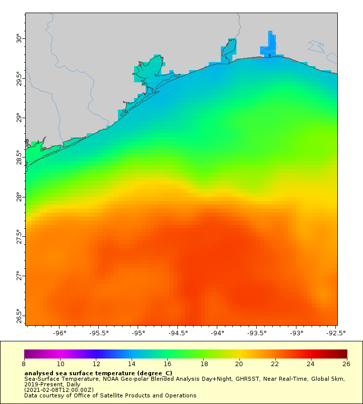
Loop of Sea Surface Temperatures throughout the Event
Photos & Video
 |
 |
 |
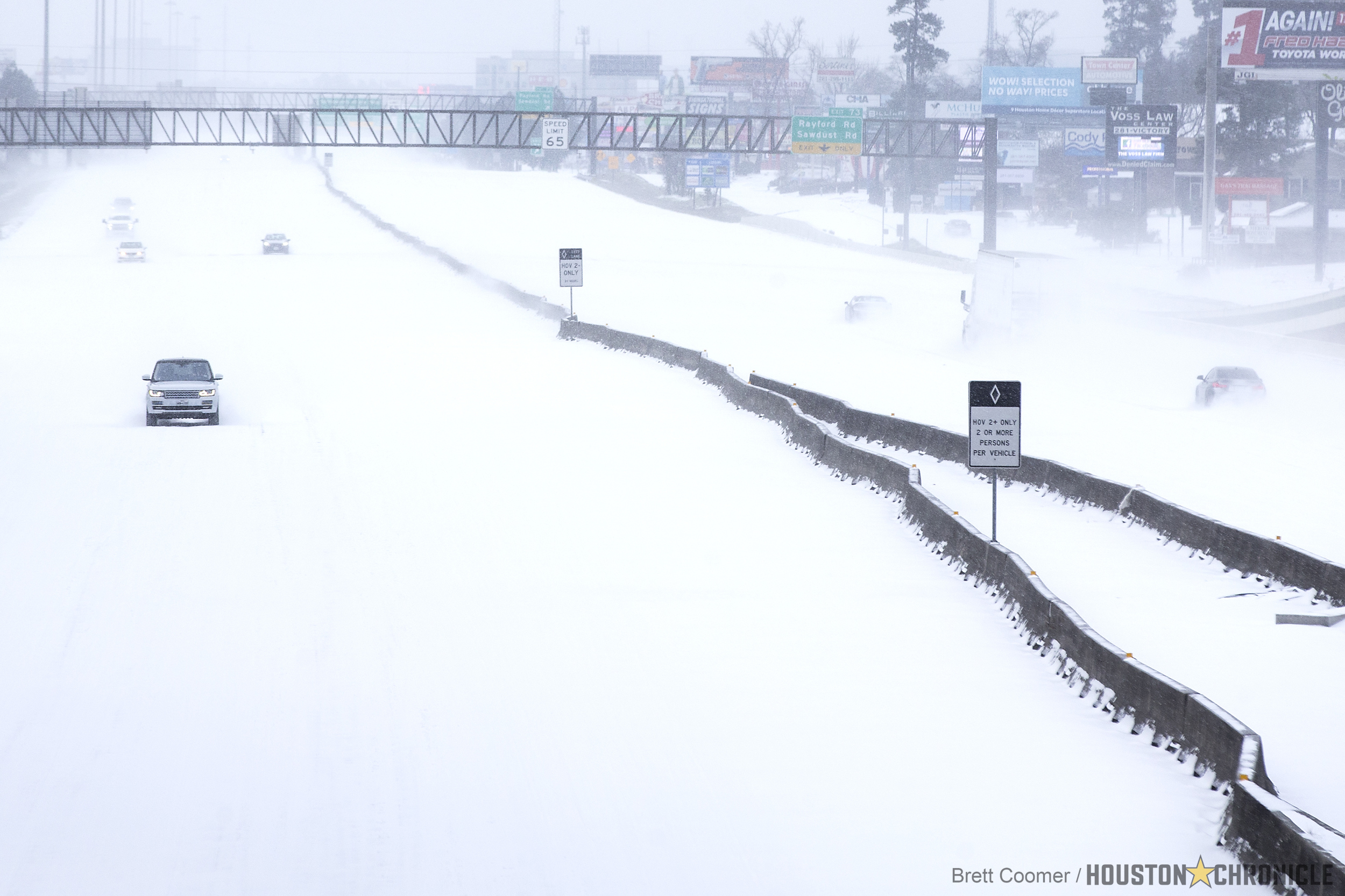 |
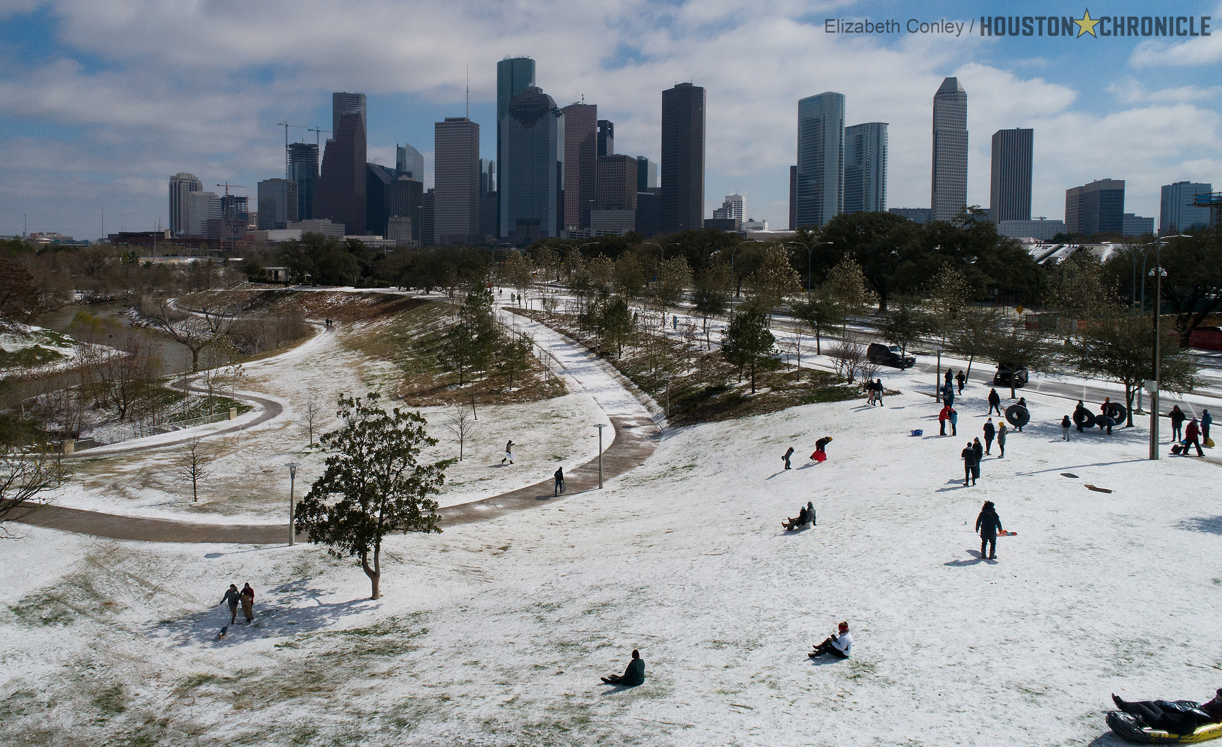
| Snow and ice near Madisonville in Madison County (James Robinson) |
Snow and sleet in Chambers County (Ryan D. Holzaepfel) |
Snowy Skyline of the City of Houston (Elizabeth Conley - Houston Cronicle) |
Snow Packed Interstate-10 near Spring (Brett Coomer - Houston Cronicle) |
 |
 |
 |
 |
| City Hall - City of Bellaire (Cheryl Bright) |
Snow and sleet near Memorial Northwest Division in Harris County (John Paterson) |
Snow Covered Streets in Galveston
(Stan Blazyk)
|
Ice Covered Trees in Bryan (Marcie Gray) |
 |
 |
 |
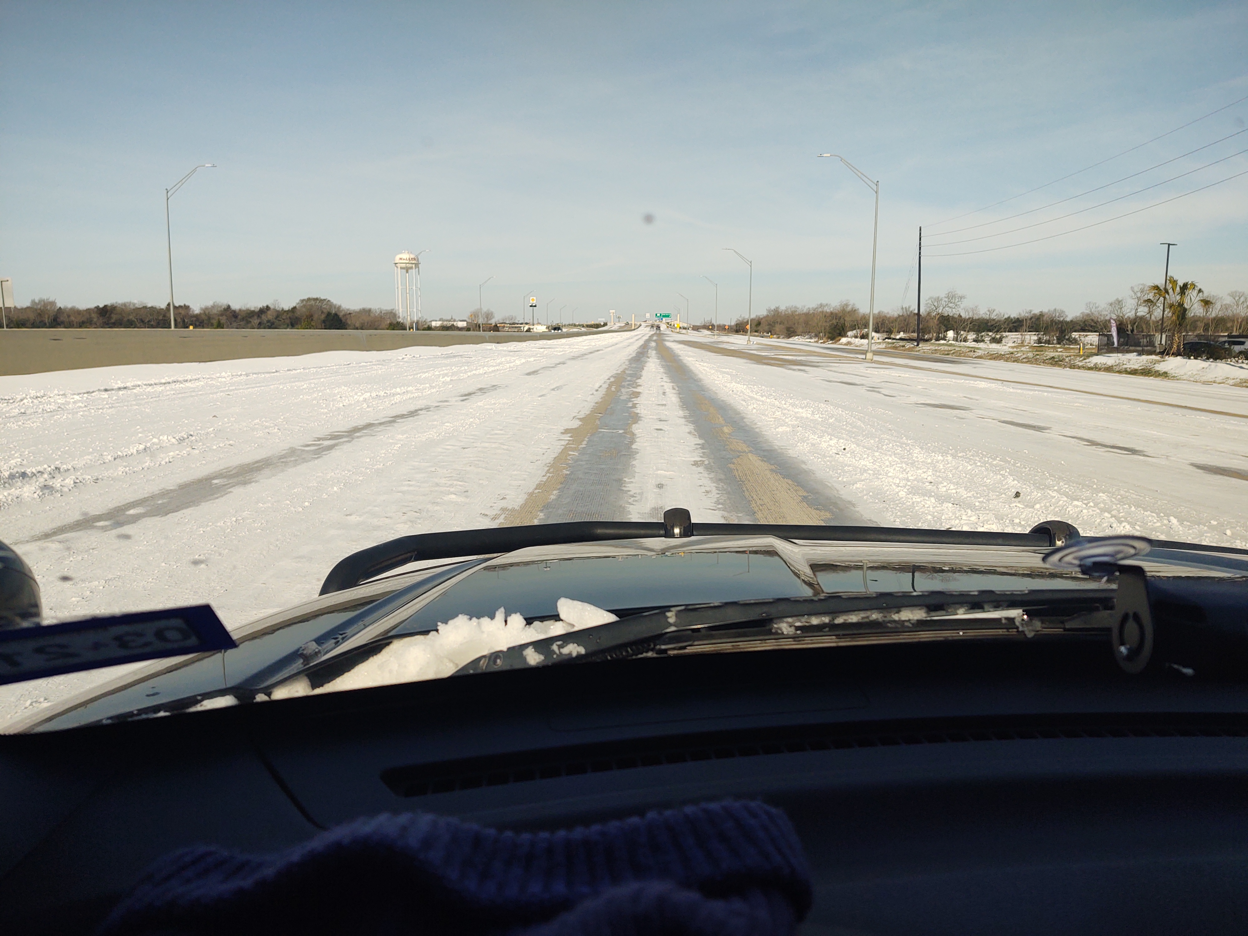 |
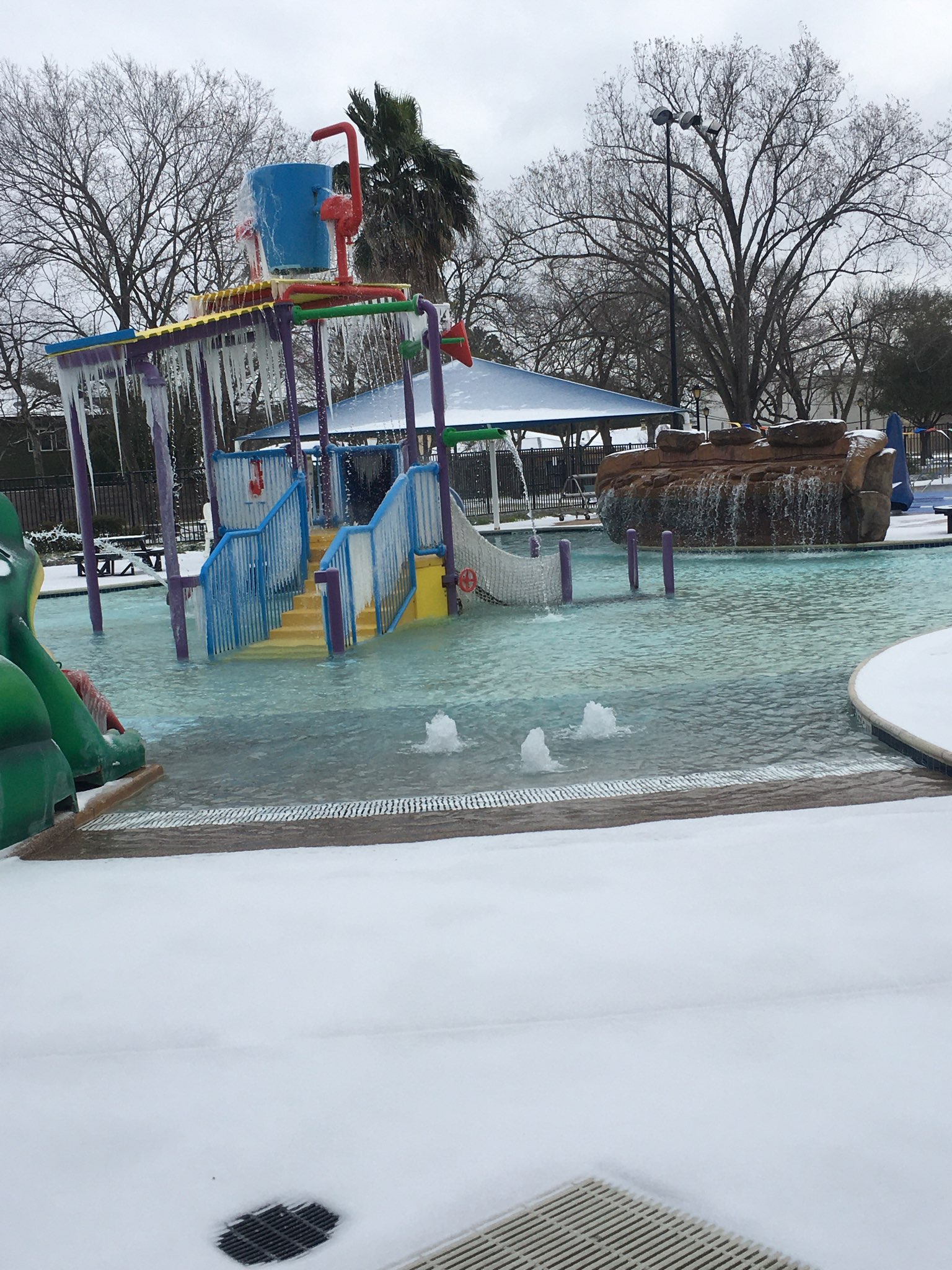
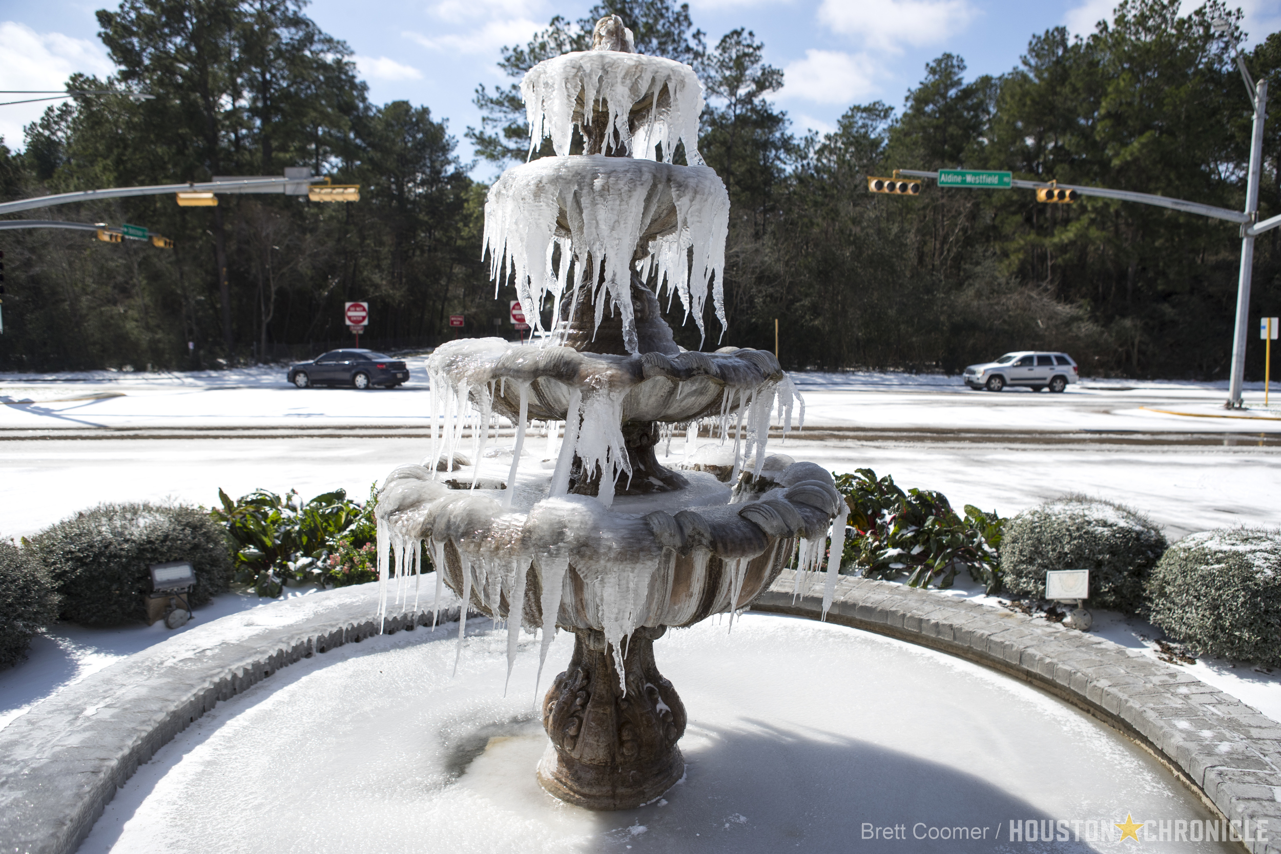
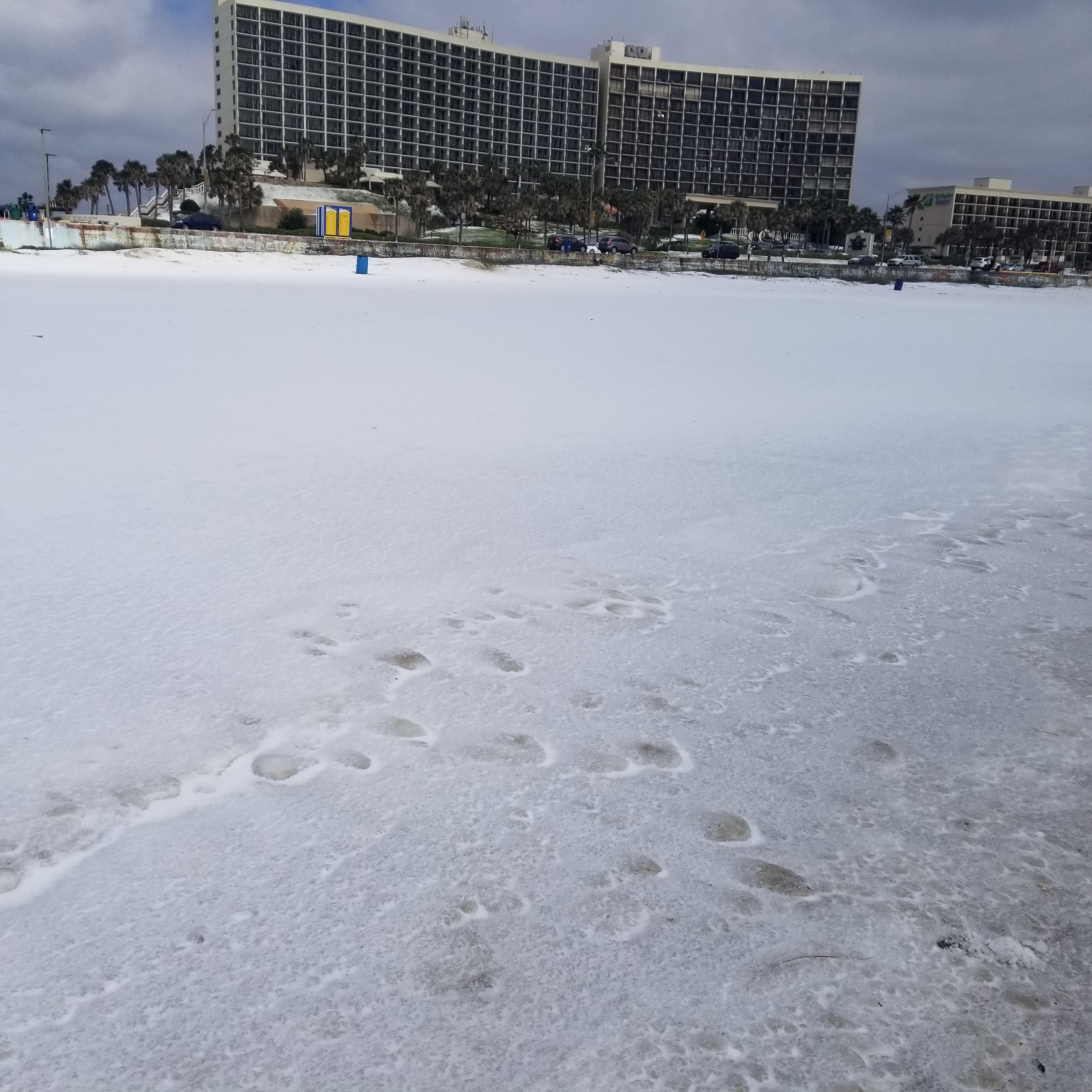
| Frozen Playground in City of Bellaire - Bellaire Town Square Family Aquatic Center (Cheryl Bright) | Frozen Fountain (Brett Coomer - Houston Cronicle | 53rd St Beach looking towards San Louis Hotel in Galveston (Michael Garske) | Highway 290 in Waller County (Dean Hensley) |
Forecast Information


Jump to a day:
Area Forecast Discussion
National Weather Service Houston/Galveston TX
326 PM CST Fri Feb 5 2021
.LONG TERM [Sunday Through Friday]...
…An upper level trough will be moving into Southern California on
Wednesday, but how strong and how quickly it moves west will
determine how the end of the long term period pans out. The GFS is
the weakest and quickest solution bringing the trough across Texas
late Thursday into Friday increasing PoPs Thursday afternoon into
Thursday night, but then drying out through the weekend. The EC has
had the upper level trough stronger, becoming a closed low over the
Baja Peninsula by Thursday evening. This solution brings
precipitation beginning Thursday, but continues it into the weekend
as the stalled boundary stays parked near the area. The Canadian is
a bit in the middle of the road between the GFS and EC, with a
stronger trough moving across Texas on Friday. The real forecast
challenge Thursday night will be how cold it gets. Temperatures will
be flirting with near freezing across the northern tier of counties
bringing the potential for a wintry mixture to those areas. There
are still a lot of uncertainties in this forecast, so temperatures
may trend warmer or cooler through the next few days.
Fowler
Area Forecast Discussion
National Weather Service Houston/Galveston TX
414 AM CST Sat Feb 6 2021
.LONG TERM [Sunday Night Through Saturday Night]...
Partly to occasionally mostly cloudy skies can be expected Sunday
night through Monday night as high pressure moves off to the
east. With this onshore flow, look for warmer temperatures to come
back to the area with inland highs back into the 70s on Monday.
The next cold front will slowly sag into the area on Tuesday and
will bring some cooler temperatures back to the region. This front
should linger somewhere near/along the coast until a stronger
front moves through on Thursday. With these fronts in the area and
mid/upper level disturbances moving across the area, expect
periods of rain in the Wednesday through Thursday night time
period. At this time, it looks like the coldest temperatures will
hold off until Thursday night as the area begins to dry out. Some
models/soundings indicate some support for possible frozen
precipitation for parts of the area on Thursday night before the
drying occurs, and we'll continue to watch how the models handle
this over the next several days. Stay tuned. We are currently
carrying a dry forecast Friday night through Saturday with lows in
the 20s/30s and highs in the 40s.
42
Area Forecast Discussion
National Weather Service Houston/Galveston TX
356 PM CST Sat Feb 6 2021
.LONG TERM [Tuesday Through Saturday]...
We'll be starting the work week on a warm note...with things likely
ending very much colder by the end of the week (as indicated by the
previous forecast for the most part). High pressure well off to the
E/NE will allow for a persistent onshore flow across SE TX Mon/Tues
as low-level moisture levels slowly increase. A nearly zonal flow at
the upper levels are hinting that the cold front (originally slated
for Tues) could have some trouble making it that far south into our
CWA. As a result, will trend high temperatures Mon/Tues warmer with
lower/mid 70s for most inland areas...upper 60s at the coast.
Rain chances are still set to return Weds as disturbances embedded
in the W/SW flow aloft begin moving across the state. This activity
could be enhanced by the lingering cold front, but at this time it
is hard to pinpoint where exactly. But going by these latest runs,
POPs may be best on Wed over our northern counties. These elevated
rain chances are expected to linger through Thurs with the passage
of the second stronger cold front. Have leaned more toward the GFS
and Canadian solutions with this part of the forecast as they have
been verifying a bit better of late. As such, we could be in store
for a couple nights of freezing to below freezing temperatures for
overnight lows for much of SE TX from Thur night into the weekend.
High temperatures for this period could range from the 40s and 50s
if these models do verify. 41
Area Forecast Discussion
National Weather Service Houston/Galveston TX
357 AM CST Sun Feb 7 2021
.LONG TERM [Monday Night through Sunday]...
Temperatures will be on the mild to warm side for a large part of
the area until the arrival and passage of the next cold front
late Wednesday night or Thursday. Highs in the 60s/70s on Tuesday
and Wednesday will cool down behind the front with 50/60s on
Thursday and 40s/50s Friday through Sunday in response to strong
high pressure slowly building into the area from the northwest and
north. There are still some differences in the models (frontal
location/ timing and how cold the airmass gets as the high builds
in) that will have to be closely monitored over the next several
days and could bring some changes to the forecast (including the
possibility of colder temperatures). At this time, the coldest
nights look to be setting up for Friday night and Saturday night
with lows in the 20s/30s.
As for rain, will be keeping the forecast dry until Wednesday
when enough moisture and lift return to the area and begin to
interact with disturbances moving across the state. Rain chances
look to remain in the forecast (highest generally to the north of
I-10 and to the east of I-45) until Thursday afternoon and evening
when the front moves on through and dries the area out. At this
time, the coldest air does not arrive until all the rain has moved
out of the area.
42
Area Forecast Discussion
National Weather Service Houston/Galveston TX
334 PM CST Sun Feb 7 2021
.LONG TERM [Tuesday Through Sunday]...
A persistent onshore flow Tue and Weds will be keeping temperatures
on the mild/warm side for a much of SE TX. While the zonal pattern
aloft will be helping to keep the cold front just north of the CWA
on Tue, there are some hints that the passage of a few upper level
disturbances (via the southern stream jet) could nudge this bound-
ary a bit into our northern zones very briefly late Tues afternoon.
But that being said, will err on the side of warm and keep daytime
highs mostly in the 70s for inland locations both Tue/Weds at this
time. Lows are expected to range from the 50s inland to near 60 at
the immediate coast.
Rain chances will also begin increasing Weds given this heating as
well PWs climbing to 1.3-1.4" and progs of a decent low-level jet.
These elevated POPs are expected to continue into Weds night/Thurs
with the arrival/passage of the cold front across SE TX. Even with
global models remaining sharply divided with regard to how cold we
will get, FROPA timing is trending a little better. That is, we'll
be looking for the wind shift to reach the coast Thur afternoon or
evening per these latest runs. Did include the mention of isolated
thunder in the grids for this time period given the progged sound-
ings of some decent CAPE. As the very cold air mass moves into the
region behind this front, a much colder forecast is on tap through
the rest of the week. Daytime highs Fri/Sat could struggle to make
it into the mid/upper 50s (..and possibly into Sun). We could also
see our coldest temperatures of the season for both Fri and/or Sat
nights. Currently going with overnight low temperatures in the mid
to upper 20s over the northern third of our CWA...at/around freez-
ing for central locations...upper 30s for the coastal counties for
this time period. 41
Area Forecast Discussion
National Weather Service Houston/Galveston TX
416 AM CST Mon Feb 8 2021
.LONG TERM [Tuesday Night through Monday]...
A persistent onshore flow on Tuesday and Wednesday will help to
keep temperatures on the warm side for much of Southeast Texas. It
still appears possible that a cold front that is expected to
remain just to the north of our area could be nudged just a little
southward on Tuesday or Tuesday night resulting in a slight
cooldown behind the boundary for locations way up north. In
general, expect much of the inland areas to see highs in the 70s
for both Tuesday and Wednesday. Some fog (mainly in the late night
through early morning hours) could develop, especially in/around
the Galveston Bay area and near the beaches. Rain chances return
to the forecast Wednesday afternoon and persist until the next
cold front moves through the area on Thursday.
Hope you enjoyed the warmer early February temperatures because
everything changes with the passage of Thursday's front as a
colder airmass filters into the area. Locations up north should
cool down Wednesday night, and the rest of the area will see
falling temperatures during the day on Thursday after the boundary
moves on through. Rains chances will decrease and eventually come
to an end from west to east starting late Thursday afternoon or
early Thursday evening and continuing through Thursday night. Low
temperatures Friday morning are expected to range from the mid to
upper 30s inland to the mid to upper 40s at the coast. Strong high
pressure at the surface will begin building into the area from
the north, and cold air advection is anticipated to help to keep
high temperatures in the 40s/50s on Friday. Lows in the 30s/40s
and highs in the 40s/50s look to persist throughout the weekend
and on into the start of next week as the area remains under the
influence of the surface high. In addition to the colder
temperatures, shortwaves moving across the area will have the
potential to bring us periods of rain. We will continue to monitor the
end of the week and over the weekend temperature forecast for the
possibility of colder readings and some frozen precipitation. 42
Area Forecast Discussion
National Weather Service Houston/Galveston TX
350 PM CST Mon Feb 8 2021
.LONG TERM [Wednesday through Monday]...
Rain chances will be increasing on Weds...with the best POPs across
our N/NE CWA. The combination of a stalled cold front (likely close
to our northern borders) and a developing low/mid level jet as well
abundant daytime heating/low-level moisture (PWs from 1.2" to 1.4")
should support the development of scattered showers/isolated thund-
erstorms by Weds afternoon. As all/most of these features remain in
place, elevated POPs will likely persist into Weds night and Thurs.
However, the main WX story for Thurs will be the arrival/passage of
the strong cold front and the cold arctic air mass filtering down in
to the region in its wake. Did keep the mention of isolated TSRA in
for FROPA with most of this activity likely elevated. Rains will be
ending with the front from west to east by late Thurs afternoon/eve
and continuing through Thurs night.
As it has been hinted at previously, the main forecast issues going
forward will be related to the very cold air mass that's progged to
settle over the region by the end of the week and into the weekend.
Low temperatures Fri morning should range from the mid to upper 30s
inland to the mid to upper 40s along the coast. Strong surface high
pressure building into the state from the north and persistent cold
air advection will help to keep high temperatures in the 40s/50s on
Fri. Temperatures could fall even lower for Sat/Sun by another 5 to
10 degrees for both highs and lows. As such, we could be looking at
a few nights of prolonged freezing or below freezing temperatures.
In addition to these colder temperatures, shortwaves moving across
the area from the SW will have the potential produce some low POPs
Sat/Sun/Mon. And yes, while there are hints that we could see some
frozen/wintry precipitation (per GFS extended runs), confidence not
high enough to include its mention in the grids at this time. 41
Area Forecast Discussion
National Weather Service Houston/Galveston TX
429 AM CST Tue Feb 9 2021
.LONG TERM [Thursday through Monday Night]...
The main concern in the extended is the potential for well below
normal temperatures late this week into next week.
Showers and a few thunderstorms will be ongoing on Thursday as a
mid- upper level trough deepens over western TX and a cold front
slowly moves through during the morning hours. While colder air
begins to filter in by late Wed night, warm air aloft (roughly at
850 mb) should aid to keep rain chances through Thursday night. In
fact, by late morning and afternoon the frontal band becomes more
organized with elevated instability and decent mid-level
frontogenesis persisting along the front. This should aid in
enhancing rainfall rates; therefore, have PoPs likely through at
least, late Thursday night. Rainfall totals are still uncertain,
but 1-1.5 inch amounts cannot be ruled out.
After this front...the fun part begins. The first piece of Arctic
airmass breaks off and settles across the Plains in the wake of
the front. This dry and cold airmass will take highs back down
into the upper 40s to upper 50s by Friday. Even more chilly or
frigid conditions filter in as the main 1044 mb Arctic high over
the Canadian Plains shifts east-southeast across the High Plains.
Our confidence is moderate to high that cold conditions will
arrive to southeast TX; however, there is still uncertainty on the
amount of cold air filtering in. We are still seeing quite a
spread between models with GFS being one of the coldest solutions.
Latest NBM guidance also suggest a very cold weekend with MaxT in
the 30s to low 40s Sunday and from the upper 20 to mid 30s
Monday. Given that, have leaned towards the colder solutions for
temperatures Saturday into Monday and went fairly close to the
25th percentile of climatology. As for now, get ready for a cold
weekend for southeast Texas standards. How cold will it get?
That's the main question, but even if warmer solutions verify it
could still be cold enough at most locations. The main takeaway is
to keep up with the latest forecasts and be prepared to take
action to protect people, vegetation and property (pipes). On the
other hand, confidence on breezy conditions is also increasing
Friday into the weekend, which will help to keep wind chill values
even colder.
Precipitation-wise, a few shortwaves embedded in the
southwesterly flow aloft will move through the region Saturday and
Sunday, therefore, hinting at some precipitation chances. Better
chances look to arrive towards the end of the period as a coastal
low develops and lifts northward into the region Monday into
Tuesday. There could be some light mixed precipitation over parts
of the forecast area with mainly snow-rain mix to our north.
Confidence is very low on this right now as there are a lot of
details to still be worked out. Overall, keep in mind that we are
still 4 to 7 days out so this forecast will change during the week.
05
Area Forecast Discussion
National Weather Service Houston/Galveston TX
339 PM CST Tue Feb 9 2021
.LONG TERM [Thursday Through Tuesday]...
Fairly high rain chances will be ongoing across SE TX on Thurs with
the passage of the strong cold front. The bulk of the precipitation
should be showers, but still cannot rule out isolated thunderstorms
given the modest lapse rates/weak instability. All this activity is
expected to move off the coast with the front by early Fri morning.
Rainfall totals should average from 1/2 to 1 inch over the CWA with
isolated higher amounts from 1 to 1.5 inches possible.
Otherwise, the main forecast issue with this portion of the forecast
looks to be the potential for some very cold/well below normal temp-
eratures for an extended period (Thurs night through Mon night), and
perhaps a slight chance of precipitation during the same time frame.
Progs of a series of strong surface highs moving down from the High
Plains (1041mb to 1047mb) into the Central Plains from Thurs on in-
to the weekend will help maintain a strong/persistent CAA into the
state. Will continue to lean on the side of the colder GFS/Canadian
solutions for our temperatures. This pattern could produce extended
periods of freezing/below freezing temperatures this weekend...with
possibly a Freeze Warning for our coastal counties. Slightly better
consensus/slowly increasing confidence with the likelihood of colder
weather does make this a very good time to remind everyone to check
their cold weather preparations (both inside and outside) for this
potentially prolonged cold snap.
As for the chances of precipitation...models are continuing to show
a series of embedded shortwaves moving across the area through this
weekend. As it usually is with the SW flow aloft, the timing of said
shortwaves is expected to be an issue. Given the very cold air mass
in place over SE TX...there could be some light mixed precipitation
(rain-snow/sleet mix) over the CWA at times during this time frame.
As all of this is still a ways away, confidence remains very low for
this even verifying at this time. 41
Area Forecast Discussion
National Weather Service Houston/Galveston TX
437 AM CST Wed Feb 10 2021
.SHORT TERM [Through Thursday Night]...
At 4am, a shallow cold front was situated from roughly Edna-Wharton-
Houston-Cleveland. It should remain in that general vicinity for
most of the day. Some guidance drifts it north a touch, others
(primarily the hires guidance that was heavily weighted) sags it a
bit further south. South of the boundary, dense sea fog has rolled
back in. Visibilities will again improve inland during the mid-late
morning hours, but not so much along the beaches and offshore.
Moist southerly flow just above the sfc will be transporting an axis
of higher PW's into the region. Expect some sct pockets of -ra to
begin developing this morning near the boundary...eventually
increasing in coverage and becoming more showery further to the
north during the day. Can't completely rule out an iso tstm, but
it'll be the exception rather than the rule.
Somewhat of a break in precip is anticipated for most areas late in
the day, but anticipate some additional sct development across the
area later this evening...mainly near and just to the north of the
frontal boundary as it begins a southward push toward and off the
coast.
Heading into to Thurs, western trof will be making ewd progress
closer to the area. We should still have some respectable PW's in
the 1.2-1.5" range in place the region. Increasing large scale lift
(and a series of impulses embedded in the swly flow aloft and
favorable jet position) should allow precip to increase in areal
coverage thru the day Thurs and Thurs night. May see some elevated
tstms mixed in...and also some periods of training moderate rains at
times Thurs night. In general, 0.75-1.75" of rain can be expected in
the Thur-Thurs night time period. Grounds should be able to handle
this without much of an issue considering it'll be spread out over a
fairly long duration, but always need to keep an eye on the rain
rates for any very localized issues that may crop up in association
with any training. 47
.LONG TERM [Friday through Tuesday Night]...
Cold to frigid conditions along with a chance for mixed
precipitation are the main story in the long term forecast.
Other than perhaps some lingering showers across our far
east/coastal zones Friday morning, the day should be relatively
dry. At the surface, CAA continues to filter in drier and colder
air, leading to daytime temperatures from the mid 40s to mid 50s.
This is 10 to 20 degrees below normal/average. Overnight lows will
range in the 30s and low 40s. By Saturday morning, the next
shortwave embedded within the southwesterly flow will allow for
increasing lifting and saturation along the BL, especially across
our western counties. Forcing, on the the hand, diminishes/weakens
as the shortwave moves east/southeast. Therefore, have only light
precipitation chances.
The scenario turns a bit more interesting as we head into Sunday
and early next week. The synoptic pattern aloft will be dominated
by a shortwave trough across central/southeast TX, a Canadian low
wobbling between the Great Lakes and the International Border,
and a low developing over the Pacific Northwest. The evolution of
this upper low is the one we should continue to monitor over the
coming days. This upper low will quickly progress across the
southern Rockies/central TX by Sunday, moving across the forecast
area on Monday. The environment will be favorable for widespread
precipitation as the region will be situated in a favorable
region of the upper level jet, with increasing PVA and decent
southerly LLJ. Will continue to monitor this system as models also
hint for some mid-level frontogenesis; however, the layer above
still remains more stable. With that being said, an unsettled
start to the week is likely. The main question will be p-types.
Latest guidance indicates that surface temperatures will likely
drop to near freezing across our northern/western counties,
bringing a wintry mix and/or freezing rain throughout the day.
Precipitation should quickly taper off by Monday night as a
strong surface high builds in. Well, to make matters worse, breezy
northwesterly winds will be possible, causing wind chill values in
the teens and 20s possible.
Speaking of cold....Significantly cold conditions are expected
this weekend into next week, with record breaking cold forecast.
The strong and amplified Arctic high will dive southward across
the Plains and into our region. While confidence is increasing,
there is still uncertainty on how cold southeast TX will get.
Continued with a cold forecast and went close to the mean and/or
coldest solutions from Day 4 - 7. Even chilly or frigid conditions
will be possible Monday night into Tuesday. Have leaned towards
raw deterministic and ConsALL for lows during this time-frame to
produce temperatures in the teens and 20s.
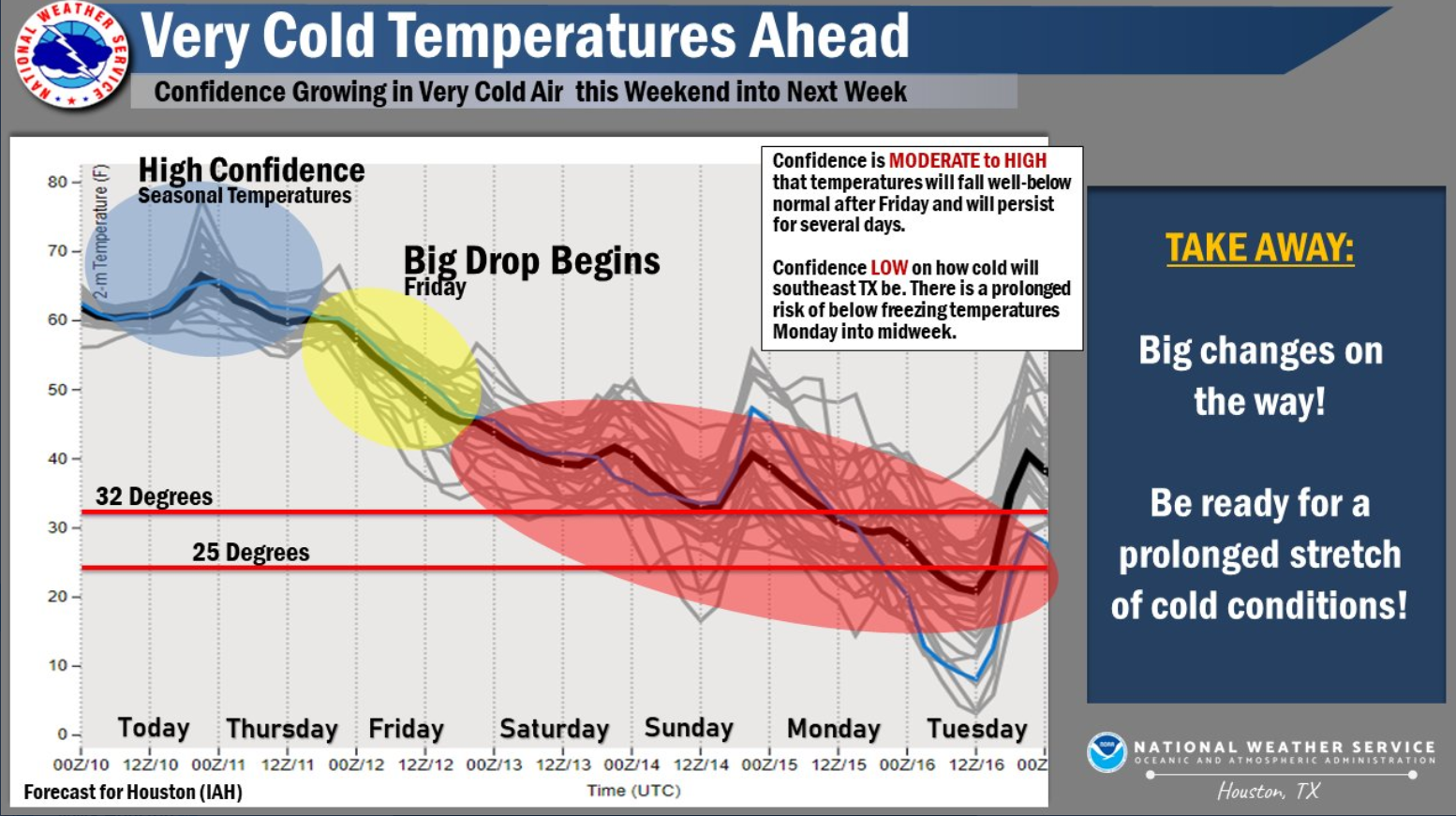
Key Messages:
1) Big changes on the way! A prolonged stretch of cold and winter
weather will be possible late this week into next week with
temperatures well below average for this time of year.
2) Precipitation chances increase late Sunday into early next
week with a potential for a wintry mix. Confidence is moderate in
terms of a wet/unsettled pattern during this period; however,
uncertainty arises on the type of precipitation.
3) A prolonged period of very cold conditions will be possible.
Be prepared to take action and protect people, plants, and
properties (pipes). We encourage you to monitor the forecast over
the next days for the latest information and/or possible
headlines.
05
Area Forecast Discussion
National Weather Service Houston/Galveston TX
418 PM CST Wed Feb 10 2021
.LONG TERM [Friday through Wednesday]...
Rain chances will be decreasing Fri morning through the afternoon
as the cold front pushes well into the Gulf. Strong high pressure
building down from the Plains will help to usher in a very arctic
air mass into the region at this time with frigid conditions exp-
ected to persist through the weekend and and at least through the
first half of next week. The other part of the story for the long
term portion of the forecast will be the increasing likelihood of
wintry precipitation mixed into all of this..lower chances on Sat
and perhaps higher chances Sun night/Mon.
Global models are continuing to trend cold for the weekend...then
even colder during the early part of next week as the strong/amp-
lified Arctic surface high is progged to track south in the Great
Plains. Did not go quite as low as some of the MOS has suggested,
but record lows will be entirely possible.
As for rain chances, models appear to be in decent agreement with
the timing/strength of these systems. The first shortwave appears
to move through SE TX on Sat, but with not so favorable low-level
moisture levels and upper support. Did include the mention of ice
pellets/sleet and freezing rain for mainly the far northern parts
of the FA for Sat morning/afternoon. Otherwise, will be expecting
isolated to scattered cold rains. However, things seem to be more
favorable for increased POPs for Sun night/Mon. The possible dev-
elopment of a coastal low and divergent jet structure aloft along
with the strong shortwave are all pointing to much better chances
for precipitation. The main question then becomes p-types. Latest
guidance indicates that surface temperatures will likely drop to/
near freezing across our northern/western CWA by midnight Sun, so
we'll be starting off with freezing rain/wintry mix overnight. As
temperatures continue to fall early Mon, this could transition to
more of a snow/wintry mix through Mon morning. And so...the morn-
ing commute on Mon could be a very tricky one.
Looking even further ahead...guidance not really offering up much
by way of warming and/or drying. There are hints of another round
of rain/wintry mix for SE TX with the passage of yet another very
strong cold front and its associated shortwave. *whew* 41
Area Forecast Discussion
National Weather Service Houston/Galveston TX
436 AM CST Thu Feb 11 2021
.SHORT TERM [Through Friday Night]...
**If traveling across northern parts of the Brazos Valley today
and tonight, be careful on bridges. There may be a few slick
spots should temperatures fall another couple degrees today**
Enhanced lift in association of upper trof over northern Mexico,
upper disturbances in the swly flow aloft and a moist srly flow
over the cold airmass at the sfc will aid in increasing precip
development today and tonight. There's some instability aloft so
there will probably be some elevated tstms mixed in as well. Best
lift should be realized across the northern half of the CWA
between now and early evening closer the RRQ of upper jet and
convergent zone near H85. We will be closely monitoring temps in
the Brazos Valley today. Currently they're in the 33-36F range and
doubt they'll see much if any of a warm-up. Some guidance drops
the temps another few degrees. Should this occur, can't rule out
some patches of ice on elevated bridges and surfaces. Think best
chances of this occurring will be just n/nw of our CWA, but too
close for comfort. Depending on trends, the dayshift may need to
evaluate the need for a winter wx advisory. Precip should mostly
taper off there early in the evening as it heads toward the
US59/I-69 corridor and eastward into the overnight hours. Bulk of
precip should end slightly after midnight, though fcst soundings
remain saturated in the llvls so would anticipate some areas of
drizzle continuing into Fri morning. Again...will need to keep a
close eye on this across the Brazos Valley as readings remain near
the freezing mark.
Sct areas of -ra/dz will probably persist into Friday across
southern parts of the region closer to the coast with continued
isentropic lift. Otherwise, cloudy and continued cold heading into
the weekend and into next week when the fun really begins... 47
.LONG TERM [Saturday through Wednesday Night]...
The main focus in the long term continues to be a prolonged
period of well-below temperatures and multiple chances for mixed
precipitation.
The Arctic blast is on the way with the coldest readings expected
after Sunday. Latest forecast guidance keeps the strong surface
high building over west/central Canada through Saturday, shifting
southward into the Plains Sunday through much of next week.
Temperatures were adjusted a few degrees colder than NBM guidance
and went fairly close to the 10th-25th percentile through the
period.
There are multiple rounds of precipitation during the period. The
first mid-upper level wave arrives Saturday into early Sunday.
While dynamics largely remain west and north of the area in terms
of legitimate precipitation, the system will drive a decent PV
anomaly enough to produce precipitation. At the moment, thermal
profiles would support rain as the primary p-type. While
confidence is low, a brief window of patchy freezing drizzle will
be possible across our far northwestern counties early Saturday
morning and early Sunday.
Attention then turns to a more potent system tracking across the
Rockies from the Pacific Northwest on Sunday. Latest guidance
suggests a slightly weaker system compared to previous runs;
however, models are in good agreement on its phase/timing. In
fact, models are now bringing a more progressive low, bringing
precipitation as early as Sunday night, moving out of our region
by early Monday evening. There is still a lot of uncertainty with
this system, though this storm has the potential to bring an
assortment of hazards, including rain, freezing rain, sleet, snow
and wind. Given warm air aloft, a wintry mix looks possible,
mainly across our half southern counties (mainly south of I-10).
Timing will be very important! If precipitation moves quick enough
to make it across southern/coastal areas before temps cool
near/below freezing, then rain/freezing rain/sleet will be
favored. Will continue to monitor different factors such as wet
bulb temperatures, lifting aloft and timing of stronger CAA
filtering in behind the system. Strong lift could result in
stronger cooling and a more rapid changeover to snow. No matter
the type of precipitation, a hazardous morning commute looks
possible.
Beyond Monday...models show another system with a potential for
winter weather conditions on Wednesday, but there is too much
uncertainty this far out.
Key Messages:
1) An extended period of well-below normal temperatures is
expected this week into next week. Wind chill values may drop into
the teens and single digits at times.
2) Precipitation chances continue to increase now from Sunday
into early next week with a potential for a wintry mix. Confidence
remains low on the type of precipitation.
3) Stay weather aware and prepared. We encourage you to begin
preparing for these conditions including winterizing your homes.
Continue to monitor the forecast over the next days for the latest
information and/or possible headlines.
05
Area Forecast Discussion
National Weather Service Houston/Galveston TX
320 PM CST Thu Feb 11 2021
...MAJOR WINTER IMPACTS EXPECTED ACROSS SOUTHEAST TEXAS THIS WEEK...
...Sunday night plan on staying where you are with travel being
impacted to severe impacted through Tuesday morning...
.SHORT TERM [Tonight through Friday Afternoon]...
Winter weather advisory for the northwesternmost counties extended
until 10 pm.
Cold front has pushed out well south of the coastal waters and
winds have come up a few knots moreso with gusts - 15 to 20 mph
sustained with wind chills of 29 to 37 were commonplace at 2 pm.
Short wave moving through the Hill Country is producing more
widespread wintery precipitation over the Hill Country and the
eastern edge will impinge on SETX late this afternoon and tonight
as the s/w shifts eastward. More widespread liquid rainfall is
expected across SETX late this afternoon and tonight spreading
east then southeast tonight and tapering off from the northwest.
Areas across Madisonville to Caldwell will continue to have patchy
freezing light drizzle/freezing rain/sleet/rain into mid evening
before it tapers off. The advisory is set to expire at 10 pm but
temperatures at 10 pm may hold at 30-33 degrees there which would
indicate that any icy roads may not improve even though the
precipitation (and Advisory) have ended. Low temperatures
overnight will be a slow slide down to 30-37 north of I-10 and
38-42 south of I-10.
Friday morning the rain should be confined to mainly the 59
corridor southeastward with scattered/numerous showers and
isolated thunderstorms possible well offshore near the 850 front.
But inland in the afternoon it should be just chilly with some
patchy light rain in the upper 30s/lower 40s.
45
.LONG TERM [Friday Night Through Thursday]...
*** OVERVIEW ***
* Surge of Arctic air arrives on Saturday with temperatures
approaching freezing across most of the area by Sunday night.
* First of two disturbances arrives on Saturday, bringing mostly
rain with higher chances of mixed precip north of I-10.
* Second system arrives late Sunday into early Monday. With
colder temperatures in place, widespread wintry precipitation could
impact most of the area during this time.
* Behind the second system, prolonged stretch of below freezing
and potentially historically low temperatures will last well into
next week. Another round of precipitation may arrive by mid-week.
A highly impactful and potentially historic period of prolonged cold
temperatures with multiple episodes of winter precipitation is
expected to impact SE Texas over the next week. With persistent deep
surface high pressure in place over the central CONUS, arctic air
will continue to push into the area as we head into the weekend. By
Saturday, high temperatures are unlikely to break out of the mid-40s
with lows approaching freezing north of the Houston metro. Our first
shot at winter precipitation will arrive on Saturday evening as an
upper shortwave trough pushes through the area. Precipitation type
will be highly dependent on the timing of this feature, though a
period of freezing drizzle/mixed-phase precipitation may occur north
of the Houston metro but elsewhere to the south model soundings
continue to favor a cold rain.
Our main area of focus continues to be the arrival of a second, more
amplified shortwave on late Sunday into early Monday. As this
feature pushes towards SE TX and develops a slight negative tilt,
GFS/EC solutions indicate the formation of an associated coastal low
over the western Gulf of America. PWs will remain in the vicinity of
1-1.25 in as this feature continues to develop, and model soundings
remain well-saturated. With lows on Sunday evening expected to dip
into the 20s to low 30s across the overwhelming majority of the
area, an impactful winter precipitation event is anticipated. While
precipitation type will remain highly dependent on the timing of
this system's arrival and the exact vertical temperature profiles
present across the area (i.e. the presence and extent of an elevated
warm layer), we are becoming increasingly confident in a widespread
mixed-phase event beginning Sunday night and persisting into Monday.
Global deterministic solutions continue to indicate the possibility
of snow, sleet, and freezing rain impacting portions of the area
during this time. This will make for a particularly hazardous
commute on Monday, particularly for those who travel on elevated
roadways or bridges. Surface streets may become involved as well
given these persistent cold temperatures. Travelers are urged to
pay close attention to the latest forecast as this situation
develops. Over the next few days, timing, amounts, and types of
precipitation will become more refined as higher- resolution
guidance becomes evaluable.
Upon the exit of the second system and subsequent clearing, SE TX
looks to experience its coldest night in many years on Monday
evening. Low temperatures across the Brazos Valley and other
northern zones remain progged to drop into the single digits, while
the Houston metro is expected to reach the low to mid 10s. Along the
barrier islands and coast, temperatures will still remain well below
freezing. Daily records are likely in play for several days at each
of our climate sites. These conditions will be extremely hazardous
to the "4 Ps" - people, pets, plants, and pipes. Consider the
actions you will need to take to ensure the protection of each of
these things. Risk may be further compounded by the possibility of
power outages given the expected winter precipitation earlier in
the day and increased energy demand for the heating of buildings.
Freezing temperatures are expected to last well into the upcoming
week, with lows remaining in the 20s for at least parts of the area
through next Thursday. Another episode of winter precipitation is
possible on Wednesday/early Thursday as a third upper trough pushes
through the area, though the timing of this system and temperature
profile across the area remains highly uncertain across model
solutions.
Now is the perfect time to prepare for this period of hazardous
weather. Be sure to have multiple ways to receive weather
information and continue to monitor the forecast, particularly if
you must travel this weekend and early next week.
Cady
Area Forecast Discussion
National Weather Service Houston/Galveston TX
531 AM CST Fri Feb 12 2021
.SHORT TERM [Today Through Saturday]...
Currently, most showers remain offshore of our region with
overcast skies and low clouds expected to persist throughout
today. Hi-res models suggest the highest rain chances will remain
offshore and along the coast due to a lingering frontal boundary
with perhaps some isolated and sporadic showers inland. High temps
will be in the upper 30s for our northernmost counties and the
lower-to-mid 40s everywhere else. Overnight lows tonight will be
only a few degrees colder than today's high temps with our
northernmost counties reaching near freezing and everywhere else
reaching the upper 30s.
As rain chances begin to increase on Saturday due to an
approaching upper-level shortwave trough, high temperatures are
not expected to breach the mid-40s. Global models have been
predicting warmer temps at the surface than what is expected, plus
diabatic cooling from precip can also cool the lower levels.
Therefore, depending on the timing of this precip, cold rain is
expected for most of our region, but periods of freezing drizzle
and other mixed-phase precip north of the Houston-metro area
cannot be ruled out.
.LONG TERM [Saturday Night Through Friday]...
*** OVERVIEW ***
* Bitterly cold air will be moving into the region into midweek as
an Arctic airmass spills into the area. Prolonged periods of
freezing temperatures are expected.
* 3 separate weather systems are forecast to move across the
area...each bringing chances of some wintery precipitation to
parts of the region.
* The combination of both the cold temperatures and winter
precipitation have the potential to significantly impact life and
property. Travel may be impacted by hazardous road conditions.
Sporadic power outages will be a possibility should we have
significant amounts of ice build up on powerlines and/or trees.
Pipes (including sprinkler systems) will be subject to bursting if
not adequately insulated, and hypothermia may be a possibility for
those exposed and not dressed accordingly. Residents should use
the next few days to prepare before the coldest air arrives.
Remember the 4 P's: pipes, people, pets and plants. In addition,
be aware of space heater dangers if not properly place/used.
The first of the 3 systems will be arriving early Saturday evening
and overnight. The trof seen on w/v imagery over cntl Ca will dip
into northern Mexico then across the area. Temperatures, generally
north of Highway 105 will be near or below freezing as this occurs
and some freezing rain and sleet can be expected. Though overall
precip amounts shouldn't be all that impressive from a numbers
standpoint, it only takes a small glaze on the roads to cause
issues. Current forecast frozen accumulations are currently slightly
below Winter Storm Warning criteria, but wouldn't be surprised if a
Winter Weather Advisory might be needed at some point in the area
described above.
The second system is still on target to move in from the w/nw in the
midnight-noon timeframe Monday. This system will bring more
significant widespread frozen precip accumulations...perhaps as far
south as the coast. All combinations of wx are expected...starting
out as a ran-freezing rain-sleet event transitioning to a sleet-snow
mix across some inland portions as it exits the area. Consensus is
building that it'll be a somewhat progressive system - but not a fan
of starting out with ice covered with sleet/snow on top. Suspect a
Winter Storm Watch will be needed at some point this weekend
followed by a Warning for most of the area...assuming no significant
forecast changes between now and then.
Extremely cold air will filter into the area behind it with temps
falling thru the day and night. Lows are forecast to dip into the
single digits across northern parts of the CWA, teens into the
northern coastal counties and 20-25 at the beaches. Monday night/Tue
morning should be the coldest of the week. That said, some locations
might not see readings above the freezing mark for long durations.
As a rough estimate: northern parts of the CWA Mon morning til maybe
Wed morning, I-10 corridor Monday morning til maybe late Tue
afternoon (and only briefly til they fall again overnight), and
the beaches Mon morning til late Tue morning.
The third system, sometime between late Tues night and Wed night
depending on your model of choice, looks like a more traditional
sleet-snow setup with a coastal low positioned closer to the coast,
upper trof approaching from the west and favorable thickness values
dipping into the region. Have the least fcst confidence in regards
to the timing/details with this system of the three considering it's
so far out and lacks model consistency. 47
Area Forecast Discussion
National Weather Service Houston/Galveston TX
352 PM CST Fri Feb 12 2021
...Major Winter Storm Arrives Late Sunday...
.SHORT TERM [Tonight Through Saturday Afternoon]...
Tonight will be cold and cloudy with northerly winds 10 to 15 mph
and temperatures holding in the 30s inland and near 40 on the
coast. Some very light drizzle is possible this evening. A s/w
approaches from the southwest Saturday and rain chances increase
from the southwest to northeast throughout morning-afternoon
hours. Some of the far northwestern areas could see some patchy
light freezing drizzle toward sunrise into the afternoon.
Temperatures should reach the 32-34 degree range for a few hours
near College Station Saturday afternoon ending the freezing
drizzle threat.
45
&&
.LONG TERM [Saturday Night Through Friday]...
*** OVERVIEW ***
* As frigid arctic air pushes into SE Texas, 3 storm systems
are expected to bring periods of winter weather to the
region over the next 5-7 days which will have the potential
to pose a significant threat to life and property.
* The arrival of the first system will bring periods of sleet
and freezing rain on Saturday night/early Sunday with the
greatest impacts north of the I-10 corridor.
* A second, stronger disturbance combined with much below-
freezing temperatures will bring sleet, snow, and freezing rain
to all of SE Texas, causing significant disruptions to travel
and potential power outages. Near record cold temperatures will
develop as this system departs by Monday night.
* A third round of sleet and freezing rain is possible Wednesday
into Thursday, though uncertainty surrounding this system
remains higher.
We continue to expect a significant and potentially historic period
of prolonged subfreezing temperatures with several rounds of winter
precipitation to impact SE Texas over the next week. As a persistent
deep area of surface high pressure remains the dominant synoptic
feature over the central third of the CONUS, moderate to strong
northerlies will continue to enhance CAA, with temperatures
remaining on a downward trend over the next several days. By late
Saturday, most locations will be at or near freezing with the
northern third of the area likely to see the 20s.
The first of three upper shortwaves will traverse the area late
Saturday. Forecast soundings continue to be indicative of
sleet/freezing rain north of the Houston metro with a well-
saturated column and fairly deep elevated warm layer. Surface
/near-surface temps across and south of the metro area will be
less favorable for frozen precipitation, but travelers should
still remain highly vigilant of road conditions before heading
out. Behind the departure of this system, temperatures warm back
above freezing on Sunday afternoon but will remain well below
normal for mid-February (high 30s-mid 40s).
The main period of concern continues to be Sunday night through
Monday afternoon. As a second amplifying trough digs into central
TX, an associated coastal low will develop at the surface and push
into the central Gulf by late Sunday. Ample moisture associated with
this feature combined with subfreezing ambient conditions will
prove favorable for periods of snow, sleet, and freezing rain to
impact all of SE Texas. The most concerning period continues to be
the morning hours of Monday, where model soundings within Houston
metro show a highly favorable profile for freezing rain. In general,
precipitation should begin as mainly rain late on Sunday,
transitioning to sleet/freezing rain overnight and finally becoming
a mix of snow, sleet, and/or freezing rain during the day on Monday.
Snowfall accumulations will reach around 1-3", mainly to the north
of the Houston metro. Ice accumulations of 0.10 to 0.25" are
possible across the metro northward with lower amounts southward.
This complex period of winter weather will create extremely
hazardous roadway conditions, particularly on Monday morning. Non-
essential travel should unequivocally be avoided during this time.
Snow accumulation and significant icing will cause widespread
impacts to road networks. Plan to remain where you are on Sunday
night for at least all of Monday.
As the second system departs and clearing occurs, we'll enter what
will likely be the coldest night across SE Texas in approximately 30
years. Lows will dip into the single digits at most locations north
of I-10, with locations to the south reaching the 10s to lower 20s
along the coast. Temperature records are likely to fall. All
residents of SE Texas should begin to take steps to protect the 4 Ps
- people, plants, pets, and pipes. Due to the combined strain of
increased energy demands due to cold temperatures and previous
winter precipitation, there is also a distinct chance of power
outages during this time.
We continue to monitor the development of a third system which may
bring additional freezing rain/sleet to the area on Wednesday and
Thursday. Given the timeframe and differences in model solutions,
there continues to be uncertainty surrounding this event. However,
there remains the potential for additional disruption due to winter
precipitation to occur through mid-week.
Now is the time to prepare for this period of hazardous weather. Be
sure to have multiple ways to receive weather information and
continue to monitor the forecast.
Cady
Area Forecast Discussion
National Weather Service Houston/Galveston TX
455 AM CST Sat Feb 13 2021
.SHORT TERM [Tonight Through Sunday]...
Due to overcast skies and cold air advection, today's and
tomorrow's high temperatures will struggle to reach near freezing
for areas north of Harris County and West of Fort Bend County.
Everywhere else is expected to reach highs near 40. Overnight
lows tonight will be below freezing north of I-10 and outside of
the Houston-Metro area. Remaining areas will hover near freezing.
An approaching shortwave trough from the southwest will gradually
bring rain chances starting this afternoon as it pushes east
across our area. With forecast soundings indicating a well-
saturated column below 700mb, a brief elevated warm layer, and
surface temps hovering near freezing, freezing drizzle and some
form of wintry mix are possible with these passing, isolated
showers. Highest chances for this wintry mix and winter precip are
north of I-10 and the Houston-Metro area. KBL
.LONG TERM [Sunday Night Through Saturday]...
...Frigid, life and property threatening winter weather is expected
into Thursday...
* Bitterly cold air will continue moving into the region into
midweek as an Arctic airmass spills into the area. Prolonged
periods of below freezing temperatures are expected - even at the
beaches.
* 2 weather systems (one Sunday night-Monday morning and another
toward midweek) will produce winter precipitation across many
parts of Southeast Texas.
* Travel will be impacted by hazardous road conditions. Sporadic
power outages will be a possibility where ice builds up on
powerlines and/or trees. Pipes (including sprinkler systems) will
be subject to bursting if not adequately insulated, and
hypothermia may be a possibility for those exposed and not dressed
accordingly.
* Residents complete should complete preparations before the coldest
air and widespread frozen precipitation begins arriving Sunday
evening. Remember the 4 P's: pipes, people, pets and plants. In
addition, be aware of space heater and generator dangers if not
properly placed/used.
Sunday night-Monday morning storm system:
Still on track to move across the region. Winter Storm Warnings and
Watches remain in place across all of the region. The Watches will
be upgraded at some point later today or tonight assuming no earth
shattering forecast changes. The same general forecast reasoning
remains in place from previous several days worth of discussions so
won't rehash that. Look for rain-freezing rain to transition to a
mix then eventually snow as it exits. Not an ideal situation
whatsoever starting out with ice and expect this to cause numerous
impacts across the region. Precip will taper off by early afternoon.
Changes/tweaks made to the ongoing forecast include increasing snow
amounts, especially n/nw of Highway 59 where fcst soundings show the
warm nose eroding faster. Have storm totals of 3-4" across northern
parts of the area tapering down to around 1/2" just south of I-10
(this on top of ice). Though differing details between guidance,
several indicate the potential for significantly higher amounts with
banding and frontogenesis. Some models show prime upper jet
orientations to enhance over lift as well - but vary by model (LFQ
or RRQ). Also tweaked high temps down into midweek considering
frozen accumulations on the ground and lack of significant heating.
Highs for the day Monday will occur first thing in the morning
followed by continued falling readings thru the day. Bone chilling
readings in the single digits north and teens to low 20s coast are
expected Monday night.
Tue night-Thurs system:
Heading into Tues night and Wed, a sfc coastal trough will begin
developing in advance of the next upper trof fcst to push thru later
this week. This will transport moisture back overhead. Look for
precip to begin developing Tue evening then expand in coverage
overnight and Wednesday. A mixed bag of precip is anticipated,
depending on geographic location and model of choice. Didn't dig too
much into the specifics with this system considering it's many days
away and guidance is bound to change a million times between now and
then. But, the potential is there for additional accumulations and
associated impacts especially further inland from the coast where
the thermal profile will be better.
Precip should clear out ~Thurs evening followed by a gradual warm-up
next weekend. 47
Area Forecast Discussion
National Weather Service Houston/Galveston TX
403 PM CST Sat Feb 13 2021
...Frigid, life and property threatening winter weather is still
expected to develop across much of Southeast Texas into Thursday...
.DISCUSSION...
* Bitterly cold air will continue moving into the region into
midweek as an Arctic airmass spills into the area. Prolonged
periods of below freezing temperatures are expected - even at
the beaches.
* Two weather systems (one Sunday night-Monday morning and
another toward midweek) will produce winter precipitation across
many parts of Southeast Texas.
* Travel will be impacted by hazardous road conditions. Sporadic
power outages will be a possibility where ice builds up on
powerlines and/or trees. Pipes (including sprinkler systems) will
be subject to bursting if not adequately insulated, and
hypothermia may be a possibility for those exposed and not dressed
accordingly.
* Residents should complete preparations before the coldest air
and widespread frozen precipitation begins arriving Sunday
evening. Remember the 4 P's: pipes, people, pets and plants. In
addition, be aware of space heater and generator dangers if not
properly placed/used.
&&
.SHORT TERM [Tonight Through Monday]...
Temperatures so far today have been hovering around or slightly below
freezing across our northwest counties, mid to upper 30s central and
lower to mid 40s coast. Almost nothing has been showing up on radar,
but that will change beginning tonight as the first disturbance moves
across the area and produces frozen precipitation north (where lows
will be near or slightly below freezing) and rain to the south (where
temperatures above freezing are expected). At 9 PM, the Winter Storm
Warning begins up north, and the Winter Storm Watch begins down south.
For the most part, light accumulations are expected overnight through
much of tomorrow morning with this first system, but any accumulations
in/near the warning area will lead to hazardous conditions.
High resolution models coming in are painting a potentially very dangerous
winter weather event over at least the next 48 hours (through Monday),
and with a long period of below freezing temperatures, very dangerous
conditions look to be setting up for parts of the area Tuesday through
Thursday night (see the Long Term section below).
The stronger system begins tomorrow afternoon and peaks tomorrow night
through early Monday morning. The Winter Storm Watch is upgraded to
a Winter Storm Warning at 3 PM Sunday, and this places the entire area
under the Warning through Monday afternoon. As temperatures fall from
Sunday afternoon through Monday morning, expect to see periods of rain
mixed with freezing rain/drizzle up north that will eventually transition
to snow, and expect to see periods of rain transitioning to rain mixed
with freezing rain/drizzle that eventually could transition to snow
down south...including the beaches. High resolution models coming in
are showing the potential for 1 to 3 inches of snow north (locally
higher amounts possible) with lower amounts as you get closer to the
coast. Further to the south, freezing rain accumulations may reach
a tenth to a quarter inch. If this happens, expect to see sporadic
power outages where the buildup occurs on powerlines and/or trees.
Pipes (including sprinkler systems) will be subject to bursting if
not adequately insulated, and hypothermia may be a possibility for
those exposed and not dressed accordingly. Monday's high temperatures
will struggle to get any warmer than the teens north and west and the
20s south and coast. A Hard Freeze Watch and a Wind Chill Watch begin
at 6 PM Monday for the entire area, and they will likely need to be
upgraded to a Warning.
You only have about one day left to prepare for this potentially historic
winter event! 42
&&
.LONG TERM [Monday Night Through Saturday]...
While the first round of winter precipitation comes to an end on
Monday afternoon, the other dangerous hazard going into the
overnight hours will be the extremely dangerous low temperatures. On
Tuesday morning, lows will be near zero in our northern counties,
around 10-15 degrees near Houston and in the upper-teens/lower 20s
along the coast. None of the winter precipitation will melt, so
travel conditions will be extremely hazardous through at least
Tuesday afternoon. This arctic air will be very frigid, and those
without the proper attire will be at risk of hypothermia if outdoors
for an extended period of time. For Tuesday, areas north of I-10
will likely remain below freezing even into the afternoon hours, so
any winter precipitation that has previously fallen will remain and
so will the hazardous travel conditions. South of I-10, temperatures
will make it into the mid-to-upper 30s and lower 40s along the
coast.
A surface coastal low begins to develop late Tuesday night/early
Wednesday morning. This will bring another round of precipitation to
the area throughout the day on Wednesday and into Thursday morning.
Model guidance is still iffy on the temperatures as far as the
freezing line goes. There is consistency that the initial surge of
moisture comes early on Wednesday when our northern counties will
still be below freezing. Forecast soundings support a freezing
rain/sleet mix initially for this area. Temperatures expected to
rise above freezing in the afternoon hours, so a transition over to
rain is anticipated during this timeframe. As far as the Wednesday
temperatures go, it'll be close (talking a 1-2 degree difference)
for our far northern counties on if they get above freezing. GFS and
Euro are in agreement on a transition back to freezing rain going
into Wednesday night for our northern counties as temperatures begin
to fall, followed by a transition to snow on early Thursday morning
as the precipitation finally comes to an end. Overnight temperatures
for Wednesday will drop below freezing once again for most of the
area (the exception being along the coast and our far southeastern
locations). With ground temperatures likely not recovering enough,
we could have another period of hazardous travel conditions for
Wednesday night/Thursday.
This may sound like a broken record, but high temperatures on
Thursday are likely to remain below freezing once again for our
northern counties. It is a very real possibility that our northern
locations may not reach above 32 degrees until Friday. Further to
south, temperatures will make it into the upper 30s/low 40s. The
somewhat good news is that high pressure will be moving in from the
west, so we'll see clearing skies and an end to the winter
precipitation. The mostly clear skies combined with continued CAA
with northerly winds flowing over the ice that will still be in
place to the north means we're expecting another hard freeze for
Thursday night with temperatures down into the teens up north and in
the 20s near the Houston metro area and south. High pressure moves
off to the east on Friday and puts us into a southerly flow.
Temperatures will FINALLY get out of the 30s as we see high
temperatures back into the 40s/50s which seems rather warm in
comparison. Southerly flow continues into Saturday where we will
likely see temperatures rise into the 60s. How's that for a
temperature swing? 26
Area Forecast Discussion
National Weather Service Houston/Galveston TX
453 AM CST Sun Feb 14 2021
* Bitterly cold air will continue moving into the region into
midweek as an Arctic airmass spills into the area. Prolonged
periods of below freezing temperatures are expected - even at
the beaches.
* Two weather systems (one tonight-Monday morning and another
toward midweek) will produce winter precipitation across many
parts of Southeast Texas.
* Travel will be impacted by hazardous road conditions. Sporadic
power outages will be a possibility where ice builds up on
powerlines and/or trees. Pipes (including sprinkler systems) will
be subject to bursting if not adequately insulated, and
hypothermia may be a possibility for those exposed and not dressed
accordingly.
* Residents should complete preparations before the coldest air
and widespread frozen precipitation begins arriving Sunday
evening. Remember the 4 P's: pipes, people, pets and plants. In
addition, be aware of space heater and generator dangers if not
properly placed/used.
.SHORT TERM [Tonight Through Monday]...
As the shortwave trough continues to push out this morning,
spotty areas of freezing drizzle and wintry precip are possible,
leading to hazardous conditions for areas near or below freezing.
Daytime highs will be below freezing for northern counties, in the
mid-30s for central counties, and upper-30s near 40 for southern
and coastal counties.
The strong, arctic front will begin to push through this afternoon,
peak tonight, and continue through early Monday morning. A Winter
Storm Warning is in effect for counties north of Harris County, but
remaining counties will be upgraded to the the Winter Storm Warning
at 3PM this afternoon. This warning will remain in effect through
tomorrow afternoon. In addition, a hard freeze watch and a wind
chill watch is in place for all counties tonight due to low
temperatures dropping to the 20s for southern counties, the teens
for central counties, and single digits for our far northern
counties. However, this hard freeze watch and wind chill watch is
expected to be upgraded to a warning later today.
For our northern counties, expect to see rain mixed with frozen
precip such as frozen drizzle and ice pellets, then transition to
snow. This pattern of rain transitioning to a wintry mix
transitioning to snow will progress further south throughout the day
and eventually reach the coast. High resolution models are showing
snow accumulations of 2-5 inches for our northern counties and up to
3 inches everywhere else. Isolated heavier amounts are possible with
models indicating localized, heavier bands. Total ice accumulations
are expected to reach 0.10 to 0.25 inches across our CWA with, once
again, locally heavier amounts possible. With ice accumulation,
power outages are possible due to freezing rain and ice buildup
along trees and powerlines. Pipes will be subject to bursting if not
properly insulated. Overall, these high resolution models are still
depicting a very dangerous winter weather event for much of Texas
now through Monday.
Monday's high temperatures will stay well below freezing with most
areas in the teens and low 20s. Below freezing temps are expected to
be long in duration with no signs of relief in the short-term.
Therefore, no winter precip is expected to melt, so travel
conditions will continue to be very hazardous. This extreme arctic
air will be very frigid, and those without the proper attire will be
at risk of hypothermia if outdoors for an extended period of time.
KBL
&&
.LONG TERM [Monday night Through Sunday]...
Precip should mostly be done by Mon evening. However, dangerously
cold wx continues with temps falling into the low single digits
toward College Station and upper teens at the beaches overnight.
Wind chills will be below up to -10F at some locations.
Many locations north of I-10 won't make it above freezing til
Wed...and then only for a short time period until the next system
rolls in.
On Tues, sfc high pres will be edging to the east and expect a
coastal low to begin developing along the middle Tx coast in
advance of the next upper trof and storm system. This will bring
some slightly modified/warmer air (35-40F) to coastal locations,
but will also begin drawing moisture back into the region. Look
for increasing precip/coverage Tue night into Wed will inland.
With readings still below freezing inland, expect this to pose
another freezing rain threat across inland parts of the region
during that time period. The coastal trof should move ene along
the Upper Texas coast during the day Wed followed by upper trof
Wed night & Thurs. It'll be during that time where precip
transitions to sleet/snow for, as of now, what looks to be north-
northwest of the Highway 59 & US-69 corridor. Too early for
reliable specifics in regards to frozen accumulations, but it does
appear likely and another impactful winter event for some
unfortunately. Temperatures will again fall below freezing across
the vast majority of the area in the wake of this system.
High pressure will move off to the east late Friday which should
bring a return of onshore winds...and warmer temperatures next
weekend. 47
Area Forecast Discussion
National Weather Service Houston/Galveston TX
259 PM CST Sun Feb 14 2021
...Frigid, life and property threatening and potentially historic winter
weather events can be expected across much of Southeast Texas through
Thursday Night...
No significant changes have been made to to the highlights below.
* Bitterly cold air will continue moving into the region through
midweek as an Arctic airmass spills into the area. Prolonged
periods of below freezing and near all time record cold
temperatures are expected - even at the beaches.
* Two weather systems (one tonight through Monday morning and
another one toward midweek) will produce winter precipitation
across many parts of Southeast Texas.
* Travel will be impacted by hazardous road conditions. Sporadic
power outages will be a possibility where ice builds up on
powerlines and/or trees. Pipes (including sprinkler systems)
will be subject to bursting if not adequately insulated, and
severe hypothermia may be highly possible for those exposed and
not dressed accordingly.
* Residents should rush to completion all of their preparations
this afternoon through early this evening before the arrival of
the coldest air and widespread frozen precipitation this evening
and overnight. Remember the 4 P's: pipes, people, pets and
plants. In addition, be aware of space heater and generator
dangers if not properly placed/used.
.SHORT TERM [Tonight Through Monday]...
Major winter weather event (a mix of rain, freezing rain, sleet and
snow) will continue to unfold during the remaining afternoon hours,
on through this evening and overnight, and then come to an end from
west to east during the morning hours on Monday as the storm system
moves into and across the state. Look for precipitation coverage on
radar to continue to increase this afternoon and peak during the
overnight and early morning hours. Locations that are already at
or below freezing (mainly northern and western areas) can expect
to see mainly sleet and snow while locations that are near or slightly
above freezing (mainly southern and eastern areas) can expect rain
and freezing rain to more gradually transition to sleet and snow
as temperatures work their way downward. Models generally support
locations up north (CLL to Crockett areas) to receive the higher
snowfall totals of 4 to 6 inches with locally higher amounts,
locations around and to the north of the I-10 to I-59/69 corridor
to receive 1 to 3 inches with locally higher amounts, and near the
coast light accumulations. Areas that remain near or above freezing
the longest have the potential to receive the highest and most
dangerous ice accumulation potentials of 1/10 to 1/4 inch (again,
locally higher amounts possible), and this looks like it might set
up near/around the Houston area and especially for locations off
to their east and southeast. As usual, winter precipitation forecast
is quite challenging for Southeast Texas, and would not be at all
surprised if there are slight shifts in the exact higher amount
locations. With the entire area under a Winter Storm Warning, a
Hard Freeze Warning and a Wind Chill Warning, everyone should rush
to completion all preparations for this major winter weather event.
After the precip event comes to an end from west to east on Monday
morning and afternoon highs struggle to remain in the upper teens
to mid 20s (maybe near 30 at the coast), bitterly cold temperatures
and wind chills will become our next concern as we head on into
Monday night.
Please stay safe out there, remain home and do not travel! 42
&&
.LONG TERM [Monday Night Through Sunday]...
Round one of the winter precipitation will have come to an end by
Monday night. Monday night/Tuesday morning will feature extremely
dangerous arctic temperatures. Low temperatures will be in the
single digits for our northern and western counties, 10-12 degrees
around the Houston metro area, and in the teens further to the south
and along the coast. Wind chill values will be well below zero out
to the north and west and in the single digits elsewhere. Please
take these hazards seriously. The ice and snow will not melt and
hazardous travel conditions will remain in place. Travel is HIGHLY
discouraged through at least Tuesday. Minimize your time outdoors
and wear proper attire if you go outside. You will be at risk of
hypothermia if outdoors for an extended period of time. Afternoon
temperatures on Tuesday are not expected to get above freezing for
most locations north of I-10, so the ice and snow will remain in
place on the roads. It's not until Wednesday where a brief period of
above-freezing temperatures come into the area as another coastal
low develops and initially pushes in some slightly warmer air. High
temperatures on Wednesday will be in the 30s/40s for inland areas
and in the 50s along the coast. Model consensus is not entirely
there as far as who gets freezing rain and who gets liquid rain
initially on Wednesday morning along with the extent of the
moisture. Our northern counties have the highest chance of seeing
freezing rain in the morning hours before a transition over to rain
as temperatures warm above freezing. Favorable jet mechanics will be
in place with divergence aloft, but differences remain in models on
how quickly the moisture moves out of the area. Current thinking is
that moisture sticks around into Wednesday night/Thursday morning,
so as temperatures drop below freezing we will see a transition over
to winter precipitation at the tail end on Thursday morning for
areas north of I-10. Uncertainty remains on if the winter
precipitation will be freezing rain, sleet, or snow, but leaning
more towards another freezing rain event.
High pressure moves into the area on Thursday and we'll see clearing
skies with temperatures in the 30s and 40s. Below freezing
temperatures likely to remain in our far northern counties due to
the CAA over the frozen ground. Thursday night/Friday morning will
feature another hard freeze with temperatures dropping into the
teens up north and into the 20s further to the south due to
radiational cooling underneath the mostly clear skies. We won't be
trapped in this cold weather pattern all week though...warmer
temperatures are on the horizon! High pressure shifts to the east on
Friday afternoon and reintroduces onshore flow to the area.
Resultingly, temperatures will rise into the 40s and 50s across the
area on Friday. If that's not warm enough for you, temperatures will
be back into the 60s by next weekend as onshore flow persists. 26
Area Forecast Discussion
National Weather Service Houston/Galveston TX
433 AM CST Mon Feb 15 2021
*** ROADS ARE DANGEROUS - STAY WHERE YOU ARE***
...DANGEROUS, LIFE AND PROPERTY THREATENING BITTERLY COLD AIR
WILL CONTINUE EVEN AS THE PRECIPITATION ENDS THIS MORNING...
..SHORT TERM [Tonight Through Tuesday]...
Well...it's here. Ice, sleet & snow. Some thunderssleet/now mixed
in for fun - even at the the beaches. Bulk of the precip should
be out of here by mid morning with some lingering flurries into
the afternoon. Bitterly cold air continues to filter in and the
majority of the area has, or are currently sitting at their
daytime highs. Interestingly, wind direction is such where we
wouldn't be totally surprised to see some "lake effect" snow
flurries along some of the nnw-sse oriented waters or Galveston
Bay into tonight. Of course, don't have experience forecasting
such things...but may be interesting to see as some of the hires
guidance hints at.
Went with the lowest-of-the-low hires model guidance and cut
another degree or two for overnight lows. Wouldn't be surprised to
see some readings bottom out below zero across northern parts of
the area. Temperatures will remain below freezing at the beaches
until late Tues...and quite possibly until Friday across the
northern 1/4 of the CWA.
As sfc high pressure edges east and the next storm system
approaches from the west, we'll see a coastal trof set up during
the day Tues, leading us into round #2 for potential frozen
precip for some parts of the area. Keep in mind...accumulations
that are out there right now aren't going away across the northern
half of the area ahead of the next system... 47
&&
.LONG TERM [Tuesday Night Through Sunday]...
Overnight temperatures on Tuesday will warm by over 20 degrees
across some parts of the area when compared to the previous night
due to increased cloud cover and WAA from onshore flow. Temps
will be near 40 along the coast and in our southern counties, near
30 for central counties, and the mid-20s for northern counties. A
drastic improvement from the single digits and teens the night
before, though still very cold.
By Wednesday, a coastal low is expected to develop ahead of the next
front. That continued onshore flow and increased cloud coverage will
help increase temperatures once again. GFS and Euro are showing
850mb temp advection near 20-25 C/hr. However, central and northern
counties will still only reach daytime highs of near or below
freezing. That being said, with forecast soundings showing a large
pocket of warm air aloft and a very shallow below freezing layer
near the surface, and surface temps at or below freezing for
northern and central counties, the return of wintry precipitation is
expected. Right now profiles indicate a freezing rain type event,
once again, with the northern counties having the highest chances.
Along the coast it is expected to be too warm, so only cold rain is
expected with this system. The GFS and Euro both show some wrap-
around precip behind this front as it pushes out on Thursday. Both
models show an upper-level jet streak forming north of our CWA with
our far northern counties underneath the left entrance region. These
favorable upper-level dynamics as well as strong CAA behind the
front will bring possible snow to our northern counties once again
late Wed/early Thursday.
Thursday through Saturday will see drastic improvements in
conditions with a gradual warming trend due to a high pressure
settling in. Overnight lows will dive back down to below freezing
Thursday night in the wake of Wednesday's front. That should be
short-lived as skies clear, allowing daytime heating in addition to
the return of onshore flow which will bring back some much needed
WAA. Temps will reach back to the 40s by Friday and then the 50s and
60s by Saturday.
Towards the end of the long-term forecast period, another shortwave
trough develops over the North Central Plains on Sunday and Monday
and the resultant surface front is expected to push through our CWA.
Fortunately, it is expected to remain warm enough for just a rain
event, no snow or wintry mix. KBL
Area Forecast Discussion
National Weather Service Houston/Galveston TX
400 PM CST Mon Feb 15 2021
.SHORT TERM [Tonight through Tuesday]...
...BITTERLY COLD TEMPERATURES EXPECTED TONIGHT AND INTO TUESDAY
MORNING...
Arctic high pressure will continue to settle across the region
tonight, with the core of the coldest air upon us. With 925mb
temperatures from -2 to -15 C over our area, dangerously cold
temperatures are expected tonight. Overnight lows will plummet
into the single digits across most of the region, and into the mid
to upper teens along the coast. Fortunately, pressure gradient
relaxes as the surface ridge settles in, leaving us with
relatively light winds through the night. However, dangerous wind
chill values are still expected, mainly early Tuesday morning.
Wind chills from the single digits to teens below are expected
north of I-10 and in the single digits above south of I-10. A Wind
Chill Warning and a Hard Freeze remain in effect until noon
Tuesday.
The good news is that no precipitation is expected, at least
through late Tuesday. Surface high pressure gradually moves east
throughout the day on Tuesday, shifting winds from the east, then
southeast by the afternoon. Temperatures will only make it into
the mid 20s to low 30s north of I-10 and into the mid 30s to low
40s along the coast. 05
.LONG TERM [Tuesday Night Through Monday]...
Another storm system will approach from the west on Tuesday night
and produce a round of precipitation beginning late Tuesday evening
and continuing through Wednesday night. The thermal profile favors
rain and freezing rain for most of this event, so it is critical as
to where surface freezing temperatures will be present around
midnight Wednesday. Thinking that coastal areas will see some
warming due to modification of the cold airmass and the freezing
rain threat will begin a little south of I-10 for western areas,
with Houston right on the southern edge of the threat. During the
day on Wednesday, temperatures will warm some and the freezing rain
threat will lift northward, but remain for far northern areas. Some
additional light sleet and freezing rain are possible across the
same area as the storm system is exiting off to the east late
Wednesday night. Ice accumulations are likely to range from a little
less than a tenth of an inch for south central areas to around a
quarter of an inch across northern areas. Note, a half inch is
possible around Crockett and Trinity.
Behind this storm system, cold air will surge south again with an
inland hard freeze expected Friday morning. Min temperatures will
likely be back in the teens across NW areas with mid 20s across
central and inland areas. By Friday afternoon, with abundant
sunshine, the entire area should warm above freezing; however,
northern areas will only reach the mid to upper 30s. A more
significant warmup begins on Saturday and continues the rest of the
weekend.
Wood
Area Forecast Discussion
National Weather Service Houston/Galveston TX
444 AM CST Tue Feb 16 2021
...Bitterly cold temperatures today...
...Significant ice storm tonight and Wednesday for portions of
southeast Texas...
.SHORT TERM [Today Through Thursday]...
Today:
Very cold with temperatures starting out in the single digits to
teens and wind chills near or below zero. Axis of surface high
pressure edges to the east and a coastal trof begins developing.
Look for increasing cloud cover across coastal and w/sw parts of
the region and Gulf moisture begins overspreading the cold airmass
at the surface. Scattered light precipitation will begin
developing offshore later in the day.
This evening into around noon Wednesday:
Coastal trof will become better established and a low pressure
area will develop south of the Matagorda Bay area. Light
precipitation will begin spreading inland...first across southwest
parts of the CWA then northeast across the remainder of the area
overnight as the coastal low treks across the upper Tx coastal
waters and some lead shortwaves from the upper trough to the west
skirt across northern half of the area.
The freeze line around sunset should be situated from roughly the
northern Matagorda Bay area to Houston to Winnie. Although precip
will initially be light, those at or below the freezing mark will
see roads/bridges begin to ice.
Going into the midnight hour and beyond, the freeze line should
VERY VERY slowly edge north, but precip intensity/amounts will
increase. Locations north of the Highway 59 - Interstate 10
corridor become much more troublesome with some significant icing
as the night wears on. Extremely concerned for the northern half
of the CWA especially north of Highway 105 where ice accumulations
should average nearly 1/4". Some guidance - notably HREF members,
indicate the *potential* for significantly more amounts
(0.5-1.0"+). Most favored locations would be northeast parts
(Madison, Walker, Polk, Trinity and Houston Co's). Should these
type amounts actually occur...this would cause devastating
impacts to structures, powerlines and agriculture.
Wednesday afternoon and night:
Surface temps should climb above freezing for most of the area,
though there will remain lingering ice at many locations
especially north of the metro area. Anything that melts could very
well freeze over again Wednesday night. In addition, with any
lingering moisture left - additional disturbances moving across
the region Wed night into Thurs morning will have the potential to
produce some snow/sleet...though negligible accumulations <1/2"
(considering the earlier precip and impacts). 47
&&
.LONG TERM [Thursday Night Through Tuesday]...
In the wake of the Wednesday/Thursday's front, a high pressure will
begin to settle in over Texas and the long awaited warming trend
will finally arrive. Clear skies on Friday will allow temperatures
to reach the 40s on Friday. On Saturday, the return of southerly
winds and its corresponding WAA will drive temperatures up even
further to the 60s along the coast and mid-50s everywhere else.
By Sunday, a negatively tilted trough is expected to be over the
Four-Corners region in the Western US, and its associated surface
cold front will be approaching Texas. For our CWA, onshore flow will
strengthen and global models are indicating some rain chances
offshore and along the coast. However, forecast soundings don't look
that promising with plenty of dry air and a capping inversion near
the surface and near 850mb. Therefore, any precip that might try to
form offshore and along the coast will be shallow and stratiform.
By Monday, rain chances will increase as the previously
aforementioned cold front is expected to push through SE TX. The GFS
and Canadian models are handling these next rain chances similarly,
with a broad swath of rain pushing through our region and leaving
our area by early Tuesday morning. However, the ECMWF is keeping
most precip to our west and offshore as the cold front develops just
west of our CWA. This far out, these models are definitely going to
change, so as of right now, expect another round of rain on Monday,
but timing, location, and duration are uncertain for now. KBL
Area Forecast Discussion
National Weather Service Houston/Galveston TX
341 PM CST Tue Feb 16 2021
...Significant and dangerous ice storm tonight and Wednesday for portions
of Southeast Texas...
...Travel is expected to become impossible across northern portions
of the area...
.SHORT TERM [Tonight Through Wednesday Night]...
Weather conditions will be deteriorating tonight as low pressure
develops south of the Matagorda Bay area. As this low moves into
our coastal waters overnight and on through the waters Wednesday
morning, light precipitation will develop and spread inland while
shortwaves from the upper trof to our west scrape across the northern
parts of our area. Some icing could develop this evening where
precipitation falls near areas around freezing. The real mess looks
to begin to develop after midnight as the freezing line moves slowly
inland. Expecting increasing precipitation coverage during the
overnight through morning hours with significant icing possible
the further north you go. After looking at area soundings and model
trends, it still looks like locations north of Highway 105 will have
the greatest potential for the highest ice accumulation totals of
around 1/4 inch or higher. If this occurs, there could be devastating
impacts to structures, powerlines and agriculture. Of course, driving
should not occur - Stay home! Even areas south of Highway 105 to the
I-10 corridor will be susceptible to icing with potential totals of
around 1/10 to 1/4 inch (1/10 closer to I-10 and 1/4 closer to Highway
105). Again, the safety risk is too great to get on the roads - Stay
home! Improving conditions do not look to occur until late tomorrow
morning or early tomorrow afternoon when activity starts to come to
an end from west to east. With temperatures not expected to rise much
above freezing tomorrow afternoon (especially up north), any freezing
ice that has accumulated will be sticking around, and any melted ice
will freeze over again tomorrow night through Thursday morning with
temperatures in the 20s/30s.
Hang in there...warmer temperatures are coming! 42
&&
.LONG TERM [Thursday Through Monday]...
Residual moisture in the wake of the departing surface low/cold
front may result in some lingering wintry precipitation heading into
Thursday morning, with light snow showers/sleet/ice pellets a
possibility. That being said, impacts from this spotty precipitation
are likely to be minor in comparison to the weather we anticipate
impacting the area in the immediate term. Behind the departing
system, northerly winds will result in another frigid day across SE
TX, with highs in the mid-30s inland to low 40s near the coast and
widespread overnight lows in the upper teens to low 20s. Actions to
protect people, pets, plants, and pipes from the persistent extreme
cold should be continued during this time.
Yet another unseasonably cold day, though a drier one, is in store
on Friday as high pressure remains dominant over the South Central
CONUS. However, as this surface high pushes eastward as we reach
Saturday, a long-awaited warming trend will begin as we finally see
the re-emergence of an onshore flow pattern. As a result, highs on
Saturday break into the 50s while on Sunday temperatures reach the
mid to upper 60s at most locations.
Increasing moisture upon the redevelopment of southerly winds will
push total PWs back towards the vicinity of 1.0 in on Sunday
afternoon. Our next chance at precipitation (thankfully, it looks
like purely a rain event this time) will come on late Sunday/early
Monday as a surface cold front traverses the area and produces
scattered showers. The surge of cold air behind this departing
boundary will be comparatively weaker and far less persistent, with
lows not reaching below freezing in its wake on Monday night and
highs returning to the upper 60s/mid 70s by Tuesday afternoon.
Cady
Area Forecast Discussion
National Weather Service Houston/Galveston TX
449 AM CST Wed Feb 17 2021
...Winter Storm Warning In Effect Through Noon Thursday...
...Ice Storm to Impact The Region...
.SHORT TERM [Today Through Thursday Afternoon]...
Much of the forecast today through Thursday focuses around the
temperatures across the region and the associated freezing rain
and rain occurrence. The freezing line at 4 am stretched from
Columbus to Conroe to Cleveland but with T/Td spreads to the south
of there leaving room to wetbulb so will expect temperatures in
the 'warmer' sector to cool down to freezing as precipitation
rates increase this morning. Winter Storm Warning location remains
the same and still expect the southernmost edge of the warning
(roughly right along the Highway 59 corridor) to get some very
minor icy buildups. These areas to the north of the 59 corridor
are the issue where ice accumulations will range from just a few
hundredths of an inch to 0.25" or more. Freezing rain will be
depositing quickly on surfaces after this hard freeze we just had
and with some leftover sleet/snow on the ground temperatures will
be at or below freezing over the winter storm warning area. This
is very problematic allowing the freezing rain to collect on all
surfaces. Roads are going to get treacherous with icing and
bridges will of course be accumulating the ice as will elevated
surfaces/vegetation/powerlines and so on. Gradually temperatures
will warm as the profile becomes saturated near the surface and
strong WAA remains this afternoon. The freezing line should creep
northward this morning then this afternoon likely speed up moving
from around a Columbus to Conroe to Goodrich line perhaps as far
north as Bellville to Huntsville to Groveton line before cooling
takes over and WAA wanes/shifts east. The heaviest of the freezing
rain should be over the northern and northeastern portions of the
area and 0.1-0.25" of freezing rain should be common there. Some
isolated amounts in excess of 0.5" will be possible. That is a lot
of ice and impacts could be severe. Although as surface
temperatures warm above freezing the precip that falls switches
over to rain it will still be falling on ice crusted surfaces.
Some of the ice will melt but the damage will be done at that
point. Travel is not good idea as the icy accumulations of the
precipitation begins will be abrupt and driving conditions that
were clear could change over in just a few blocks to a skating
rink! Ice accumulations like this can quickly cause tree limbs to
snap and fall posing another life threatening impact, along with
bringing down powerlines. Already the region is suffering from
power outages and again these could worsen with the icing. Roads,
sidewalks, stairs will become treacherous with the icing. This
afternoon as a surface low tracks across the coastal waters and
into Louisiana northerly winds will increase and begin to push
the cold air south again. Temperatures in the wake of the
associated cold front should fall back below freezing so wet
surfaces are going to freeze up late this afternoon/early this
evening. Travel will continue to be very difficult. Even the
coastal counties that have been spared the freezing rain today will
have to deal with the wet ground freezing up in some places by 5
am Thursday. In the wake of the front Thursday morning a band of
some light snow/sleet will be possible over generally the same
region that the winter storm warning is in place for now as the
shortwave over Northern California this morning races southeast
and helps to drag the the cold upper trough into SETX. Thursday
afternoon the temperatures rise back above freezing over much of
the region and the trace snow amounts should melt before
temperatures tumble again Thursday evening.
45
&&
.LONG TERM [Thursday Evening Through Wednesday]...
In the wake of this latest cold front, high pressure will begin
to settle into our region. Skies will clear and light northerly
winds will help cool overnight lows on Thursday back into the
teens for northern counties and the mid-to-upper 20s everywhere
else. On Friday, these mostly clear skies will allow daytime highs
to reach above freezing, with mid-to-upper 40s south of I-10 and
the mid 30s to the north. Overnight, continued northerly flow and
clear sky radiational cooling will allow another night of
below/near freezing temperatures. Areas north of Houston should
drop into the 20s while Houston and areas south will reach near
freezing.
By Saturday, the long awaited warming trend will arrive! Southerly
winds arrive helping to advect warmer and more moist air which
should help to increase cloud cover as well. Daytime highs will
reach the mid-50s and lower 60s on Saturday and mid-to-upper 60s by
Sunday. Overnight lows will also reach above freezing temps for the
first time in several days.
By late Sunday and early Monday another cold front is expected along
with the return of rain chances, but this front will be mild in
comparison to what we have recently experienced. The ECMWF and
Canadian models show a surface front strengthening and extending
just east of our CWA, so eastern and offshore areas have the highest
chance of rain. The GFS shows a broad swath of rain pushing through
our CWA as the surface front is much stronger and develops to our
northwest and pushes east across our region. There is still plenty
of time for these global models to come to a consensus, but for now,
expect rain chances to return late Sunday through early Monday with
slightly cooler temperatures behind it. In the wake of
Sunday/Monday's front, overnight lows will still remain above
freezing and daytime highs will be in the mid-50s to lower 60s.
Finally towards the end of the forecast period, the GFS and Canadian
are indicating a shortwave 500mb trough developing in SW CONUS and
the Baja peninsula and a vertically stacked low developing beneath
it at the surface, whereas the ECMWF is not picking up on this
system at all. Should this shortwave trough push through quickly
like the GFS is suggesting, there could be another round of rain
chances late Tuesday/early Wednesday, but global models are in
disagreement overall and there will be time to hone this forecast
further over the next few days. KBL
Area Forecast Discussion
National Weather Service Houston/Galveston TX
1017 AM CST Wed Feb 17 2021
.UPDATE...
Low pressure over the western Gulf will move E-NE and pull away
from the region. A mixture of rain, freezing and rain and sleet
will diminish and end this afternoon. But the damage has been done
with icy roads and power lines/trees becoming glazed over. Icy
conditions expected to persist this afternoon despite rain
diminishing. Will leave the Winter Storm Warning as previously
configured as sub-freezing temperatures expected to redevelop
tonight and residual wet spots could become icy spots. Have
lowered MaxT values for this afternoon. No other changes. 43
Area Forecast Discussion
National Weather Service Houston/Galveston TX
301 PM CST Wed Feb 17 2021
.SHORT TERM...(Tonight through Thursday Night)
Low pressure over the western Gulf has moved east and colder air
will funnel into SE TX in the wake of the low. Colder temperatures
will continue to surge back into SE TX tonight and only persistent
cloud cover will mitigate a stronger temperature fall. That said,
MinT values will likely bottom out in the mid 20's far NW to
around 30 over the south. Residual water on area roadways will
likely refreeze creating icy conditions on area highways/roads and
drivers should exercise extreme caution if venturing out tonight.
Ice that accumulated on trees and powerlines will not melt and
this could also create some trouble if branches should fall on
structures or take down power lines. Since the heavy icing that
occurred this morning has ended but the risk from residual icing
remains and additional light winter precip is expected later
tonight, feel a Winter Weather Advisory is more applicable than a
Winter Storm Warning in regards to discussing the ice hazard and
possible winter precip.
Most of the precipitation has exited the area but weak upper
level troughing remains over the state and a weak disturbance
embedded in the W-SW upper flow will bring additional
precipitation to the region later tonight into early Thursday.
Fcst soundings and thickness values support a mixture of light sleet
and snow changing to all light snow on Thursday morning. Moisture
levels look meager and fcst soundings show a lot of dry air in
the 850-700 mb layer so not expecting much more than a dusting.
That said, there is some fairly strong 850-700 mb frontogenetic
forcing from Columbus to Houston. Sometimes, the forcing is
strong to compensate for a lack of moisture so it's something
that bears watching. MaxT values won't warm much on Thursday and
will struggle to reach freezing at KCLL and probably only warm
into the upper 30's at KIAH and points southward. Could get a peak
of sun late Thursday afternoon as subsidence develops in the wake
of the morning short wave.
Skies will clear Thursday night and temperatures will once again
plunge to very cold values with mid teens likely by sunrise
generally north of a Brenham to Trinity line. Temperatures will
fall into the lower and mid 20's over the southern half of the
region. A Hard Freeze Watch will be in effect for Thu Night into
early Friday. SE TX will be looking at another 10-16 hours below
freezing and probably 8 to 10 hours below 25 degrees north of the
Brenham-Trinity line. Another Wind Chill Advisory or Warning may
also be required as Wind Chill values are expected to fall into
the single digits north and teens central. 43
&&
.LONG TERM [Friday through next Wednesday]...
I'll start off with the bad news. Hard freeze conditions return on
Friday morning as surface high pressure settles into the South
Central CONUS and northerlies strengthen, with residents of the
northern counties expected to experience temperatures in the teens
once again as the sun rises while the Houston metro unlikely to
break 30 degrees overnight. As a result, we have issued a Hard
Freeze Watch for all non-coastal counties during this time.
Residents impacted by the current power outage situation should plan
to continue to take protective actions as the subfreezing
temperatures continue. Highs on Friday afternoon will reach the mid
30s to mid 40s, a slight increase over the previous day as a
relaxing surface pressure gradient moderates CAA.
The remainder of the long-term forecast period brings some better
news. One more night of subfreezing temperatures will arrive on
Friday evening, with lows once again dipping into the upper teens to
20s at most locations as clearing promotes more efficient nocturnal
cooling. However, by Saturday, an eastward shift of surface high
pressure will bring about a long-awaited return to an onshore flow
pattern which will gradually work to increase temperatures and dew
points through the weekend. Most locations finally see the 50s on
Saturday and subfreezing overnight lows finally cease. More
seasonable, but still below average temperatures return on Sunday as
continued WAA allows for highs in the upper 50s to low 60s.
A developing lee cyclone will push into the Great Lakes region as
troughing becomes dominant over the Central CONUS by early Monday,
and a surface cold front extending from this feature will approach
SE Texas. Fortunately, the passage of this feature looks to be
relatively uneventful. The main question continues to be the extend
to which scattered showers will accompany the approaching front.
Latest GFS & Canadian solutions indicate more ample moisture return
and as a result more precipitation as the front pushes through the
area by Monday afternoon. The EC remains drier with less
precipitation coverage. Have included slight chance PoPs for most
locations for the time being, but this will likely need adjusting
based on model consensus over the next couple of days.
Temperatures cool a bit with the fropa though am not currently
carrying any subfreezing overnight lows on Monday. Clearer and
gradually warming conditions look to persist through mid week with
highs on Wednesday breaking back into the 70s.
Cady
Area Forecast Discussion
National Weather Service Houston/Galveston TX
439 AM CST Thu Feb 18 2021
.SHORT TERM [Today Through Friday Afternoon]...
Cold start this morning with temperatures down in the 25-33 degree
range with northerly winds 5-15 mph inland and 15-20 near the
coast. Wind chills this morning over the northern sections of the
area will warrant a short wind chill advisory with them dipping
into the 10-14 degree range. Winter weather advisory continues
through 6 pm for the northern counties where some very light
snow/sleet will be possible as the upper jet increases this
morning then the pulls away to the east this afternoon. So far
although the radar reflectivities look somewhat impressive these
are highlighting the snow around 10000-12000 ft that is falling
into a dry and warmer layer melting and leaving little if any that
is making it through the layer. As the jet increase and some
slightly increased forcing occurs around 800-600mb with the layer
becoming more moist some of the snow falling into the layer should
survive to reach the ground as a mix of snow/sleet/graupel.
Accumulations should be very light. Lift wanes quickly around 3 or
4 pm over the west and east by 6 pm. Cloud cover should persist
throughout the day hampering the temperature rises as the CAA
continues across the region in the wake of the latest cold front.
Temperatures only rise 2-5 degrees today from where there are at
this point early this morning. The column dries out quickly
tonight and skies clear from west to east and a colder night will
be on tap. Hard freeze looks likely again for areas generally
north of the 59 corridor. Lows of 15-25 degrees will be common
place and even Galveston island is likely to see another night of
freezing. Icy roads that potentially thaw out but don't dry off
will become icy again in the evenings. Friday though will be an
improvement with temperatures rising above freezing areawide!
Coastal areas in the mid 40s...central upper 30s to mid 40s and
the northernmost counties 35-38. This will help melt much of the
lingering ice over the area...some of the more hard hit areas with
icing over the north will still have some left to deal with
though. Speaking of melting ice...that makes for an usual hazard
in SETX that of falling ice. Please be aware of your
surroundings...don't linger beneath any these potentially
dangerous chunks of ice that may fall. Areas that remain in the
shade or sheltered from drying and remain wet late this afternoon
and again Friday will be good candidates for slippery icy
locations so use caution when venturing out on the front/back
landings and sidewalks that maybe sheltered by trees. Much warmer
weather is headed this way this weekend! 45
&&
.LONG TERM [Friday Night through Thursday]...
Somewhat good news Friday evening as it is the last night for below
freezing conditions across our CWA. Temperatures north of Conroe
will drop into the teens and low 20s. Meanwhile, temperatures south
of Conroe towards Houston will be in the mid-to-upper 20s while
southern and coastal regions will be near freezing. By Saturday,
daytime highs will range from the upper-40s for our northern
counties to the mid-50s for our southern and coastal counties. As
southerly winds return Saturday, warmer and higher PWAT air will
help drive temperatures up during the day and overnight. The
increased cloud cover overnight from this onshore wind will also
prevent heat from radiating out at night and keep temperatures mild
and above freezing.
Our next round of rain chances return on late Sunday through Monday
as a mid-latitude cyclone develops over Eastern CONUS. The sfc low
will be centered near The Great Lakes region, but its associated
surface cold front is expected to stretch, develop, and strengthen
over our region before pushing east and out of our CWA. Fortunately,
this cold front will be mild in comparison to our most recent arctic
fronts. In the wake of this next front, daytime highs will still be
in the 50s on Monday and overnight lows will be above freezing for
most areas and near freezing for far northern, Houston County.
By mid-week next week, it'll be time to break out some flip-flops
again as temperatures are expected climb back into the 70s. Global
models are hinting at another surface low developing somewhere over
North Texas or Oklahoma and a surface front pushing through SE
Texas, towards late Wednesday/Early Thursday, bringing our next
round of rain chances.
KBL
Area Forecast Discussion
National Weather Service Houston/Galveston TX
343 PM CST Thu Feb 18 2021
.SHORT TERM [Friday Through Saturday Night]...
Snow flurries developed across the northern half of the area today
and these will end as drier air moves into the region from the NW.
With the drier air, skies will also begin to clear and once skies
clear and winds decouple, temperatures are going to take a tumble.
High pressure will build into West Texas and drift toward
east Texas toward morning. The cold air mass associated with the
high will once again settle over SE TX with MiNT values falling into
the teens over the north, low/mid 20's central and south and low
30's along the coast. A Hard Freeze Warning will remain in effect
tonight for most of SE TX with 6 to 8 hours of temperatures at or
below 25 degrees. A Wind Chill Advisory has also been issued
over the NW-W zones with WC values falling into the single digits
later tonight.
Friday will trend slightly warmer, or maybe it'll just feel a bit
better with sunny skies and less wind. Surface high pressure will
settle directly over SE TX by Fri afternoon with MaxT values ranging
from the mid 30's far NW zones to the mid 40's far southern zones
and coast.
Another night of very cold temperatures is expected Fri Night into
Sat morning as the surface high drifts east. Clear skies, light
winds and dry air will allow ideal radiational cooling to commence
and produce MinT values near 20 degrees far NW zones and mid/upper
20's elsewhere. A Hard freeze Watch is in effect for the NW zones
for tomorrow night. 43
.LONG TERM [Saturday Through Thursday]...
In what will be a welcomed change for SE TX, a warming trend is
expected heading into the weekend with an end to subfreezing
temperatures now in sight. As high pressure departs eastward and a
return to onshore winds allows for enhanced WAA, we should finally
break into the 50s on Saturday. While lows overnight will remain
below normal, it'll be the first time in quite a while where no
subfreezing temperatures are anticipated across the entirety of SE
TX. The warming trend continues on Sunday with temperatures
pushing closer to near-seasonable values- the upper 50s across the
northern counties and low to mid 60s along the coast and in the
Houston metro.
The approach of a surface cold front on Sunday night/early Monday
morning will bring a slight cool-down to the area, though the
magnitude of this boundary passage will not come close to
approaching what we have seen over the past several days. Lows on
Sunday night dip back into the 30s/40s, though I have continued
not to carry any subfreezing temperatures in the forecast (though
CLL and surrounding areas will get close). Global models remain
bearish regarding the possibility of showers to encounter the
front, with the NAM/EC/GFS all indicating marginal QPF. Have
maintained slight chance PoPs as a result.
High pressure briefly enters the picture on Monday with offshore
winds providing CAA and allowing for daytime highs to return to
the 50s. However, this surface feature should depart quickly and a
return to southerlies can be expected on Tuesday afternoon.
Warming will continue into mid week with most locations seeing the
70s by Wednesday. A deepening lee cyclone may drag our next cold
front into SE TX on Thursday, though the timing of this feature
and magnitude of any associated precipitation looks more uncertain
for the time being.
Cady
Area Forecast Discussion
National Weather Service Houston/Galveston TX
453 AM CST Fri Feb 19 2021
.SHORT TERM [Today Through Saturday Afternoon]...
Clear skies across the region this morning with north winds 5-10
mph inland and cold. Temperatures were 23 to 33 across the area
and wind chills of 14-22 were common. With the clear skies and
winds slowly relaxing inland expecting the temps to slowly fall a
few more degrees. Hard freeze warning and wind chill advisory
already verifying over the northern half of the area. Temperatures
will rise today up into the upper 30s to mid 40s even with the
northerly winds. Upper trough over the area departs to the east
and high pressure at the surface slides overhead by tonight. Clear
skies and dry column with winds decoupling should set the stage
for one more cold night. Hard freeze warning for the northern 1/2
of the area with temperatures falling into the low 20s. The
southern half is somewhat more challenging with lows of
26-34...and the coast currently forecasting 40 for Galveston but
if the winds relax enough then veer to the east or east southeast
before sunrise the then temperatures on the coast may actually
rise before sunrise and the forecast could be too cold. Saturday
the high moves into Louisiana and east and southeast winds return
to the region which will boost temperatures solidly into the 50s
areawide and wouldn't rule out some low 60s in the southwestern
counties. Should also begin to see some scattered clouds spread
northward over the coastal waters and eventually get into SETX by
late afternoon.
45
&&
.LONG TERM...[Saturday Night Through Friday]...
For the first time in forever, we're expecting low temperatures on
Saturday night to be ABOVE freezing! This is a welcome change after
such an extended period of frigid temperatures. Low temperatures
will dip into the upper 30s in our far northern counties, the 40s
further to the south (including Houston metro area), and 50s along
the coast thanks to surface high pressure moving off to the east.
The onshore flow continues into Sunday where we'll see temperatures
top out in the 60s for most locations. On Sunday night/Monday
morning, a weak cold front will pass through the area. This will not
bring a significant cool down like we had earlier this week, but it
will drop temperatures back down into the mid 30s/40s for Sunday
night. Rain showers will likely be along the boundary of this front,
but these will be light and short-lived. PWATs will be around 0.75"-
1.0" and favorable jet mechanics will be in place with divergence
aloft, but there will be a pretty sizable subsidence inversion
around 850 mb that will keep the bulk of the moisture from
extending vertically.
High pressure builds in behind this front as well but quickly pushes
off to the east and places us in an upward trend for temperatures
after Monday night. High temperatures will go from the upper 50s/low
60s on Monday to the mid-to-upper 60s on Tuesday to the 70s on
Wednesday. Our next cold front comes through on Thursday/Friday, but
uncertainty remains on the timing of FROPA with the GFS pushing the
front through substantially earlier than the ECMWF/Canadian models.
With the extended period of onshore flow in the early half of the
week, PWATs will be a bit higher at 1.00"-1.25" along with increased
Theta-E. Forecast soundings also indicate CAPE values of 700-900
J/kg in our northwestern counties, so have included isolated
thunderstorms in the grids for Thursday afternoon as the front moves
through and acts as the source of lift.
Once again, high pressure briefly brings northerly winds to the
region and quickly moves off to the east. This puts the region back
into onshore flow by Friday night/Saturday morning. GFS/ECMWF are in
agreement on a strong jet streak developing over the Southern
Plains, with the ECMWF placing the jet streak over TX/OK while the
GFS places it further north in OK/KS/MO. Have leaned towards the
ECMWF model which places the region in the right entrance region of
the jet streak. Favorable jet mechanics combined with increasing
moisture through the southeasterly winds means that rain chances
will pop back into the forecast for Friday. 26
Area Forecast Discussion
National Weather Service Houston/Galveston TX
303 PM CST Fri Feb 19 2021
.SHORT TERM...(Tonight through Saturday Night)
Although still chilly, conditions have begun to moderate with the
help of abundant sunshine this afternoon. One more night of
freezing temperatures is expected as high pressure settles over SE
TX. Will maintain the Hard Freeze Warning for the N-NW zones but
models have trended a bit warmer for tonight. The rest of SE
Texas will endure a short period of freezing temperatures tonight.
Not real confident with regard to some patchy ground fog that
could develop but the ECMWF, NAM soundings and SREF data support
some freezing fog toward Saturday morning. The T/Td gap narrows
considerably tonight and felt it was best to at least mention some
potential for freezing fog over the northern half of the CWA in
the weather grids.
The surface high will shift east of the region on Saturday with an
onshore flow developing. This will lead to warmer temperatures and
a slight increase in moisture. Should start to see an increase in
clouds by afternoon as the moisture deepens. MaxT values will warm
into the upper 50's central and south and we have not been that
warm since February 10th. The northern zones will probably remain
in the 40's. Warm air advection will persist into Saturday night
and low temperatures will probably occur in the evening and either
hold steady or slowly rise as onshore winds continue to draw low
level moisture into the area. The WAA pattern will allow for
patchy fog and perhaps some drizzle late Saturday night. 43
&&
.LONG TERM [Sunday Through Friday]...
Some long-awaited warmth finally arrives on Sunday, when the return
of onshore flow should continue to promote WAA and push highs into
the 60s across the majority of SE TX. As a deepening surface low
approaches the great plains region, a cold front extending from this
feature will push through the central CONUS during the day on Sunday
and approach SE TX on Sunday night. With the boundary pushing
offshore by Monday, along with some isolated showers along and ahead
of it, another cooldown is expected. Fortunately, this will not be
close in magnitude to what we've experienced this week. That being
said, northerly winds behind the departing boundary will allow for
enhanced CAA and thus lows in the upper 30s to low 40s are on tap
for Sunday night and into Monday morning.
High pressure settles into the South Central CONUS following the
departure of the surface cold front, though its presence will be
short lived as its center advances fairly quickly into the central
Gulf by Monday. With onshore flow redeveloping at this time, a warm-
up into mid week will finally give us our first taste of seasonable
weather in quite some time. High temperatures will push into the
mid/upper 60s at most locations on Tuesday and the 70s across much
of the area Wednesday. Increasing cloudiness associated with onshore
Gulf moisture transport will inhibit nocturnal cooling by mid-week,
with lows on Wednesday and Thursday remaining in the upper 40s/low
50s.
Our next shot at widespread measurable rainfall (and perhaps some
isolated thunderstorms) looks to arrive on Thursday as our next
surface cold front pushes towards SE TX. Global models still not
fully on board in depicting this event with EC showing a slower
fropa than most recent GFS & Canadian solutions, though each
solution indicates more robust precip coverage/QPF with this
next system.
Cady
Area Forecast Discussion
National Weather Service Houston/Galveston TX
501 AM CST Sat Feb 20 2021
.SHORT TERM [Today Through Sunday Morning]...
High pressure over LA ridging down over SETX this morning. Some
valley fog/freezing fog/low stratus developing in the some of the
northeastern river basins this morning and just to the east that
will expand southwestward this morning. This should dissipate
quickly after sunrise. Hard freeze warning will be allowed to
expire at 9 AM.
A very pleasant day on tap with that high pressure shifting
further away to the northeast pressures falling in the lee of the
Rockies. Flow veers from the east to the southeast and will begin
to increase the low level moisture and bring some modifying air
out of the Gulf (slightly warmer) into the region. Skies should
remain sunny allowing temperatures to climb into the 50s to lower
60s! 5-10 degrees warmer than yesterday. Overnight the high slides
off further to the east and an upper trough swings out over the CO
plains/ and into western NE/KS leading to lower pressures over
Central Plains and increasing the southerly flow and begins to tap
into higher dewpoints. This becomes problematic with the now far
colder SSTs off the Upper Texas Coast. Buoy 42035 was reporting 59
degree sea surface temperatures just 10 days ago and is now
reporting 50 degrees...that is a tremendous cooling of the shelf
water and coastal sites from the PORTS data showing 41-46 degrees
in and around Galveston Bay and a chilly 39-43. With the return
flow expected and dewpoints forecast to increase to lower 50s with
southerly winds and the mixed layer moisture steadily increasing
as well it will be difficult to mix down drier air aloft. Although
the guidance isn't hitting on yet I would thoroughly expect that
seas fog will commence Sunday morning some where in the 7 to 10 am
window. This will of course play havoc with coastal temperatures
as the fog hinders insolation.
45
&&
.LONG TERM [Sunday Afternoon Through Saturday]...
Temperatures will top out in the 60s for most locations on Sunday as
onshore flow persists for most of the day. If you missed overnight
lows in the 30s (ha!) then you're in luck because another cold front
is on the way with FROPA expected on Sunday night/Monday morning.
This will be a weak front and will not bring significantly cooler
air like last week. Low temperatures for Sunday night and Monday
night will be knocked back down to the 30s/40s. Scattered rain
showers will accompany the front due to a combination of PWATs
around 0.75"- 1.00", a shortwave trough digging into the Southern
Plains, and being located underneath the right entrance region of
a jet streak for divergence aloft. However, not expecting any
heavy rain or thunderstorms due to a subsidence inversion around
800 mb and a lack of instability.
Surface high pressure moves in behind this front but pushes eastward
quickly. This will put us back into onshore flow by Tuesday. You
know what that means....time to go up the Southeast Texas
temperature roller coaster! Temperatures will trend upward through
the early half of the week with highs in the 70s expected by
Wednesday. The climb halts there though as we have another cold
front on the horizon for Thursday. No significant cool down is
expected with this front either. Uncertainty still remains in the
timing of FROPA with the GFS and Canadian models pushing the front
through quite a bit quicker than the ECMWF model. Leaned towards a
Thursday afternoon timeframe for FROPA for now. The models do agree
on rain to be associated with this front as well thanks to a
sustained period of onshore flow steadily increasing PWATs to 1.00"-
1.25". Instability will be increased as well, so may see some
thunderstorms mixed in during FROPA especially for our northern
counties.
CAA will not last long following this front either as winds quickly
become onshore again by Friday night. Models indicate that a strong
jet streak will develop over the Southern Plains, but there is still
some uncertainty in its exact placement. This is important because
having upper-level divergence is key to taking advantage of the
increasing moisture from the onshore flow. Current thinking is that
the jet streak will be far south enough to include the region in the
right entrance region. Subsequently, rain chances have been added to
grids at the start of next weekend.
26
Area Forecast Discussion
National Weather Service Houston/Galveston TX
314 PM CST Sat Feb 20 2021
.SHORT TERM [Tonight Through Sunday Night]...
Surface high pressure has moved off to the east allowing for
southerly winds and warmer temperatures to prevail across the
region. Tonight will be the first night in a long while where no one
across the CWA has freezing temps in the overnight forecast. Even
warmer conditions expected tomorrow, though we'll see some
increasing cloudiness as shallow Gulf moisture continues its return
to the area. The cold snap has caused a significant drop in water
temperatures near the coast (40s-mid 50s) so would anticipate some
sea fog development later in the day and evening Sunday as warmer
air overspreads. The next front should be moving into northern parts
of the region Sunday evening and off the coast by 3am or so. Look
for a specking of -ra as it approaches...probably consolidating into
a thin band of -ra as it approaches the US59 & I-10 corridor
southward. (Nothing of significance & no threat of frozen precip.) 47
.LONG TERM [Monday Through Saturday]...
A much welcomed warming trend is expected to take hold through the
middle of the upcoming week in the wake of the departing surface
cold front on Monday. We'll see a bit of a drop off in high
temperatures (50s to low 60s) and some chillier lows (mid 30s to
lower 40s) come Monday as moderate northerlies behind the
boundary enhance CAA, though an onshore flow regime quickly
redevelops on Tuesday with surface high pressure behind the cold
frontal boundary departing eastward. As a result, conditions will
make a return to near-seasonable values by mid-week, with highs
reaching the mid 60s on Tuesday afternoon and the lower 70s at
most locations on Wednesday. While the increasing onshore winds
should work to also increase cloudiness during this time, we'll
generally be seeing some of the most pleasant weather for the
region in quite some time.
Global models, while still divergent towards the end of the
extended forecast period, have come into a bit better agreement
with the 12Z suite of deterministic solutions. In general, the
arrival of the next surface front looks to be on track for
Wednesday Night into Thursday as a boundary extending from a
deepening low over the Great Lakes region traverses the South
Central CONUS. Moisture return ahead of the boundary's approach
remains a bit stronger in the EC solution compared to the latest
GFS, however expected QPF values have come into a bit better
agreement with showers developing along and ahead of it. Have
continued to include chance PoPs as GFS fropa remains a touch
faster than the EC and Canadian fropa is much faster.
As the boundary reaches the coastal waters, it looks likely to
stall offshore before pushing back northward as a surface warm
front. Precipitation chances look to return headed into the
weekend as this occurs, aided by favorable upper jet dynamics.
Amounts and intensity of this precip event remain uncertain for
the time being, but early consensus seems to suggest a wet weekend
ahead next week.
Cady
Radar

 |
Media use of NWS Web News Stories is encouraged! Please acknowledge the NWS as the source of any news information accessed from this site. |
|

