Radar
0.5° Scans, 4:40 PM CDT - 4:55 PM CDT
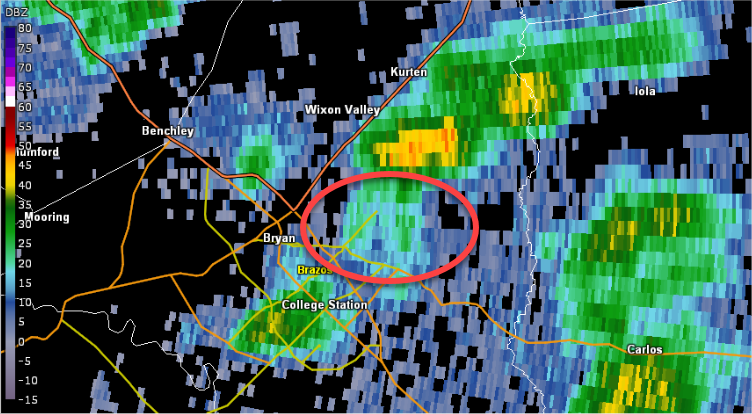
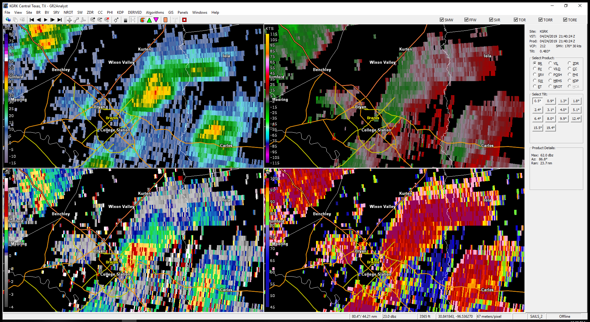
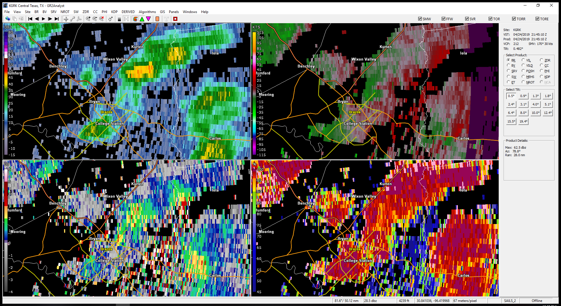
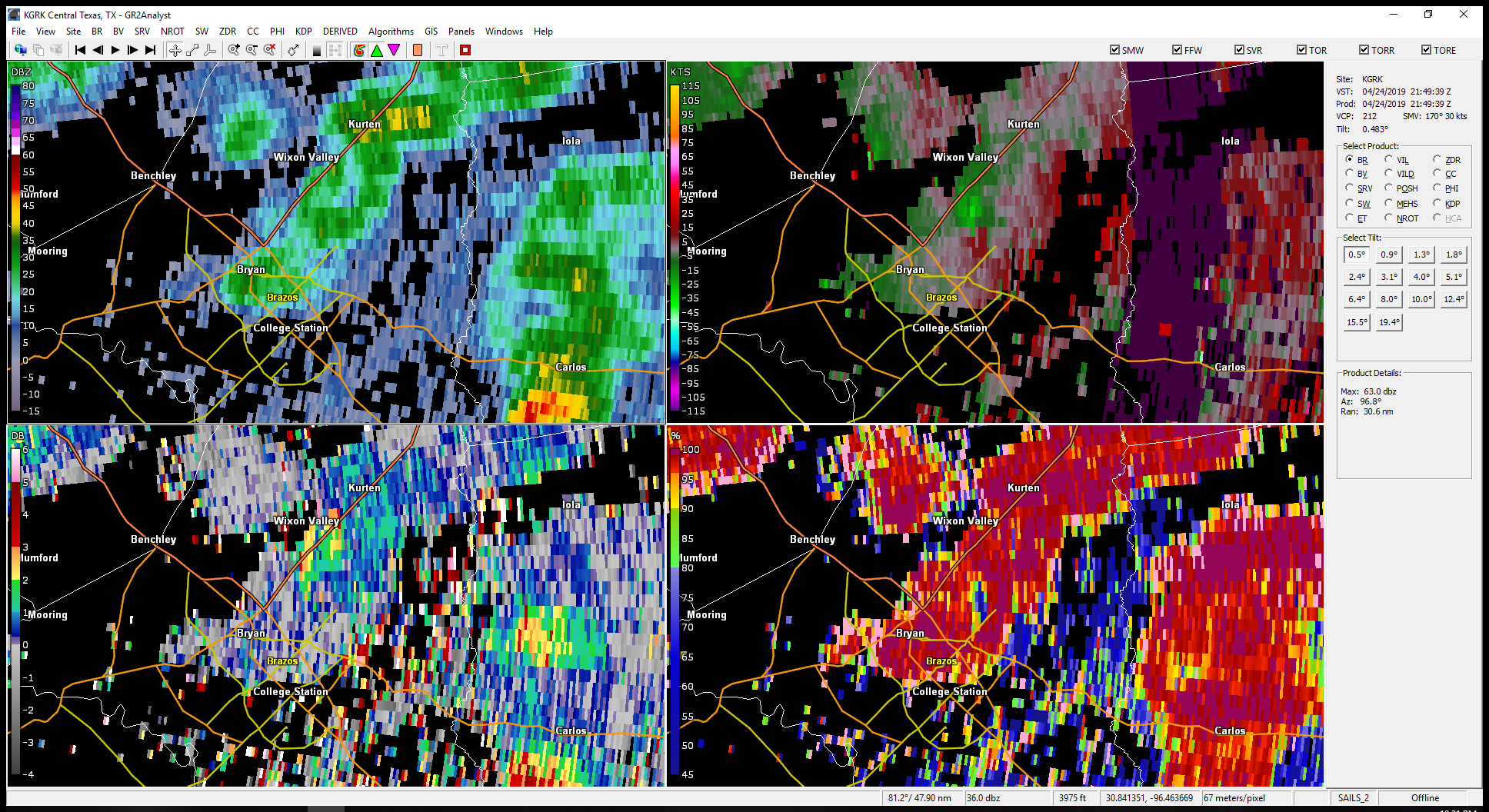
These four images show the evolution of the storm cells near Bryan from near the time the tornado touched down to shortly after it lifted.
4:40 PM: In the earliest image, you can see that there is a fairly strong rain shower east of Bryan in the upper left panel. However, the rotation seen in the upper right panel is located farther south than would be expected if this cell were indeed a mini-supercell. It is collocated with a small area of low reflectivity that may be part of this larger shower, though that fact is unclear at this time.
4:45 PM: In the upper left, one can see that the shower continues north towards Wixon Valley and Kurten. It has gained some separation from the area of lower reflectivity to its south, which is more clearly associated with the strongest rotation in the upper right panel. Looking at differential reflectivity (Zdr) in the lower left panel, there is a small area of Zdr that is 2-3 dB collocated with this area of lighter reflectivity, indicating that this is indeed a new updraft and a separate shower from the stronger cell to the north.
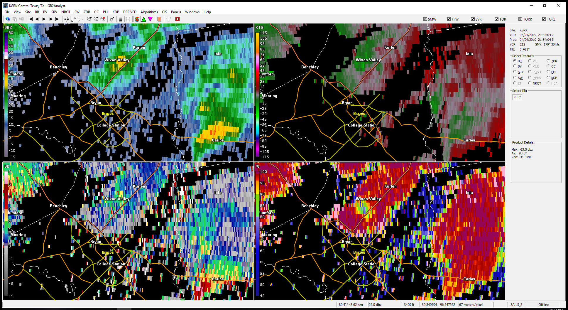
4:49 PM: The cell to the north is collapsing near Kurten, while the new cell east of Bryan continues to develop. The rotation is at its strongest here, as seen in the upper right panel. Looking at the correlation coefficient (CC) panel in the lower right, there is a patch of dramatically lower CC collocated with the rotation. CC this low is not associated with meteorological echoes, and is reminiscent of a tornado debris signature (TDS). This low CC patch occurs with an area of Zdr near zero, the strongest rotation, and the highest reflectivity (relatively speaking - this is still no more than 40 dBZ!). See below for a look at the vertical continuity of this feature.
4:54 PM: The shower is stronger as it reaches Wixon Valley, with widespread reflectivity above 40 dBZ. However, the storm relative velocity in the upper left shows that the rotation has weakened and become divergent, which typically occurs after a tornado has lifted. A low CC patch still exists with this cell, but the values of correlation coefficient are higher, and more spread out. This is also typical of what happens with a TDS after the tornado has dissipated, but before all the debris has fully settled out of the storm.
 |
 |
 |
 |
KGRK, 4:40 PM CDT
Click to Enlarge |
KGRK, 4:45 PM CDT
​Click to Enlarge |
KGRK, 4:49 PM CDT
​Click to Enlarge |
KGRK, 4:54 PM CDT
​Click to Enlarge |
Radar Cross-Section, 4:49 PM CDT
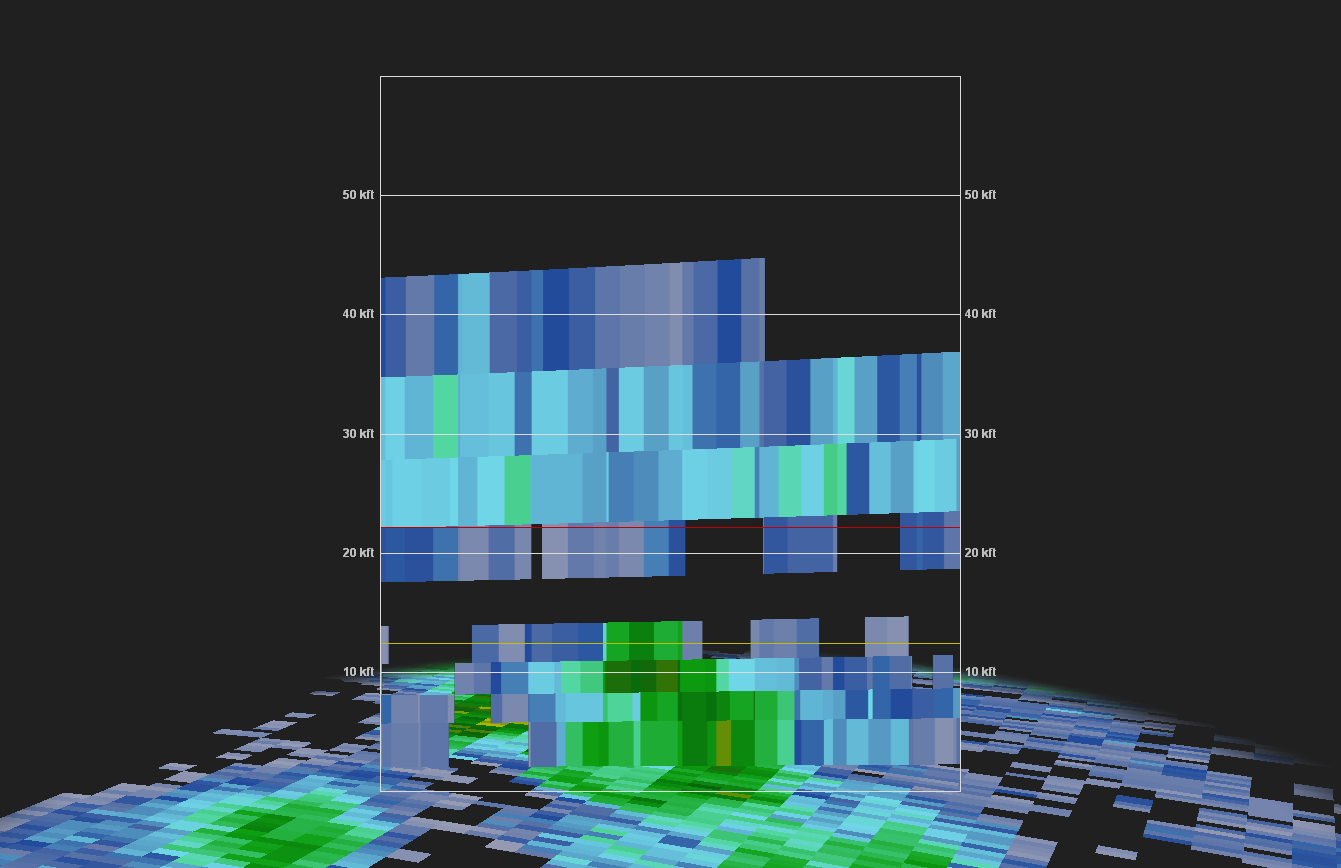
This set of images investigates the storm at 4:49 PM, when the rotation was strongest on radar and some features typical of a TDS were present. The leftmost image provides context for the cross-sections in the following images. It is a repeat of the four panel image at 4:49 above, with a white line showing where the following cross-sections are located. The northwestern point of the line is on the left of the cross-section, and the southeastern end is the rightmost edge of the cross-section. As a reminder, this time shows a patch of low CC and Zdr near zero, collocated with the strongest rotation and relatively high reflectivity.
Looking at the reflectivity cross-section, we can see that the shower is quite compact. The cell tops out roughly at the freezing level (yellow line) in the 12-13 thousand foot range. One can see some indication of organization in this compact storm, including an overhanging shelf of relatively higher reflectivity downshear of the main core. Taken in conjunction with the Zdr pattern noted above, it seems reasonable to consider this cell a new shower, separate from the stronger cell to its north. As an aside, the swath of returns centered at about 30,000 feet above ground is related to cirrus blowoff from the strong squall line to the west.
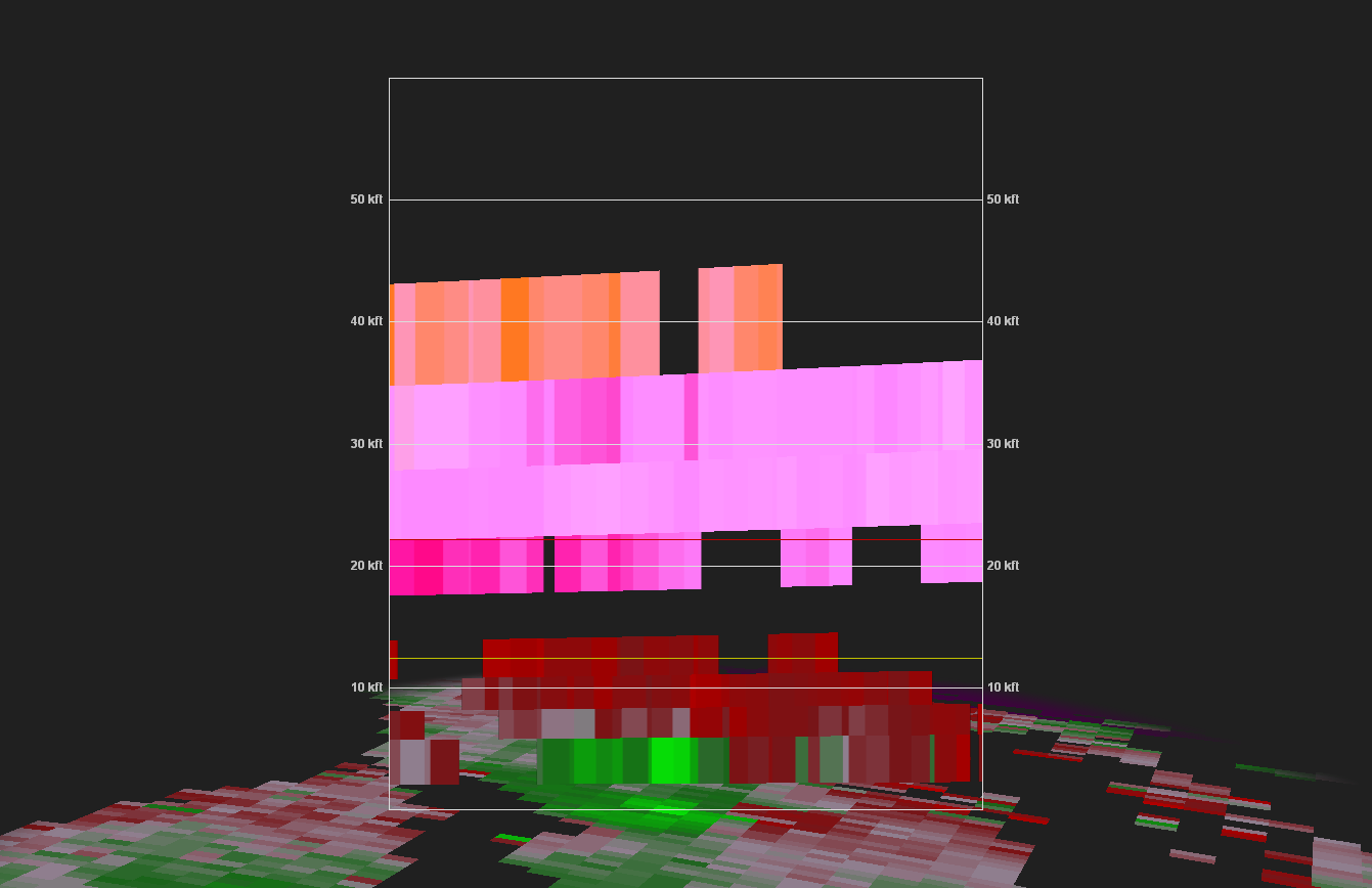
In the next cross-section, we see pretty clear rotation in the lowest elevation. It's not quite gate-to-gate, and looks to be very slightly divergent, so we have likely captured the state of the storm shortly after its strongest point and in a weakening phase. Regardless, the rotation is in a stronger state here than in the volume scans before or after, so is the closest we have to the storm at its peak strength. The rotation is clearly very compact, with only a faint hint of rotation in the elevation above it, and perhaps a ghost of rotation at best above that.
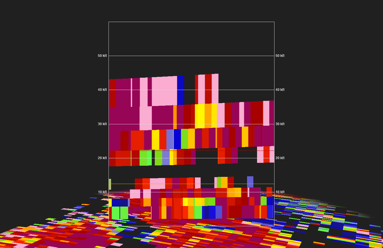
Finally, we investigate the correlation coefficient cross-section. The lowest CC, almost certainly associated with non-meteorological scatterers, is collocated with the strongest rotation and the highest reflectivity. Looking up an elevation, and there appears to be a similar, if less dramatic patch of lower CC. This appears to be the highest extent of any discernable debris signature. Still, at this range, we are seeing potential debris lofted to 7-8 thousand feet. This is lower than a "rule of thumb" of 10,000 feet for a TDS of an EF-2 or stronger tornado, but this rule is not hard and fast. This may be particularly true when a debris column to 8,000 feet is functionally raising debris through 80% of the storm's updraft.
 |
 |
 |
 |
KGRK 0.5° Four Panel
Click to Enlarge |
Reflectivity Cross-Section
Click to Enlarge |
Storm-Relative Velocity
Cross-Section
​Click to Enlarge |
Correlation Coefficient Cross-Section
​Click to Enlarge |