An upper level low lingering near the islands (water vapor satellite image) for days had made the atmosphere unstable, resulting in the development of heavy showers and thunderstorms around the islands. A small core of strong winds high in the atmosphere rotated around this upper level low during the day, helping to make the atmosphere near Oahu more unstable. During the late afternoon an area of showers being pushed west by the low level tradewind flow interacted with the Koolau Mountains on the windward (east) side of Oahu. As the air was pushed up over the mountains, the unstable environment allowed those showers to rapidly develop into a thunderstorm and remain focused over a small area of southeast Oahu (infrared satellite image). This thunderstorm, locked into place due to the terrain, produced very heavy rainfall totals in just a few hours (radar loop). The focus of the heaviest rain occurred over the southern portion of the Koolau Mountains on Oahu, resulting in Manoa Stream overflowing its banks and causing significant flooding in Manoa Valley, including the University of Hawaii campus.
At the height of the heavy rainfall (radar) around 7 pm, rainfall rates recorded at the gauge at the Manoa Lyon Arboretum, in the upper portion of Manoa Valley, were over 5 inches per hour. Here are some maximum rainfall accumulations at that site:
These large rainfall rates are estimated to occur with a return rate of almost 50 years. In other words, in any given year, there is only a 2% probability of such a heavy rainfall event like this occurring in upper Manoa Valley.
A stream gage operated by the US Geological Survey on Waiakeakua Stream, a tributary of Manoa Stream, detected a surge in flow between 6:45 pm and 7:40 pm in response to the peak rainfall.
Click for a map showing 24 hour rainfall totals across Oahu
Click for a map showing Doppler radar estimated rainfall
| Rainfall Totals (in inches) for selected locations across Southeast Oahu for the 12 hour period between 2pm October 30 and 2am October 31. | |
|---|---|
| Manoa Lyon Arboretum | 10.07 |
| Wilson Tunnel | 6.84 |
| Luluku | 6.47 |
| Saint Stephens | 4.68 |
| Alewa Heights | 4.45 |
| Maunawili | 3.41 |
| Ahuimanu Loop | 2.31 |
| Palolo | 2.12 |
| Moanalua | 1.69 |
| Olomana | 1.05 |
| Aloha Tower Downtown Honolulu | 0.34 |
| Honolulu Airport | 0.12 |
Significant damage occurred in Manoa Valley and on the University of Hawaii campus due to Manoa Stream overflowing its banks. The National Weather Service Office is located on the University of Hawaii campus, and although no damage occurred to the facility, two to three feet of water flowed through the parking lot and around the building in which the office is located, depositing mud and debris. Following are some pictures taken by staff members of damage on the University of Hawaii campus and elsewhere in Manoa Valley
Cars pushed by the floodwaters adjacent to Manoa Stream, Manoa Valley
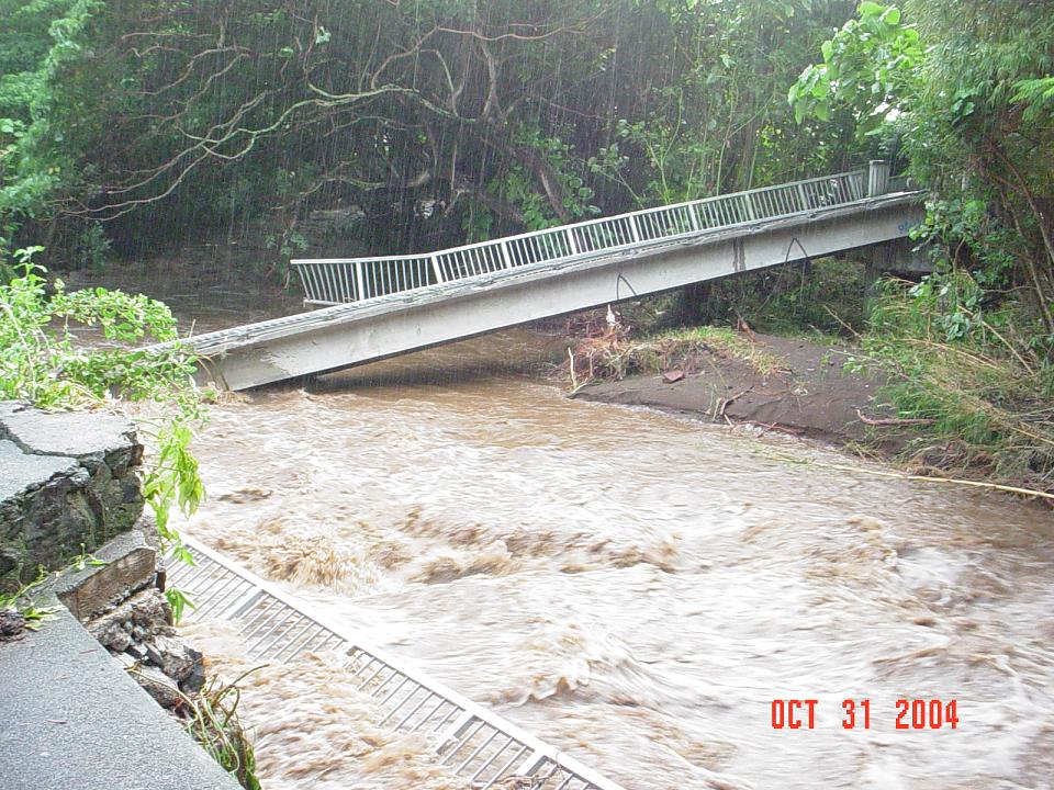
Small footbridge over Manoa Stream, Manoa Valley
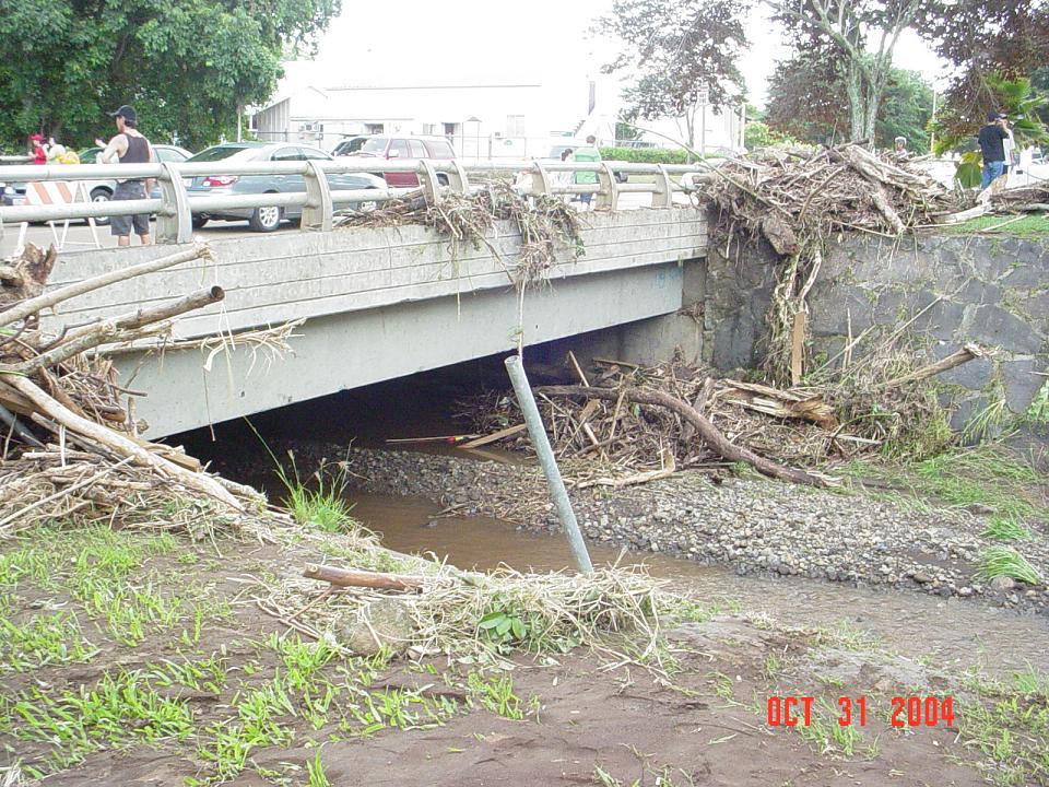
Debris on bridge over Manoa Stream, Manoa Valley
Vehicles parked by the Weather Service Office, University of Hawaii
Outside of Hamilton Library, University of Hawaii
Urban and Small Stream Flood Advisory - 355 pm
Flash Flood Warning - 631 pm (about 75 minutes before flooding began)
Short Term Forecast - 658 pm
Flash Flood Warning - 722 pm
Flash Flood Statement - 759 pm (includes first reports of flooding)
Flash Flood Statement - 837 pm (includes reports of flooding beginning on UH campus)
Short Term Forecast - 847 pm
Flash Flood Statement - 900 pm (reports of 2 feet of water by NWS office)
Flash Flood Statement - 1000 pm (canceling the warning)
Initial Storm Reports - 1112 pm

