Honolulu, HI
Weather Forecast Office
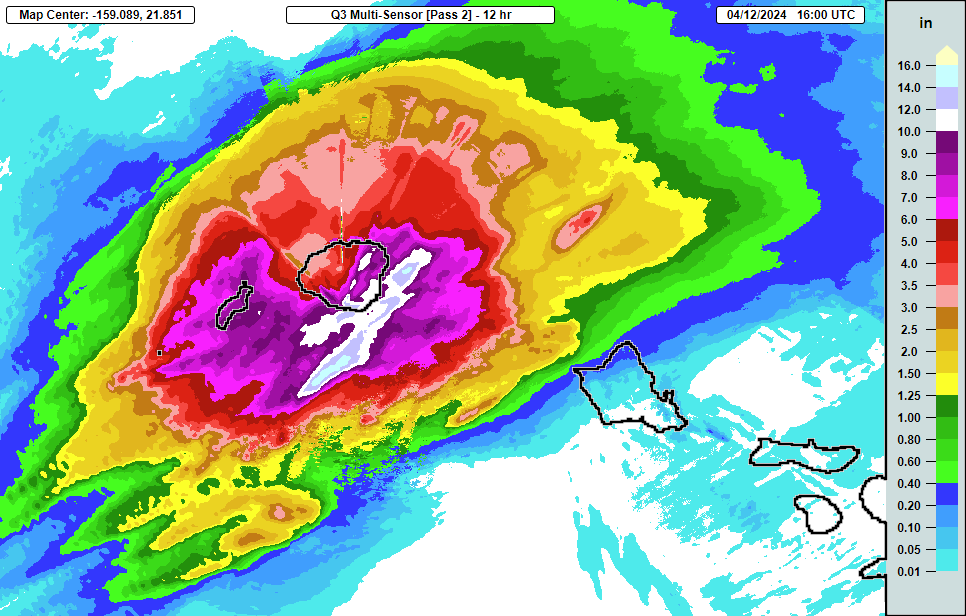
 A strong low pressure system northwest of the state brought a band of heavy rain and thunderstorms across Kauai. While light rain began during the day on Thursday, the most intense period of rain occurred in the 12 hour period between 6 pm Thursday and 6 am Friday. There were several evacuations in the Wailua and Koloa area and multiple roads were closed across the islands due to flooding and landslides.
The image on the right is from the Multi-Radar/Multi-Sensor (MRMS) quantitative precipitation estimates (QPE) for the 12 hour period ending at 6 am HST, Friday, April 12, 2024. The color scale is on the right, in inches of rainfall.
The following are automated rain gage totals for the 12 hour period ending at 6 am HST, April 12. All amounts are in inches. These totals are considered preliminary for information purposes only.
Location

Kauai                            12 hour total

KHEH1 Kalaheo (12008)                12.51
LIHH1 Lihue Var. Stn. (12006)        12.46
WLDH1 N Wailua Ditch (USGS)          12.05
LIH   Lihue Airport                  11.80
OMAH1 Omao (12004)                   11.35
WUHH1 Wailua (12005)                 11.26
POIH1 Poipu                          10.59
KPIH1 Kapahi (12003)                 10.00
WIRH1 Waiahi Rain Gage (USGS)         9.63
ANHH1 Anahola (12001)                 9.54
WLLH1 Mount Waialeale (USGS)          9.40
MLDH1 Moloaa Dairy                    8.91
PAKH1 Port Allen                      8.60
WMTH1 Waimea Tank (12007)             6.40
WHGH1 Waimea Heights                  5.91
PRIH1 Princeville Airport (12011)     5.77
HNIH1 Hanalei (12009)                 5.04
MCRH1 Mohihi Crossing (USGS)          4.50
POPH1 Puu Opae                        4.26
PLRH1 Puu Lua                         4.18
MNRH1 Mana                            4.12
WLGH1 Waialae (USGS)                  3.91
WKRH1 Waiakoali (USGS)                3.90
KLOH1 Kilohana (USGS)                 3.75
WNHH1 Wainiha (12010)                 3.48
MKAH1 Makaha Ridge                    3.19
US Dept of Commerce
National Oceanic and Atmospheric Administration
National Weather Service
Honolulu, HI
2525 Correa Rd Suite 250
Honolulu, HI 96822
(808) 973-5286
Comments? Questions? Please Contact Us.

