Overview
|
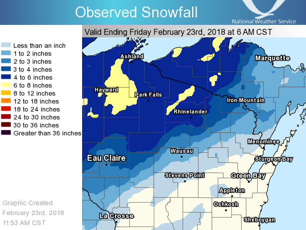
A low pressure system brought mixed precipitation to the region during the overnight hours of Thursday (February 22, 2018) and early Friday (February 23, 2018) morning. Mainly snow fell across north-central Wisconsin where temperatures stayed below freezing with snowfall amounts of 3 to 6 inches. A mix of snow, sleet and freezing rain across central and northeast Wisconsin where temperatures started out below freezing and slowly warmed to near freezing as the morning wore on with snowfall amounts of 1 to 2 inches. Finally across east-central Wisconsin mainly freezing rain and rain fell where temperatures started out close to freezing and warmed to above freezing during Friday morning with little to no snowfall accumulation. Despite no snowfall accumulation, a light glaze of ice was noted across much of east-central Wisconsin on Friday morning. The impact from this storm was snow covered roadways across north-central Wisconsin with ice covered roadways across east-central Wisconsin. During the early morning hours of Friday the icing caused a passenger plane to skid off the runway at the Austin Staubel International Airport in Green Bay, WI (KGRB). See the tabs below for more information. |
Snowfall Reports
PUBLIC INFORMATION STATEMENT NATIONAL WEATHER SERVICE GREEN BAY WI 944 AM CST FRI FEB 23 2018 ...24-Hour Snowfall Reports... Location Amount Time/Date Lat/Lon ...Wisconsin... ...Florence County... Spread Eagle 3.5 in 0730 AM 02/23 45.88N/88.13W Aurora 4 W 3.0 in 0700 AM 02/23 45.79N/88.18W 1 NW Spread Eagle 2.0 in 0640 AM 02/23 45.89N/88.14W Spread Eagle 1 NW 2.0 in 0700 AM 02/23 45.89N/88.14W ...Forest County... Argonne 1.5 NW 4.1 in 0714 AM 02/23 45.67N/88.90W Crandon 3.5 in 0600 AM 02/23 45.55N/88.90W ...Langlade County... Summit Lake 3.5 in 0700 AM 02/23 45.38N/89.19W Antigo 1 SSW 1.0 in 0800 AM 02/23 45.13N/89.15W ...Lincoln County... Rice Reservoir No. 2 4.4 in 0600 AM 02/23 45.54N/89.73W Merrill 8 W 2.0 in 0600 AM 02/23 45.18N/89.85W Merrill 7 W 2.0 in 0600 AM 02/23 45.18N/89.85W ...Marathon County... Wausau-Northeast 1.7 in 0650 AM 02/23 44.97N/89.62W Wausau 1.6 in 0715 AM 02/23 44.96N/89.63W Spencer - Wwtp 1.4 in 0730 AM 02/23 44.75N/90.29W Wausau 1 ENE 1.2 in 0700 AM 02/23 44.97N/89.61W ...Marinette County... Crivitz High Falls 1.0 in 0800 AM 02/23 45.36N/88.19W Athelstane 1.0 in 0600 AM 02/23 45.42N/88.06W Wausaukee 1.0 in 0800 AM 02/23 45.38N/87.96W ...Oneida County... 2 SE Hazelhurst 6.1 in 0750 AM 02/23 45.77N/89.68W Minocqua 6.0 in 0630 AM 02/23 45.89N/89.73W Rhinelander 3 WNW 6.0 in 0700 AM 02/23 45.66N/89.46W Lake Tomahawk 2 SE 4.8 in 0600 AM 02/23 45.81N/89.56W Bradley 2 NNW 4.2 in 0700 AM 02/23 45.56N/89.77W Rhinelander 4.2 in 0724 AM 02/23 45.63N/89.41W Lake Tomahawk 2.0 in 0221 AM 02/23 45.81N/89.59W Rhinelander WJFW TV 1.2 in 1030 PM 02/22 45.62N/89.41W ...Vilas County... Boulder Junction 9 ENE 6.3 in 0710 AM 02/23 46.19N/89.46W Arbor Vitae-Johnson Lake 5.7 in 0605 AM 02/23 45.90N/89.73W Land O Lakes 3 W 5.6 in 0700 AM 02/23 46.17N/89.30W St Germain 5.5 in 0600 AM 02/23 45.92N/89.49W Eagle River 4 E 5.1 in 0641 AM 02/23 45.92N/89.15W Eagle River - South 5.0 in 0659 AM 02/23 45.91N/89.24W Phelps 5.0 in 0700 AM 02/23 46.07N/89.08W Lac Vieux Desert 4.5 in 0753 AM 02/23 46.12N/89.08W ...Wood County... Marshfield Exp Farm 1.0 in 0730 AM 02/23 44.64N/90.13W Observations are collected from a variety of sources with varying equipment and exposures. We thank all volunteer weather observers for their dedication. Not all data listed are considered official. |
 |
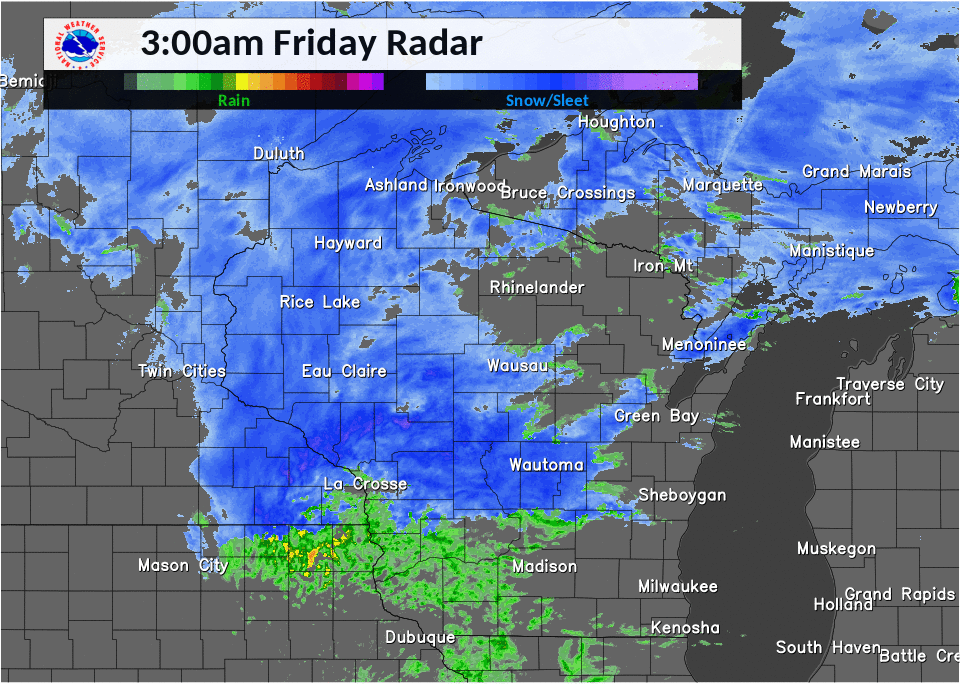
Radar:
Here is a look at the radar loop from 3 am through 8 am Friday, February 23, 2018.
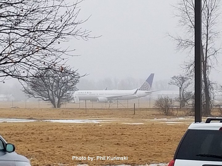
Picture of Plane:
Here is a picture of the plane that slid off the runway at the Austin Straubel International Airport in Green Bay, WI (KGRB) during the early morning hours of Friday February 23, 2018.
 |
Media use of NWS Web News Stories is encouraged! Please acknowledge the NWS as the source of any news information accessed from this site. |
|

