Overview
|
Multiple rounds of thunderstorms impacted central and northern Wisconsin from early in the morning into the evening hours of April 28, 2025. Stronger storms during the daytime produced hail ranging from pea to quarter size. |
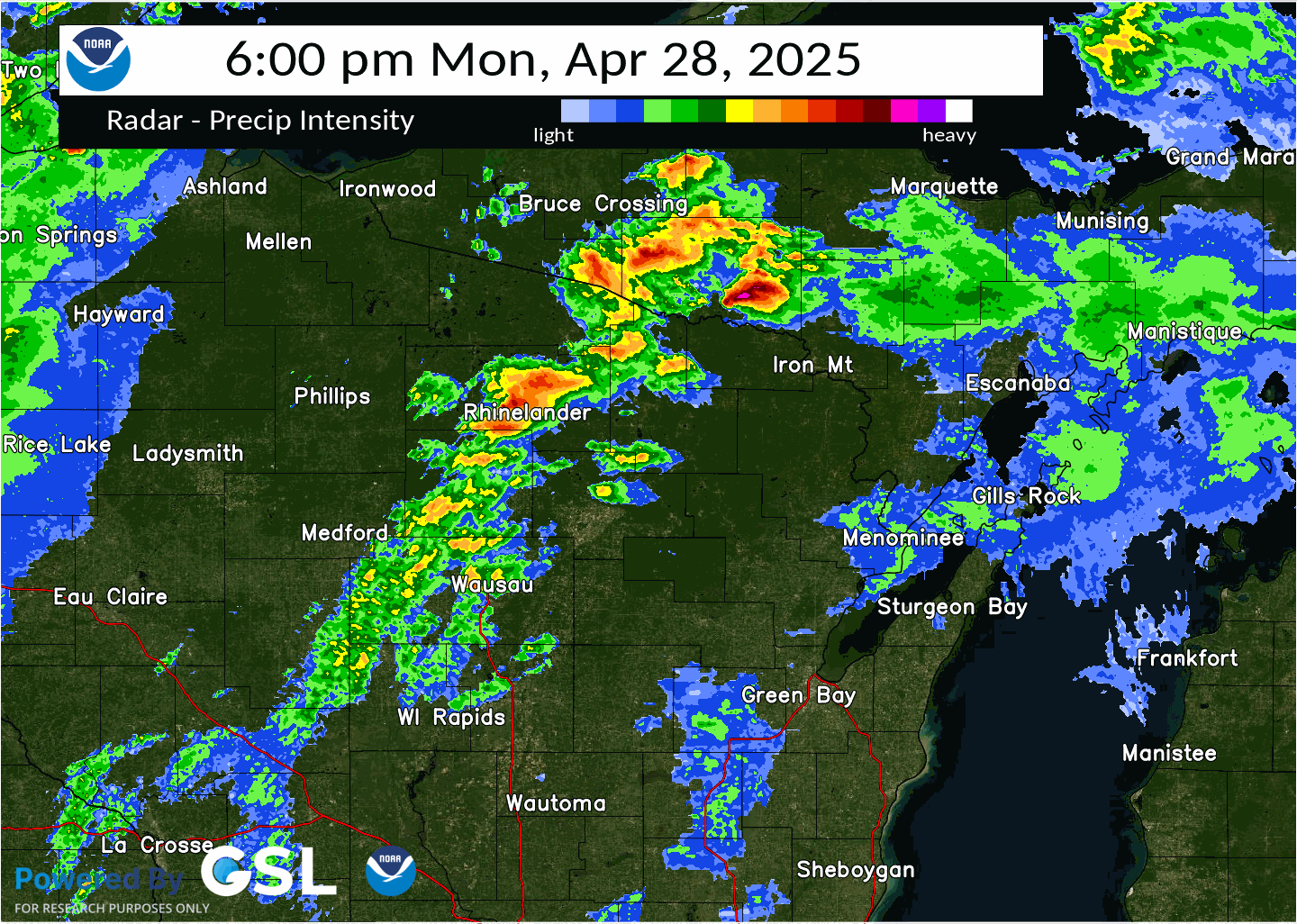 Radar loop from 6 PM Apr 28 to 1 AM Apr 29 |
Tornadoes
Select a tornado from the table to zoom into the track and view more information. The default table view is limited to 8 tracks, but can be scrolled by a mouse wheel or dynamically expanded. Additionally, the table can fill the entire window by clicking the small circular expanding arrow icon at the very top right of the table and returned to its original size by clicking the button again. The side information panel that opens over the map can be closed using the "X" on the upper right corner of the pop-up. Zoom into the map and click damage points to see detailed information and pictures from the surveys.
|
NOTE: times shown below are local to your device's time zone. |

The Enhanced Fujita (EF) Scale classifies tornadoes into the following categories:
| EF0 Weak 65-85 mph |
EF1 Moderate 86-110 mph |
EF2 Significant 111-135 mph |
EF3 Severe 136-165 mph |
EF4 Extreme 166-200 mph |
EF5 Catastrophic 200+ mph |
 |
|||||
| Tornadoes that fail to impact any ratable structures on the EF-Scale are rated EF-Unknown (EF-U) | |||||
Storm Reports
.png)
..TIME...   ...EVENT...      ...CITY LOCATION...     ...LAT.LON...
..DATE...   ....MAG....      ..COUNTY LOCATION..ST.. ...SOURCE....
            ..REMARKS..

0730 AM     Hail             1 SSE Zittau            44.20N 88.77W
04/28/2025  M0.88 Inch       Winnebago          WI   Trained Spotter

            6 SE Fremont. Hail covering the ground.

0802 AM     Hail             3 NW Neenah             44.22N 88.49W
04/28/2025  E0.75 Inch       Winnebago          WI   Public

            Report from mPING: Dime (0.75 in.).

1053 AM     Hail             1 ENE Crivitz           45.24N 87.99W
04/28/2025  M0.75 Inch       Marinette          WI   Public


0209 PM     Hail             1 S Marshfield          44.65N 90.16W
04/28/2025  M0.50 Inch       Wood               WI   Trained Spotter


0233 PM     Hail             2 NW Wausau             44.98N 89.66W
04/28/2025  M0.50 Inch       Marathon           WI   Public


0233 PM     Hail             2 N Wausau              44.99N 89.63W
04/28/2025  M0.75 Inch       Marathon           WI   Public


0335 PM     Hail             Merrill                 45.18N 89.68W
04/28/2025  M0.25 Inch       Lincoln            WI   Public


0336 PM     Hail             2 W Merrill             45.19N 89.71W
04/28/2025  E1.00 Inch       Lincoln            WI   Public

            Report from mPING: Quarter (1.00 in.).

0418 PM     Hail             3 SW Vesper             44.45N 90.00W
04/28/2025  E0.50 Inch       Wood               WI   Public

            Report from mPING: Half-inch (0.50 in.).

0700 PM     Hail             2 E Sunset              44.97N 89.45W
04/28/2025  M0.50 Inch       Marathon           WI   Public


0744 PM     Hail             1 NE Mountain           45.19N 88.47W
04/28/2025  M0.50 Inch       Oconto             WI   Trained Spotter


0921 PM     Tstm Wnd Gst     Rhinelander Airport     45.63N 89.48W
04/28/2025  M55 MPH          Oneida             WI   ASOS

            .

0924 PM     Tstm Wnd Gst     6 NE Halder             44.86N 89.79W
04/28/2025  M67 MPH          Marathon           WI   Trained Spotter

            Delayed report. Reported by mobile trained
            weather spotter with measuring equipment
            northwest of Mosinee. Confirmed by Marathon
            County Emergency Manager.

0925 PM     Tstm Wnd Dmg     4 SE Rothschild         44.84N 89.55W
04/28/2025                   Marathon           WI   Public

            Tree caught fire and fell on power line.

0937 PM     Tstm Wnd Gst     Wausau Downtown Airport 44.93N 89.63W
04/28/2025  M51 MPH          Marathon           WI   Public


0954 PM     Tstm Wnd Gst     2 NE Port Edwards       44.36N 89.84W
04/28/2025  M46 MPH          Wood               WI   ASOS

            At Wisconsin Rapids airport. Outflow wind
            gust.

1000 PM     Tstm Wnd Dmg     2 ENE Eland             44.89N 89.16W
04/28/2025                   Shawano            WI   Public

            Trees snapped and uprooted. The time of this
            report is an estimate based on radar.

1002 PM     Tornado          3 E Birnamwood          44.93N 89.12W
04/28/2025                   Shawano            WI   NWS Storm Survey

            .

1004 PM     Tornado          Mattoon                 45.00N 89.03W
04/28/2025                   Shawano            WI   NWS Storm Survey


1004 PM     Tstm Wnd Dmg     1 S Mattoon             44.99N 89.03W
04/28/2025                   Shawano            WI   NWS Storm Survey

            Trees and power poles down.

1009 PM     Hail             Antigo                  45.15N 89.14W
04/28/2025  E0.75 Inch       Langlade           WI   Public

            Report from mPING: Dime (0.75 in.).

1051 PM     Tstm Wnd Dmg     5 NNW Klondike          45.12N 88.21W
04/28/2025                   Oconto             WI   Public

            Social media post of thunderstorm wind
            damage to barn.

1130 PM     Tstm Wnd Gst     2 SE Menominee          45.10N 87.59W
04/28/2025  M61 MPH          Marinette          WI   Buoy

            Buoy station MNMM4 Menominee.

1140 PM     Tstm Wnd Gst     1 NNW Chambers Island   45.20N 87.36W
04/28/2025  M44 MPH          Door               WI   Mesonet

            Mesonet station CBRW3 Chambers Island 1 NNW.

1141 PM     Tstm Wnd Gst     3 ESE Oneida            44.48N 88.13W
04/28/2025  M45 MPH          Brown              WI   ASOS

            ASOS station KGRB Green Bay Airport.
Environment/Additional
Radar: (Highlighting the time period/location of the Mattoon tornado.)
 |
 |
 |
| (Left) Reflectivity and (Right) Storm Relative Velocity around 10:01 PM | (Left) Reflectivity and (Right) Storm Relative Velocity around 10:05 PM | (Left) Reflectivity and (Right) Storm Relative Velocity around 10:08 PM |
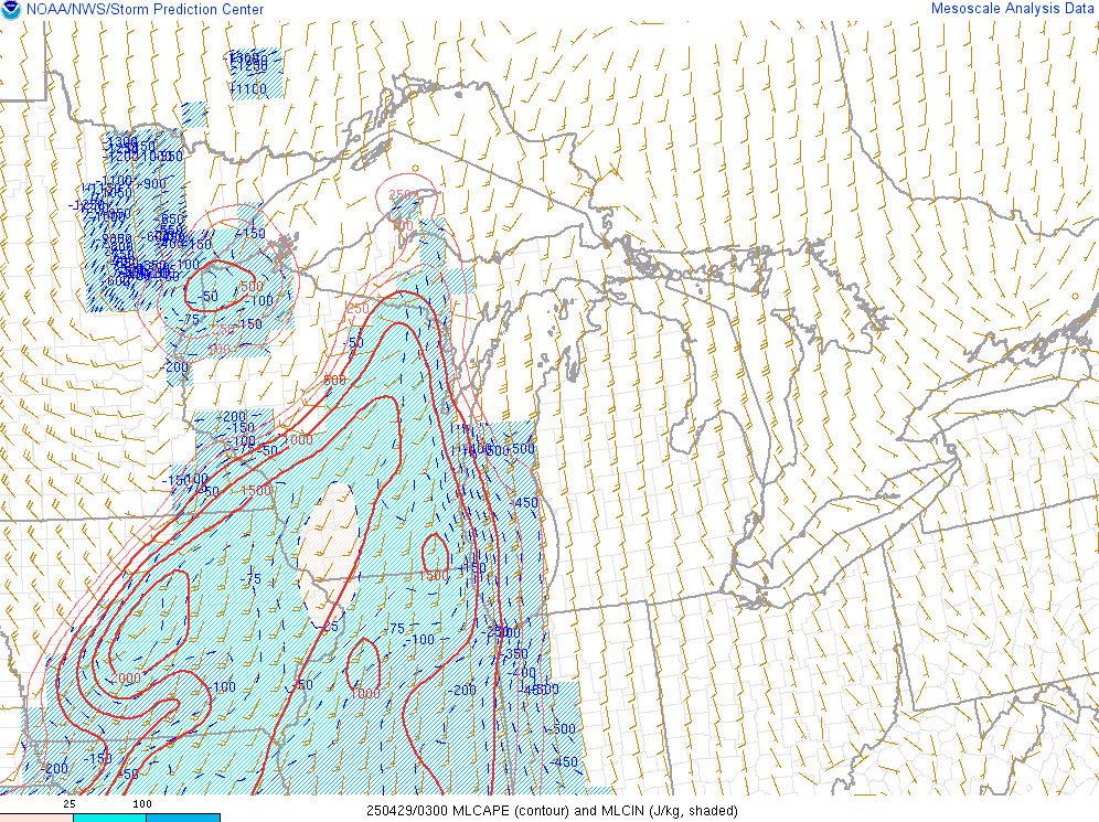
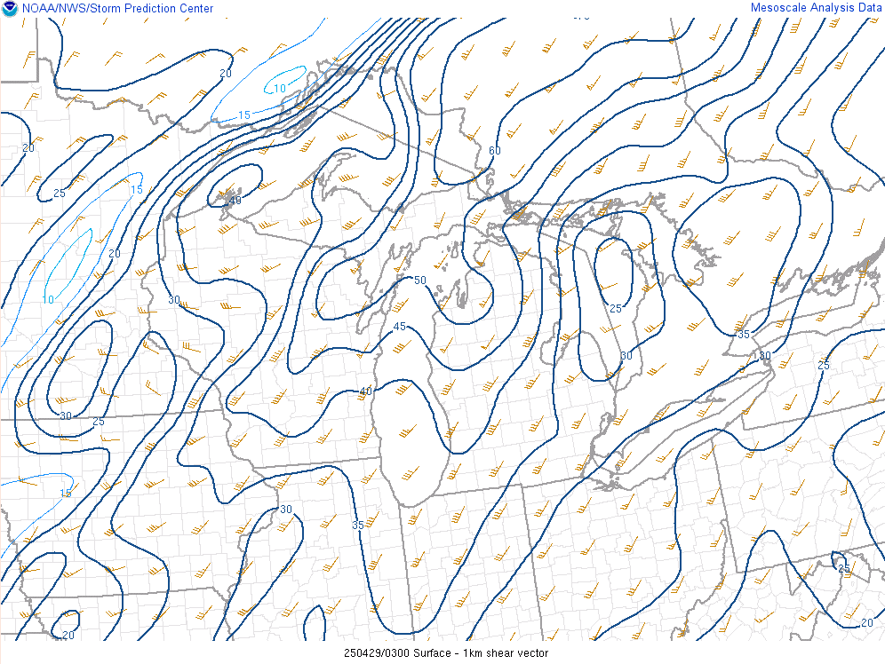
Near-Storm Environment:
 |
 |
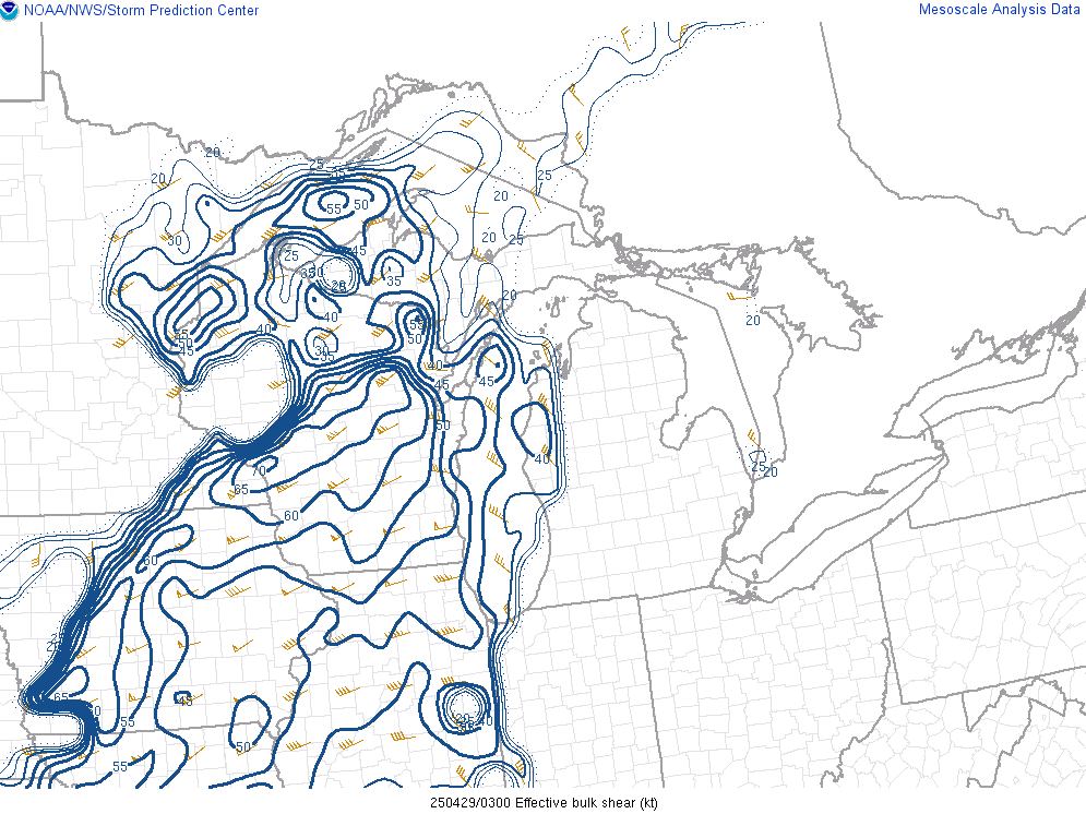 |
| Mixed-Layer CAPE (instability) at 10 PM | 0-1 km Shear at 10 PM | Effective Bulk Shear at 10 PM |
Watches and Warnings
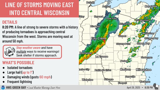 |
.jpg) |
 |
| Graphic highlighting approaching storms | Tornado Warning | Tornado Watch |
Photos
 |
 |
 |
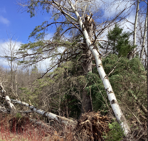 |
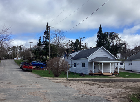
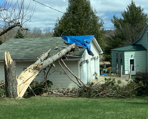
| Damage near Mattoon, WI (NWS Damage Survey) |
Damage near Mattoon, WI (NWS Damage Survey) |
Damage near Mattoon, WI (NWS Damage Survey) |
Damage near Mattoon, WI (NWS Damage Survey) |
 |
Media use of NWS Web News Stories is encouraged! Please acknowledge the NWS as the source of any news information accessed from this site. |
|

