Overview
|
Waves of low pressure brought several periods of mixed precipitation to north-central and northeast Monday (February 19, 2018) into Tuesday morning (February 20, 2018). On Monday, arctic air moved into northern Wisconsin where temperatures fell into the teens and 20s north and west of the Fox Valley. Meanwhile, spring like warmth was flowing north towards Wisconsin where Chicago warmed to 60 degrees. Warm air flowing north over the cold air mass near the ground brought a mix of freezing rain, sleet, and snow Monday into Monday evening to areas north and west of the Fox Valley. This wintry mix changed over to light freezing rain or freezing drizzle Monday night into Tuesday morning. Temperatures from Wautoma to the Fox Valley, east to Kewaunee and Manitowoc, were well above freezing through early afternoon on Monday. The arctic front then surged south across east-central Wisconsin late in the afternoon. Temperatures in this region fell 5 to 10 degrees in a few hours, resulting in the rain changing to freezing rain and freezing drizzle (with some sleet at times). Untreated roads, bridges, and sidewalks quickly became ice covered and slippery around sunset. Another round of heavier freezing rain moved across the entire area early Tuesday morning. Snowfall amounts of 1 to 3 inches were noted across far north-central Wisconsin. Most of central and northeast Wisconsin saw a tenth to a quarter inch of ice. The exception was near Lake Michigan in Manitowoc County where little or no icing was noted. Despite the icy conditions, there were just a few reports of tree damage or power outages. See the tabs below for more information. |
Ice / Snowfall Reports
Radar:
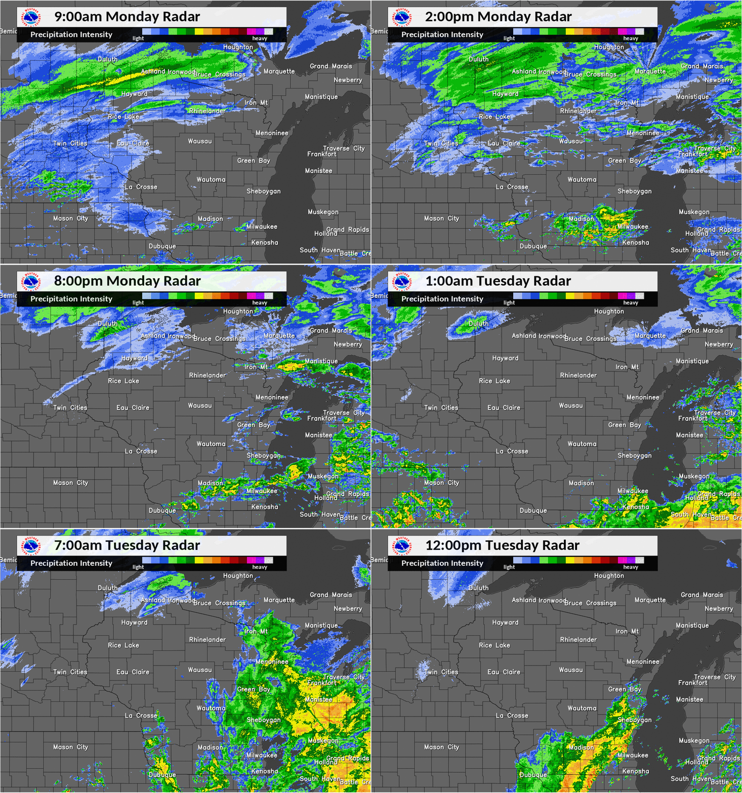
Here is a look at the radar loop from 9am Monday, February 19 through 12pm Tuesday, February 20. Note: the radar overshoots some of the snow and freezing drizzle across portions of Wisconsin.

Wind Reports:
...Peak Wind Reports Past 24 Hours...

Location                     Speed     Time/Date       Lat/Lon

Green Bay Airport            44 MPH    0258 PM 02/19   44.50N/88.11W
Port Edwards 2 WNW           44 MPH    0549 PM 02/19   44.35N/89.88W
Plover 1 WSW                 32 MPH    0321 PM 02/19   44.44N/89.55W
Appleton Airport             31 MPH    0245 PM 02/19   44.26N/88.52W
Kewaunee                     30 MPH    0112 PM 02/19   44.47N/87.50W
Combined Locks 1 W           30 MPH    0240 PM 02/19   44.24N/88.34W
Coloma 4 W                   28 MPH    0428 PM 02/19   44.02N/89.60W
Manitowoc Airport            28 MPH    1244 PM 02/19   44.13N/87.68W
Wisconsin Rapids Airport     28 MPH    0254 PM 02/19   44.36N/89.84W
Marshfield Airport           28 MPH    0254 PM 02/19   44.64N/90.19W
Pittsville                   26 MPH    0322 PM 02/19   44.45N/90.13W
Stevens Point Airport        26 MPH    0535 PM 02/19   44.55N/89.53W
Oshkosh Airport              26 MPH    0153 PM 02/19   43.98N/88.56W
Wautoma Airport              26 MPH    0456 PM 02/19   44.04N/89.30W
Rhinelander Airport          25 MPH    0353 PM 02/19   45.63N/89.47W
Howard 2 WNW                 25 MPH    0113 PM 02/19   44.58N/88.09W
Washington Island 1 WNW      25 MPH    0135 PM 02/19   45.39N/86.92W


Observations are collected from a variety of sources with varying
equipment and exposures. We thank all volunteer weather observers
for their dedication. Not all data listed are considered official.
 |
Media use of NWS Web News Stories is encouraged! Please acknowledge the NWS as the source of any news information accessed from this site. |
 |