
Persistent arctic air is forecast to break numerous daily records and produce dangerously cold sub-zero wind chills across the Central and Southern Plains, Lower Mississippi Valley, and the Southeast U.S. today. An atmospheric river will bring heavy rain and mountain snow to the Pacific Northwest states and northern Rockies today through at least Tuesday. Read More >
Macroburst and EF-1 Tornado Confirmed in Plentywood, MT on July 9, 2018
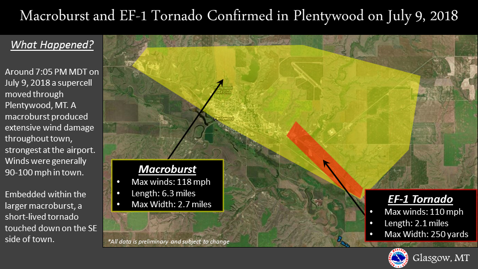
Information on the Macroburst

...PRELIMINARY DAMAGE SURVEY RESULTS FOR PLENTYWOOD, MT...

 THE STORM SURVEY INVESTIGATION IS STILL ONGOING AND SUBJECT TO
 FURTHER COORDINATION WITH LOCAL EMERGENCY MANAGEMENT AGENCIES.

 ...A supercell moved southeast through Plentywood, MT on the
 evening of July 9, 2018 producing widespread significant wind
 damage....

 THE FOLLOWING IS A PRELIMINARY ASSESSMENT FOR THE DAMAGE THAT
 OCCURRED OVER PLENTYWOOD, MT ON JULY 9, 2018.

 * EVENT DATE: JULY 9, 2018

 * ESTIMATED START TIME: 7:05 PM MDT

 * EVENT TYPE: Macroburst

 * EVENT LOCATION: Plentywood, MT

 * PEAK WIND: 110 - 118 MPH

 * PATH WIDTH: 2.7 miles

 * PATH LENGTH: 6.2 miles

 * INJURIES: 0

 * FATALITIES: 0

 * DISCUSSION/DAMAGE: A right moving supercell moved through
 Plentywood, MT around 7 PM MDT producing widespread significant
 wind damage. The Plentywood airport saw 10 small general aviation
 planes significantly damaged or destroyed. There were also 8
 hangars totaled with 6 others receiving minor to moderate damage.
 The metal beacon tower at the airport was bent over to the ground.
 This is where the strongest winds were found, estimated at up to
 118 mph. As the supercell progressed southeast, widespread tree
 and roof damage was found throughout Plentywood, with several
 outbuildings/garages being destroyed. Wind speeds throughout the
 town were generally 90-100 mph.
Information on the EF-1 Tornado
...PRELIMINARY DAMAGE SURVEY RESULTS FOR PLENTYWOOD, MT...

 THE STORM SURVEY INVESTIGATION IS STILL ONGOING AND SUBJECT TO
 FURTHER COORDINATION WITH LOCAL EMERGENCY MANAGEMENT AGENCIES

 ...A supercell moved southeast through Plentywood, MT on the
 evening of July 9, 2018 producing a brief tornado on the
 southeast side of town...

 THE FOLLOWING IS A PRELIMINARY ASSESSMENT FOR THE DAMAGE THAT
 OCCURRED OVER PLENTYWOOD, MT ON JULY 9, 2018.

 * EVENT DATE: JULY 9, 2018

 * ESTIMATED START TIME: 7:06 PM MDT

 * EVENT TYPE: EF-1 TORNADO

 * EVENT LOCATION: Southeast side of Plentywood, MT

 * PEAK WIND: 110 MPH

 * PATH WIDTH: 250 Yards

 * PATH LENGTH: 2.1 Miles

 * INJURIES: 0

 * FATALITIES: 0

 * DISCUSSION/DAMAGE: Embedded within a Macroburst, a brief tornado
 touched down on the southeast side of Plentywood, MT on the evening
 of July 9, 2018. A mobile home was completely destroyed
 and two small farm outbuildings were heavily damaged with evidence
 of splattering of the insolation on the south and east side of the
 buildings (the storm moved from northwest to southeast). An adjacent
 1-story business sustained roof damage with several 2x4`s pierced
 through the roof (coming from a south to north direction). A
 vehicle had 4 separate 2x4`s pierce through the windows and the body
 of the vehicle. Multiple empty trailers were flipped over and a
 restaurant had the front doors and several windows blown out and
 part of the roof torn off on the southeast side of the building.
 Several vehicles had windows blown out and two empty grain bins
 were thrown several hundred yards.

 This is the second of two reports on this storm.

 &&

 FOR REFERENCE...THE ENHANCED FUJITA TORNADO SCALE CLASSIFIES
 TORNADOES INTO THE FOLLOWING CATEGORIES:

 EF0...WIND SPEEDS 65 TO 85 MPH.
 EF1...WIND SPEEDS 86 TO 110 MPH.
 EF2...WIND SPEEDS 111 TO 135 MPH.
 EF3...WIND SPEEDS 136 TO 165 MPH.
 EF4...WIND SPEEDS 166 TO 200 MPH.
 EF5...WIND SPEEDS GREATER THAN 200 MPH.

