
Thunderstorms, some severe, may produce heavy to excessive rainfall and isolated flooding over portions of the Southern Plains today and Saturday. Dry conditions, combined with gusty winds and low relative humidities will continue to support an elevated to critical fire weather threat in the Desert Southwest into to early next week. Read More >
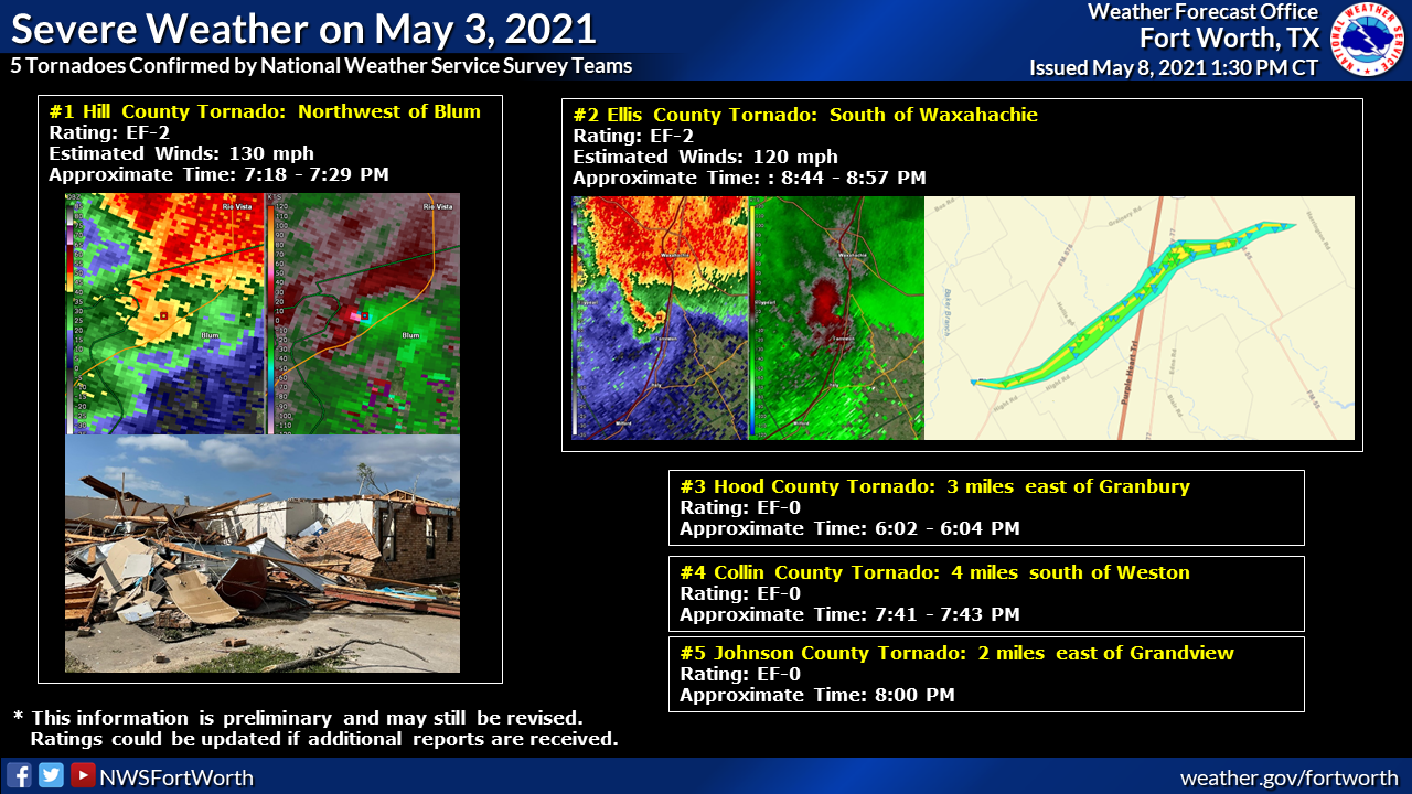
000
NOUS44 KFWD 050103
PNSFWD
TXZ091>095-100>107-115>123-129>135-141>148-156>162-174-175-051315-

Public Information Statement
National Weather Service Fort Worth TX
803 PM CDT Tue May 4 2021

...NWS Damage Survey for 5/3/21 Tornadoes...

.Overview...
Multiple supercell thunderstorms developed ahead of a cold front
and dryline during the late afternoon and evening hours of May 3rd
2021. These storms produced a total of 5 tornadoes, consisting
of 2 EF-2s and 3 EF-0s.


.Hill County Tornado Near Blum...

Rating:                 EF2
Estimated Peak Wind:    130 mph
Path Length /statute/:  3.359 miles
Path Width /maximum/:   150.0 yards
Fatalities:             0
Injuries:               0

Start Date:             05/03/2021
Start Time:             07:18 PM CDT
Start Location:         3 W Blum / Hill County / TX
Start Lat/Lon:          32.1426 / -97.4449

End Date:               05/03/2021
End Time:               07:29 PM CDT
End Location:           4 NW Blum / Hill County / TX
End Lat/Lon:            32.1876 / -97.4425

Survey Summary:
The tornado formed in extreme northern Hill County, Texas, NW of
the Blum community, near the intersection of Texas Highway 174 and
Hill County Road 1106. The tornado traveled across open country
for approximately 3.4 miles. Scattered tree and powerline damage
of EF-0 intensity was noted along the length of this path. Near
the end of the tornado`s lifespan, it struck a brick-clad frame
home, removing most of the roof and part of the walls of the
structure. The tornado`s peak intensity of EF-2, with estimated
wind speeds of 130 mph, was inferred from the damage to this
structure. Some other trees and outbuildings sustained EF-0 to
EF-1 damage near this home. The tornado dissipated several
hundred yards beyond the point where the tornado impacted the
frame home.


..Ellis County Tornado South of Waxahachie...

Rating:                 EF2
Estimated Peak Wind:    120 mph
Path Length /statute/:  5.2289 miles
Path Width /maximum/:   659.0 yards
Fatalities:             0
Injuries:               8

Start Date:             05/03/2021
Start Time:             08:44 PM CDT
Start Location:         6 ESE Maypearl / Ellis County / TX
Start Lat/Lon:          32.2844 / -96.9059

End Date:               05/03/2021
End Time:               08:57 PM CDT
End Location:           6 SSE Waxahachie / Ellis County / TX
End Lat/Lon:            32.3168 / -96.8295

Survey Summary:
Damage started in the Five Points area along FM 876. The tornado
continued northeast and the first signs of EF-2 damage were
observed near Johnston and Hollis Roads. The tornado then crossed
I-35E where it struck 3 semis and one cargo van. Three injuries
occurred in this location. Next, the tornado struck a scrap metal
yard on the east side of I-35E and moved on to damage homes and
electrical towers near and along HWY 77 and Butler Ln. EF-2
damage was also observed in this area, in particular to one home.
Maximum estimated winds were 120 mph, and there were 5 additional
injuries in this area. The tornado tracked farther east, did EF-2
damage to one home on FM 55, and then crossed FM 55 and
dissipated.


..Hood County Tornado Near Granbury...

Rating:                 EF0
Estimated Peak Wind:    65 mph
Path Length /statute/:  0.3598 miles
Path Width /maximum/:   50.0 yards
Fatalities:             0
Injuries:               0

Start Date:             05/03/2021
Start Time:             06:02 PM CDT
Start Location:         3 E Granbury / Hood County / TX
Start Lat/Lon:          32.4403 / -97.7406

End Date:               05/03/2021
End Time:               06:04 PM CDT
End Location:           2 E Granbury / Hood County / TX
End Lat/Lon:            32.445 / -97.7434

Survey Summary:
A tornado formed along Davis Road in east Granbury and traveled
slowly north-northwest. Spotter videos show the tornado was
occurring for approximately 2 minutes with debris consisting
mainly of leaves and small branches being lofted into the air.
Damage to a car port and some mature trees occurred along the
path. The tornado dissipated as it approached Highway 377.
Maximum winds were estimated at 65 mph with a width of 50 yards.


.Collin County Tornado Near Weston...

Rating:                 EF0
Estimated Peak Wind:    65 mph
Path Length /statute/:  0.5067 miles
Path Width /maximum/:   50.0 yards
Fatalities:             0
Injuries:               0

Start Date:             05/03/2021
Start Time:             07:41 PM CDT
Start Location:         1 W Weston / Collin County / TX
Start Lat/Lon:          33.3273 / -96.6676

End Date:               05/03/2021
End Time:               07:43 PM CDT
End Location:           1 WNW Weston / Collin County / TX
End Lat/Lon:            33.3324 / -96.6613

Survey Summary:
A brief EF-0 tornado touched down south of Weston. The tornado
was rated EF-0 in conjunction with storm chaser video and the
damage report of power lines down collocated with a tight
rotation couplet on radar.


.Johnson County Tornado Near Grandview...

Rating:                 EF0
Estimated Peak Wind:    65 mph
Path Length /statute/:  0.2447 miles
Path Width /maximum/:   50.0 yards
Fatalities:             0
Injuries:               0

Start Date:             05/03/2021
Start Time:             08:00 PM CDT
Start Location:         3 ENE Grandview / Johnson County / TX
Start Lat/Lon:          32.2771 / -97.1279

End Date:               05/03/2021
End Time:               08:00 PM CDT
End Location:           3 ENE Grandview / Johnson County / TX
End Lat/Lon:            32.2797 / -97.1251

Survey Summary:
Per videos from storm chasers, a brief tornado touched down a few
miles east of Grandview. During its brief time on the ground, it
damaged power lines and a utility pole along with trees in the
area. This is consistent with EF-0 damage.


&&

EF Scale: The Enhanced Fujita Scale classifies tornadoes into the
following categories:

EF0...Weak......65 to 85 mph
EF1...Weak......86 to 110 mph
EF2...Strong....111 to 135 mph
EF3...Strong....136 to 165 mph
EF4...Violent...166 to 200 mph
EF5...Violent...>200 mph

NOTE:
The information in this statement is preliminary and subject to
change pending final review of the events and publication in NWS
Storm Data.

$$

Bradshaw/Barnes/JLDunn/Gordon/Bonnette/Ryan/Stalley

