Click here to return to the top of the page
| NWS Fort Worth, TX, and NWS Shreveport, LA Observed Upper Air Data |
Special and routine upper air observations were taken at National Weather Service (NWS) offices in Fort Worth, TX, and Shreveport, LA, in support of severe weather forecasting operations. The NWS Fort Worth office released a special 1800 UTC (1:00 P.M.) weather balloon as seen in the far left image above. The upper data seen in the far left image above indicated that a capping inversion, while weakening, was still present across North Texas. Instability above this inversion was computed at around 2300 J/kg. Deep layer shear (0 to 6 km) was noted just above 45 knots. The combination of instability and deep layer shear fostered organized storm modes including supercell storm structures. Farther to the east in Shreveport, LA, a special upper air observation was taken at 2000 UTC (3:00 P.M.) as seen in the center figure above. It’s possible that some contamination from nearby storms occurred based on archived radar imagery (not shown) as deep layer shear and instability appear on the low side. The 0000 UTC (7:00 P.M.) routine upper air observation from Shreveport, LA, as seen in the far right image above revealed a good amount of instability coupled with a large amount of deep layer shear. Specifically, a large degree of low level shear, manifest in the large curved hodograph, likely resulted in an environment favorable for rotating storms.
| Southern Plains Surface Analysis |
 1000 CDT Regional Surface Analysis |
 1300 CDT Regional Surface Analysis |
 1600 CDT Regional Surface Analysis |
 1900 CDT Regional Surface Analysis |
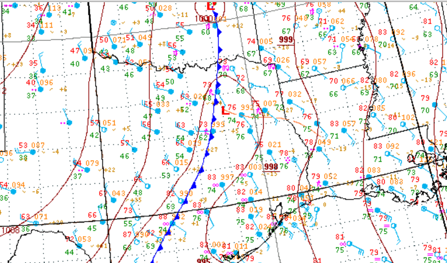
Objective surface analysis from the Weather Prediction Center (WPC) indicated that a cold front extended from near the Red River southward along the I-35 corridor down into the Hill Country. With time, this frontal boundary slowly moved eastward through the DFW Metroplex and Waco. Ahead of this boundary, low level moisture, as indicated by the low to mid 70 degree dewpoint air, surged northward. Coincidentally, surface winds across east Texas back towards the southeast near 2100 UTC (4:00 P.M.) as well which likely increased storm relative helicity, another favorable factor for low level storms. Around 0000 UTC (7:00 P.M.), the WPC denoted some sort of mesoscale boundary (perhaps outflow) in the vicinity of the I-20 corridor. This also likely aided in low level mesocyclogenesis and could be a plausible reason for efficient tornadogenesis that was observed during the afternoon and evening hours on April 29, 2017. This was evidenced by the impressive radar signatures that were observed, even at 80-100 nautical miles from both the NWS Fort Worth Radar located at the Fort Worth Spinks Airport and NWS Shreveport Radar located at the Shreveport Municipal Airport.
| Storm Prediction Center Day 1 Convective Outlooks |
 0600 UTC (1:00 A.M.) SPC Day 1 Convective Outlook |
 1630 UTC (11:30 A.M) SPC Day 1 Convective Outlook |
 2000 UTC (3:00 P.M.) SPC Day 1 Convective Outlook |
The Storm Prediction Center (SPC) continued to highlight the potential for a good coverage of strong to severe thunderstorms in their Severe Weather Outlooks (SWOs). The eastern half of the NWS Fort Worth County Warning Area (CWA) had been placed beneath an “Enhanced” Risk for severe thunderstorms. The progression of the day 1 severe weather outlook (SWODY1) can be examined in the images above.
Click here to return to the top of the page
| Visible & Infrared Satellite Imagery |
 Visible Satellite Imagery |
 Infrared Satellite Imagery |
Satellite imagery on the afternoon of April 29, 2017, indicated that much of North, Central and East TX were all entrenched in widespread cloudiness. This cloudiness gradually decayed through the day as heating occurred. One feature of note was a small cluster of thunderstorms across the Sabine River Valley. While this complex of storms decayed through the afternoon, there appears to be a ring of cumuliform clouds that actually traveled slowly towards the west. Convergence and heating along the front, resulted in the development of deep convection along the I-35 corridor. As the animation plays, however, there appears to be a zone of convergence across East TX. It would appear reasonable that new convection developed quickly. As mentioned above, surface winds were starting to back towards the southeast, and these storms became severe rather quickly.
The IR imagery indicates very cold cloud tops indicative of strong and robust updrafts, which supports severe thunderstorms. Through the evening, convection marches eastward out of the NWS Fort Worth CWA.
Click here to return to the top of the page
| NWS Weather Radar Imagery |
 Fort Worth Spinks WSR-88D Radar Imagery |
 Shreveport WSR-88D Radar Imagery Shreveport WSR-88D Radar Imagery |
Click on any of the above thumbnails for an animated gif of radar imagery on the afternoon of April 29, 2017
(opens in new window)
Click here to return to the top of the page
NWS Fort Worth was very busy during the severe weather episode on April 29, 2017. The FIRST warning (Severe Thunderstorm Warning for Henderson and Navarro counties) was issued at 3:57 P.M. The LAST warning (Severe Thunderstorm Warning for Hopkins, Lamar and Delta counties) was issued at 7:59 P.M.
| NWS Fort Worth Storm Based Warnings |
| NWS Fort Worth Product Archive |
| Severe Thunderstorm Warnings (SVR) | Tornado Warnings (TOR) | Flash Flood Warnings (FFW) | Update Statements (SVS & FFS) |
| Graphical Local Storm Report (LSR) | Final Public Information Statement (PNS) | ||
Select one of the above products in the table to view products issued by NWS Fort Worth during or after the April 29, 2017, tornado event.
Click here to return to the top of the page
| NWS Fort Worth Storm Survey Map |

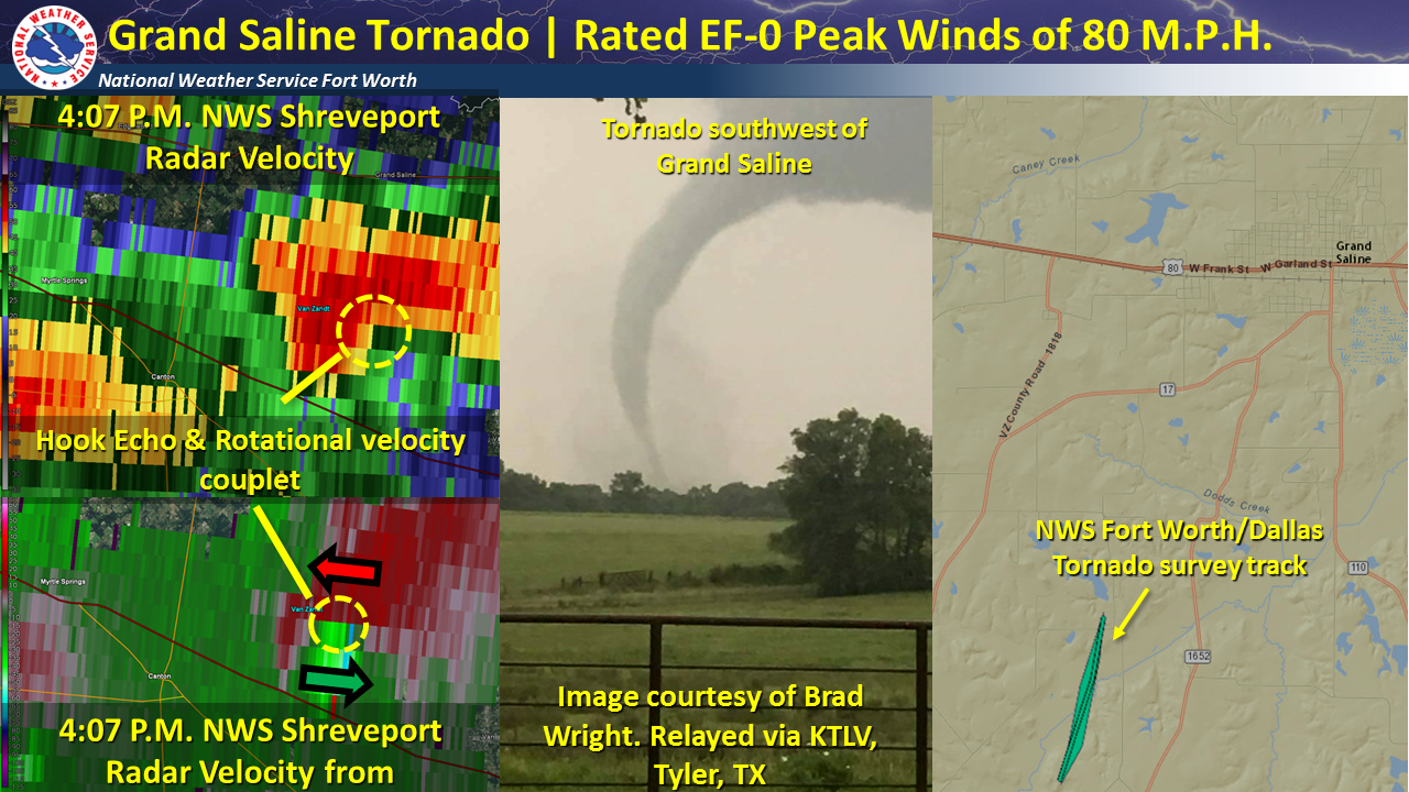
| Tornado #1 Grand Saline |
NWS Fort Worth Survey Results
Survey Summary: A brief tornado was observed just after 4 PM CDT by storm spotters and storm chasers just to the south of the Grand Saline area. The survey team found damage only on trees and this damage was consistent with that of an EF-0 tornado with winds of 80 M.P.H. Rating: EF-0 (estimated peak wind: 80 M.P.H) |
|
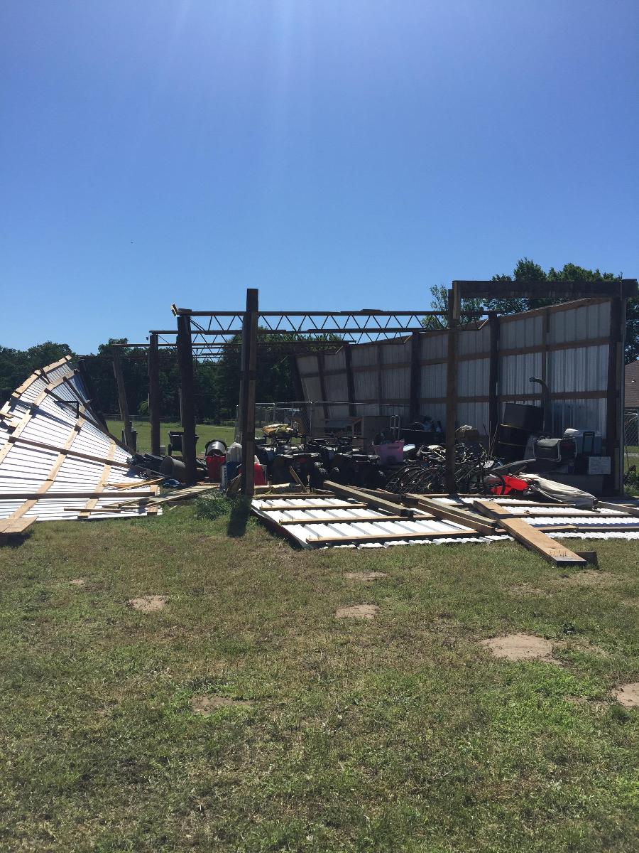
| Tornado #2 East Canton |
NWS Fort Worth Survey Results
Survey Summary: A brief tornado between 5:10 pm - 5:14 pm CDT. It caused damage to trees and a few barns, just southeast of the city center of Canton. This tornado impacted an area that would be affected by a larger tornado roughly one hour later.
Rating: EF-0 (estimated peak wind: 75 M.P.H) |
|
| Tornado #3 Eustace to West Canton |
NWS Fort Worth Survey Results
Survey Summary: This was the strongest tornado in this event. Damage consistent with EF-4 winds of around 180 M.P.H occurred in the community of Old Bethel in Van Zandt County. It began around 5:29 P.M. CDT about 2 miles north of the town of Log Cabin (northwest Henderson Co.) and ended around 6:09 P.M. CDT just north of State Highway 243, located to the west of Canton. The survey team found several homes and trees damaged and destroyed along its path. The most substantial damage was in a narrow corridor near the intersection of Farm-to-Market road 2301 and 2313. This tornado reached its greatest width, roughly 1 mile, as it crossed State Highway 198 where numerous high tension towers were demolished.
Rating: EF-4 (estimated peak wind: 180 M.P.H.) |
|
No photography of this tornado has been received by the NWS Fort Worth office. If you have pictures of this tornado and/or associated damage, please email them to us at sr-fwd.webmaster@noaa.gov. We would greatly appreciate it as it would help us more accurately document this tornado.
| Tornado #4 Henderson County to South Van Zandt County |
NWS Fort Worth Survey Results
Survey Summary: This tornado was from 5:41 P.M. CDT through 6:04 P.M. CDT. It developed northeast of Log Cabin and continued to move northeast, eventually stopping near the intersection of Van Zandt County Road 2903 and FM 1256. Several homes and trees were damage or destroyed along the path.
Rating: EF-2 (estimated peak wind: 125 M.P.H)
|
|
The NWS radar in Fort Worth, located at the Fort Worth Spinks Airport (south Fort Worth), indicated rotation associated with a possible tornado just to the southeast of the city of Eustace, TX. This would be the SECOND tornado that occurred in Henderson County this day. The tornado quickly matured and took on a stovepipe appearance as it crossed Highway 175 in Henderson County. This was perhaps one of the more photogenic pictures taken by spotters and chasers. For a larger image click on the map.
| Tornado #5 East Canton to Emory |
NWS Fort Worth Survey Results
Survey Summary: After tornado #4 dissipated, the supercell cycled and produced another tornado about a mile to the east and northeast of the City of Canton. It quickly grew to a large tornado, becoming nearly a mile wide at its peak width. Several homes, businesses and farm buildings were damaged or destroyed in a 40 mile continuous path. This tornado was on the ground for approximately 80 minutes (6:08 P.M. CDT – 7:28 P.M. CDT). This tornado tracked through a majority of Van Zandt and Rains counties leaving a trail of destruction.
Rating: EF-3 (estimated peak wind: 145 M.P.H.) |
|
Radar signatures are from the NWS radar located at the Fort Worth Spinks Airport (south Fort Worth). The bottom left images were taken at around 6:25 P.M. CDT and show a strong rotational velocity signature indicative of a tornado. At this range, it's probable that the tornado was strong (at least EF-2 intensity). Storm spotters captured what appears to be a wedge tornado just to the east of Canton. The top left imagery is also from the Fort Worth radar, but a little later in the evening at around 7:02 P.M. CDT. It also indicates the potential for a strong and storm spotters just east of Emory photographed a large cone tornado during the evening hours of April 29, 2017. For a larger image click on the map.
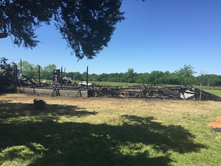
| Tornado #6 Miller Grove to South Cumby |
NWS Fort Worth Survey Results
Survey Summary: A tornado occurred between 5:32 P.M CDT and – 5:50 P.M. CDT. This tornado briefly had multiple vortices but generally maintained a width of around 100 yards. It traveled north along the County Road 1131 with mostly tree damage observed by the survey team. A metal barn was destroyed (near County Road 1131 and County Road 1120) and damage to a home along FM 275 south of I-30 near the end of the track. This home burned after a large tree limb fell on the main utility pole which then fell upon the house.
Rating: EF-0 (estimated peak wind: 85 M.P.H) |
|
Radar signatures are taken from the NWS Fort Worth radar located at the Fort Worth Spinks Airport (south Fort Worth). At times, this small supercell produced a multiple vortex tornado per video taken by citizens near Miller Grove. The tornado remained over mostly rural areas of Hopkins Co and based on the damage, an EF-0 rating was assigned. For a larger image click on the map.
| Tornado #7 Rural Southwest Van Zandt County Tornado |
NWS Forth Worth Survey
Brief tornado between 7:13 pm – 7:15 pm CDT. The tornado was observed by residents of the area, south of Van Zandt County road 2308. It occurred over open fields.
Rating: EF-0 (estimated peak wind: 85 M.P.H) |
|
Unlike the other tornadoes during this event, this tornado appeared to be more associated with processes more consistent with those of a Quasi Linear Convective System or QLCS-type tornado. This tornado was brief and occurred mainly over rural portions of southwestern Van Zandt. For a larger image click on the map.
The peak in severe weather, more specifically tornadic activity, typically occurs during the months of April and May. Including the April, 29, 2017, tornadoes---Since the year 1950, 495 tornadoes have touched down across the present day NWS Fort Worth area of responsibility. For other months, please see the North and Central TX Tornado Climatology. This section will examine and highlight some noteworthy tornado events and outbreaks across North and Central TX. Note, tornado outbreak is defined here as a day in which at least 10 confirmed tornadoes (NOT tornado reports) or greater occur in a span of 24 hours.
| Noteworthy April Tornado Outbreaks/Events across North & Central TX since 1950 | |||
| Date | Number of Confirmed Tornadoes |
Number of Strong Tornadoes (F/EF-2 or Greater) |
Noteworthy Event? |
| 4/26/1994 | 26 | 3 tornadoes rated F-2 | Highest # of confirmed tornadoes in FWD CWA in 24 hour time period |
| 4/3/2012 | 17 | 1 tornado rated EF-3 | 4 tornadoes rated EF-2 | TOR Emergency for Dallas & Fort Worth |
| 4/19/1995 | 17 | 1 tornado rated F-2 | Tornado near Fort Worth |
| 4/26/2015 | 16 | No strong tornadoes | Rio Vista "wedge" |
| 4/29/2017 | 7 | 1 EF-4 | 1 EF-3 | 3 EF-2 | Canton |
Click the date for a map of the tornado tracks for a given map.
While the number of tornadoes from April 29, 2017, is on the lower end of tornado events in April, the tornado that traveled from the community of Jackson and occluded was the highest rated tornado in Van Zandt County since 1950. Below is a graphic that details some of the more violent tornadoes across Van Zandt County. Van Zandt County has already set a record number of tornadoes in a calendar year at SEVEN.
| Historic Van Zandt County Strong and Violent Tornadoes |

Click the image for a larger view.
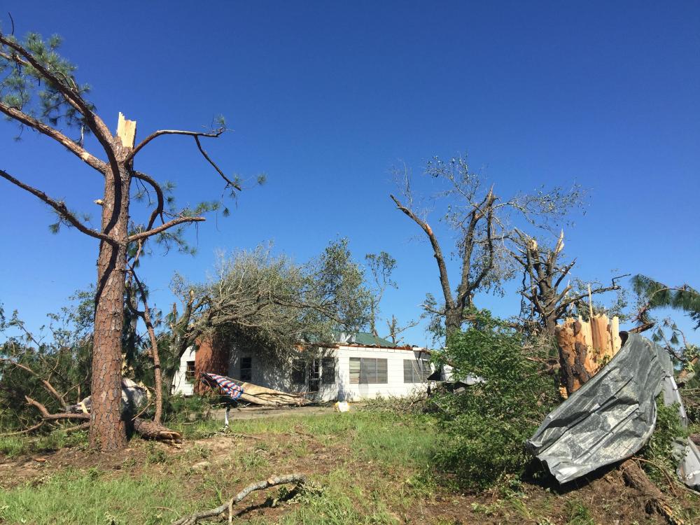
| Tornado damage near Purtis Creek |
 |
 |
 |
 |
 |
 |
 |
 |
 |
 |
 |
| Tornado damage near Buck Branch |
 |
 |
 |
 |
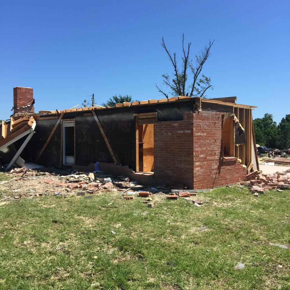
| Tornado damage near Canton |
 |
 |
 |
 |
 |
 |
 |
 |
 |
 |
 |
 |
 |
 |
 |
 |
| Tornado damage near Fruitvale |
 |
 |
 |
 |
| Tornado damage near Emory |
 |
 |
 |
|
|
|
|
|
|
 |
 |
| Tornado damage in rural Henderson County |
 |
 |
Miller Grove to South Cumby (EF-0)
| Tornado damage near Miller Grove |
 |
 |
 |
Click here to return to the top of the page
These storms reinforce the need to have a severe weather plan in place and practice it frequently. Furthermore, now is the time to get your NOAA weather radio ready. Weather radios will alert you of hazardous weather...whenever it strikes!
For more details on the Enhanced Fujita Scale, visit www.spc.noaa.gov/efscale/
Special thanks to those who helped us document this event by sending us photos and videos of these tornadoes.


