National Weather Service United States Department of Commerce

Heat Continues for the East and South-Central U.S.; Strong to Severe Storms Across the Mid-Atlantic and Northeast

The extremely dangerous heat wave continues across the East Coast and much of the South-Central U.S. today. Record high temperatures are expected for some areas especially across the Mid-Atlantic where extreme heat risk conditions reside. There is a Slight Risk (level 2 of 5) of severe thunderstorms today for the northern Mid-Atlantic into portions of southern New England. Read More >


April 10-11, 2011 North Texas Severe Storms

 
Thunderstorms erupted late Sunday night into early Monday morning across North Texas as a dry line and its trailing cold front pushed through the region. Preliminary storm survey results indicate 4 tornadoes occurred. Two in Jonhson County, one in Kaufman County, and one in Hunt County. Numerous reports of wind damage were received, with some of the worst in Ellis and Dallas Counties.

The information below is PRELIMINARY and subject to change as new data arrives.


Radar loop of storms that brought severe weather to North Texas on April 10th and 11th.

Map showing preliminary storm reports.

Radar Loop From KFWS. (Larger View)

Preliminary Storm Reports. (Larger View)


The first tornado occurred in Johnson county near Rio Vista. This tornado began near County Road 1210 south of Pat Cleburne Lake and traveled 1.54 miles to the east. The first signs of damage were to a garage and a house was shifted off its foundation. Several trees were also knocked down. Near the end of the track, the tornado damaged 5 homes with one of the homes sustaining heavy damage. This tornado was preliminarily rated an EF1 with maximum winds of 100-110 mph. The path width was approximately 100 yards.

The second tornado also occurred in Johnson county and was also preliminarily rated an ef1 tornado. This tornado occurred in the city of Alvarado, just southwest of the intersection of Interstate 35W and Highway 67. A mobile home was overturned resulting in two minor injuries. The equine vet building was also damaged and 4 other commercial buildings were damaged. This tornado was approximately 150 feet wide, 200 yards long, with estimated winds around 90 mph.

In addition to the tornado in Alvarado, straight line winds also significantly damaged the medicine chest pharmacy causing a wall to collapse.

Radar close up of Johnson County severe thunderstorms.


The third tornado occurred in Kaufman County, on the north side of Forney, near the intersection of FM 740 and Lovers Lane. This tornado was about 60 yards wide and approximately a half mile long. Five homes suffered roof damage during this tornado. This tornado was preliminarily rated an EF1 with winds of 100-105 mph.

Radar close up of Kaufman County thunderstorms.

Picture of a home damaged near Forney, Texas.
Damage near Forney, Tx


The fourth tornado began near the town of Cash in Hunt County and ended near the intersection of FM 1564E and Highway 69. Picture of a home that was damaged by a tornado near Cash, Texas
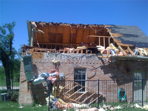
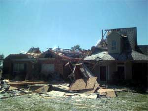
The winds with this tornado were estimated to be between 100-110 mph and was preliminarily rated an EF1. The tornado track was nearly 7 miles long but the damage was non-continuous along the path. The tornado was 200 yards wide. The first damage noted was to a mobile home, a manufacturing plant, and two metal buildings in Cash. From there the tornado tracked northeast damaging trees, sheds, carports, and a few roofs (minor damage) along the path. The tornado significantly damaged a home near 1564E (image above) and then continued on to damage 5 more mobile homes near the end of the track. One of the mobile homes was destroyed. 

Radar close up of Hunt County thunderstorms.


It was also determined that straight line wind damage occurred in Bosque, Dallas, and Ellis Counties. The winds that caused the damage in Waxahachie in Ellis County were determined to be around 80 mph. The winds that caused damage to a church in Lancaster in Dallas County were estimated at 95 mph.

Picture of a church that as damaged in Lancaster.
Damage to Church in Lancaster

 
Radar close up of Ellis County thunderstorms.