|
The Paris Storm
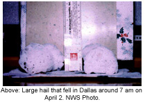
Shortly before 3 pm , the Texas supercell moved into Grayson County , producing marble to golf ball sized hail in Sherman . The storm progressed east into Fannin County , dropping tennis ball sized hail near Ravenna at 3:20 pm. Large hail continued to fall from Ravenna to the Fannin/Lamar County line, with some hailstones as large as 6 inches in diameter.
 At 3:20 pm , a Bonham police officer reported a rotating wall cloud south of Ravenna . Shortly after this report, the first tornado touched down approximately 3 miles south-southeast of Ravenna . The tornado moved east at nearly 50 mph toward the rural Smith community and Farm Road 1743. At 3:20 pm , a Bonham police officer reported a rotating wall cloud south of Ravenna . Shortly after this report, the first tornado touched down approximately 3 miles south-southeast of Ravenna . The tornado moved east at nearly 50 mph toward the rural Smith community and Farm Road 1743.
 Briefly, two tornadoes were on the ground simultaneously. With a separate area of rotation just north from the first twister, a small tornado touched down near Farm Road 898 north of Bonham, causing only tree damage near Lake Bonham. This second tornado dissipated shortly after touching down. Briefly, two tornadoes were on the ground simultaneously. With a separate area of rotation just north from the first twister, a small tornado touched down near Farm Road 898 north of Bonham, causing only tree damage near Lake Bonham. This second tornado dissipated shortly after touching down.
In Fannin County , 6 homes, 2 mobile homes, 10 barns, and numerous powerlines and outbuildings were destroyed. The most significant damage occurred just north of Bonham, in Allen’s Chapel and Allen’s Point. One person was killed and another injured in Fannin County .
After passing near the Allen’s Point community, the tornado crossed into Lamar County . The tornado continued to produce damage in western Lamar County before dissipating about 7 miles west of Paris shortly before 4 pm .
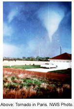
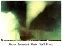
After the initial tornado dissipated west of Paris , another tornado developed rapidly near Campbell Road and Loop 286 in far northwest Paris . The tornado tracked across the city, destroying homes, businesses, trees, and automobiles. The twister continued east through Reno and Blossom, damaging or destroying 75 homes and businesses in Reno and at least 17 in Blossom.
Over 465 homes and apartments were damaged or destroyed as the tornado carved a 200-300 yard wide path across north Paris . The majority of homes received F2 to F3 damage, with a handful experiencing F4 destruction. F2* damage suggests wind speeds from 113-157 mph, F3* from 158-206 mph, and F4* from 207-260 mph.
In northwest Paris , a large lumber yard was destroyed and caught on fire as a result of the tornado. A mobile home park near the lumber yard was leveled, with debris falling hundreds of yards away. The majority of the mobile home park residents received early warnings and evacuated their homes. However, four people did not leave. Two of these people were killed, and the other two injured.
Overall, 10 people died in Paris, 170 were injured, and 1000 were left homeless. The estimated cost of damage was $50 million.
Large Tornado Struck Southeast Oklahoma
North of the Paris storm, a strong supercell produced an F5 tornado across southeast Oklahoma . This tornado developed near Speer and moved across the Hugo Reservoir, north of Valliant to just south of Broken Bow over portions of Choctaw and McCurtain counties. The path length was over 53 miles and the maximum width of the tornado was 1.5 miles as it crossed near Golden. The tornado was reportedly multiple vortex at times and a solid funnel at others. A motel sign in Broken Bow was found 30 miles away in Arkansas . 30 to 40 houses were destroyed, as well as one church, an airplane, and numerous barns, chicken houses, vehicles, powerlines, and farm equipment. No one was killed, but 29 people were injured. The tornado caused about $8 million in damage.
F5* rating indicates wind speeds from 261-318 mph.
 Getting the Word out Early Getting the Word out Early
While 11 people lost their lives in Fannin and Lamar counties, the death toll could have been much higher if not for the hard work of local police and fire agencies, radio stations, amateur radio operators, the Civil Defense director, as well as access to NOAA weather radio. In Fannin County , reports relayed by local law enforcement indicated that several people near Bonham survived the tornado due to the quick warnings provided by local radio stations. In Paris , citizens had 20 to 30 minutes of warning from local radio stations, law enforcement, and NOAA weather radio before the twister struck.
Now is the Time to Plan
Does everyone in your family know what to do in the event of a tornado?  Now is the time to plan where to go in the event a tornado warning is issued for your area. A few moments of planning now can save your life when precious seconds count during a dangerous storm. Visit https://www.srh.noaa.gov/fwd/?n=skywarn for help with finding safe locations in your home, school, or office. Now is the time to plan where to go in the event a tornado warning is issued for your area. A few moments of planning now can save your life when precious seconds count during a dangerous storm. Visit https://www.srh.noaa.gov/fwd/?n=skywarn for help with finding safe locations in your home, school, or office.
 Don’t forget to check the batteries in your NOAA weather radio. Also be sure to listen for weekly radio tests from your National Weather Service in Fort Worth on Wednesdays around 11 am and 6 pm. Don’t forget to check the batteries in your NOAA weather radio. Also be sure to listen for weekly radio tests from your National Weather Service in Fort Worth on Wednesdays around 11 am and 6 pm.
* Changes in the Fujita Scale
In 2007, improvements were made to the Fujita scale. These improvements, known as the Enhanced Fujita scale, allow for more accurate wind speed estimates due to varying types of construction and building materials. The tornado ratings and wind speeds used in this article are based on the original Fujita scale. For more details on the Enhanced Fujita scale, visit http://www.spc.noaa.gov/faq/tornado/ef-scale.html.
Credits
Storm details were taken from NCDC Storm Data April 1982, Volume 24, Number 4. Data was also gathered from Significant Tornadoes by Thomas P. Grazulis.
|