
Isolated to scattered severe thunderstorms may produce large hail, severe wind gusts, and heavy rain and isolated flash flooding across portions of the southern and central Plains. Showers and thunderstorms are expected to linger cross the South the next couple of days. Heavy showers are creating a flash flooding threat around Kauai and Niihau, Hawaii. Read More >
October 8-9, 2011
A large, slow-moving upper-level low pressure system brought much needed rainfall to drought-stricken North Texas. The precipitation forecast for Saturday and Sunday looked like this:
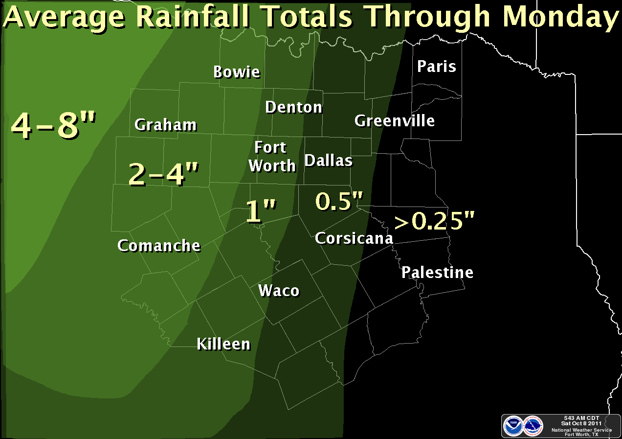
Graphicast issued early Saturday morning.
Showers and thunderstorms initiated in West Texas early Saturday morning (October 8) and quickly developed into a slow, eastwardly progressing line. This line reached the western portions of North Texas by Saturday afternoon and Interstate 35 by Saturday night. Moderate to heavy rainfall occurred west of I-35 for most of the night Saturday. By Sunday morning, numerous locations had 24-hour rainfall totals over 4 inches:
· Comanche 8.30”
· Dublin 6.10”
· Stephenville 5.78”
· Cleburne 5.53”
· Mineral Wells 5.14”
· Goldthwaite 5.00”
· Weatherford 4.79”
· Breckenridge 4.77”
· Hico 4.72”
· Waco Lake 4.35”
· Waco Airport 4.28”
· Palo Pinto 4.00”

Graphicast issued Sunday morning. The image is 24-hour radar estimated rainfall totals. Actual rainfall totals are listed for a few locations.
Light to moderate rain continued throughout the day Sunday for areas along and east of I-35. A large area of thunderstorms developed across south Texas, which limited the amount of moisture available to the showers across North Texas. As a result, 24 hour rainfall amounts for Sunday were much less than those on Saturday night:
· Gunter 0.89”
· Gainesville 0.82”
· Collinsville 0.60”
· Clifton 0.52”
· Prosper 0.47”
· McKinney 0.32”
· Carrollton 0.22”
· Lewisville 0.20”
Here are the preliminary 72-hour rainfall totals, by county, ending at 1 PM Monday, October 10. Only locations with totals greater than 1” are listed.
...Anderson...
NO REPORTS OVER ONE INCH
...Bell...
GRK ROBERT GRAY AP 3.49
STIT2 STILLHOUSE HOLLOW 3.05
BLNT2 BELTON LAKE 2.88
KIET2 KILLEEN 2.49
YOUT2 YOUNGSPORT 2.44
HLR FORT HOOD AAF 2.14
TMPT2 TEMPLE RAWS 1.55
LRIT2 LITTLE RIVER 1.26
TPL TEMPLE AWOS 1.05
...Bosque...
AQLT2 AQUILLA 5.12
VMAT2 VALLEY MILLS 3.93
CNFT2 CRANFILLS GAP 3.85
MGNT2 MORGAN 3.73
CTNT2 CLIFTON 1.48
...Collin...
GUNT2 GUNTER 2.54
FRST2 FRISCO 1.79
PRPT2 PROSPER 1.68
DCCT2 DALLAS ALERT 109 1.58
MCKT2 MCKINNEY 1.50
TKI MCKINNEY ASOS 1.35
LVNT2 LAKE LAVON 1.04
...Comanche...
COET2 COMANCHE 8.35
COAT2 COMANCHE RAWS 8.32
DSBT2 DELEON 6.00
DLLT2 DELEON 5.30
PCTT2 PROCTOR LAKE 5.05
...Cooke...
VVWT2 VALLEY VIEW 4S 3.10
MUTT2 MUENSTER 3.07
GAIT2 GAINESVILLE 1N 2.69
GLLT2 GAINESVILLE 2.11
MNTT2 MUENSTER 1.84
...Coryell...
GAET2 GATESVILLE 4.00
PICT2 PIDCOKE 2.29
GAST2 GATESVILLE 2.01
...Dallas...
GPRT2 GRAND PRAIRIE 2.04
CDHT2 CEDAR HILL S.P. RAWS 1.67
RBD DALLAS RED BIRD ASOS 1.65
JPLT2 LAKE JOE POOL 1.37
DALT2 DALLAS 1.20
CART2 CARROLLTON 1.15
GPET2 MOUNTAIN CREEK LAKE 1.10
DWRT2 WHITE ROCK CREEK AT GREENVILLE AVE 1.06
...Delta...
NO REPORTS OVER ONE INCH
...Denton...
DCJT2 JUSTIN 3.28
JSTT2 JUSTIN 2.98
SGET2 SANGER 2.58
DTO DENTON ASOS 2.16
ROAT2 ROANOKE 1.90
DTNT2 DENTON 2SE 1.77
RRLT2 LAKE RAY ROBERTS 1.10
...Eastland...
LLET2 LAKE LEON 5.01
...Ellis...
MLOT2 MIDLOTHIAN #2 1.70
WAXT2 WAXAHACHIE 1.55
LWWT2 LAKE WAXAHACHIE 1.07
...Erath...
DBNT2 DUBLIN 6.20
MNMT2 MORGAN MILL 6.10
SEPT2 STEPHENVILLE 1N 5.93
...Falls...
RSBT2 ROSEBUD 1.43
...Fannin...
NO REPORTS OVER ONE INCH
...Freestone...
NO REPORTS OVER ONE INCH
...Grayson...
SHET2 SHERMAN 2.38
COVT2 COLLINSVILLE 2.21
CVET2 COLLINSVILLE 2.16
...Hamilton...
HICT2 HICO 4.80
HMLT2 HAMILTON 3.05
...Henderson...
NO REPORTS OVER ONE INCH
...Hill...
AQAT2 AQUILLA CREEK BLW DAM 4.73
BUMT2 BLUM 4.66
ALAT2 AQUILLA LAKE 4.05
ITAT2 ITASCA 3.40
HBOT2 HILLSBORO 2.20
BBDT2 BRANDON 1.47
...Hood...
GRNT2 GRANBURY 5.48
LIPT2 LIPAN 5.15
GRYT2 GRANBURY RAWS 5.07
CSNT2 CRESSON 4.93
GBYT2 LAKE GRANBURY 2.92
...Hopkins...
NO REPORTS OVER ONE INCH
...Hunt...
NO REPORTS OVER ONE INCH
...Jack...
JSBT2 JACKSBORO 6.00
JAKT2 JACKSBORO 4.37
TANT2 ANTELOPE 4.24
TVTT2 TRUCE 3.64
TBMT2 BEAR MTN REPTR (POST OFFICE) 3.36
TJOT2 JOPLIN 1.83
TBWT2 LAKE BRIDGEPORT REPE 1.45
...Johnson...
CLET2 CLEBURNE 4.35
ALRT2 ALVARADO 2NNW 3.30
VNST2 VENUS 2.35
...Kaufman...
NO TOTALS OVER ONE INCH
...Lamar...
NO TOTALS OVER ONE INCH
...Lampasas...
KEMT2 KEMPNER 5.14
LTCT2 LOMETA 4.27
LMPT2 LAMPASAS 11 WNW 3.84
LMOT2 LOMETA 3.49
NNXT2 LAMPASAS 3.02
...Limestone...
NO REPORTS OVER ONE INCH
...Leon...
NO REPORTS OVER ONE INCH
...McLennan...
ACT WACO ASOS 5.83
ACTT2 WACO LAKE 5.02
CWFT2 CRAWFORD 3.30
MEGT2 MCGREGOR RAWS 2.95
MCGT2 MCGREGOR 2.43
CRFT2 CRAWFORD 1.72
...Milam...
DAVT2 DAVILLA 1.45
THDT2 THORNDALE 1.32
TDCT2 THORNDALE 1.20
...Mills...
GOLT2 GOLDTHWAITE 1WSW 6.40
GECT2 GOLDTHWAITE 5.00
...Montague...
BTAT2 BONITA 4NW 4.83
BOWT2 BOWIE 4.80
BCAT2 LAKE AMON CARTER 4.76
FBTT2 FORESTBURG 5S 4.41
MGUT2 MONTAGUE 4.31
0F2 BOWIE 1.26
...Navarro...
NO REPORTS OVER ONE INCH
...Palo_Pinto...
NO REPORTS OVER ONE INCH
...Parker...
BNCT2 CRESSON 5.56
SGTT2 SPRINGTOWN 4S 5.33
WTHT2 WEATHERFORD 5.15
JFBT2 SPRINGTOWN 4NE 4.55
RMDT2 LAKE WORTH 13WSW (REMUDA) 4.42
DNNT2 DENNIS 4.07
WEAT2 WEATHERFORD 3.97
TWRT2 SPRINGTOWN (WALNUT CREEK) 3.63
TAGT2 AGNES 3.50
...Rains...
NO REPORTS OVER ONE INCH
...Robertson...
NO REPORTS OVER ONE INCH
...Rockwall...
NO REPORTS OVER ONE INCH
...Stephens...
BRET2 BRECKENRIDGE 5.03
BKD BRECKENRIDGE AWOS 3.82
HCLT2 HUBBARD CREEK RESERV 3.13
...Somervell...
GLRT2 GLEN ROSE 5.58
GROT2 GLEN ROSE 4.66
...Tarrant...
NFW FTW JOINT RESERVE BASE 4.39
BNBT2 LAKE BENBROOK 4.29
FBGT2 FORT WORTH BOTANIC GARDEN 4.25
ZZET2 FORT WORTH 4.18
WFTT2 FORT WORTH 4.05
ERMT2 EVERMAN 3.68
BMCT2 MARYS CREEK 3.61
FLWT2 LAKE WORTH 3.57
EAMT2 EAGLE MOUNTAIN LAKE 3.26
FWOT2 FORT WORTH 3.17
FWDT2 NWS FORT WORTH 3.09
ZZGT2 KELLER 2.86
CFBT2 BENBROOK 2.86
WRPT2 FORT WORTH FEDERAL BLDG 2.84
TCET2 CEMENT LAKE 2.75
NRHT2 NORTH RICHLAND HILLS 2.68
ZZAT2 KELLER 2.53
AFW FTW ALLIANCE ASOS 2.42
MNFT2 MANSFIELD 2.20
GKY ARLINGTON ASOS 2.04
TMCT2 MARINE CREEK LAKE 1.88
FWS FORT WORTH SPINKS AP 1.84
GPVT2 LAKE GRAPEVINE 1.78
GPNT2 GRAPEVINE DAM WX STA 1.54
DFW DALLAS/FORT WORTH AP 1.43
...Van_Zandt...
NO REPORTS OVER ONE INCH
...Wise...
BPRT2 LAKE BRIDGEPORT 5.30
LBJT2 LBJ GRASSLANDS RAWS 4.18
AVOT2 ALVORD 4NE 4.14
TBNT2 BOONSVILLE 4.11
TBCT2 ALVORD (BRUSHY CREEK) 3.78
BRPT2 BRIDGEPORT 3.75
LUD DECATUR MUNICIPAL AP 3.59
TCDT2 COTTONDALE 3.49
BOYT2 BOYD 3.28
TGCT2 GARRETT CREEK RANCH 3.20
BRIT2 BRIDGEPORT 2.58
...Young...
SOUT2 SOUTH BEND 6.22
LMGT2 LAKE GRAHAM 5.27
RPH GRAHAM MUNICIPAL AP 1.67

Graphicast issued Sunday night showing radar estimated rainfall totals across Texas.

