|
April 9-10 Severe Weather Outbreak
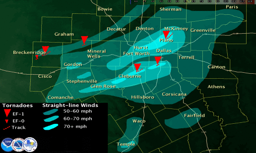
Widespread wind damage resulted from an intense line of thunderstorms that developed into a bow echo as it approached the Metroplex during the early morning hours of April 10. The term bow echo describes the radar presentation of the storms...which accelerates or bows out as a result of the strong winds. While most of the damage surveyed suggested straight-line winds of 70 to 75 mph...at least three tornadoes occurred with the squall line. Two tornadoes occurred with an intense circulation across northeast Johnson County and southern Dallas County. A third tornado was confirmed in Collin County.
Johnson County
The Johnson county tornado touched down north of Alvarado near Happy Hill at approximately 330 am cdt and traveled northeast for approximately 3 miles to Pleasant Point. Several homes sustained significant roof damage...and at least three homes were considered total losses. Many sheds...detached garages...and other small outbuildings were damaged or destroyed. Several trees were uprooted...and at least two fell onto homes. Power lines were downed throughout the area. This tornado is rated ef-1 with estimated wind speeds of 90 to 95 mph. The path width is estimated to be approximately 50 yards wide.
Dallas County
The second tornado touched down in Desoto at approximately 4 am in the central portion of the city along Meadowbrook road just west of Hampton road and traveled east-northeast to near the eastern limits of the city just north of wintergreen road. Again...several homes had substantial roof damage...with one home near the beginning of the track losing the majority of the roof. Many downed trees were observed along with damage to sheds and outbuildings. Power poles and power lines were also downed. This tornado is also rated EF-1 with estimated wind speeds of 95 mph and a path width of 40 yards. more isolated damage was reported southwest of the tornado across southwest sections of Desoto...but this damage was more scattered in nature and appears to be the result of straight-line winds.
Collin County
A third EF-1 tornado occurred in Collin County...affecting southwest sections of Allen northeast into southern sections of McKinney. Winds were estimated at 90 to 95 mph. The tornado touched down near the intersection of North Custer Road and Hedgcoxe Road in Allen...and lifted near the intersection of Highway 75 and Highway 121 in McKinney. The average width of the tornado was approximately two tenths of a mile. In Allen...structural damage occurred to approximately 50 homes...with several suffering loss of portions of the roof. A total of 300 residences reported some type of damage on the property...including downed trees and fences. In McKinney...numerous homes suffered roof damage due to loss of part of the roof or impact from debris from other structures. In both cities...many power poles and power lines were downed. Insured losses in Allen are estimated to approach $5 million. Damage estimates from McKinney were not immediately available. Damage at Collin County Regional Airport in McKinney appears to be the result of downburst winds.
A supercell thunderstorm developed in West Texas during the afternoon of April 9. From Stephens County to the Red River...the storm left a 150-mile path of severe weather. Two tornadoes were confirmed in Stephens County...and a second occurred in Palo Pinto County.
Stephens County
Based on ground and aerial surveys of the damage area...it appears two tornadoes occurred in Stephens County. The first tornado developed along Farm Road 576 east of the Eolian community. Trees and a shed were damaged west of the intersection of F.M. 576 and F.M. 3418. A large metal building was damaged along F.M. 3418 and several large storage containers were blown across the road. This tornado will be rated as an EF-0 with winds of around 80-85 mph. Path length was 2.3 miles and average path width around 75 yards.
The second damage swath started approximately 1/2 mile west of U.S. 183 and south of F.M. 2231. Power pole damage was noted along F.M. 2231 and U.S. 183. Roof and barn damage occurred along U.S. 183 as well.
The most significant damage occurred at and just west of the Stephens county airport. Several homes had considerable damage along county road 150. Several of the airport buildings had overhead doors blown in...roof damage...and damage to some of the girders.
Northeast of the airport...additional damage to power poles was noted near the eastern end of F.M. 2231. The damage swath continued across U.S. 180 between Highways 67 and 207. Damage to mobile homes...roofs...power poles...and storage buildings occurred in this area. This tornado will be rated as an upper-end EF-1 with winds near 110 mph. Path length was 7.1 miles...and the average path width was around 400 yards.
Palo Pinto County
Based on a survey of the damage near the Oran community in northeast Palo Pinto county...it was determined that a tornado affected this area. The damage swath began just west of Oran. Several trees were uprooted or had large limbs snapped. A few homes in Oran had portions of roofs removed. East of Oran on F.M. 52...power poles were snapped. This tornado will be rated an EF-1 with winds of 85-90 mph. Path length was 1.6 miles and average path width was 100 yards.
|


