| The Tornadoes of May 27, 1997 |
Event Summary:
A deadly severe weather episode unfolded across portions of Central Texas during the afternoon and evening hours on Tuesday, May 27th, 1997. This event was made infamous by one of the most powerful tornadoes on record: an F5 which tore through a subdivision of Jarrell called Double Creek Estates in extreme northern Williamson County during the mid-afternoon. Some of the most extreme damage on record occurred with this tornado, and one account states that “the earth was scoured bare, pavement was ripped from roadways, [and] homes and other buildings were completely pulverized” (Lon Curtis, Weather Bulletin). Two F3-rated tornadoes touched down (one each in Bell and McLennan Counties), along with 8 additional tornadoes, one of which (the Prairie Dell Tornado) would eventually grow into the ¾ mile-wide F5 Jarrell tornado.
 Tornadoes of May 27th, 1997 |
 Visible Satellite Animation |
This event was additionally unusual because of the notable lack of upper-level forcing for ascent (lift), and generally light winds through the troposphere--where our weather occurs. In a sense, this day was distinctly lacking two of the four crucial ingredients we typically look for on big severe weather events (strong lift and wind shear, especially near the surface). Yet, over the course of roughly six hours, 20 tornadoes touched down across the Dallas/Fort Worth and Austin/San Antonio forecast areas of responsibility. As we’ll examine in detail on this webpage, the Jarrell tornado was spawned from a lone, southwestward-propagating supercell which initially developed along a cold front near Waco during the early afternoon.
Morning Atmospheric Overview:
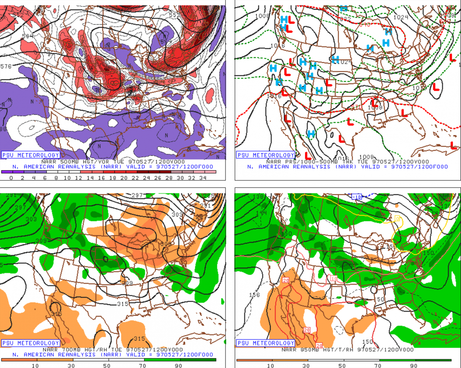
The large scale, (or synoptic scale), weather pattern in place on this date was characterized by a northward-lifting upper-level low pressure system across Nebraska and South Dakota. As a result, the mid-level flow across Texas was actually quite weak--only on the order of 30 knots or so--with most large scale forcing (or lift) displaced well to the north across the Central and Northern Great Plains. This weather pattern was far from a classic severe weather set-up for the region, and certainly one that did not portend the eventual occurrence of 20 tornadoes, one of which would grow into a three-quarter mile wide F5 as it plowed through the town of Jarrell during the mid-afternoon.
 Morning upper-air plot |
 Evening upper-air plot |
(Left): 500 mb (~20,000 feet) analysis, valid at 7 am CDT on May 27th, 1997. An upper-level area of low pressure can be seen lifting across Nebraska and South Dakota. A weak surface low across eastern Arkansas is also associated with a weak cold front which extends southwestward into Central Texas. (Right): same as on the left, except valid at 8 PM that evening.
At the surface, observations during the morning of the 27th (roughly 10 AM CDT) revealed a cold front arcing to the southwest from a surface low near Fayetteville, Arkansas, through the DFW Metroplex, and into the Permian Basin. This would later become an important feature, as thunderstorm updrafts continually regenerated southwestward along the front into the Texas Hill Country during the afternoon. At the same time, visible satellite imagery showed the location of two remnant outflow boundaries laid down by an overnight area of convection across the Piney Woods of East Texas and into southern Arkansas. The southern outflow boundary would later become a focus for thunderstorm initiation east of DFW. An additional, very subtle feature elucidated by visible satellite imagery, was a southwestward-propagating gravity wave, also spawned by the now-decayed overnight convective system, denoted by dashed yellow lines. The gravity wave and cold front all met up just north of Waco near a meso-low, which would eventually become the initiation point for the Jarrell supercell.
 |
 |
The morning upper-air sounding was launched from our office in Fort Worth just as the aforementioned cold front was passing overhead. As a result, while it is not entirely representative of the afternoon environment across Central Texas, there are several keys we are able to glean from this atmospheric sounding:
 |
Surface observations and analysis valid at 18Z, or 1 PM CDT (a), and visible satellite imagery valid at 1215 PM CDT (b).
A few hours later, around noon on the 27th, the surface cold front had sagged southeastward, and was sitting directly overhead at Waco along with the previously analyzed meso-low (Figure 5a) and gravity wave feature, which conceivably was adding to the lift in this region . Thunderstorm initiation was only minutes away at this point, and towering cumulus (just under the cold front line; Figure 5b) was evident on visible satellite near Waco. Farther to the north and east, thunderstorms were also beginning to blossom along the outflow boundary across East Texas.
While we have no NWS proximity soundings sampling the air that would ultimately feed this storm, a sounding was released near Calvert, Texas (just east of Temple) as part of the Texas A&M Convection and Lightning Experiment. The sounding, shown below, was taken just before 3 PM (Wilhelmson and Houston, 2007).
 |
The left panel shows the original sounding, which reveals Convective Available Potential Energy (CAPE) of nearly 5000 J/kg, with just a hint of lingering Convective Inhibition. If this weren’t impressive enough, the same sounding, but modified based on surface conditions a few hours later showed CAPE had increased further to over 6,500 J/kg with no lingering inhibition for surface-based parcels. These are among the more impressive soundings--from a thermodynamic standpoint--you’ll come across. While a bit less representative, modifying the morning sounding from Fort Worth also yields a similarly extreme thermodynamic parameter space:
 |
Event Timeline:
12:00 PM - 2:30 PM
Thunderstorm initiation occurred near Waco just before 12 PM on May 27th, right at the intersection of the cold front and meso-low. If you look closely at the radar loop, you’ll notice a speckled area of reflectivity extending to the southwest along I-35. This “fine line” is the radar sampling the density gradient (temperature contrast) along the cold front. Between 12 and 1 PM, this initial thunderstorm drifted southwestward along the cold front at perhaps 5 mph. Right around this time, the Storm Prediction Center issued Tornado Watch number 338 for the region due to the extreme amounts of instability present:
|
SEL8 BULLETIN - IMMEDIATE BROADCAST REQUESTED THE STORM PREDICTION CENTER HAS ISSUED A EAST TEXAS EFFECTIVE THIS TUESDAY AFTERNOON AND EVENING FROM 115 PM UNTIL 700 TORNADOES...HAIL TO 3 1/2 INCHES IN DIAMETER...THUNDERSTORM WIND THE TORNADO WATCH AREA IS ALONG AND 125 STATUTE MILES EAST AND WEST REMEMBER...A TORNADO WATCH MEANS CONDITIONS ARE FAVORABLE FOR OTHER WATCH INFORMATION... CONTINUE...WW 336...WW 337... DISCUSSION...VERY LARGE HAIL/LOCALLY DAMAGING WINDS AND ISOLATED AVIATION...TORNADOES AND A FEW SEVERE THUNDERSTORMS WITH HAIL |
This initial storm proceeded to rapidly intensify in the extremely unstable airmass. At 12:50 PM, the first Severe Thunderstorm Warning was issued for this storm for McLennan County (remember, the NWS issued “County Based Warnings” until October of 2007). As the storm approached the small town of Lorena, the radars in Fort Worth and Granger (not shown), indicated low-level rotation was increasingly rapidly, which warranted an upgrade to a Tornado Warning at 1:21 PM. Shortly thereafter, this storm produced its first tornado 5 miles southwest of Hewitt, or just outside of Lorena.
This storm then dropped another, albeit brief, tornado as it crossed into Falls County near the town of Bruceville-Eddy. The first significant tornado of the day occurred in extreme southwestern McLennan County on the south side of FM 107, 1.6 miles east-southeast of Moody. This F3 tornado tossed a car and pickup truck several hundred feet and destroyed a residence and farm building during its 20 minute life cycle. This sudden westward jog (from Bruceville-Eddy) was a sign that propagation effects were beginning to more strongly dictate the storm’s motion, and new updrafts would sequentially re-develop, paralleling I-35 over the hours to come.
 |
2:30 PM - 4:00 PM
Around 2:30 PM, the next tornado touched down to the north of the previous weak tornado near Morgan’s Point Resort, on the north side of Belton Lake. As this tornado crossed a bend in the lake, it came ashore near Woodland, where “destruction to trees was nearly total” (NWS Service Assessment) and it “destroyed and damaged ten homes along Rocky Lane” (Lon Curtis). This tornado lifted about 20 minutes later after moving only 1.4 miles.
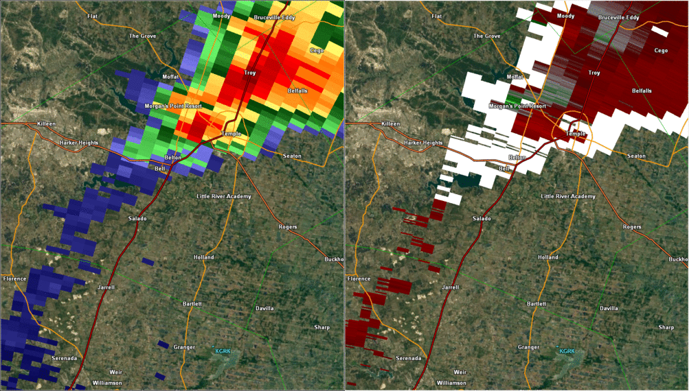 |
Another brief, F0 tornado occurred near the Stillhouse Dam near the split in I-35 and route 190. As this monstrous storm roared into Salado, you’ll notice rotation increase substantially, and the last tornado in the Fort Worth County Warning Area developed near Prairie Dell, which sits right off of I-35 at the Bell/Williamson County line shortly after 3:00 PM. Said Lon Curtis of this latest tornado:
“[It] looked like it was virtually stationary, although the portion of the vortex which was in ground contact was ‘wandering’ in a pasture about 3/10 of a mile from me. Between 3:10 and 3:20 PM, the cloud base portion of the vortex began thickening.” - Lon Curtis (Weather Bulletin)
This was the beginning of one of, if not the most, powerful tornadoes in Texas history. From most accounts, this initial pencil tornado grew into a ¾ mile-wide wedge over the course of a few minutes between Prairie Dell and the outskirts of Jarrell between 3:20 and 3:30 PM. You’ll be able to find more information on the destructive “Jarrell Tornado” on the Austin/San Antonio National Weather Service website.
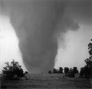
Photos of the May 27th Tornadoes and Damage
 |
 |
 |
 |
 |
 |
References:
Curtis, Lon. “Deadly Texas Fury!” Weather Bulletin: The Official Publication of TESSA. Summer 1997: 1. Print.
Houstoun, A. L., and R. B. Wilhelmson, 2007: Observational analysis of the 27 May 1997 Central Texas tornadic event. Part I: Prestorm environment and storm maintenance/propagation. Mon. Wea. Rev., 135, 701-726.
National Oceanic and Atmospheric Administration, NWS Service Assessment. The Central Texas Tornadoes of May 27, 1997.

