National Weather Service United States Department of Commerce

Severe Thunderstorms in the East Sunday; Excessive Heat Lingers in the Southern U.S. and Returning to California

Scattered damaging winds from severe thunderstorms will be possible across parts of the Northeast and Mid-Atlantic States Sunday. Excessive heat will continue over the southern U.S. Sunday before another round of heat arrives Monday through the central and southern U.S. spreading into the East by Independence Day. California will see excessive heat starting Tuesday. Read More >

Ice Accumulation February 11-12, 2021
Total Snowfall February 14-17, 2021
Ice Accumulation February 14-17, 2021

Ice Accumulation February 14-17, 2021


Facts about the February 11-12th Freezing Drizzle/Rain Event across North and Central TX

  • Freezing drizzle occurred across much of the region which led to a thin coating of nearly invisible ice on many roadways. This resulted in numerous cars sliding off the road as well as several vehicular accidents, including a 100+ cars pile-up that resulted in several fatalities on I-35 W in Fort Worth.
  • The highest ice accumulations up to 0.5" occurred across portions of Central TX.

Facts about the February 14-17th Winter Storm across North and Central TX

  • The official event snowfall for DFW International Airport was 5.0".
  • The official event snowfall for ACT (Waco Regional Airport) was 4.6".
  • Consecutive hours at or below freezing for DFW Airport:​
    • ​93 hours: 5 pm Feb 9th  - 2 pm Feb 13th 
    • 139 hours: 5 pm Feb 13th - Noon Feb 19th (ties for 5th place for most consecutive hours below freezing, and ties for 8th place for most consecutive hours at or below freezing
    • Note: The temperature climbed to 33 degrees briefly from 2 to 5 pm on February 13th. 
  • Consecutive hours at or below freezing for ACT (Waco Regional Airport):​
    • ​205 hours:   10 pm Feb 10th  - 11 am Feb 19th (new record) 
  • This significant event impacted most of Texas and many parts of the country. The image below shows the NWS winter weather products on Sunday February 14th, 2021. Many records were broken across our home state, and Winter Storm Warnings were issued across the entire State of Texas on February 14, 2021.


National Weather Service Warnings, Watches, and Advisories on February 14, 2021


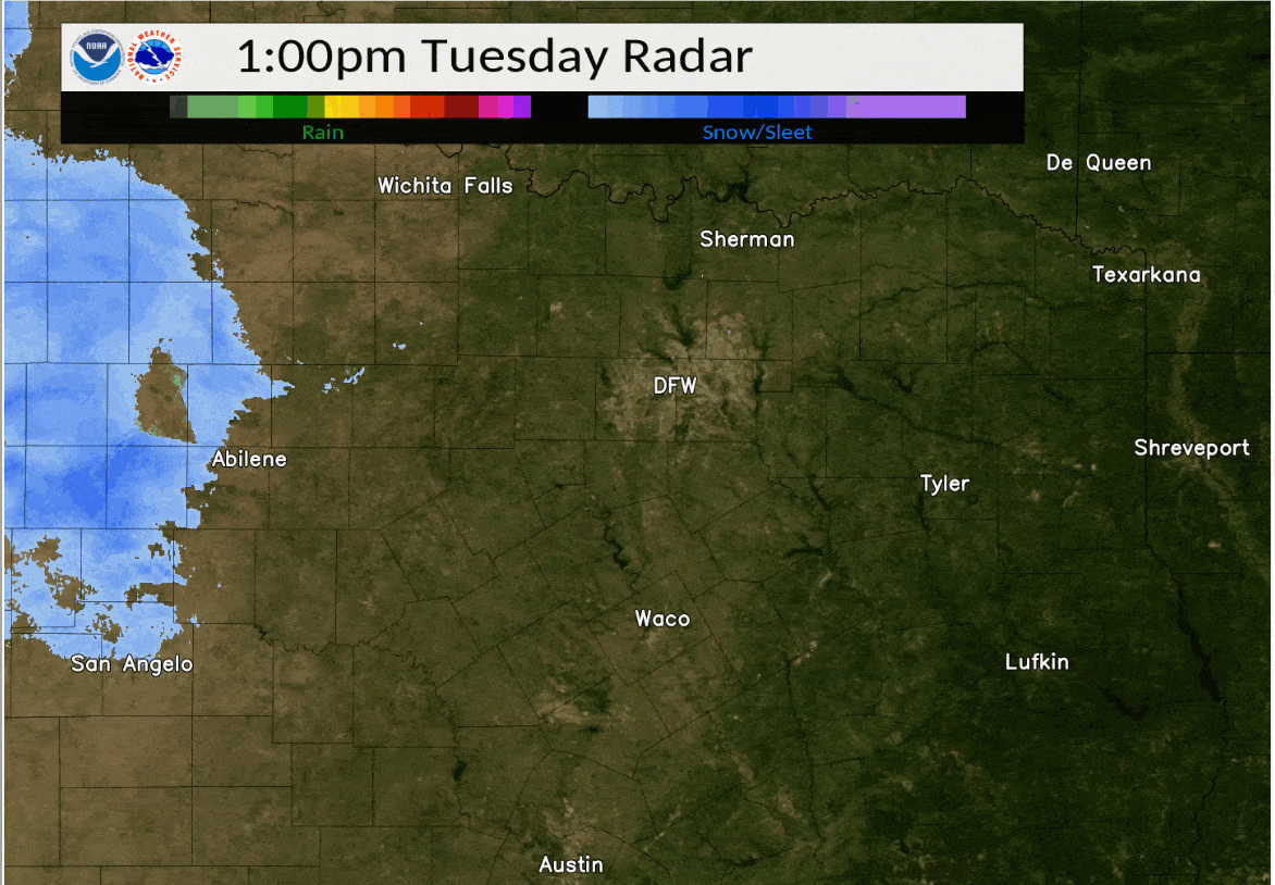
What caused the event? The record cold spell and extended period of wintry weather was caused by the upper level polar vortex dropping south from the north pole and then lingering over south central Canada for more than a week. This allowed cold arctic air to gradually spill southward into Texas. At the same time several upper level disturbances riding the jet stream moved through the area providing lift and moisture for winter precipitation. These disturbances show up as waves or dips in the lines that move in from the west. Ahead of each wave upper level lift increases and moisture is drawn up from the south. Since it was already so cold, this precipitation fell as snow, sleet, and freezing rain.


Upper Air Pattern (Polar Vortex)


Upper Air Pattern (Polar Vortex)


WPC Surface Analysis February 14-17, 2021
WPC Surface Analysis February 14-17 (every 6 hours)


Records for Dallas/Fort Worth and Waco: 

  • The lowest low/minimum temperature was:
    • DFW: -2 deg F on February 16th, 2021                   (All-time record low for DFW: -8 degrees F on February 12,1899)
    • ACT:  -1 deg F on February 16th, 2021                   (All-time record low for ACT:  -5 degrees F on January 31, 1949)
  • On February 15, DFW's high temperature was lower than the record low for the date!
  • Waco's snow events pushed their seasonal total to 9.0", which is the 3rd highest total on record.
  • The coop site at Jacksboro fell to -11 deg F on February 16. This ties the 3rd coldest temperature on record for our county warning area (CWA):
    • -15 deg F at Glen Rose on December 23, 1989
    • -12 deg F at Lampasas on January 16, 1949
    • -11 deg F at Jacksboro on February 16, 2021     (Also -11 deg F at Bowie on December 23, 1989 and at Hico on January 31, 1949)


Dallas/Fort Worth - Climate Stats and Records
Climate Stats and New Records for Dallas/Fort Worth


Waco - Climate Stats and Records
Climate Stats and New Records for Waco


radar loop of February 14-15 with an estimate of precipitation type


radar loop of February 16-17 with an estimate of precipitation type


Snowfall February 14-15, 2021
Snowfall February 16-17, 2021
Total Snowfall February 14-17, 2021


Public Information Statements

Click here to view the Snowfall totals for the Event 1 (February 14-15, 2021)

Click here to view the Snowfall totals for Event 2 (February 16-17, 2021)


NWS Fort Worth Office
NWS Fort Worth Office on Feb 16, 2021 (Temp @ 6:30 am: 0 deg F)
Morning Balloon Launch NWS Fort Worth
Morning Balloon Launch - NWS Fort Worth
NWS Fort Worth (-18 degrees Wind Chill)


DFW Airport Tweet Storm
DFW Airport Tweet Feb 19, 2021
South DFW Airport (near Hwy 360)
South of DFW Airport (near HWY 360)
DFW Airport Tweet 2
DFW Airport Tweet Feb 16, 2021


North TX Neighborhood
Neighborhood - Roanoke, TX
Grand Prairie, TX
Frozen Lake near Grand Prairie, TX
North Texas Roads
 North Richland Hills, TX


Goldthwaite Snow and Ice
Snow and Ice - Goldthwaite, TX
February 14, 2021
Waco, TX
Snow and Ice - Downtown Waco, TX
February 15, 2021
Central TX Roads
 Ice and Snow across Central TX roads 
February 17, 2021


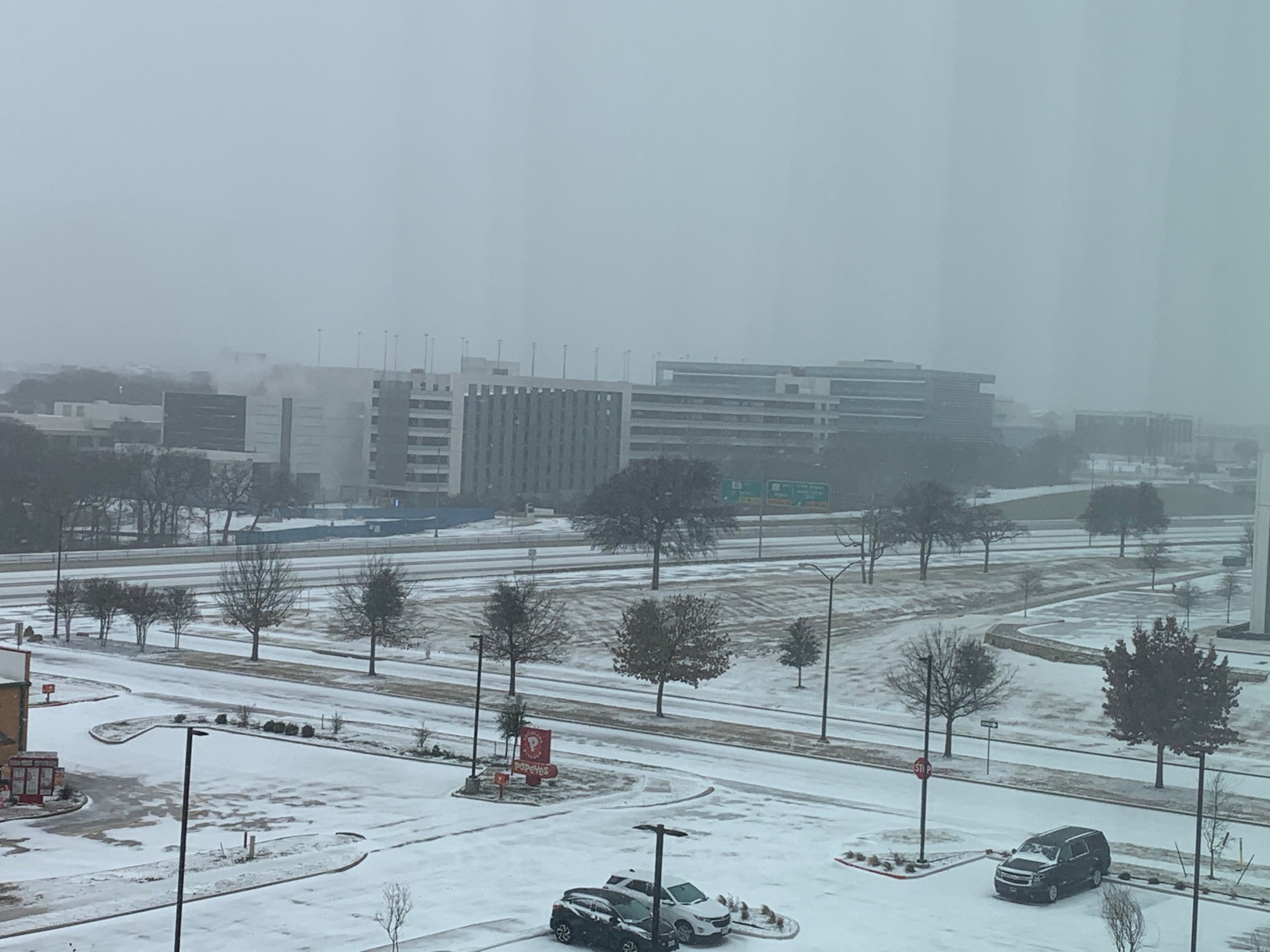
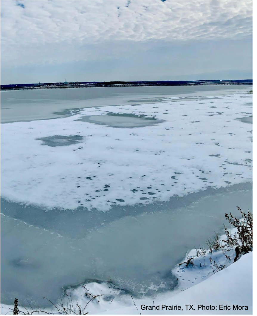
*Photos courtesy of NWS Employees, Partners, public, etc.