July 23, 2000 |
On Sunday, July 23, 2000 a severe thunderstorm moved across Dawson, Hall, and Banks counties. There was considerable wind damage across all three counties along with some large hail. There were also reports of tornadoes. A Storm Survey Team from the National Weather Service Forecast Office in Peachtree City, Georgia visited the area and reviewed all available data the next day. The following are its findings:
Detailed Summary...
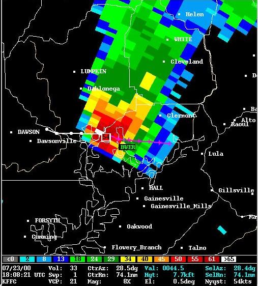
On Sunday, July 23, 2000, a thunderstorm intensified as it moved across Pickens County between 12:30 and 1:00 pm EDT. As this storm crossed into and through Dawson County, it became severe - exhibiting characteristics of a "supercell". The NWS WSR-88D Doppler Radar indicated the primary threat to be large hail and high winds in Dawson County. The National Weather Service issued a severe thunderstorm warning for Dawson County at 1:19 pm EDT. Tree damage and high winds were reported near Dawsonville in Dawson County starting at 1:26 pm EDT. A law enforecement officer's car was spun 360 degrees due to the high winds. At 1:44 pm EDT, the National Weather Service issued a tornado warning for southeast Dawson, southern Lumpkin, and northern Hall Counties based on wind and reflectivity signatures. The storm crossed the Murrayville area around 2:00 to 2:10 pm EDT. Hardest hit was the Leisure Lakes Village, and Muscadine Valley subdivision near Murrayville where the first tornado touchdown occurred. Damage, some severe, was done to between one and two dozen homes there. Residents said they received the tornado warnings and took cover prior to the storms arrival. The storm continued to cross northern Hall County with numerous reports of golf ball size hail and strong straight line winds with trees down but had weakened slightly. The supercell intensified again just south of Lula in Northeast Hall County around 250 pm EDT. This produced another brief tornado touchdown near the McKinley Forest subdivision with damage to around half a dozen homes. The storm traveled east to southeast across western Banks county and produced its final brief tornado touchdown near Welborn Road around 310 pm EDT. Minor damage to one home occurred there. The storm began to weaken in southern Banks County by 330 pm as thunderstorms to the south began to take form and take over.
 for damage photos
 |
 |
 |
 |
 |
 |

