September 16 - 17, 2020
Hurricane Sally made landfall early on the morning of September 16, 2020 along the border of Alabama and Florida, bringing widespread damage to that portion of the coast. After landfall, Sally moved slowly northeastward before picking up speed and moving toward Georgia as it quickly weakened.
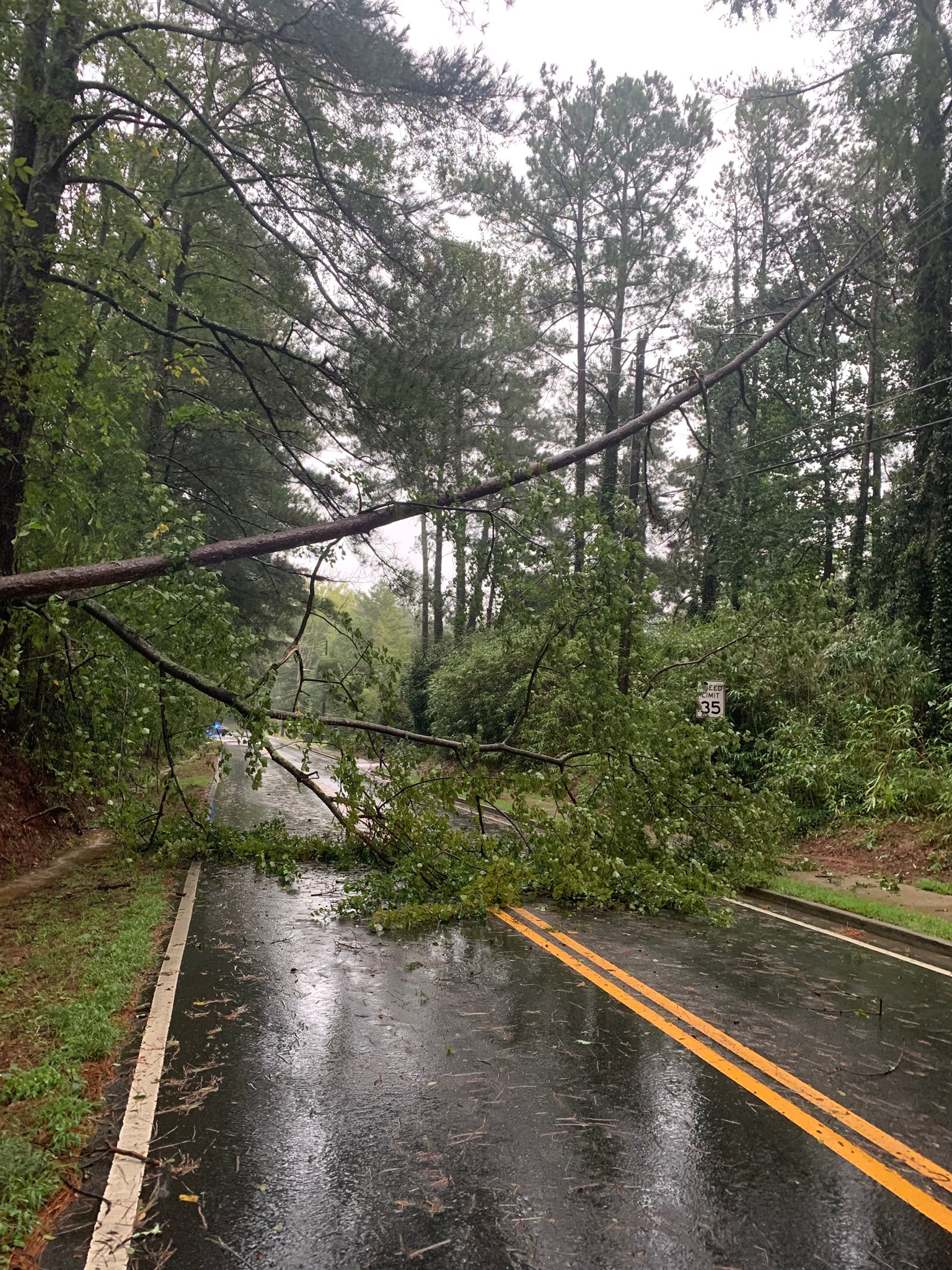
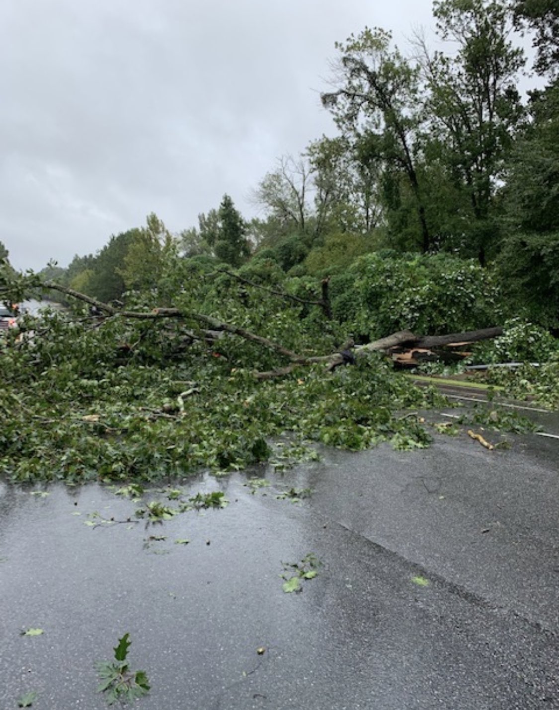
The remnants of Sally brought widespread heavy rainfall and flooding to the local area. Additionally, wind gusts reached 35 - 40 mph, with a peak gust of 43 mph in Columbus. While these winds were light enough to spare the area from much wind damage, some trees were downed given the saturated soils, leading to scattered power outages and damage to some homes.
Hurricane Sally made landfall early on the morning of September 16, 2020 along the border of Alabama and Florida. Heavy rainfall from Sally overspread much of the local area from late on the afternoon of September 16th through the morning of September 17th, especially across most of central Georgia northward into the Atlanta metro. Widespread rainfall totals from 3 - 6" with localized totals of 7 - 8" caused flash flooding in many areas. Lingering flooding of some streams and rivers occurred for several days after the rain had ended. Map of Rainfall Totals from the Remnants of Hurricane Sally Preliminary Recorded Rainfall Totals List By County While Sally weakened sufficiently to prevent widespread damaging winds from affecting the local area, occasional gusts of 35-40 mph were recorded. In combination with the heavy rainfall causing soils to be saturated, some trees were downed, leading to scattered power outages. A tree was downed on East View Rd in Conyers. (courtesy - City of Conyers) Sally Radar Loop: September 16-17, 2020
Heavy Rainfall
Gusty Winds
Radar Loop
Heavy Rainfall & Flooding
Map of Rainfall Totals
Listing of Recorded Rainfall Totals
Flooding Photos

Below is a preliminary 24-hour rainfall total from various weather
stations and reporting sites across the area, broken down by county.
Please note, a few locations ended the observing time between
6-8:00 AM so these are not official storm totals, and not all counties
are represented with reliable weather stations.
...Baldwin County...
Milledgeville 6.5 SSE 4.94 in
2 N Allenwood 4.72 in
Milledgeville 4.56 in
Milledgeville 0.9 N 4.45 in
Milledgeville 4.11 in
...Banks County...
Homer 3.88 in
1.0 N Banks Crossing 2.80 in
0.6 W Hollingsworth 2.00 in
...Barrow County...
Winder 3.9 NNE 4.30 in
Winder 4.17 in
Auburn 1.6 E 4.15 in
Winder 3.80 in
...Bartow County...
Acworth 3.31 in
Cartersville 2.72 in
Cartersville 2.66 in
2.7 SW Cartersville 2.60 in
Cartersville 2.45 in
Adairsville 6.4 WSW 1.64 in
1.7 W Red Top Mountain State 1.08 in
...Bibb County...
Macon 6.93 in
Macon 2.8 NNE 6.80 in
Macon 2.2 NE 6.73 in
Macon 2.5 NNE 6.42 in
Macon 6.3 E 6.39 in
3.6 S Skipperton 6.37 in
3.5 E Lake Tobesofkee 6.12 in
2.0 SW Cross Keys 6.10 in
Macon 5.8 NW 5.91 in
Macon 5.36 in
Macon 5.18 in
Middle Georgia Regional Airp 5.16 in
1.4 E Macon 4.46 in
...Butts County...
Jackson 7 E 4.15 in
...Carroll County...
Temple 0.7 E 4.18 in
0.7 SE Seaton Lake 3.93 in
1.2 N Carrollton 3.80 in
Carrollton 7.0 S 3.77 in
0.9 N Plant Yates 3.71 in
1.0 E Seaton Lake 3.51 in
1.2 N Carrollton 3.48 in
Carrollton 3.2 SW 3.27 in
2 S Carrollton 3.25 in
3.5 SW Bowdon 2.84 in
...Catoosa County...
Tunnel Hill 4.8 N 0.40 in
Fort Oglethorpe 0.25 in
2.0 E Ringgold 0.23 in
0.9 W Ringgold 0.22 in
2.6 NW Boynton 0.19 in
...Chattahoochee County...
Ft Benning Colum 7.13 in
Fort Benning 5.73 in
...Chattooga County...
Conasauga Portable 1 1.05 in
Summerville 9.4 ENE 1.00 in
Summerville 0.79 in
...Cherokee County...
Woodstock 4.58 in
1.4 S Lebanon 3.96 in
Acworth 5.5 NE 3.73 in
Woodstock 3.61 in
1 SE Bridgemill 3.59 in
Hobgood Park 3.48 in
2.2 NE Canton 3.37 in
Woodstock 3.23 in
Canton 1.9 WNW 3.19 in
Ball Ground 3.06 in
1.7 S Lake Arrowhead 3.04 in
Holly Springs 1.0 NNE 3.03 in
Woodstock 2.91 in
2 NNW Canton 2.57 in
2.4 SW Ball Ground 2.56 in
Alpharetta 2.25 in
1.6 NE Canton 1.76 in
Ball Ground 0.5 NNW 1.75 in
...Clarke County...
Athens 4.40 in
Athens 3.8 WNW 4.23 in
Athens 4.5 SE 3.80 in
0.8 N Athens 3.71 in
Athens 7.6 SE 3.51 in
Winterville 0.4 W 3.41 in
0.7 W Winterville 3.41 in
Gaines School 3.7 SE 3.36 in
Athens 3.6 WNW 3.22 in
Winterville 3.20 in
Athens 3.6 SSE 3.05 in
Athens 3.2 NW 2.53 in
Athens 4.6 SE 2.34 in
...Clayton County...
0.7 N Jonesboro 4.48 in
Riverdale 3.0 WSW 4.03 in
0.7 W Jw Smith Reservoir 3.91 in
Atlanta HJI Airport 3.89 in (through 8 AM Sept 17)
...Cobb County...
Sandy Springs 5.85 in
2.0 N Vinings 5.43 in
1 SW Kennesaw 4.99 in
3 N Due West 4.78 in
Smyrna 4.76 in
2 ESE Sweat Mountain 4.65 in
Mableton 4.54 in
Marietta 9.0 NE 4.34 in
Marietta 4.10 in
2.5 W Mount Bethel 4.08 in
0.7 E Vinings 4.06 in
Marietta 4.05 in
Sandy Springs 3.2 WNW 4.02 in
2.0 W Mount Bethel 4.02 in
1 NNE White Water Park 3.99 in
2 E Dobbins Air Reserve Base 3.92 in
3.0 NE Six Flags Over Georgi 3.89 in
0.9 W Austell 3.81 in
1.6 N Austell 3.79 in
Powder Springs 2.5 NNW 3.76 in
3.2 S Woodstock 3.74 in
Dobbins AFB Mari 3.72 in
2.5 SW Woodstock 3.68 in
2 NNE Mableton 3.61 in
2 ENE Due West 3.60 in
Marietta 3.54 in
Marietta Mccolum 3.54 in
Marietta 3.53 in
Marietta 3.52 in
2 SSE Jim R Miller Park 3.44 in
1 N Vinings 3.31 in
Smyrna 3.29 in
Marietta 3.18 in
Kennesaw 5.6 SW 3.16 in
Marietta 5.6 WSW 3.10 in
2 E Mableton 2.95 in
1 WNW Smyrna 2.94 in
3 N Mount Bethel 2.85 in
1 NE Dobbins Air Reserve Bas 2.85 in
...Coweta County...
Senoia 0.9 ENE 5.06 in
Sharpsburg 6.0 N 4.56 in
Newnan 2.6 W 4.39 in
Newnan 4.33 in
Newnan 2.4 N 4.15 in
Cannongate 4.05 in
2.7 W Peachtree City 3.96 in
Newnan 3.77 in
Newnan 5.7 W 3.71 in
Newnan 7 WSW 3.60 in
Newnan 3.39 in
Yates 3.10 in
Newnan 3.02 in
...Crisp County...
Cordele 10.4 SW 4.05 in
...Dade County...
Menlo 0.29 in
Trenton 5.8 S 0.24 in
Trenton 0.11 in
...Dawson County...
1.2 NE Dougherty 4.70 in
Dawsonville 3.55 in
3.2 N Hightower 3.10 in
3.3 N Lumpkin 2.70 in
3.6 S Juno 2.60 in
Ellijay 1.78 in
Dougherty 1.44 in
0.5 SE Dougherty 1.13 in
...DeKalb County...
1 NE Stone Mountain 6.06 in
Dunwoody 5.87 in
Tucker 1.3 ENE 5.65 in
Dunwoody 5.25 in
1.4 N Stone Mountain 5.23 in
1.2 NW La Vista 5.20 in
North Decatur 2.6 N 5.06 in
2.6 N Brookhaven 5.04 in
1 SSW Dunwoody 4.93 in
2.3 N Scottdale 4.85 in
Tucker 4.81 in
Atlanta 4.70 in
1.9 E Panthersville 4.66 in
Clarkston 4.64 in
2.1 SW Pine Lake 4.64 in
Atlanta 4.62 in
Dunwoody 1.2 SW 4.61 in
North Decatur 3.0 NNE 4.56 in
2.8 NE Lithonia 4.55 in
2 NW Doraville 4.50 in
1 ESE Doraville 4.43 in
Peachtree Dekalb 4.42 in
2.9 SW Centerville 4.39 in
Avondale Estates 0.4 ESE 4.34 in
Druid Hills 4.32 in
Druid Hills 4.29 in
1.7 SE Panthersville 4.28 in
1.3 SW Gresham Park 4.26 in
1.5 NW Mechanicsville 4.25 in
Decatur 1.2 NE 4.18 in
1 SE Tucker 4.18 in
Woodstock 4.09 in
Atlanta 4.03 in
1.6 SE Brookhaven 4.03 in
Stone Mountain 4.02 in
0.7 N Snapfinger 4.02 in
Decatur 1.2 SE 4.01 in
Decatur 3.98 in
Decatur 4.3 NNE 3.98 in
1 NW Snapfinger 3.95 in
1 W Lithonia 3.90 in
East Lake 3.88 in
Decatur 2.6 NE 3.84 in
2 SSE Mountain Park 3.83 in
1.2 E Gresham Park 3.82 in
Stone Mountain 3.75 in
Atlanta 3.69 in
1.9 SW Snapfinger 3.67 in
2.5 NW Lakeview Estates 3.62 in
1.6 S Chamblee 3.55 in
1.8 W Arabia Mountain 3.53 in
1 NNW Scottdale 3.50 in
1 N Gresham Park 3.43 in
2 SW Snapfinger 3.41 in
2 SE Doraville 3.39 in
0.8 SW Mountain Park 3.31 in
Tucker 2.3 W 3.21 in
...Dodge County...
Eastman 1.4 SSE 3.75 in
Abbeville 3.43 in
Chester 5.4 S 2.95 in
Chauncey 2.6 SW 2.43 in
...Dooly County...
Byromville 6.49 in
0.6 SE Byromville 5.02 in
...Douglas County...
Douglasville 2.8 NE 5.56 in
Douglasville 3.7 S 4.45 in
1.9 N Sweetwater Creek State 4.04 in
Winston 2.5 SSW 4.04 in
Campbellton 4.02 in
2.1 S Sweetwater Creek State 3.67 in
1.4 SW Bill Arp 3.27 in
...Emanuel County...
Swainsboro 4.5 SSE 0.48 in
Swainsboro 0.9 W 0.45 in
4.2 SW Nunez 0.24 in
...Fannin County...
Blue Ridge 1.97 in
Morganton 1.48 in
1 ENE Dial 1.40 in
Dial 1.31 in
Blue Ridge 9.4 WNW 1.15 in
Tucker 1.10 in
Higdon 1.07 in
McCaysville 5.7 WSW 0.92 in
Morganton 3.1 SSE 0.86 in
2.3 S Mineral Bluff 0.55 in
...Fayette County...
Fayetteville 6.28 in
Peachtree City 2.9 SE 4.82 in
Peachtree City 0.3 SE 4.76 in
Fayetteville 4.63 in
Fayetteville 3.3 SSE 4.59 in
Peachtree City 2.9 SSE 4.30 in
Peachtree City 0.9 N 4.25 in
Fayetteville 1.4 NNW 4.20 in
1.0 E Woolsey 4.08 in
Fayetteville 2.1 NNE 4.02 in
0.6 S Lake Horton 3.97 in
Peachtree City 3.61 in
2 S Tyrone 2.83 in
...Floyd County...
Rome 2.1 SE 1.31 in
3.1 SE Armuchee 1.26 in
Calhoun 9.9 WSW 1.21 in
Rome 5.2 N 1.20 in
Rome 1.19 in
Lindale 1.18 in
Rome 1.04 in
4.8 W Lindale 1.01 in
2.2 SE Rome 1.00 in
...Forsyth County...
2 NE Brookwood 4.56 in
Alpharetta 4.54 in
2.3 W Suwanee 4.50 in
Flowery Branch 6.1 NW 4.29 in
Gainesville 9.0 W 4.13 in
Cumming 5.6 S 3.67 in
Cumming 2 N 3.65 in
Cumming 2.4 SSE 3.64 in
Coal Mountain 2.0 N 3.62 in
1 N Brookwood 3.56 in
Cumming 3.1 SSE 3.28 in
Cumming 6.9 WSW 2.82 in
...Fulton County...
Roswell 5.9 SE 4.95 in
Sandy Springs 4.91 in
2.4 SW Roswell 4.86 in
2 WNW Alpharetta 4.78 in
2 ENE Mountain Park 4.65 in
2 NE Roswell 4.45 in
2.9 NE Vinings 4.41 in
Atlanta 4.31 in
2.9 NW Mechanicsville 4.23 in
East Point 6.3 WNW 4.16 in
Peachtree Creek 4.11 in
1 WNW Atlantic Station 4.08 in
1 WNW Atlantic Station 4.07 in
1 N Piedmont Park 4.06 in
Fulton County Airport-brown 4.05 in
2.0 SW Six Flags Over Georgi 4.05 in
Sweet Auburn 4.04 in
1 NNW West End 4.03 in
Atlanta 4.02 in
Atlanta 3.98 in
1 NNW Mountain Park 3.94 in
Alpharetta 3.93 in
Atlanta 3.91 in
Virginia Highland 3.77 in
Alpharetta 3.7 ENE 3.77 in
1 W Bankhead 3.75 in
1 WSW Roswell 3.72 in
East Point 3.70 in
2 S Roswell 3.67 in
1 WSW Bolton 3.65 in
Buckhead 3.59 in
2 N Forest Park 3.57 in
Piedmont Park 3.53 in
Vinings 3.51 in
Atlanta 2.3 SE 3.47 in
Palmetto 3.2 NW 3.42 in
1.0 E Bolton 3.37 in
Fairburn 3.23 in
2 NE Chastain Memorial Park 3.22 in
2.2 SE Alpharetta 3.21 in
Atlanta 3.09 in
1 WSW West End 3.08 in
1 W Chastain Memorial Park 3.06 in
Union City 3.06 in
2.6 SE Lakewood Park 2.99 in
Virginia Highland 2.98 in
1.5 NW Berkeley Lake 2.95 in
Palmetto 2.93 in
...Gilmer County...
Ellijay 1.89 in
Ellijay 1.46 in
3.1 SE Talona 1.31 in
Ellijay 2.3 W 1.22 in
3.8 S Mountaintown 1.15 in
Ellijay 1.08 in
Ellijay 9.9 NW 0.95 in
2.0 SW Ellijay 0.89 in
...Gordon County...
1.1 N Calhoun 1.12 in
Resaca 1.05 in
Sugar Valley 2.9 NW 0.98 in
0.8 W Audubon 0.45 in
0.9 SW Calhoun 0.41 in
...Greene County...
Greensboro 11.2 S 5.33 in
Buckhead 6.4 SE 4.84 in
Dyar Pasture 4.69 in
2.1 NE Wrayswood 4.46 in
...Gwinnett County...
2.8 SW Harbin 5.51 in
Tucker 2.3 NNE 5.32 in
Dacula 5.24 in
Peachtree Corners 5.22 in
Lawrenceville 4.93 in
1.4 W Rosebud 4.69 in
2 NNE Lawrenceville 4.69 in
1.7 NE Rosebud 4.66 in
Loganville 2.3 NW 4.62 in
2.3 E Lawrenceville 4.52 in
Dacula 2.1 SSW 4.50 in
Lilburn 2.0 N 4.50 in
2.6 W Dacula 4.45 in
3.1 E Mountain Park 4.41 in
Bethlehem 7.0 W 4.35 in
0.8 E Pleasant Hill 4.33 in
Dacula 2.1 NNW 4.26 in
Dacula 3.6 SE 4.25 in
1.8 S Centerville 4.17 in
1 NW Lawrenceville 4.07 in
Lawrenceville 4.2 SW 4.03 in
2.3 SW Centerville 4.03 in
Lawrenceville 3.91 in
1.9 SE Mechanicsville 3.66 in
Buford 2.8 SSE 3.55 in
Suwanee 1.6 ENE 3.32 in
Lawrenceville 6.2 SW 3.25 in
1.4 SW Buford Dam-Lake Lanie 2.99 in
...Hall County...
Gainesville 4.32 in
1 SE Lake Lanier Islands 4.21 in
Gainesville 4.04 in
Braselton 4.03 in
Flowery Branch 5.0 SE 3.98 in
Gainesville 2 WSW 2.40 in
Flowery Branch 1.1 SSW 1.87 in
Flowery Branch 4.0 NE 1.65 in
...Hancock County...
Sparta 2.48 in
...Haralson County...
Bremen 3.42 in
...Harris County...
Waverly Hall 6.9 S 6.98 in
1.7 S Pine Mountain-Callaway 5.10 in
2.3 N Cataula 4.80 in
Pine Mountain 2.8 SE 4.57 in
...Heard County...
1.1 E Waresville 3.56 in
Franklin 3.54 in
1.7 NW Centralhatchee 3.50 in
2.5 W Corinth 3.01 in
1.2 NE Frolona 1.96 in
...Henry County...
2.5 W Rocky Plains 5.75 in
McDonough 6.6 ENE 5.25 in
1.9 NW Ola 5.25 in
McDonough 4.67 in
McDonough 7.5 NE 4.49 in
Ellenwood 2.5 NE 4.31 in
McDonough 1.7 NW 4.06 in
1.6 SW Eagles Landing 4.03 in
Mcdonough 3.6 E 4.01 in
3 SSW Eagles Landing 3.67 in
2 SW Ola 3.57 in
Locust Grove 3.52 in
...Houston County...
Kathleen 2.5 NW 7.67 in
Perry 4.0 ESE 7.00 in
Warner Robins 0.3 W 6.92 in
Bonaire 3.0 W 6.75 in
Perry 0.8 NE 6.67 in
3 S Houston Lake 6.66 in
1.0 NW Clinchfield 6.59 in
Hawkinsville 9.1 NW 6.56 in
Warner Robins 6.36 in
Byron 2.0 E 6.07 in
...Jackson County...
Jefferson 5.08 in
Middle Oconee River 4.27 in
0.9 W Apple Valley 3.91 in
Jefferson 5.5 WSW 3.82 in
Jefferson 1.5 SSW 3.49 in
Jefferson 2.83 in
2.9 N Apple Valley 2.44 in
Nicholson 4.2 S 2.42 in
...Jasper County...
Monticello 5.73 in
Oconee 5.11 in
...Jefferson County...
3.0 SW Grange 8.89 in
Louisville 5.82 in
Louisville 4.43 in
...Jones County...
Macon 6.8 ENE 6.62 in
Gray 5.85 in
Brender 5.14 in
...Lamar County...
1.0 W Orchard Hill 5.10 in
...Laurens County...
Dublin 6.3 SW 3.90 in
Dublin 3.71 in
Dublin 3.67 in
1.2 N Dublin 3.55 in
0.6 NE Dublin 2.92 in
...Lumpkin County...
Dahlonega 2.73 in
2 SE Porter Springs 2.51 in
Camp Merrill 2.41 in
Camp Merrill 2.40 in
3 E Garland 2.39 in
Dahlonega 2.33 in
...Macon County...
1.0 SW Montezuma 7.67 in
...Madison County...
2 WNW Danielsville 4.91 in
Danielsville 0.1 WSW 4.16 in
Hull 0.6 NNE 3.42 in
Comer 8.0 N 3.24 in
Nicholson 4.9 SE 3.07 in
2.8 N Neese 3.05 in
Danielsville 3.3 SE 3.05 in
Dewy Rose 2.88 in
Danielsville 5.1 NE 2.77 in
Comer 3.5 NNE 2.72 in
Commerce 3.2 E 2.03 in
...Meriwether County...
0.5 W Woodbury 5.72 in
...Monroe County...
Forsyth 8.3 S 6.60 in
Berner 0.4 ENE 5.31 in
Forsyth 1.1 W 5.31 in
3.4 SW Berner 5.03 in
Bolingbroke 4.62 in
0.7 SE Dames Ferry 2.63 in
...Morgan County...
Madison 1.5 NNE 5.72 in
...Murray County...
1.2 E Carters 1.11 in
4 N Conasauga Lake 0.93 in
Chatsworth 0.92 in
0.6 SE Chatsworth 0.80 in
Carters 0.62 in
1.7 E Dawnville 0.52 in
0.5 SE Chatsworth 0.36 in
2.4 NW Ramhurst 0.36 in
4.3 N Conasauga Lake 0.09 in
...Muscogee County...
Columbus 7.17 in
Columbus 5.6 NNE 7.05 in
Waverly Hall 8.2 S 6.74 in
3.1 SW North Fort Benning 6.55 in
...Newton County...
Covington 5.66 in
1.3 W Gum Creek 4.82 in
3.3 NW Brick Store 4.62 in
3.1 SW Starrsville 4.58 in
2.0 E Rocky Plains 4.39 in
3.6 NW Brick Store 4.35 in
Covington 2.4 SW 4.30 in
0.7 SE Georgia International 3.92 in
Covington 3.84 in
...Oconee County...
Uscrn Site 4.85 in
Watkinsville 3.7 S 4.85 in
Watkinsville 4.61 in
Bishop 2.6 WSW 4.57 in
Watkinsville 0.5 N 4.52 in
Bishop 2.6 WSW 4.50 in
Watkinsville 5.4 NW 4.47 in
Bogart 4.2 SE 4.34 in
Bogart 4.7 SSE 4.02 in
Watkinsville 1.8 NNE 3.90 in
Watkinsville 1.6 ENE 3.67 in
Athens 4.4 SSW 3.51 in
...Oglethorpe County...
Arnoldsville 1.6 SSW 4.58 in
Arnoldsville 0.4 S 4.35 in
Lexington 0.4 ESE 3.86 in
Rayle 7.2 N 3.79 in
Lexington 5.5 ESE 3.37 in
Arnoldsville 3.7 SSW 3.27 in
Colbert 3.1 SSE 3.26 in
Carlton 1.9 SSE 2.96 in
...Paulding County...
Dallas 4.44 in
1.6 S Cross Roads 3.42 in
Charlotte 3.08 in
Dallas 3.00 in
3.7 N Burnt Hickory Ridge 2.68 in
1 SE New Hope 2.18 in
...Peach County...
Fort Valley 7.10 in
Fort Valley 4.83 in
Fort Valley 0.7 ESE 4.80 in
Perry Houston Cn 4.43 in
...Pickens County...
Jasper 2.67 in
Nelson 6.6 NE 2.67 in
1.2 W Jasper 2.33 in
Jasper 2.29 in
Marble Hill 4.7 ENE 2.28 in
Big Canoe 0.6 E 1.98 in
Jasper 1.7 SSE 1.53 in
Jasper 0.6 ENE 1.26 in
Jasper 0.90 in
...Pike County...
Zebulon 0.3 WNW 5.96 in
2.4 E Imlac 5.84 in
Zebulon 2.15 in
...Polk County...
0.7 E Rockmart 2.66 in
Cedartown 2.9 SE 1.90 in
Cedartown 4.6 SSW 1.87 in
...Putnam County...
2.9 W Eatonton 4.75 in
Eatonton 4.60 in
Eatonton 9.6 S 4.58 in
3.5 E Rockville 4.36 in
...Rockdale County...
Conyers 4.0 S 4.75 in
0.6 NW Milstead 4.60 in
1.9 S Big Haynes Creek Park 4.49 in
Conyers 6.8 S 4.47 in
3.2 NE Kelleytown 4.38 in
Conyers 3.77 in
1.1 S Klondike 3.21 in
Georgia International Horse 2.43 in
...Schley County...
Ellaville 4.5 ENE 6.82 in
...Spalding County...
2.3 NE Griffin 5.15 in
Griffin 0.5 ESE 4.47 in
1.6 NE Zetella 2.65 in
...Sumter County...
Americus Plains 6.63 in
Americus 3 SSW 6.23 in
Americus 3.1 SSW 6.23 in
1.6 NW Americus 5.95 in
...Taliaferro County...
2.7 SE Ficklin 6.13 in
...Taylor County...
Butler 8.3 NNW 6.09 in
...Telfair County...
2 W Scotland 1.50 in
4.0 N Workmore 1.36 in
McRae 6.6 SE 0.88 in
...Towns County...
Brasstown 2.84 in
Macedonia 1.95 in
1.8 N Mountain Scene 1.83 in
Hiawassee 1.78 in
Hiawassee 1.68 in
3.1 N Anna Ruby Falls 1.61 in
0.9 N Young Harris 1.19 in
Young Harris 3.6 NNW 1.18 in
Hiawassee 4.8 SSE 0.82 in
0.9 E Titus 0.35 in
...Troup County...
La Grange 10.6 ESE 4.44 in
La Grange 1.2 NNE 3.56 in
0.8 NW West Point 3.35 in
2.6 S Harrisonville 3.29 in
1.0 NE Lakeview 1.67 in
...Twiggs County...
Danville 3.3 W 3.43 in
...Union County...
1.2 NE Gaddistown 1.70 in
Toccoa 1.62 in
2.5 E Owltown 1.57 in
1.7 SE Blairsville 1.36 in
Blairsville 1.23 in
4.1 N Gaddistown 1.19 in
Blairsville 8.5 WSW 1.11 in
Morganton 1.10 in
Blairsville 2.6 W 1.03 in
Blairsville 5.3 ESE 0.95 in
Nottely Dam 0.91 in
...Upson County...
Thomaston 6.60 in
1.5 S Rowland 5.59 in
Thomaston 4.4 ESE 5.46 in
Thomaston 4 SE 5.46 in
Thomaston 3.66 in
...Walker County...
Rossville 0.39 in
Lookout Mountain 0.30 in
1.9 SE Fairview 0.30 in
1.9 SE Lookout Mountain 0.25 in
Chickamauga 0.21 in
Armuchee 0.14 in
...Walton County...
Social Circle 5.45 in
0.5 NW Monroe 5.30 in
Loganville 5.29 in
North High Shoals 1.7 SW 5.04 in
Loganville 4.0 E 4.87 in
Monroe 4.75 in
Monroe 4.50 in
Walnut Grove 4.42 in
Loganville 6.7 SSE 4.32 in
Monroe 3.98 in
Loganville 4.5 SW 3.88 in
0.8 W Jersey 3.09 in
...Washington County...
Sandersville 7.48 in
Harrison 2.1 ESE 6.75 in
Sandersville 6.62 in
2.5 N Oconee 4.33 in
...Webster County...
1.1 SW Preston 4.48 in
...Wheeler County...
Mcrae 1.25 in
2.3 W Mount Vernon 0.96 in
Scotland 0.93 in
...White County...
3.3 SE Leaf 2.94 in
Helen 2.90 in
Cleveland 0.6 NE 2.26 in
Helen 3.7 ENE 2.12 in
2 SSE Qualatchee Lake 2.02 in
Unicoi State Park 2.00 in
0.7 SW Cleveland 1.81 in
Cleveland 7.8 NW 1.60 in
Cleveland 4.7 W 1.59 in
Sautee 3.5 SW 1.52 in
2.5 S Helen 1.52 in
Helen 3.5 NE 1.37 in
...Whitfield County...
Dalton 7.8 SE 1.11 in
3 SE Dalton 0.95 in
4.6 NW North Georgia Speedwa 0.93 in
1.3 N Dalton 0.93 in
Calhoun 0.91 in
Dalton 0.91 in
Dalton 0.78 in
Dalton 0.50 in
Dawnville 0.30 in
...Wilkes County...
Washington 4.8 ESE 4.85 in
Washington 4.51 in
2.1 E Washington 2.22 in
...Wilkinson County...
Mcintyre 5.29 in
3.1 S Irwinton 4.92 in
Observations are collected from a variety of sources with varying
equipment and exposures. We thank all volunteer weather observers
for their dedication. Not all data listed are considered official.
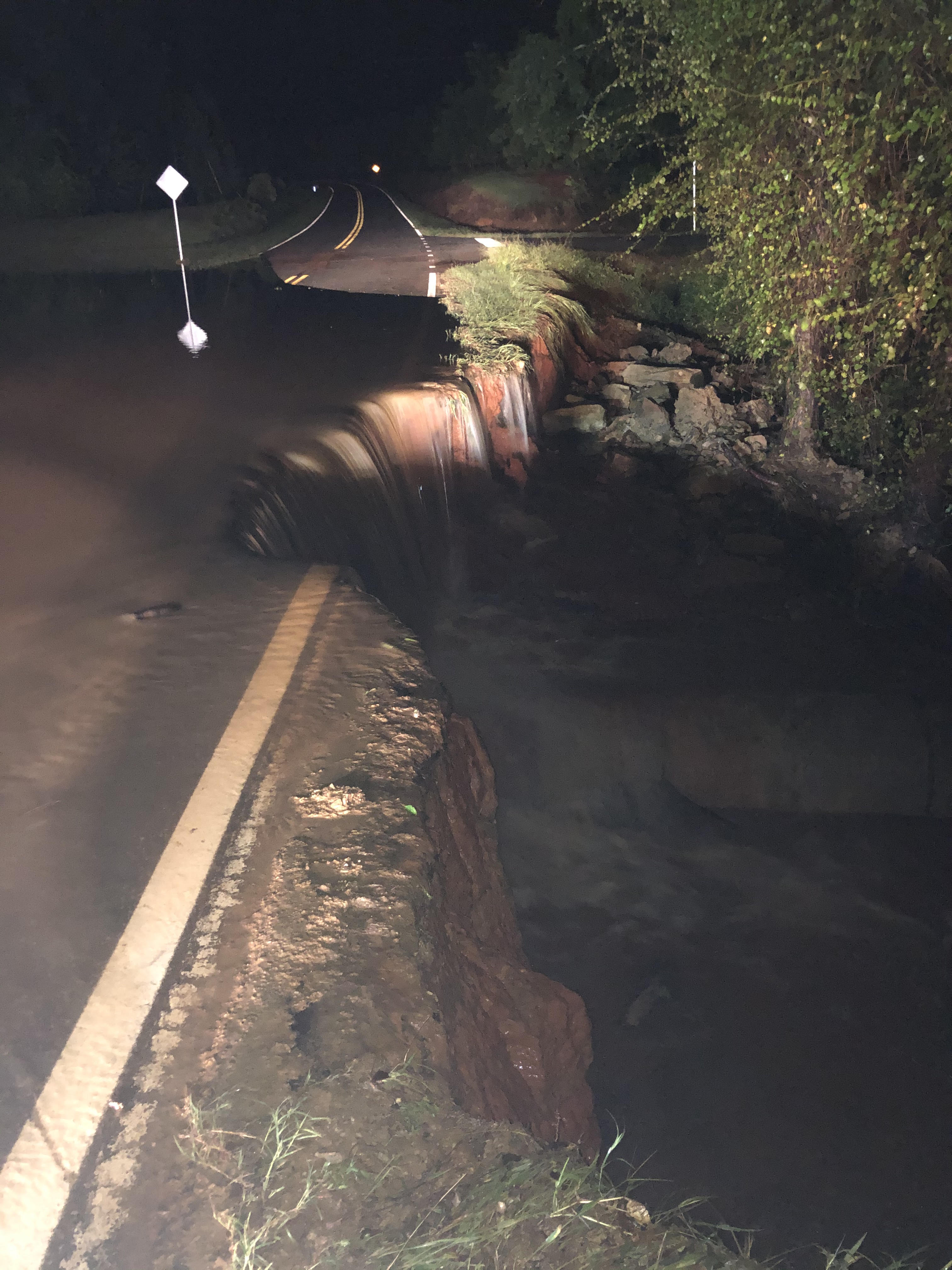

Spring Hill Church Road near Roberta was washed out by flash flooding.
Williamson Swamp Creek overflowed portions of SR-231 near Davisboro in Washington County.

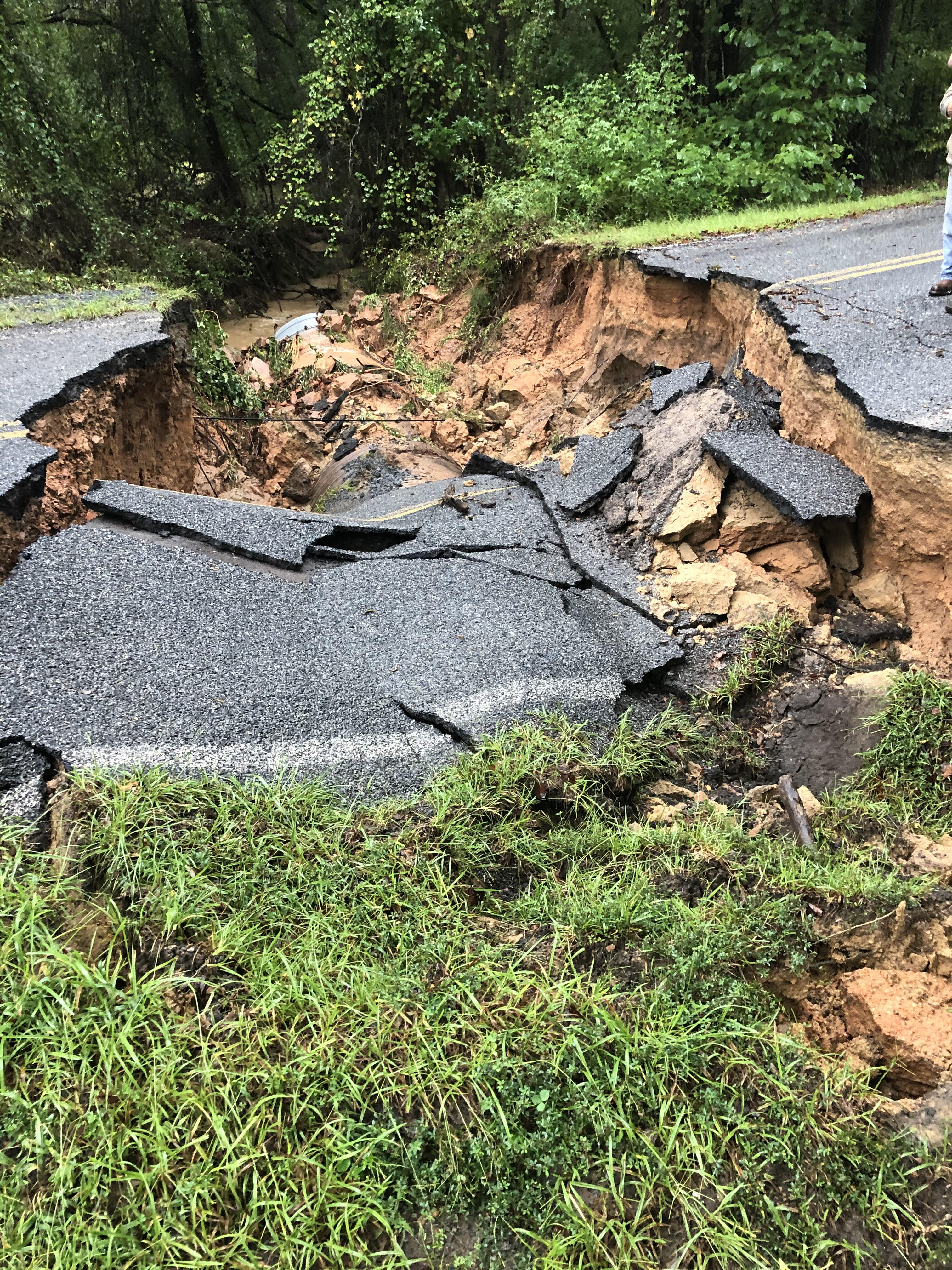
Part of SR-24 in Washington County collapsed as it was undermined by rapidly flowing water.
Taylor's Mill Road was washed out by an overflowing drainage pipe in Crawford County.
Gusty Winds

The strongest wind gusts in the local area were recorded in Columbus, where gusts peaked at 43 mph.

Wind gusts reached 39 mph at the Atlanta airport.

This large tree was downed onto a vehicle at the intersection of Mt. Vernon Road and Chamblee Dunwoody Road in Dunwoody. (courtesy - Dunwoody Police)

A tree was downed on Haynes Bridge Rd at Mansell Rd in Alpharetta. (courtesy - Alpharetta Police)
This tree was downed in Wilkes County. (courtesy - Wilkes County EMA)


