April 1, 2016 Severe Weather Event
This was no April Fool's, as several rounds of strong to severe storms tracked primariliy across central Georgia with the strongest occurring near the morning rush hour period. Development occurred within a warm sector of a developing low pressure system well ahead of the associated cold front. The environment was favorable for damaging winds and isolated tornadoes given the strong southwest jet across the southeast U.S. (seen in bottom 500mb map) providing enhanced bulk wind shear and also a pocket of strong low level shear across central Georgia supportive of rotation within storms (seen in bottom 0-1 km storm relative helicity map). Four tornadoes resulted with their surveyed damage details included below.
|
|
 |
|
| Surface map (8 am) | Upper level (500 mb) map (8 am) |
 |
| 0-1 km storm relative helicity (SRH) map (8 am) |
|
|
|
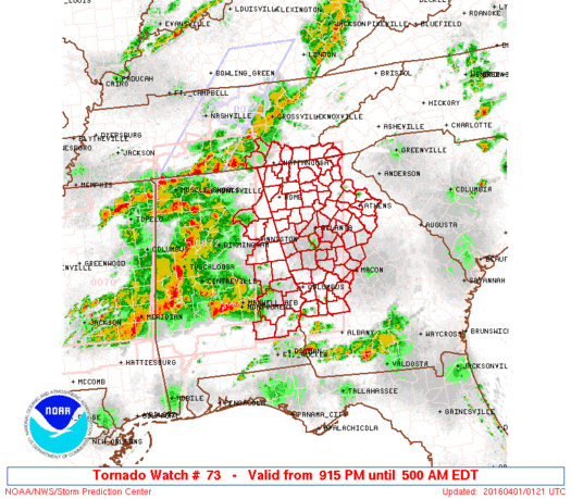
| Initial tornado watch from overnight March 31, 2016 into early morning April 1 | Subsequent tornado watch from April 1, 2016 |
|
|
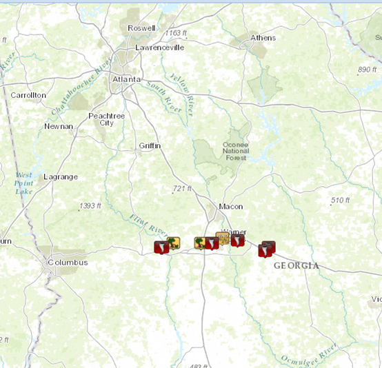
| Storm Reports from April 1, 2016 |
Taylor/Crawford Counties:
A weak tornado briefly touched down near the intersection of GA-Hwy 128 and Thomas Road...about 2.5 miles north of Reynolds in east-central Taylor County. The EF-0 tornado with maximum winds of around 80 mph mainly snapped or uprooted a few trees. A small shed was destroyed near a residence off Thomas road. The tornado did further damage just past the Taylor and Crawford County line before lifting. Aerial survey confirms the damage path (and pattern) consistent with the tightening circulation on radar. No further damage was seen east in Crawford county, but western Crawford county is mainly swamp/marsh-lands.
|
|
|
|
 |
| Numerous pine trees were blown down in a wooded area in Taylor County. | A number of trees were snapped or uprooted near the end of the track near the Flint River in western Crawford County. |
|
|
 |
| Reflectivity (7:05 AM EDT). | Velocity (7:05 AM EDT). |
Houston County:
A tornado touched down just northeast of Centerville in northern Houston County at approximately 7:42 am EDT Friday, April 1. The tornado initially took out some trees along Sentry Oaks Drive then strengthened quickly as it moved east across Napier Ave, Fisher St, and Carter Circle. It was in this narrow location where the tornado briefly peaked to EF-1 intensity with estimated maximum winds around 90 mph. Multiple large trees were either snapped or uprooted...some falling on residences. Actual structural damage was minor aside from where trees fell on homes. The weak tornado continued to track east- northeast causing sporadic damage in the form of snapped/uprooted trees between Watson Blvd and Green Street. The tornado crossed north Davis Drive with uprooted trees in a convergent pattern. A large oak tree was snapped at the intersection of Duke Ave and North Sixth Street.
Update: It has been confirmed based on new meteorological and physical data that the tornado did indeed cross the west side of Robins Air Force Base (AFB) near the Green Street gate/entrance. Large pieces of a metal roof from a maintenance hangar were stripped off along with several large branches snapped from pine trees around the hangar. This damage is in line with the damage that was seen along Duke Avenue just west of the base.
|
|
|
|
 |
| There was significant tree damage in the EF-1 portion of the tornado track in Warner Robins. | At Robins AFB, large pieces of a metal roof from a maintenance hangar were stripped off. |
|
|
 |
| Reflectivity (7:47 AM EDT). | Velocity (7:47 AM EDT). |
Twiggs County #1:
The tornado that moved across Warner Robbins and Centerville spun up one last time before dissapating in rural western Twiggs County. An NWS damage survey team found several trees snapped in a aline that extended northeast along and near Bullard Rd. which also corresponded with doppler radar indicated rotation at a few hundred feet off the ground. The tornado was weak and had no structures in its path. NWS survey teams followed the remnant circulation northeast to north of interstate 16 but could find no further evidence of damage.
|
|
|
|
 |
| A tree was snapped along this brief, weak tornado's path. | Another tree was snapped along this brief, weak tornado's path. |
|
|
 |
| Reflectivity (8:02 AM EDT). | Velocity (8:05 AM EDT). |
Twiggs/Wilkinson Counties (Allentown):
A brief tornado touched down in extreme eastern Twiggs County around 8:50 am EDT Friday, April 1. The tornado damaged two double wide manufactured homes...one significantly...with a majority of the roof uplifted and partial collapse of the exterior front wall. Trees surrounding the residences were snapped or uprooted. This damage is consistent with an EF-1 rating with max winds of around 95 mph. The tornado then continued northeast...crossing I-16...with about a 300-yard-wide swath of trees down on either side of the interstate. The tornado then tracked over a rural area before doing additional damage along Highway 112 (Main Street) about 1/2 mile southwest of the center of Allentown. Two trailers used for storage sustained significant damage with several trees uprooted. Just before lifting, the tornado snapped several trees in a very narrow path along and just west of US Hwy 80. No further damage was seen downstream.
|
|
|
|
 |
| This double-wide manufactured home sustained EF-1 damage from the tornado with much of the roof removed. | This residence also sustatined EF-1 tornado damage. |
|
|
 |
| Reflectivity (8:49 AM EDT). | Velocity (8:52 AM EDT). |