Remnants of Tropical Storm Fred Affect Georgia
August 17, 2021
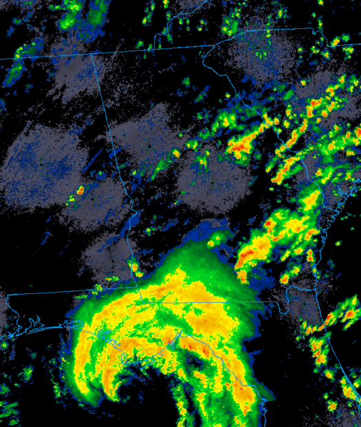
Tropical Storm Fred made landfall near Cape San Blas in the Florida panhandle as a tropical storm with sustained winds as high as 65 mph on the afternoon of August 16, 2021. Fred then quickly weakened as it moved inland across southeastern Alabama and into western Georgia by the early morning hours of August 17th. Fortunately, the weakening system allowed winds to diminish before reaching the NWS Atlanta forecast area, with peak gusts remaining largely below 40 mph locally.
As the weakening storm moved northward, tropical moisture overspread central and north Georgia, bringing widespread heavy rainfall. This heavy rainfall led to localized flooding issues through the day on August 17th. Additionally, as Georgia was situated on the active eastern side of the storm, seven tornadoes were spawned in the NWS Atlanta forecast area in convective cells in the outer bands from the predawn hours into the late morning. Damage was limited to EF-0 to EF-1 intensity, and no one was injured in these tornadoes.
As the remnants of Fred spun northward into Middle and North Georgia, several rotating thunderstorm cells were noted in the outer convective rain bands of the system. These cells went on to produce seven tornadoes in the NWS Atlanta forecast area during the morning hours of August 17th. All of the tornadoes were in the EF-0 to EF-1 intensity range on the Enhanced Fujita Scale. Click on a tornado below to see more detailed survey information. (Tornadoes are arranged by time of occurrence from earliest to latest.)
Preliminary Survey Information:
(click Location for Detailed Survey)
| Location of Tornado |
EF-Scale Rating |
Fatalities/ Injuries |
Damage Path Length/Max Width | Start Point/ Time |
End Point/ Time |
|
|
EF-1 95 mph |
0 |
1.24 miles long 325 yards wide |
1 ENE Americus 32.0775 / -84.2087 1:25 AM EDT |
2 NNE Americus 32.0930 / -84.2192 1:27 AM EDT |
|
EF-0 85 mph |
0 |
3.36 miles long 150 yards wide |
3 WSW Rocky Mount 33.1523 / -84.7178 4:34 AM EDT |
2 E Lone Oak
33.1688 / -84.7724 4:39 AM EDT |
|
|
EF-0 80 mph |
0 |
2.6 miles long 150 yards wide |
2 N District Path 32.6495 / -83.3672 5:47 AM EDT |
1 E District Path 32.6123 / -83.3609 5:53 AM EDT |
|
|
EF-1 90 mph |
0 |
5.6 miles long 100 yards wide |
2 N Carey 33.5824 / -83.2554 6:24 AM EDT |
2 NNE Greshamville 33.6539 / -83.2991 6:32 AM EDT |
|
|
EF-0 75 mph |
0 |
1.86 miles long 150 yards wide |
4 ENE Greenberry Crossroads 32.9617 / -83.3750 6:27 AM EDT |
4 SW Coopers 32.9429 / -83.3521 6:31 AM EDT |
|
|
|
EF-1 100 mph |
0 |
5.97 miles long 150 yards wide |
3 WNW Danielsville 34.1387 / -83.2653 8:20 AM EDT |
3 W Ila 34.1880 / -83.3505 8:29 AM EDT |
| Banks County |
EF-1 90 mph |
0 |
5.7 miles long 100 yards wide |
4 E Homer 34.3330 / -83.4161 10:24 AM EDT |
2 SW Pinefield Crossroads 34.4025 / -83.4696 10:31 AM EDT |
Abundant tropical moisture associated with Fred led to widespread rainfall amounts of 2 to 4 inches across most of the forecast area, and locally higher rainfall totals in excess of 6 inches were recorded in a few areas. While most areas avoided significant flooding from this event, localized flooding issues did arise in a number of locations across the area. Some roadways were temporarily flooded, causing problems with the morning commute. A few roads were washed out in areas where the heaviest rainfall fell. Additionally, a number of local waterways reached flood stage while others reported significant hydrological impacts.
|
|
| Rainfall totals reach 2-4" in many areas with localized amounts over 6". |
 |
|
| Some of the more significant flooding issues occurred in Helen, GA where a number of streets were flooded. | The Chattahoochee River in Helen rose to cover some riverside patios.(courtesy Stephanie Hill) |
 |
|
Some of the heaviest rainfall fell during the morning commute. Clogged storm drains led to some brief nuisance road flooding in parts of metro Atlanta, including here on I-85 in Gwinnett County. (courtesy WSB-TV) |
Notable Hydrographs:
These hydrographs show several of the local waterways that reached minor flood stage during and after the heavy rainfall from the remnants of Fred.
Click the images to enlarge and the "Esc" key to minimize.


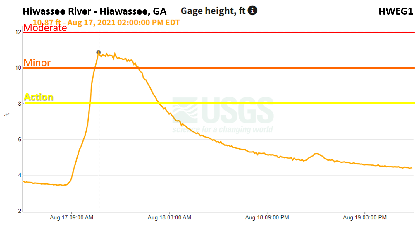


Charts courtesy of USGS.


