| Previous Month | Next Month |
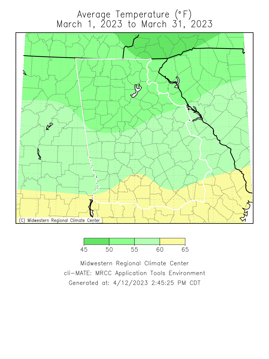
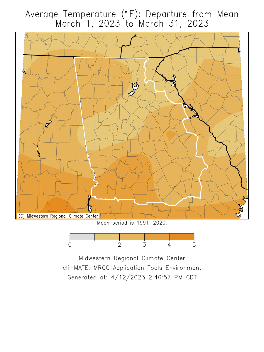
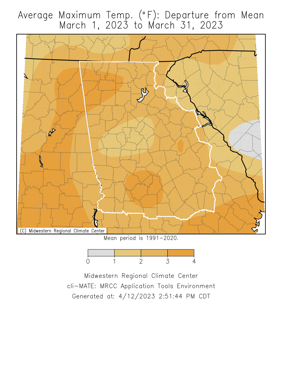
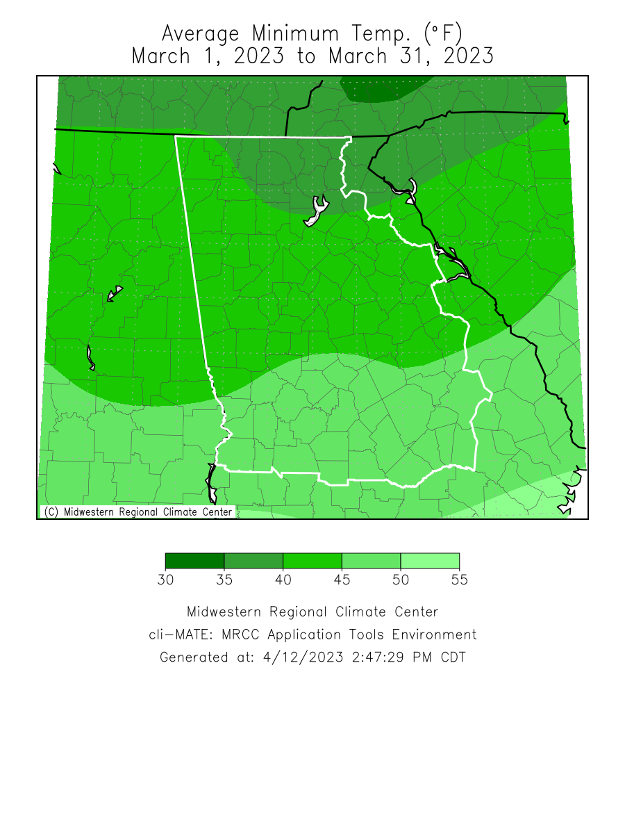
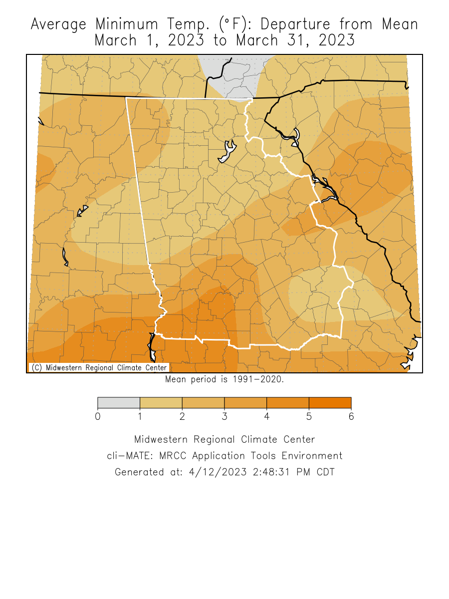
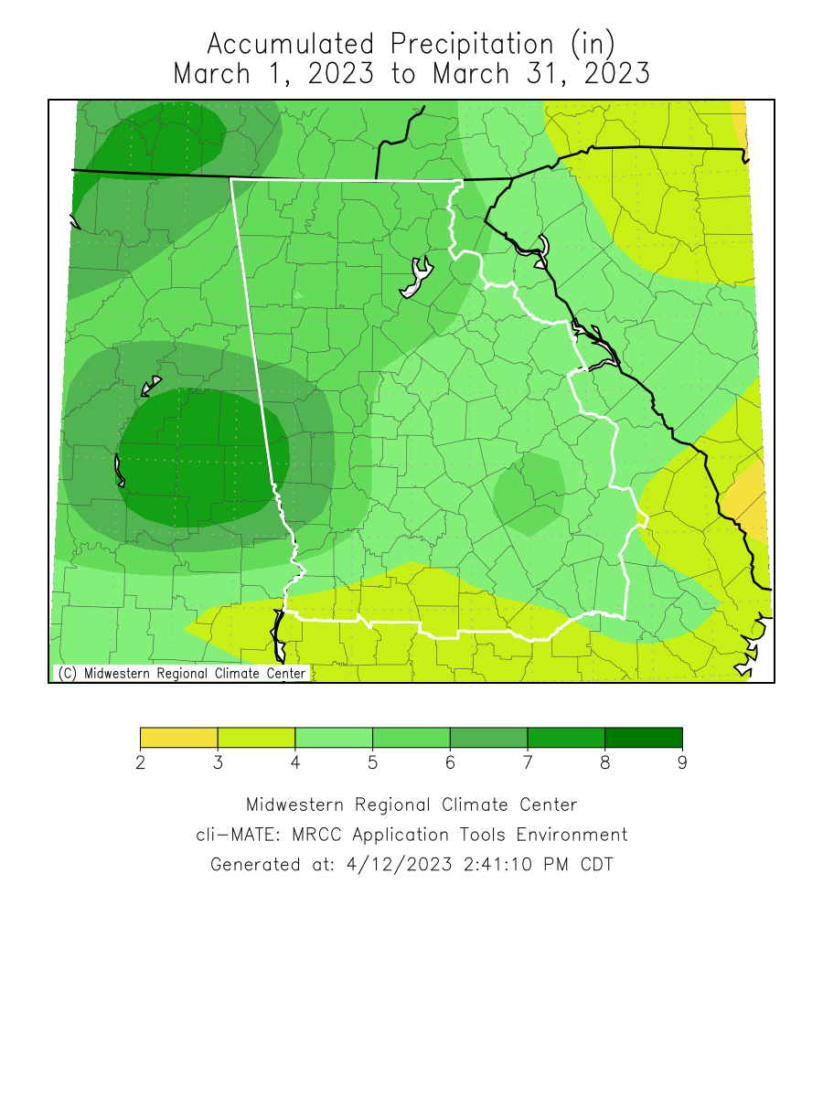
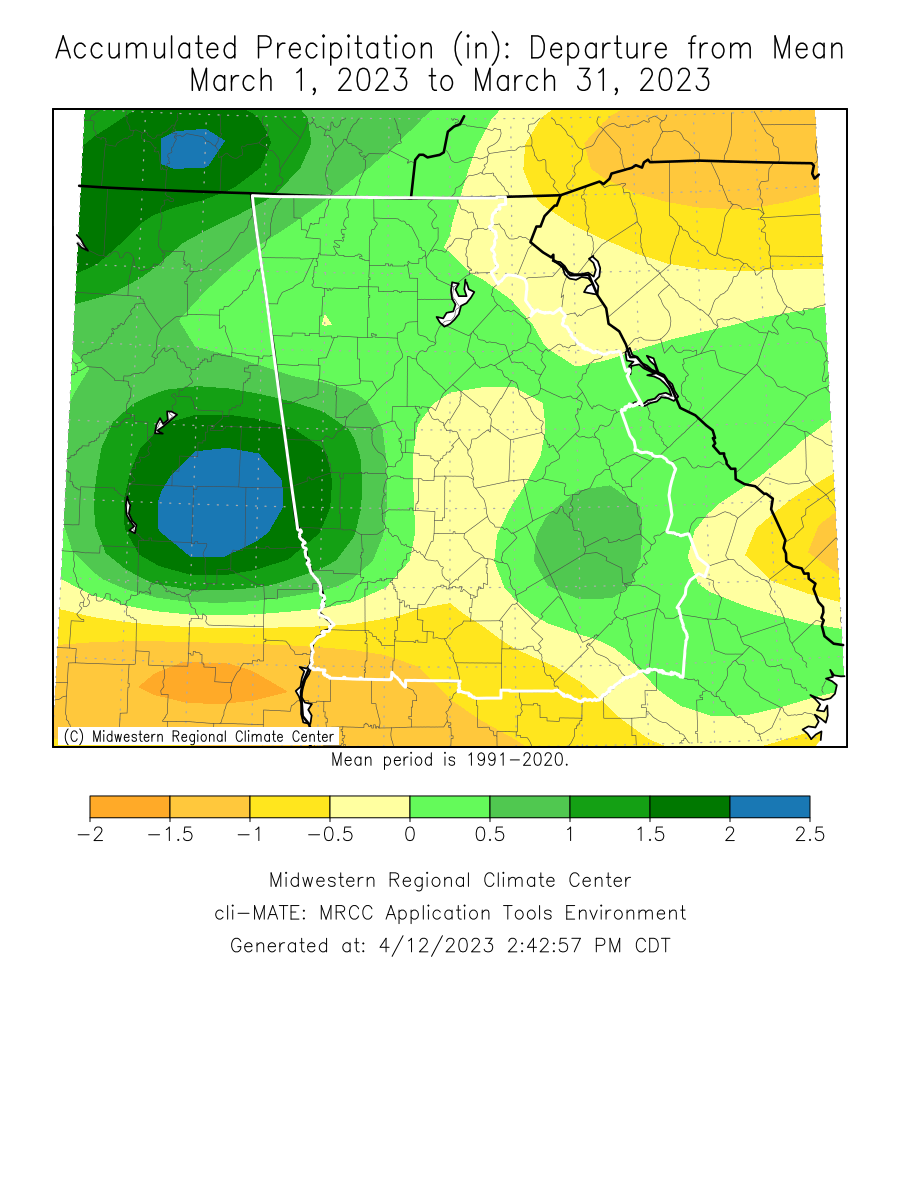
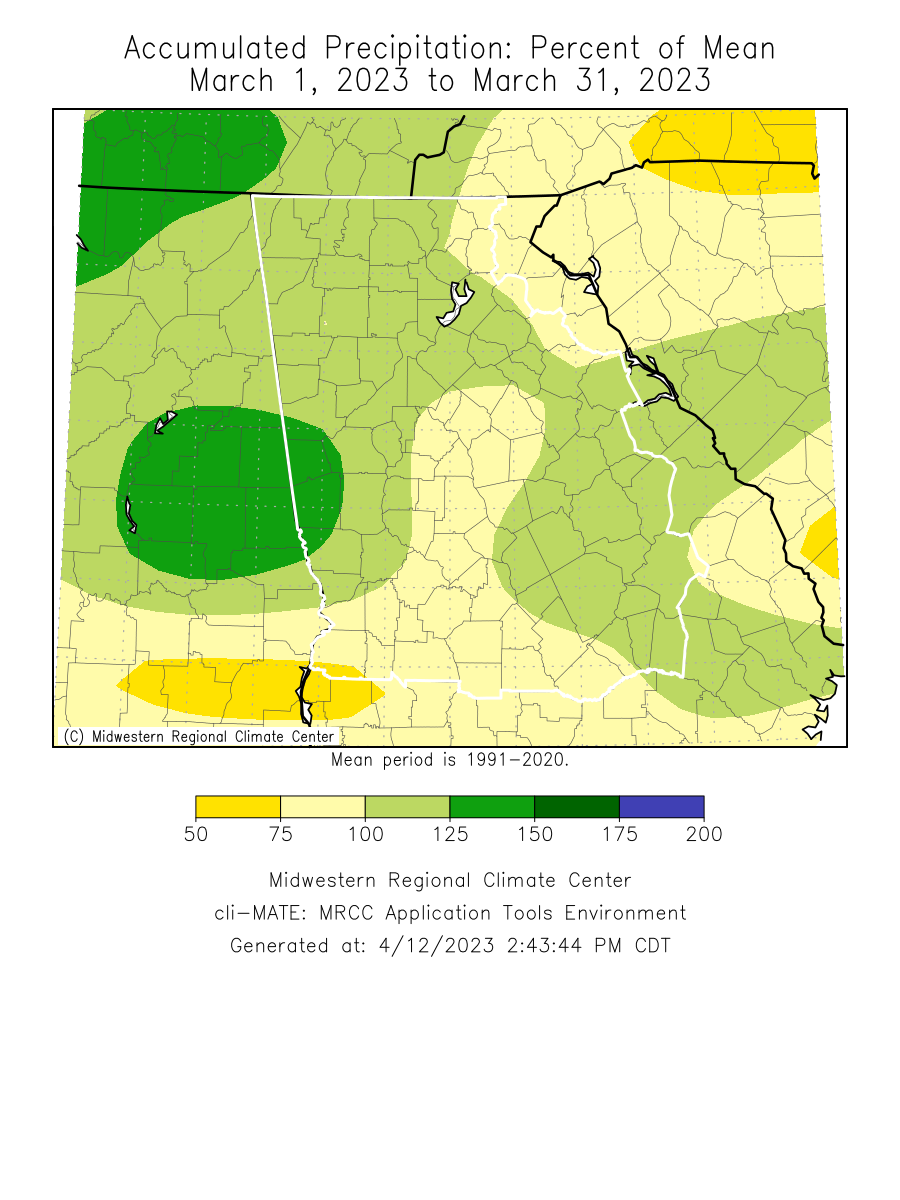
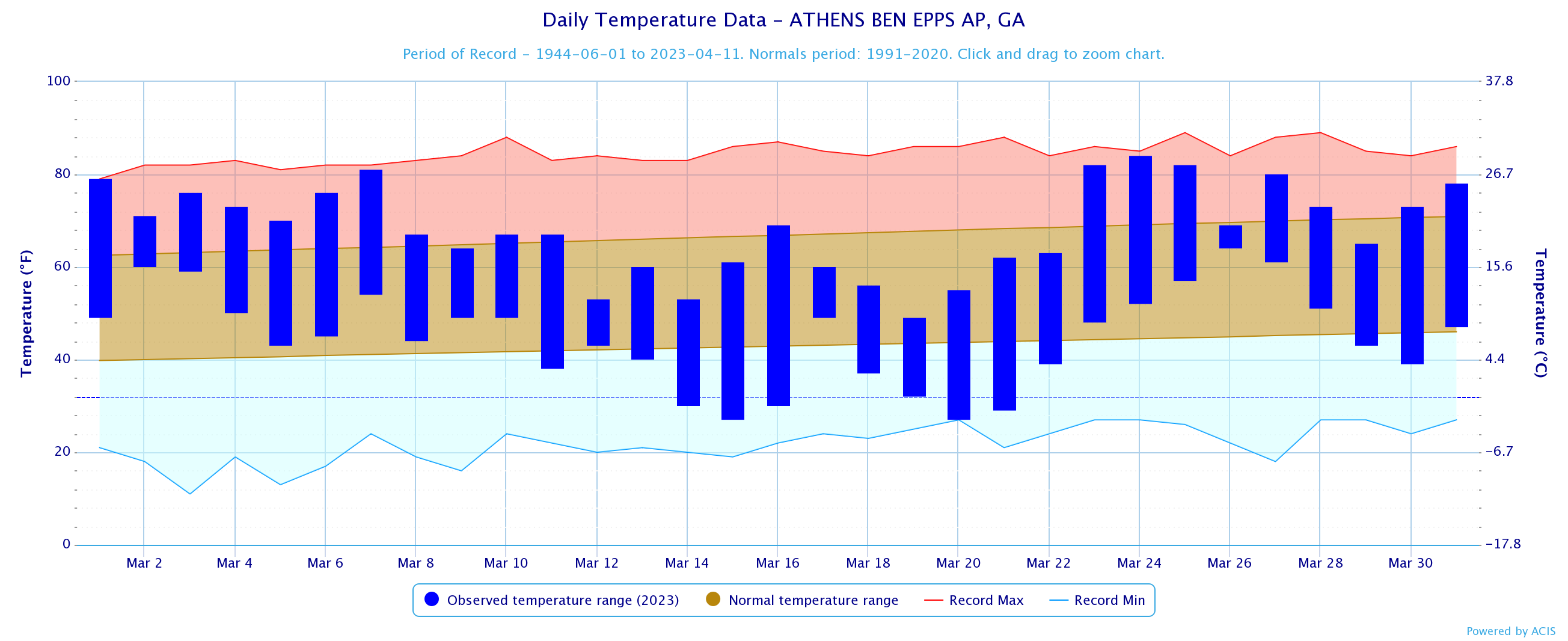
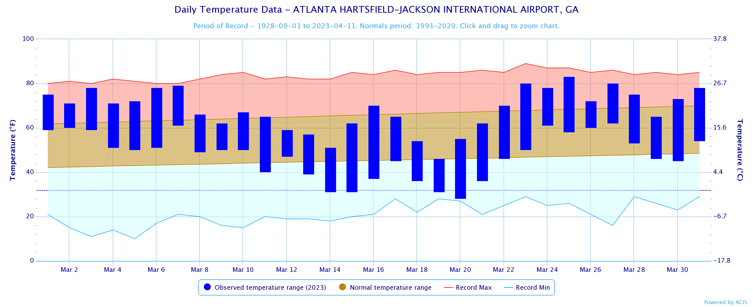
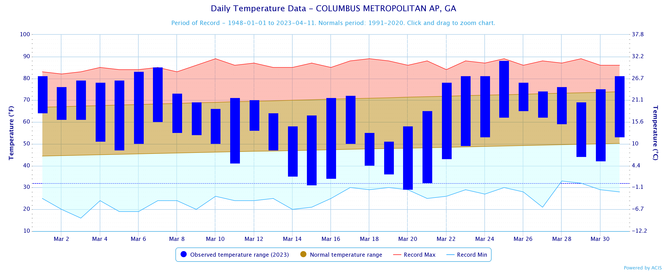
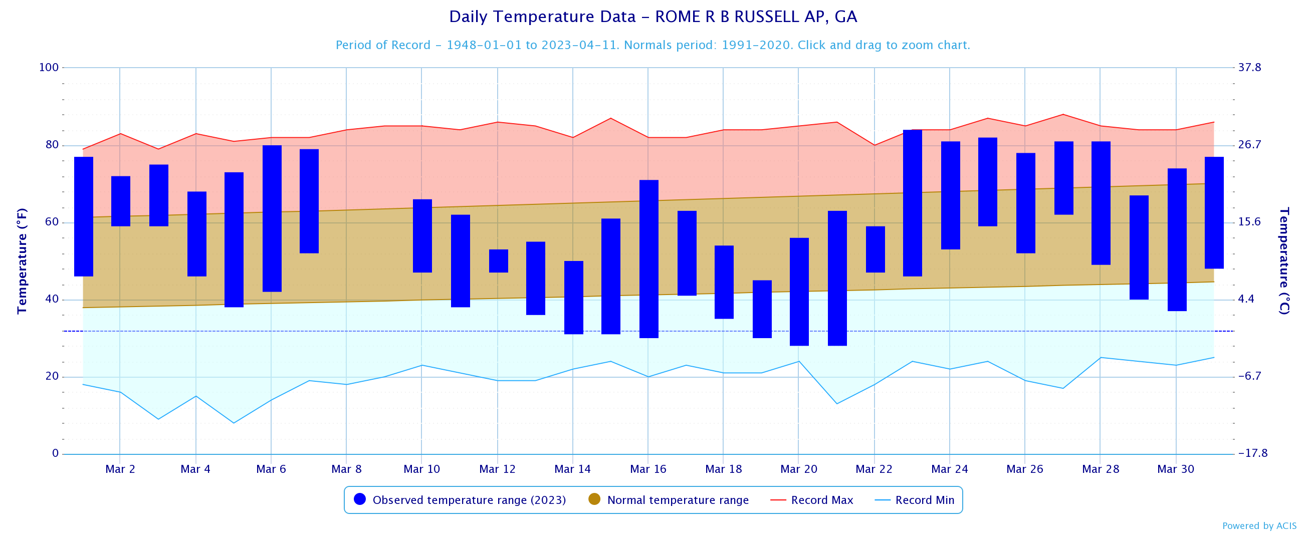
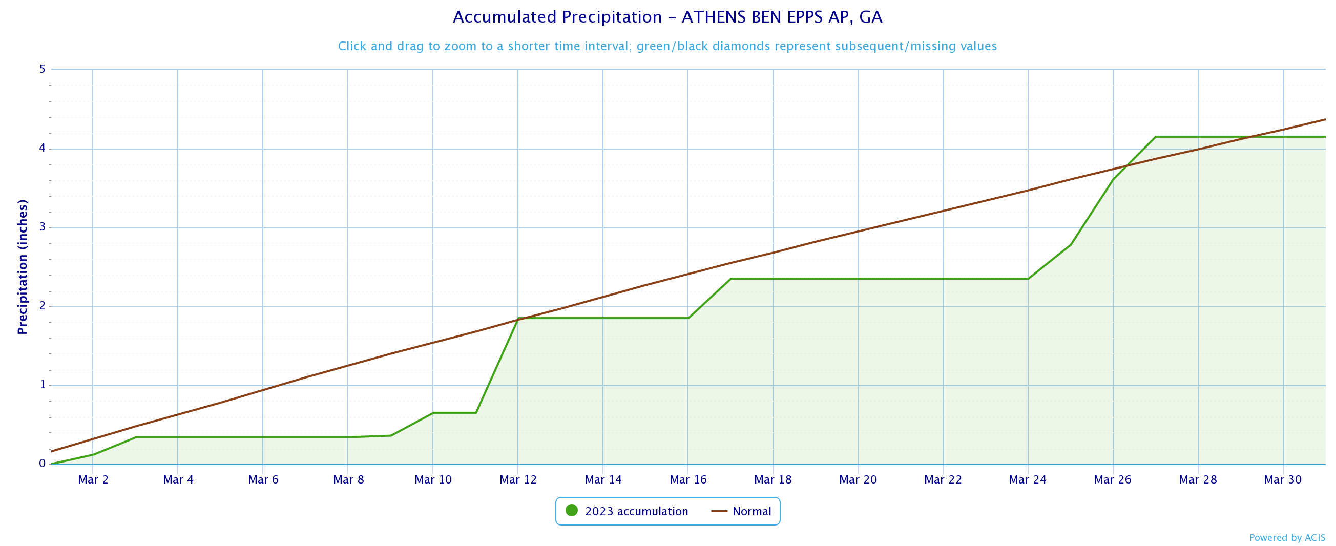
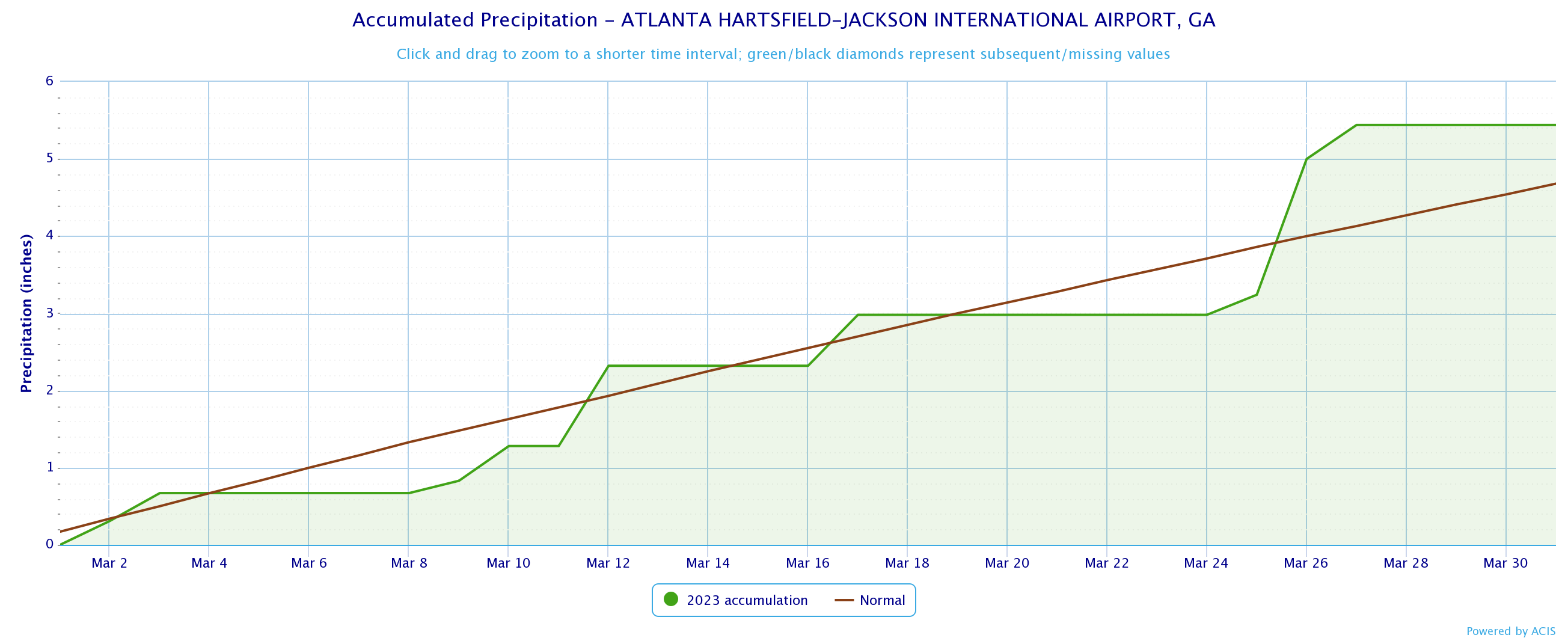
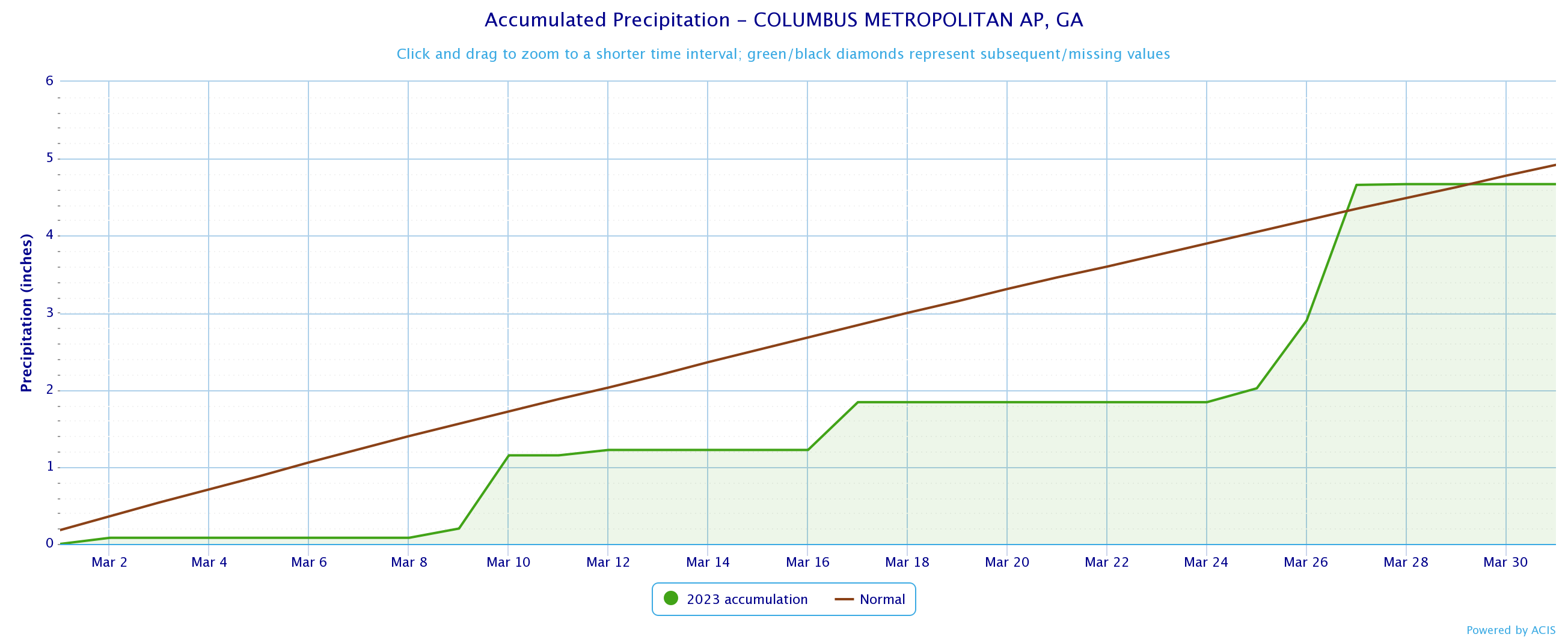
Temperatures through the month of March were 2 to 3 degrees above normal. Precipitation through the month of March was around generally within 1 inch of normal.
|
March 2023 Climate Averages
|
|||
|
Climate Site
|
March Temp (°F)
|
Average Temp
|
Departure from normal
|
|
Athens
|
56.5
|
54.9
|
1.6
|
|
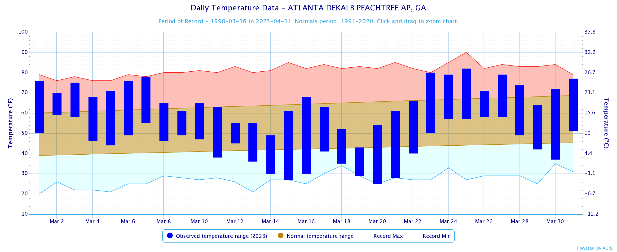
Atlanta
|
58.0
|
55.6
|
2.4
|
|
Columbus
|
60.7
|
58.9
|
1.8
|
|
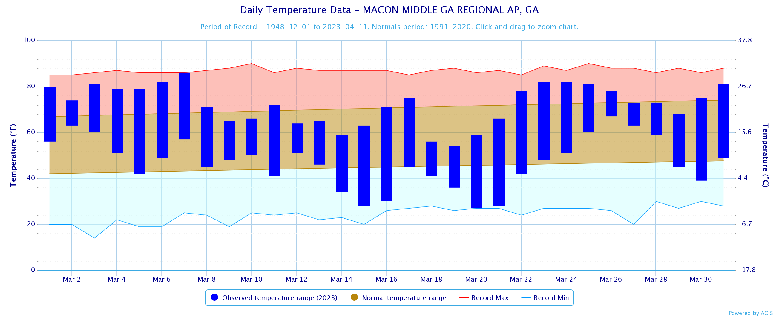
Macon
|
59.5
|
57.7
|
1.8
|
|
Dekalb Peachtree Arpt
|
55.5
|
53.3
|
2.2
|
|
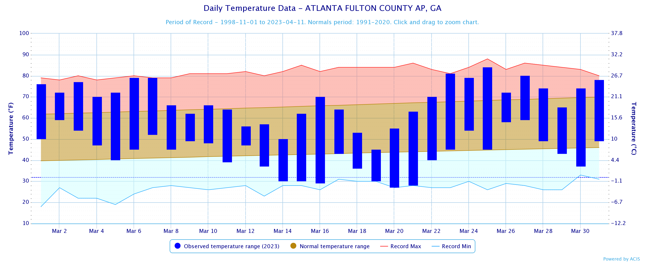
Fulton Co Arpt
|
55.8
|
54.4
|
1.4
|
|
Gainesville
|
56.3
|
53.0
|
3.3
|
|
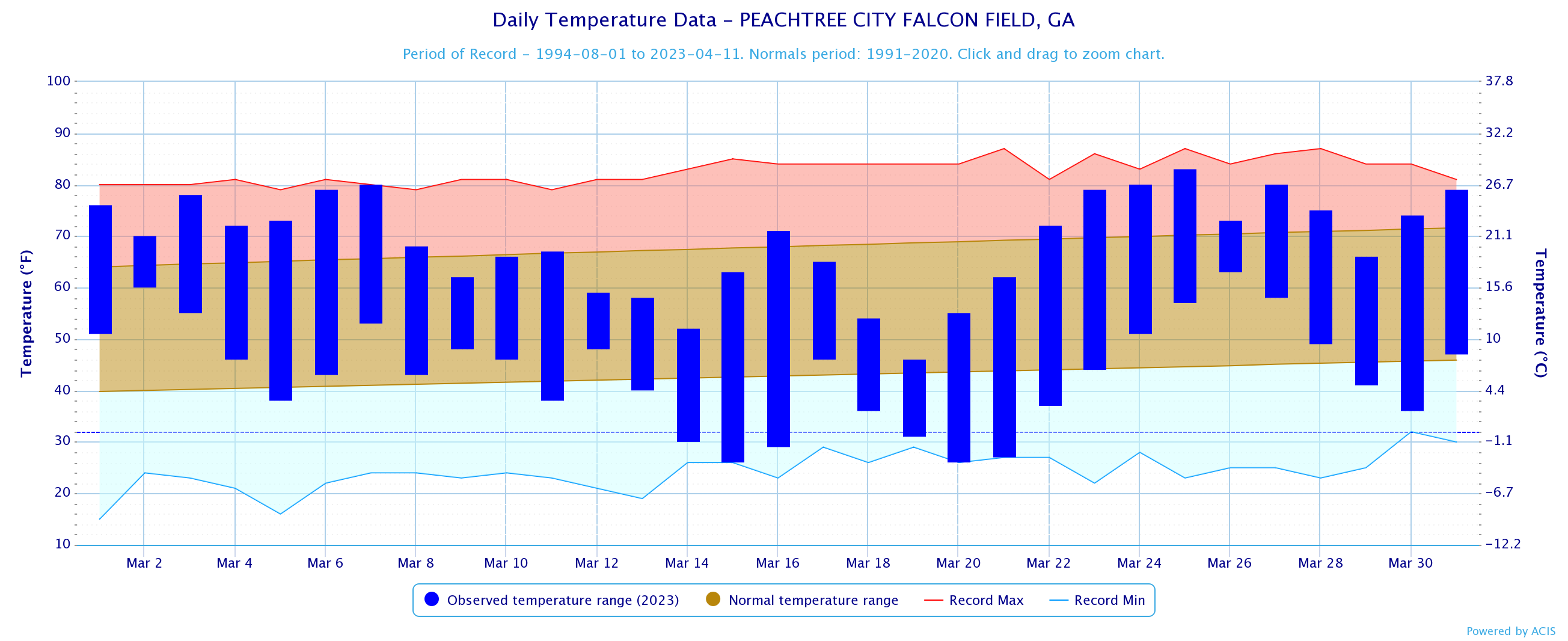
Peachtree City
|
56.1
|
54.2
|
1.9
|
|
Rome
|
55.8
|
53.4
|
2.4
|
|
March 2023 Temperature Climate Statistics
|
||||
|
Climate Site |
Maximum Temperature |
Max T Date |
Minimum Temperature
|
Min T Date
|
|
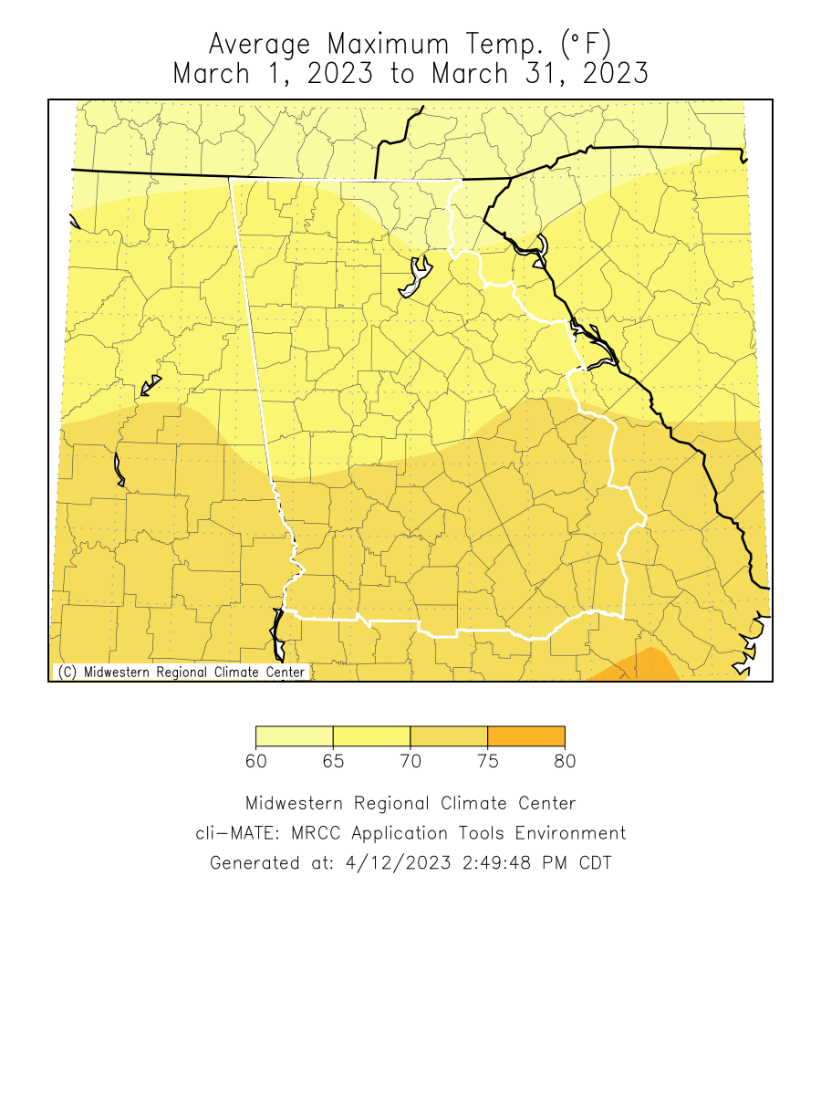
Athens
|
84
|
3/24
|
27
|
3/15, 20
|
|
Atlanta
|
83
|
3/25
|
28
|
3/20
|
|
Columbus
|
88
|
3/25
|
29
|
3/20
|
|
Macon
|
86*
|
3/7
|
27
|
3/20
|
|
Dekalb Peachtree Arpt
|
82
|
3/25
|
25
|
3/20
|
|
Fulton Co Arpt
|
84
|
3/25
|
27
|
3/20
|
|
Gainesville
|
82
|
3/24
|
29
|
3/15, 19
|
|
Peachtree City
|
83
|
3/25
|
26
|
3/15, 20
|
|
Rome
|
84
|
3/23
|
28
|
3/20, 21
|
*Indicates a daily record was set
|
March 2023 Precipitation Climate Statistics
|
|||
|
Climate Site |
Total Precipitation |
Average Precipitation
|
DFN (Departure From Normal)
|
|
Athens
|
4.15
|
4.37
|
-0.22
|
|
Atlanta
|
5.44
|
4.68
|
0.76
|
|
Columbus
|
4.67
|
4.92
|
-0.25
|
|
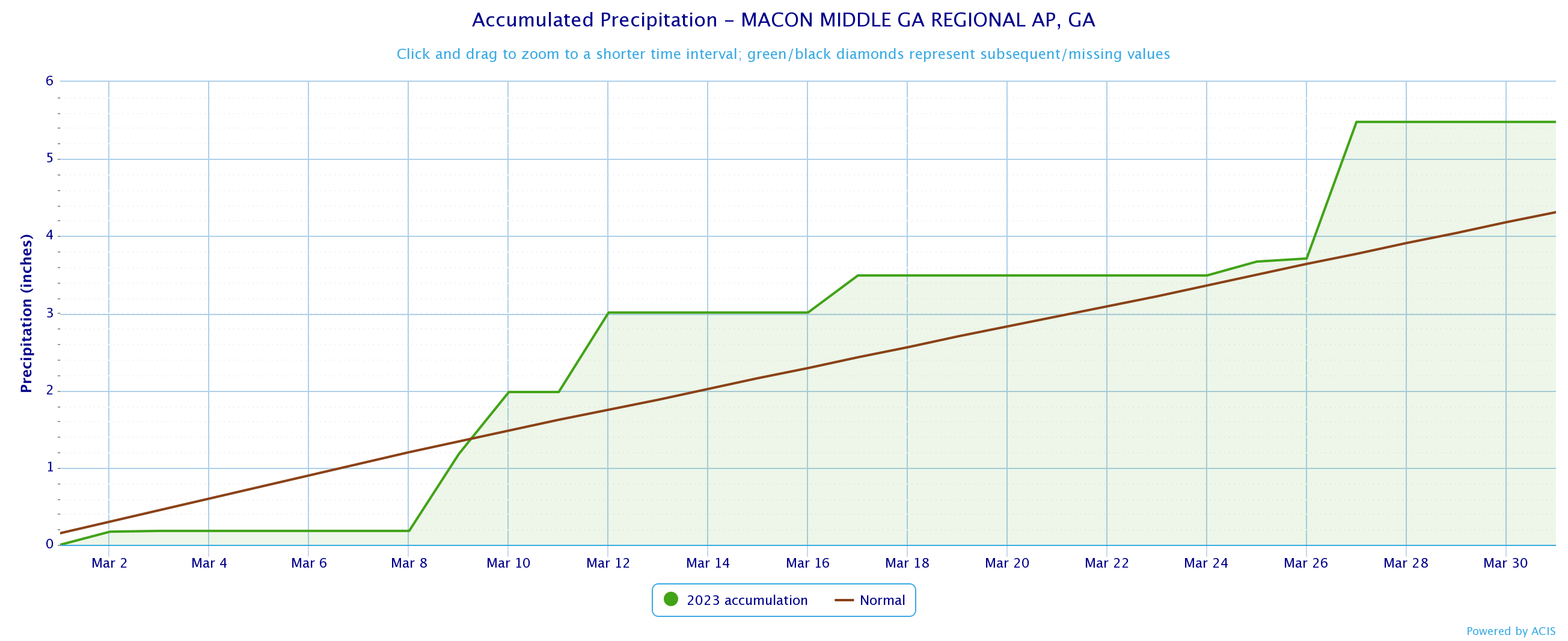
Macon
|
4.04
|
4.31
|
-0.27
|
|
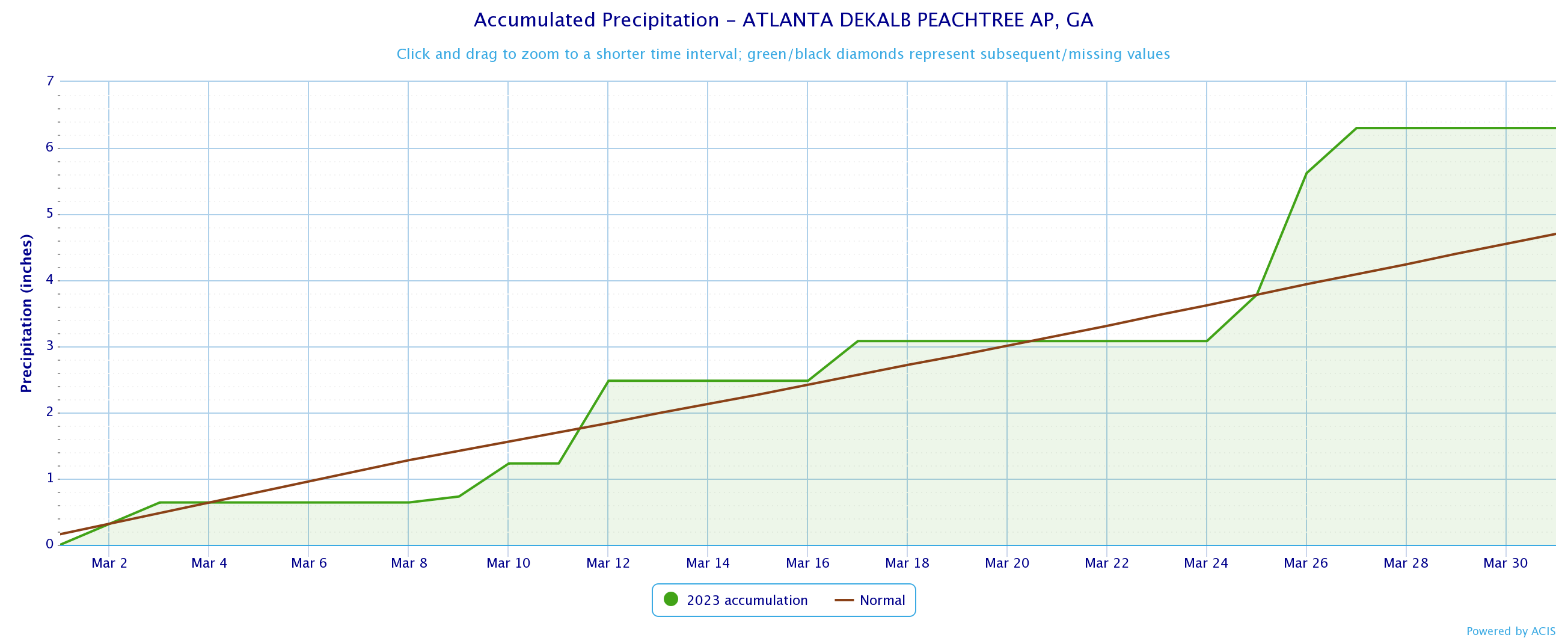
Dekalb Peachtree Arpt
|
6.10
|
4.50
|
4.60
|
|
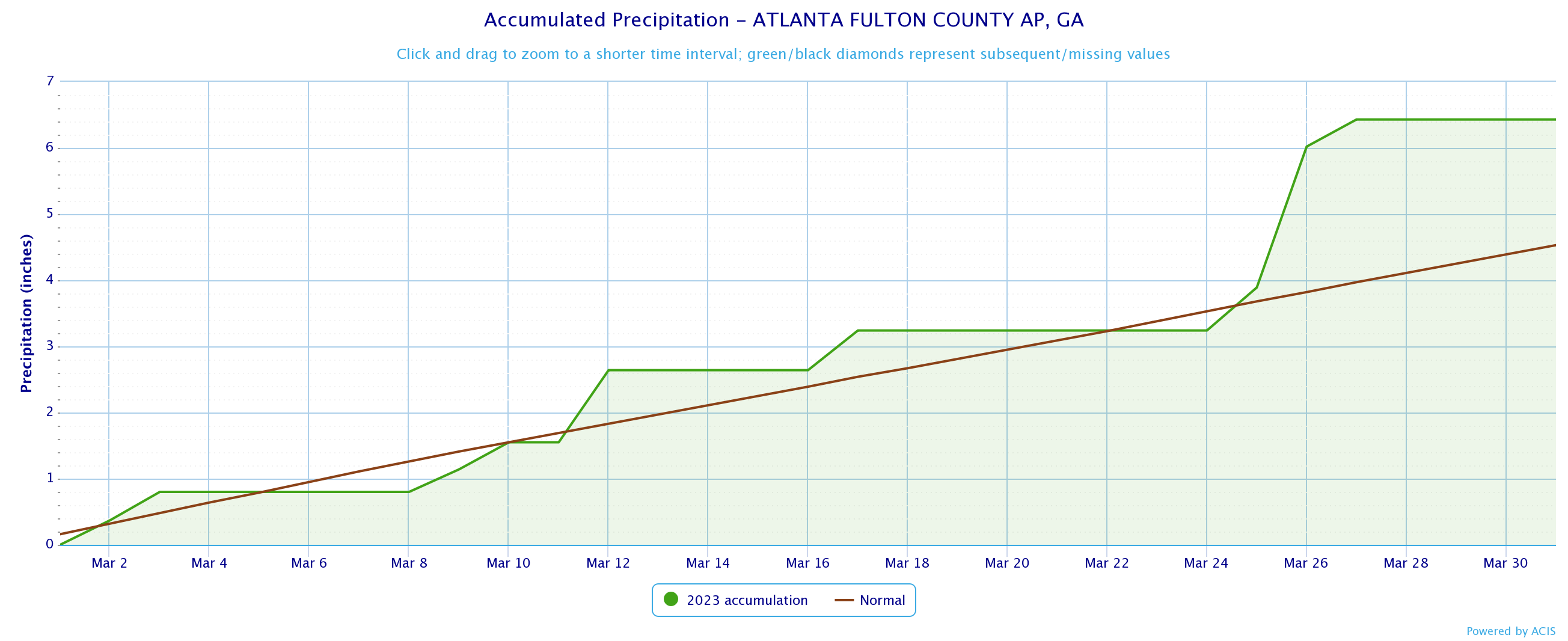
Fulton County Arpt
|
6.43
|
4.53
|
1.90
|
|
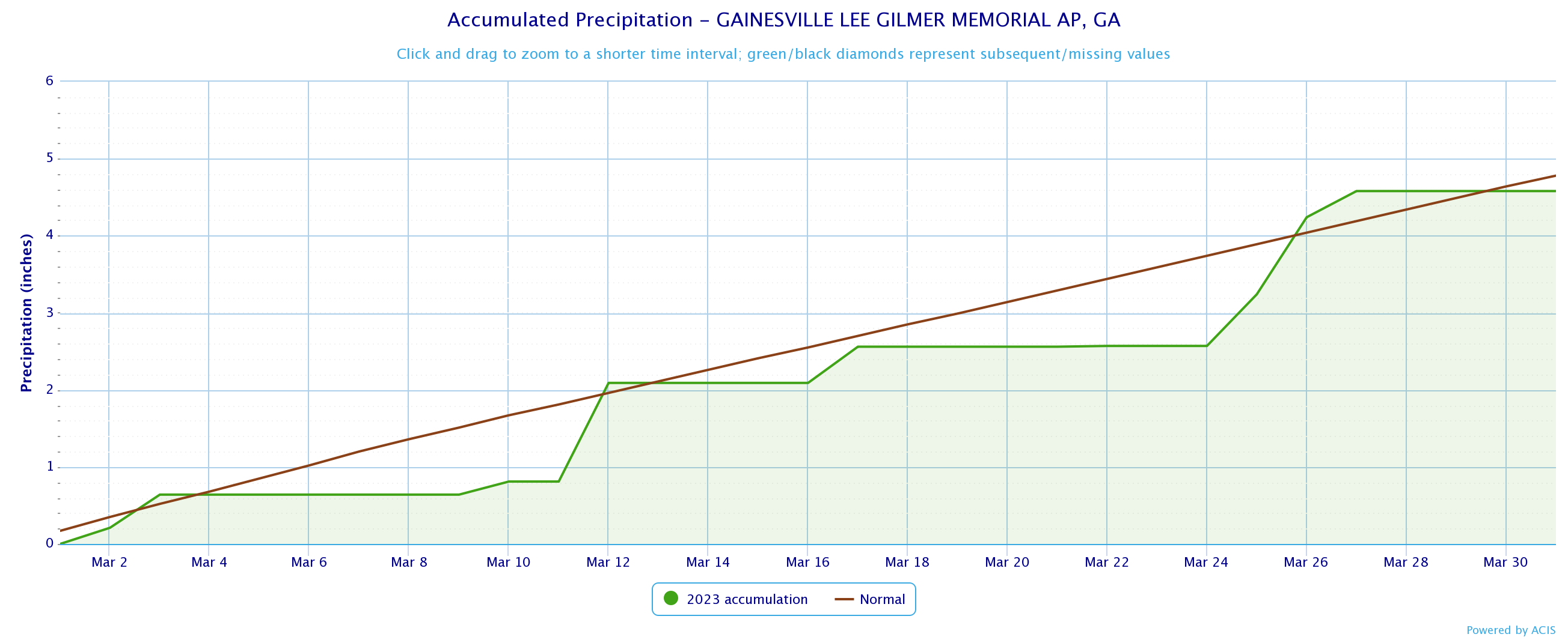
Gainesville
|
4.58
|
4.78
|
-0.20
|
|
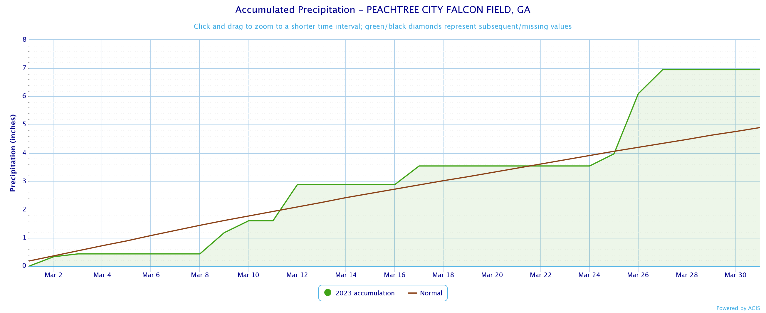
Peachtree City
|
6.95
|
4.90
|
2.05
|
|
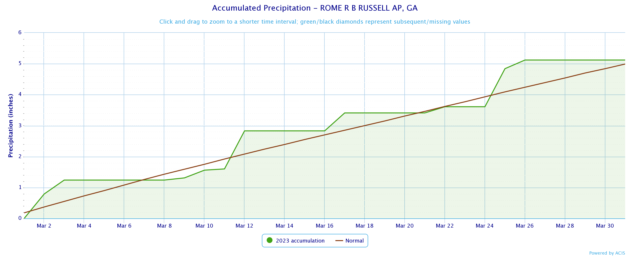
Rome
|
5.12
|
4.99
|
0.13
|
|
March 2023 Precipitation Climate Statistics
|
||||
|
Climate Site |
Maximum Daily Precip (in inches) |
Max P Date |
||
|
Athens
|
1.29
|
3/26
|
||
|
Atlanta
|
2.09
|
3/26
|
||
|
Columbus
|
2.64
|
3/26
|
||
|
Macon
|
2.51
|
3/26
|
||
|
Dekalb Peachtree Arpt
|
2.53
|
3/26
|
||
|
Fulton Co Arpt
|
2.53
|
3/26
|
||
|
Gainesville
|
1.34
|
3/26
|
||
|
Peachtree City
|
1.47
|
3/9
|
||
|
Rome
|
1.27
|
3/11
|
||
*Indicates a daily record was set
Data prepared by NWS Peachtree City/Atlanta
Temperature Maps |
Precipitation Maps
|
Temperature Graphs
|
Precipitation Graphs |
|
March 2023 Climate Records
|
|||
|
Date
|
Type
|
Location
|
Records set over a 24 hour period
|
|
3/07
|
High T
|
Macon |
A daily record high Temperature of 86° breaks the old record of 84 set in 1956.
|
Note: Many of these events are still in the process of being studied and investigated. Future edits to this page may include additional information that was not included in the initial Public Information Statement. Thank you for your patience.
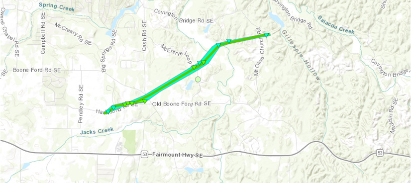
Gordon County Tornado (March 3):
An EF1 tornado touched down on the afternoon of March 3, 2023 as a line of storms moved through the region. The tornado first touched down along Hammond Rd, where several trees were snapped or uprooted. The tornado continued to the ENE, causing damage to several homes along Langston Rd SE (including siding and roof damage) as well as destroying an outbuilding. The tornado continued ENE to the north of Hammond Rd, snapping and uprooting trees, and crossed Cash Rd into a largely wooded area until it reached McEntyre Loop. Several trees and powerlines were snapped and a barn was nearly destroyed. The tornado continued to the ENE, crossing Creek Ridge Dr and uprooting a few trees in the area. As the tornado crossed Mt. Olive Rd, several trees were uprooted on a hillside to the east of the road. These were the last damage indicators found, thus the tornado is presumed to have lifted shortly thereafter and in the area of Young-Wright Lake.
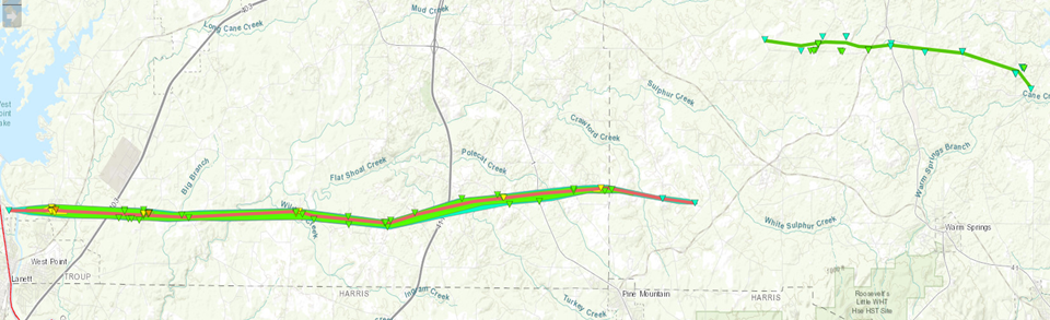
Troup County Tornado (March 26):
This long track tornado first touched down just inside the Alabama-Georgia state line, just west of the Chattahoochee River along State Line Rd, where several trees were snapped and noted as EF0 damage. Over the course of the next 1.25 miles, the tornado rapidly intensified to EF3 strength as it moved into North West Point. West Point Rd (Hwy 29) sustained the most significant damage with several homes completely leveled and many others sustaining major damages. Other homes with major damage nearby also suggested a mid-range EF3 tornado within the core of the strongest winds. The area of most significant damage was located between West Point Rd, 1st Ave and Samples Rd.
Significant damage was also noted along Ann Murphy Rd to the west of Hwy 29. The tornado continued east across a mostly wooded area until it reached Kia Pkwy and I-85 where a large swath of trees were snapped and uprooted. The tornado continued east along Lower Lovelace Rd, crossing Johns Rd and Billings Rd, causing up to EF2 damage to several structures and many trees. Three homes were nearly destroyed along Shoemaker Rd as the tornado passed through. The tornado crossed Adams Rd and Jarrell Hogg Rd, causing EF1 damage to several homes and outbuildings as well as snapping and uprooting many trees. The tornado crossed Whitesville Rd near the intersection of Ely Callaway Rd, causing EF1 and EF2 damage to several homes and snapping and uprooting many trees.
The storm continued east crossing Bright Star Church Rd, Salem Farm Rd, and Flat Shoals Church Rd, snapping and uprooting many trees and causing mostly EF0 to EF1 damage to homes along each of those roads. The tornado continued east snapping trees along White Rd before crossing I-185 snapping trees along both sides of the interstate. As it crossed Oak Grove Rd, EF1 to EF2 damage was noted to both trees and most notably the Pine Mountain Wild Animal Safari where several tigers had escaped as a result of the tornado. The tornado continued east, crossing Hamilton Rd (Hwy 27) and Old Chipley Rd, snapping and uprooting many trees noted as mostly EF1 damage. As the tornado crossed into the Cherokee Resort club near the Troup County line, more than 40+ cabins sustained damage with several cabins destroyed. The tornado damage in some sections of the resort was rated as EF2.
The tornado continued into Meriwether County crossing Dallas Mill Rd where it began to weaken rapidly. The last location of damage was located along Robert Williams Rd, where a couple snapped trees were found. According to Troup County EMA, 146 total homes were affected, 23 were destroyed, 26 sustained major damage and 41 sustained minor damage. Additionally, several businesses were affected.
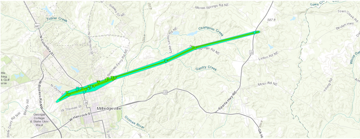
Baldwin County Tornado (March 26):
This tornado spun up in an area west of North Glynn St and West Charlton St, snapping and uprooting trees. The tornado quickly intensified to EF1 as it hit the Oconee Regional Medical Center. Several windows were blown out, much of the roof of the covered walkway on the west entrance collapsed, and the roof of the atrium and the main building sustained some damage. The tornado continued east, snapping trees across a railroad track and damaging a roof of several industrial buildings to the south of MLK Jr. Dr. Several homes were damaged along Walton St by fallen trees and a large advertising sign was blown down along Columbus St as the tornado continued ENE, paralleling MLK JR Dr and W. Mitchell St. Several homes along W. Mitchell, Fraleys Alley, and N. Wilkinson St sustained EF0 and EF1 damage and several homes had fallen trees on them.
A small retail complex along N. Wilkinson St sustained damage to its facade and had windows blown out. The tornado crossed MLK Jr Dr at the intersection of N. Jefferson St, where it hit Northside Baptist Church. One of the buildings' back wall was partially blown out, an HVAC unit was blown into the parking lot, and the main building sustained roof and siding damage. The storm continued ENE, crossing Orchard Hill Rd and striking the Baldwin County EOC where part of a roof structure was blown off and several trees were downed. It then moved across an industrial area with several large warehouses. Several of the warehouses had roof material blown off and several walls were blown out, including a large brick wall. A large trailer was picked up from the parking lot and thrown into one of the warehouses and several 18-wheeler trailers were blown over. The tornado continued ENE crossing the river and snapping and uprooting trees along Summit Rd and Lake Laurel Rd. As the tornado crossed Black Springs Road, a home sustained moderate roof damage as the carport was pulled away from the home. Numerous trees were snapped and uprooted in and around that area. The tornado quickly weakened as it crossed through a wooded area and Champions Creek. The tornado lifted shortly after crossing Sparta Hwy where a couple trees were uprooted.
Flash Flooding in Central Georgia (March 26-27):
To be released when information is compiled and study completed.
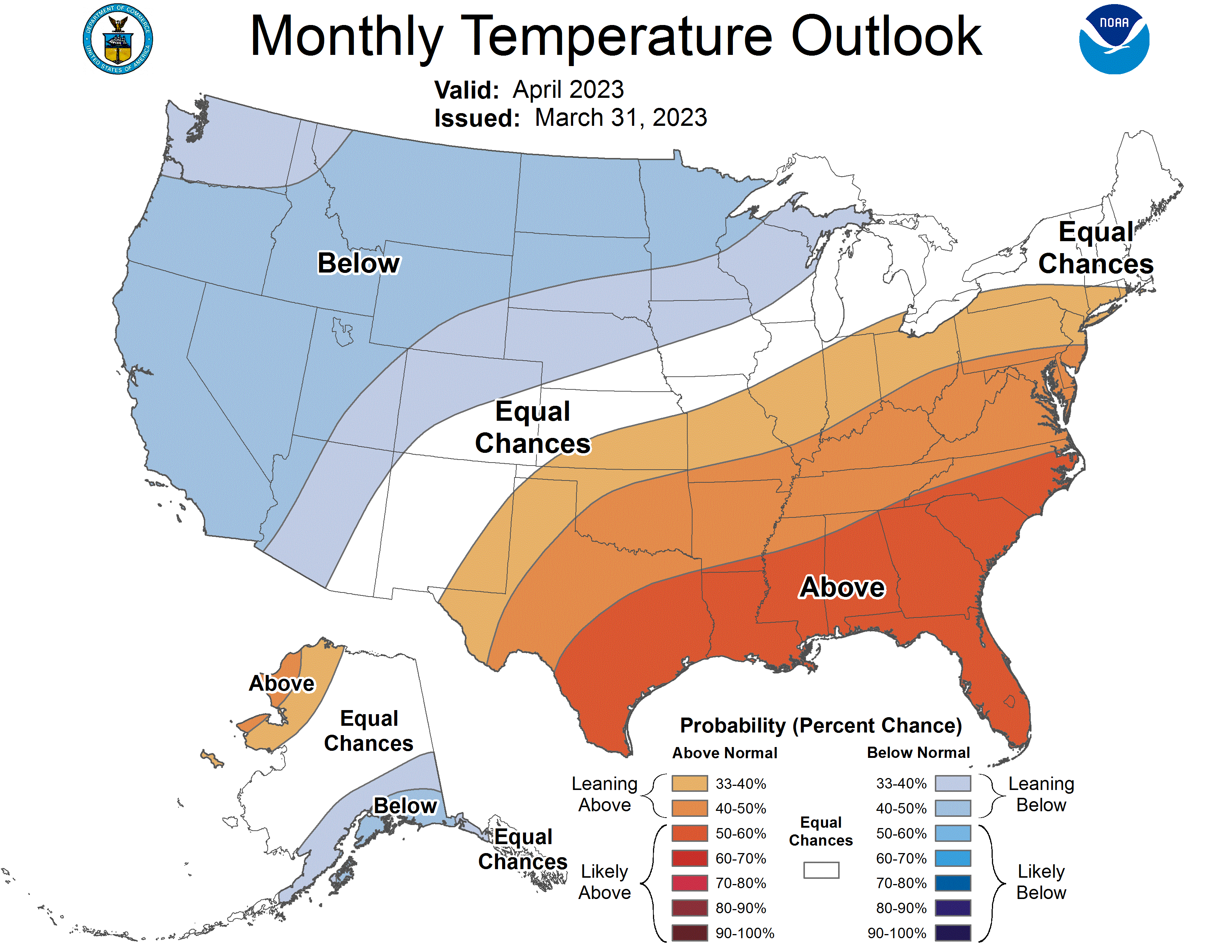
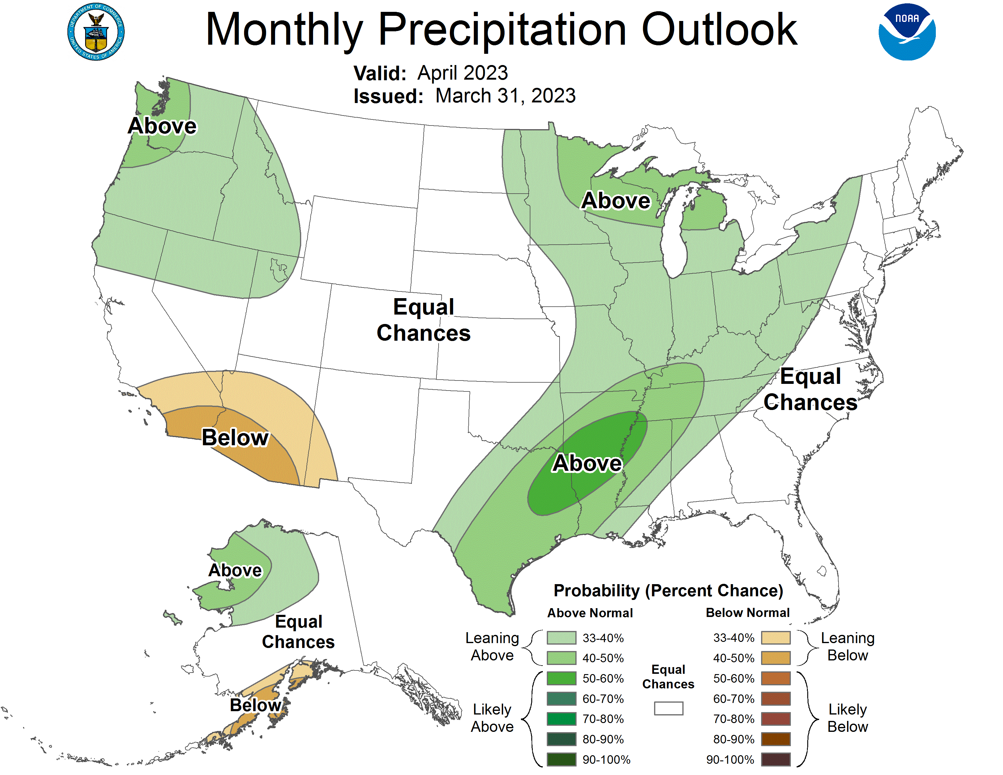
Based on the Climate Prediction Center's outlook for April, Georgia has a 50% to 60% chance for above normal temperatures. Far northwest Georgia has a 33% to 40% chance of above normal precipitation. Central Georgia has an equal chance for above or below normal precipitation.
 |
 |
Data prepared by NWS Peachtree City/Atlanta.

