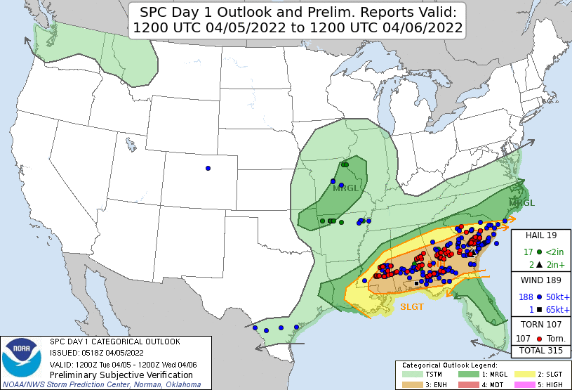
A moist and unstable airmass across the Southeast set the stage for two rounds of severe weather on April 5 and April 6, 2022.
April 5th brought widespread severe thunderstorms to central Georgia with damaging winds and tornadoes commonplace. Fifteen tornadoes occurred during the afternoon and evening hours of April 5th across central Georgia. While most tornadoes were EF-0 to EF-1 intensity, the strongest were an EF-2 tornado in Dooly County and an EF-3 tornado in Houston County. Fortunately, no serious injuries or deaths occurred.
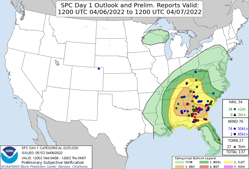
April 6th brought an additional round of severe weather as widespread thunderstorms again developed amid building instability during the afternoon hours. Scattered reports of large hail and damaging wind gusts occurred through the afternoon and evening. Additionally, six more tornadoes of EF-0 and EF-1 intensity occurred in central Georgia. A cold front on the night of April 6th finally put an end to the severe weather threat.
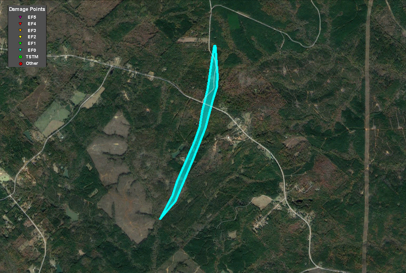
A tornado touched down on the east side of Fort Benning over northeast Chattahoochee County as a line of strong to severe thunderstorms crossed the area. Given the location of the tornado, a majority of the damage was to trees that were seen snapped or uprooted. An aerial survey along with radar data and ground pictures confirmed the track was just under 7 miles with maximum winds around 90 mph (EF-1 rating). The tornado appeared to lift just before the Marion County line.
Damage Path - Chattahoochee County
County
Rating
# of Injuries
KML
Chattahoochee
EF-1
0
Rating:
EF-1
Peak Wind:
90 MPH
Path Length:
6.7 miles
Path Width:
300 yards
Fatalities:
0
Injuries:
0
Start Date:
April 5, 2022
Start Time:
2:04 PM EDT
Start Lat/Lon:
32.3804 / -84.7560
End Date:
April 5, 2022
End Time:
2:09 PM EDT
End Lat/Lon:
32.4330 / -84.6591
All of the damage in this tornado consisted of snapped and uprooted trees in a rural area of Fort Benning.
An EF-1 tornado quickly spun up as it entered Taylor County near the county line in the community of Mauk. Several trees were snapped and uprooted along Mt. Zion Church Road. The tornado continued east, quickly intensifying to max intensity as it crossed Highway 90. Numerous trees were snapped and uprooted on both sides of Highway 90. Also noteworthy were large clumps of grass pulled up from the ground in an open field on the west side of Highway 90. The tornado continued ENE where several homes sustained damage along Henry Currington Road, either from wind damaging the roofs or trees falling onto or near them. The storm continued along Henry Currington Road where a chicken house was nearly destroyed and a nearby home sustained minor roof damage with a nearby barn also completely collapsed. The tornado continued ENE into a largely uninhabited wooded area where both radar and areal survey confirm it weakened and lifted.
Damage Path - Taylor County
County
Rating
# of Injuries
KML
Taylor
EF-1
0
Rating:
EF-1
Peak Wind:
100 MPH
Path Length:
3.1 miles
Path Width:
150 yards
Fatalities:
0
Injuries:
0
Start Date:
April 5, 2022
Start Time:
2:29 PM EDT
Start Lat/Lon:
32.5325 / -84.4431
End Date:
April 5, 2022
End Time:
2:35 PM EDT
End Lat/Lon:
32.5492 / -84.3949
This home experienced roof damage in the tornado.
The tornado downed a number of trees along its path.
The parent storm responsible for the EF-1 tornado in western Taylor County recycled and a new tornado formed near the McCants Mill Pond area along Thomaston Highway north of Butler. A few trees were snapped and uprooted along the highway. The tornado continued northeast in a largely uninhabited forested area before crossing Roberta Highway, snapping and uprooting trees. The tornado reached maximum intensity in the Fickling Mill area where large groves of trees were completely snapped and/or uprooted as it crossed Roberta Highway east of Fickling Mill. Several trees were downed in and around Fickling Mill, and some damage was noted at the mill as well. The EF-1 tornado lifted before reaching the county line in the Pearce Road area. Areal survey confirms the tornado lifted before reaching the county line.
Damage Path - Taylor County
County
Rating
# of Injuries
KML
Taylor
EF-1
0
Rating:
EF-1
Peak Wind:
105 MPH
Path Length:
7.3 miles
Path Width:
300 yards
Fatalities:
0
Injuries:
0
Start Date:
April 5, 2022
Start Time:
2:50 PM EDT
Start Lat/Lon:
32.6140 / -84.2418
End Date:
April 5, 2022
End Time:
2:59 PM EDT
End Lat/Lon:
32.6717 / -84.1379
Portions of this home were damaged.
A large number of trees were snapped, some near their bases.
An EF-1 tornado first touched down south of Ideal in the Fountainville community in Macon County. Numerous trees were snapped and uprooted along County Road 240 near the Buck Creek Bridge. The tornado continued tracking northeast, following Buck Creek in a heavily wooded region before crossing Georgia Highway 90 at a Tyson Plant. Minor damage occurred in and around the plant as well as to a nearby mobile home. Trees were also snapped and uprooted on both sides of Highway 90. The tornado continued northeast, crossing County Road 56 and snapping trees before reaching Whitewater State Park where both ground survey and radar confirm it likely reached maximum intensity. Numerous trees were snapped and uprooted as it crossed Highway 128. Several buildings at the park also sustained damage. The tornado continued northeast, crossing the Flint River and heavily wooded areas before crossing Highway 49, snapping a few trees and beginning to weaken. The storm continued northeast, crossing mostly farm fields and County Road 227 and eventually Perkins Farm Road, where a small outbuilding was destroyed. The tornado lifted shortly thereafter near Highway 224.
Damage Path - Macon County
County
Rating
# of Injuries
KML
Macon
EF-1
0
Rating:
EF-1
Peak Wind:
105 MPH
Path Length:
17.5 miles
Path Width:
250 yards
Fatalities:
0
Injuries:
0
Start Date:
April 5, 2022
Start Time:
3:01 PM EDT
Start Lat/Lon:
32.3070 / -84.1690
End Date:
April 5, 2022
End Time:
3:24 PM EDT
End Lat/Lon:
32.3913 / -83.8893
A large number of trees were snapped and uprooted, especially near Whitewater State Park.
These trees and power lines were downed near Whitewater State Park.
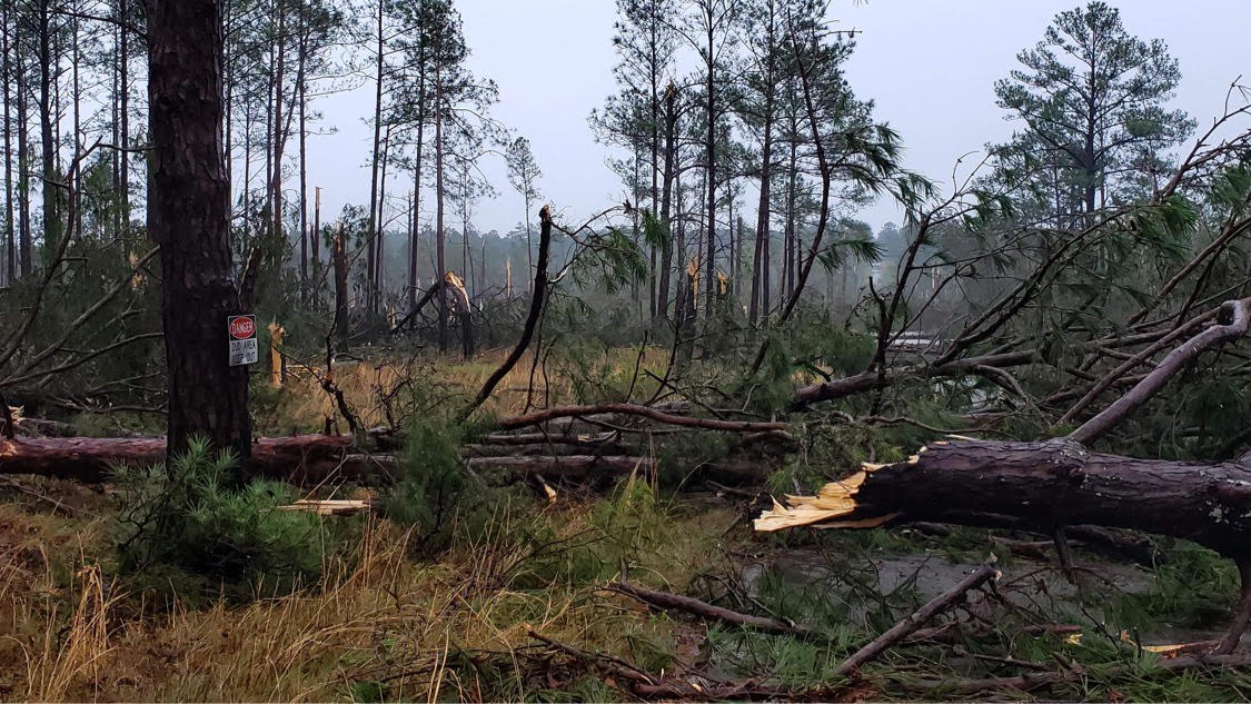
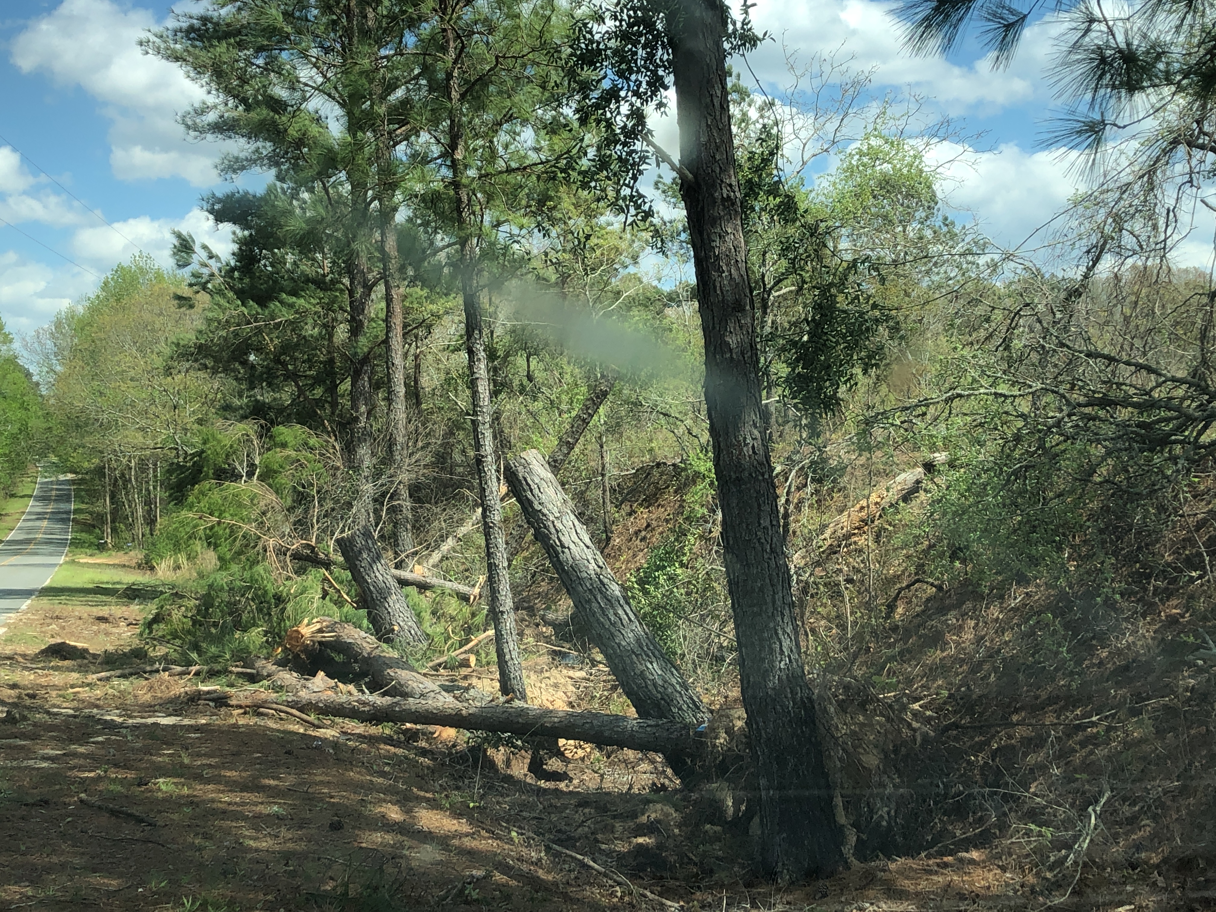
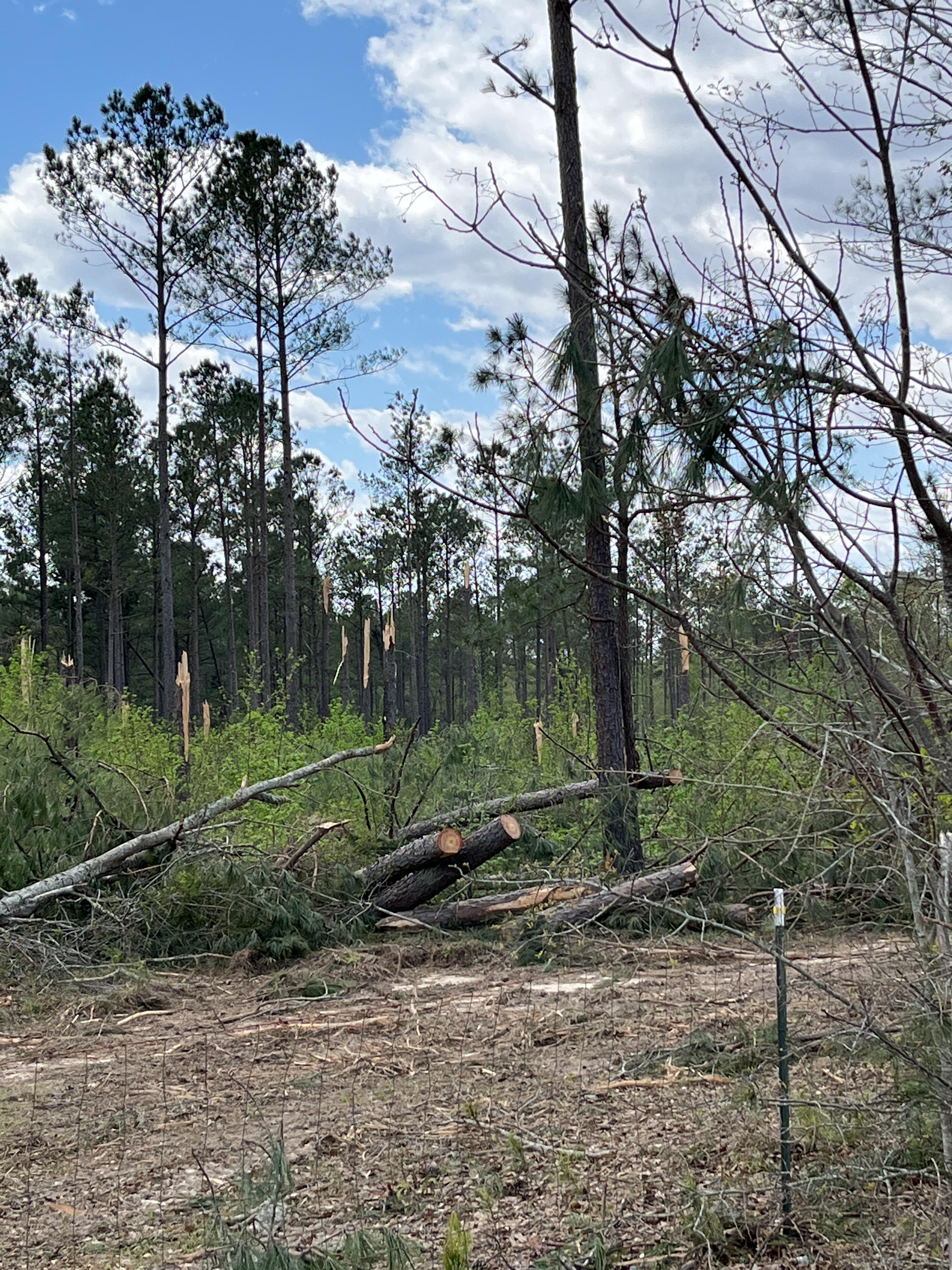
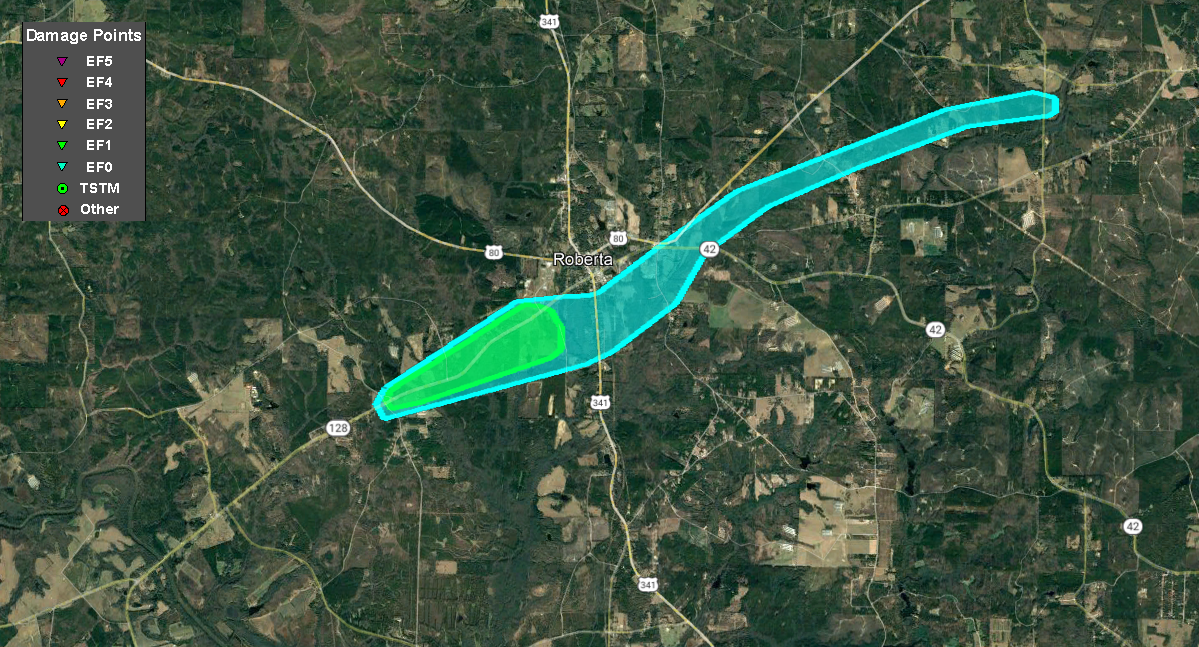
The parent storm responsible for tornadoes in Taylor County recycled yet again in Crawford County, and another EF-1 tornado touched down as it approached the town of Roberta from the southwest. The tornado first touched down along Highway 128 and Pope Road, snapping a few trees before destroying two barns at a farm on the south side of Highway 128 and severely damaging a third. The home nearby also sustained significant roof damage and broken windows. The tornado crossed to the north side of Highway 128, traveling through mostly wooded areas before reaching several homes along Rigdon Road and Beech Boulevard. Numerous trees were snapped and uprooted around the homes. A shed was lifted and flipped over on its roof, a car was smashed by a tree, and some siding and roof damage occurred to the two homes. The storm crossed Highway 128 again where several homes sustained shingle damage, and numerous trees were snapped and uprooted along Seagler Road and Myrtle Drive. The tornado continued east, crossing South Duggar Avenue and South Matthews Street, snapping and uprooting trees with mostly EF-0 type wind damage. The storm then turned northeast, crossing Highway 42 near Old Knoxville Road where a few trees were downed. The storm then continued northeast, crossing Running Deer Road, Sandy Point Circle, and Daisy Lane before lifting shortly after crossing Causey Road. All of the damage from the south side of Roberta east to the end of the path was EF-0. The EF-1 level damage occurred from the beginning of the path to Rigdon Road.
Damage Path - Crawford County
County
Rating
# of Injuries
KML
Crawford
EF-1
0
Rating:
EF-1
Peak Wind:
100 MPH
Path Length:
9.1 miles
Path Width:
200 yards
Fatalities:
0
Injuries:
0
Start Date:
April 5, 2022
Start Time:
3:07 PM EDT
Start Lat/Lon:
32.6957 / -84.0560
End Date:
April 5, 2022
End Time:
3:19 PM EDT
End Lat/Lon:
32.7498 / -83.9184
The tornado damage this mobile home and the trees surrounding it.
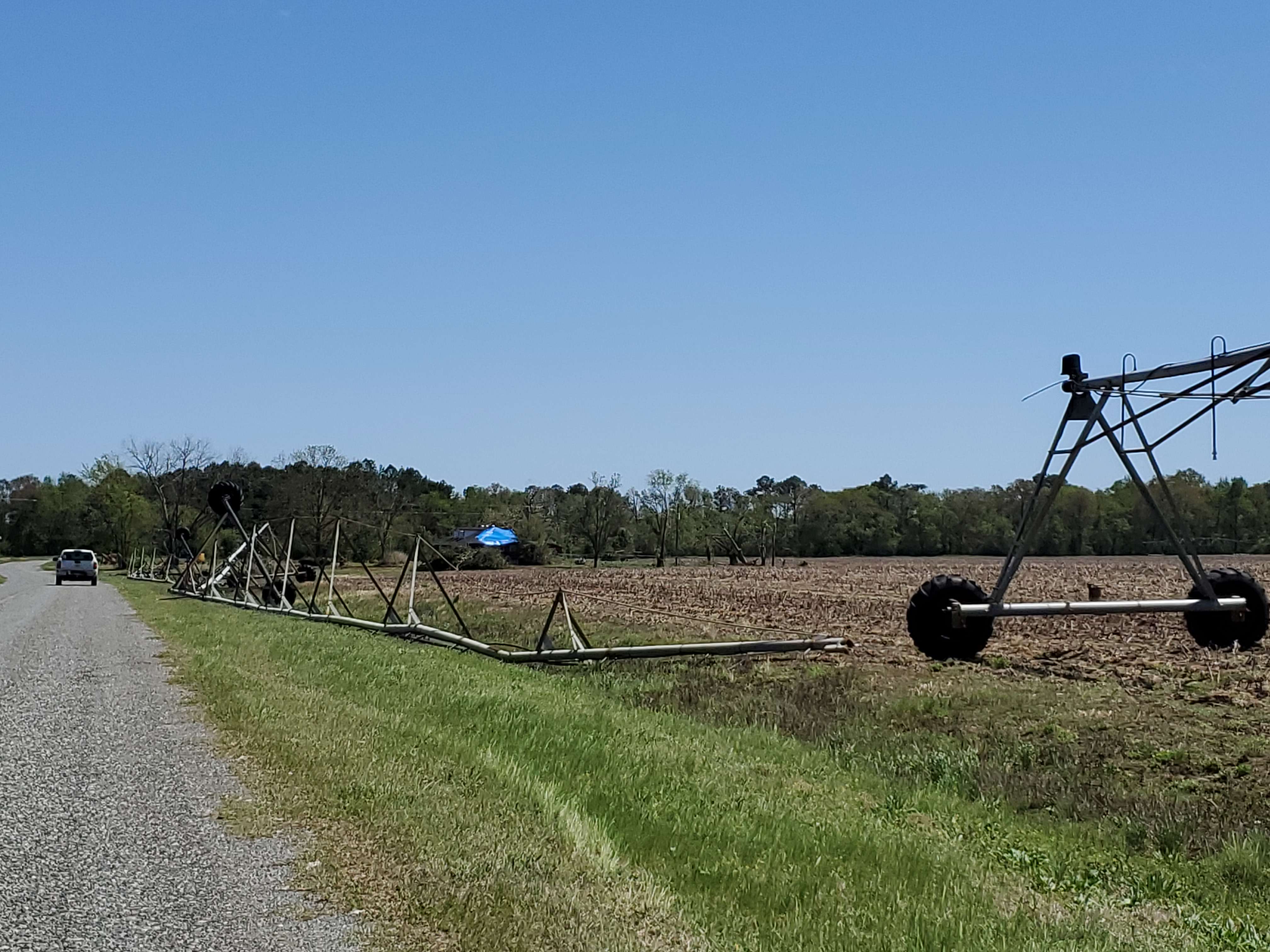
A tornado rapidly developed and intensified near Pinehurst-Byromville Road and Nelleville Road east of Byromville, destroying five large, strongly-anchored grain bins. Most of the 4-foot long, 1-foot wide concrete anchors holding the bins in place were ripped out of the ground, and a 6-inch steel beam that was still attached to another concrete anchor still in the ground was bent to a 20-degree angle. The bins were less than 5 years old and each bolted to concrete foundations yet were ripped out of their foundations and thrown 20 to 30 yards away. Some of the steel paneling of the bins was thrown 1/2 mile east into trees in a nearby field. A semi-tractor trailer at this intersection was ripped from its rig and thrown 30 feet across Nelleville Road. A University of Georgia Mesonet weather station also located at this intersection was damaged but continued to report wind and pressure data (the cup of the anemometer did not appear damaged), measuring a maxium gust of 129.3 mph. Based on this level of damage in the immediate surrounding area, it was determined the weather station's wind gust measurement was accurate, and total peak wind was estimated at 130 mph.
The intensity of damage decreased as the tornado traveled east-northeast, uprooting or snapping numerous trees and rolling over at least 6 irrigation towers along the path. Some barns and outbuildings were also destroyed. Towards the end of the almost 6-mile path, a home on Collins Road east of Old National Highway received minor roof damage. The tornado lifted near Collins Road west of Indian Boundary Road, about 2 miles west of I-75.
Damage Path - Dooly County
County
Rating
# of Injuries
KML
Dooly
EF-2
0
Rating:
EF-2
Peak Wind:
130 MPH
Path Length:
5.9 miles
Path Width:
300 yards
Fatalities:
0
Injuries:
0
Start Date:
April 5, 2022
Start Time:
3:26 PM EDT
Start Lat/Lon:
32.1890 / -83.8806
End Date:
April 5, 2022
End Time:
3:33 PM EDT
End Lat/Lon:
32.2094 / -83.7843
This irrigation equipment was moved and flipped by the tornado.
This UGA Mesonet site recorded a 129 mph wind gust in the tornado.
A brief tornado touched down on the north side of Macon, very near the Piedmont Northside Hospital, taking down a few trees as it moved northeast. More significant damage was quickly seen around the Wimbush Road and Old Lundy Road intersection. A Church steeple was heavily damaged along with multiple larger trees that were snapped or uprooted. Some structural damage (mainly minor roof) damage occurred in this area, especially between Crestline Drive and Thornwood Drive, just west of I-75.
Damage Path - Bibb County
County
Rating
# of Injuries
KML
Bibb
EF-1
0
Rating:
EF-1
Peak Wind:
90 MPH
Path Length:
2.0 miles
Path Width:
100 yards
Fatalities:
0
Injuries:
0
Start Date:
April 5, 2022
Start Time:
3:33 PM EDT
Start Lat/Lon:
32.8716 / -83.6970
End Date:
April 5, 2022
End Time:
3:36 PM EDT
End Lat/Lon:
32.8816 / -83.6642
Some homes along Thornwood Drive received damage from falling trees.
These trees were downed along Thornwood Drive.
This home experienced significant damage from falling trees.
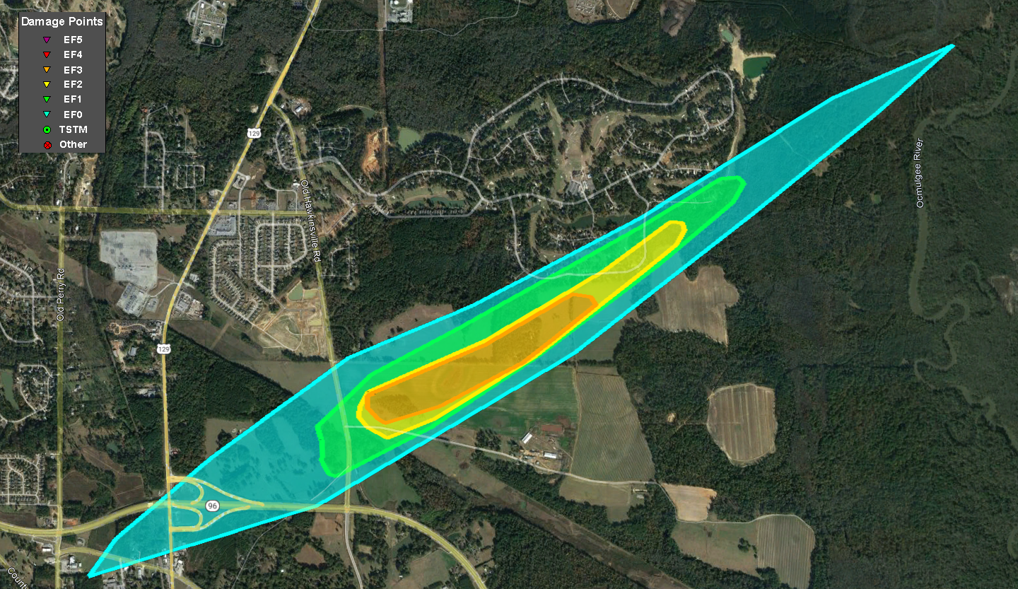
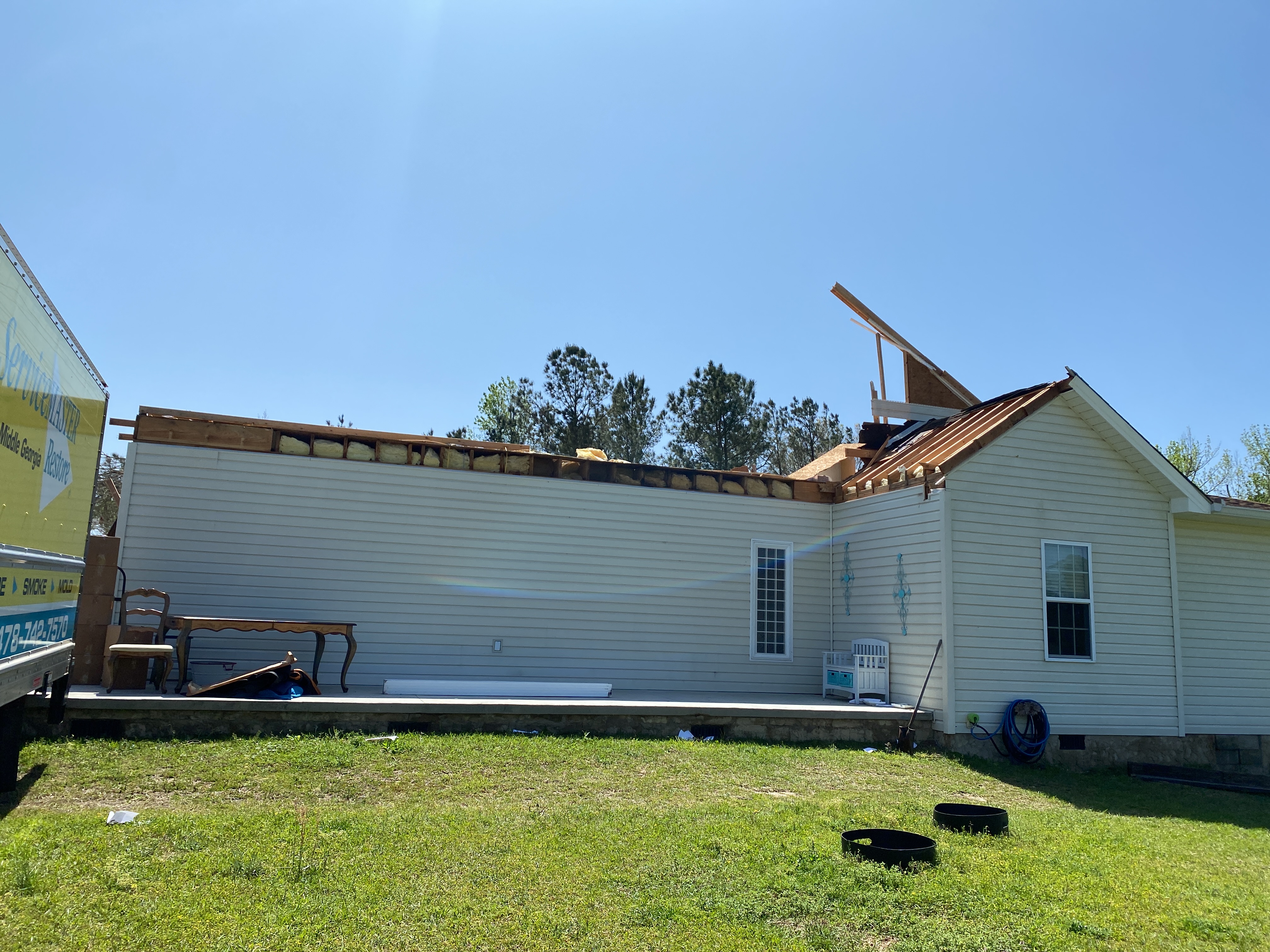
A tornado rapidly intensified as it approached the Bonaire community in northeast Houston County during the mid afternoon hours of Tuesday, April 5th. As the tornado went across an open field near the Old Hawkinsville Road and Cullen Road intersection, two large high-tension power transmission towers were destroyed, and another large concrete power pole was snapped near its base. Winds between 135 and 155 mph are a typical maximum wind-load range for these electric towers/poles, supporting the rapidly developing, now-strong (EF2+) tornado.
The tornado crossed the open field and did significant damage to multiple homes. The first house had large sections of its roof and second floor window removed/torn away, along with numerous large trees surrounding the property snapped near their bases. Not more than 150 yards to the northeast, two additional homes were hit hard, with one completely destroyed. The damage around these areas was consistent with EF-2 to EF-3 rating, with max winds approaching 160 mph.
Less than two minutes later, the powerful tornado hit the south side of the Stathams Landing neighborhood where multiple homes had minor to significant damage, particularly along Fairways Drive, where parts of the roof and second story were destroyed, in addition to numerous large trees being snapped and uprooted around the properties. Thankfully, the tornado appeared to have weakened slightly here, but EF-1 to low end EF-2 damage was still noted. Beyond Fifth Fairway (street) is open field/marsh area before Sandy Run Creek and the county line. Little additional damage occurred here, and this drastic weakening of the tornado was supported by radar as well.
Damage Path - Houston County
County
Rating
# of Injuries
KML
Houston
EF-3
1
Rating:
EF-3
Peak Wind:
160 MPH
Path Length:
3.9 miles
Path Width:
820 yards
Fatalities:
0
Injuries:
1
Start Date:
April 5, 2022
Start Time:
3:49 PM EDT
Start Lat/Lon:
32.5480 / -83.6024
End Date:
April 5, 2022
End Time:
3:56 PM EDT
End Lat/Lon:
32.5780 / 83.5458
These two steel high-tension electrical towers were crumpled by the tornado and are typically rated to between 135 and 155 mph.
This home off of Old Hawkinsville road was nearly completely destroyed.
This home off of Old Hawkinsville Road also received major damage.
The EF-3 tornado completely destroyed this home off of Old Hawkinsville Road.
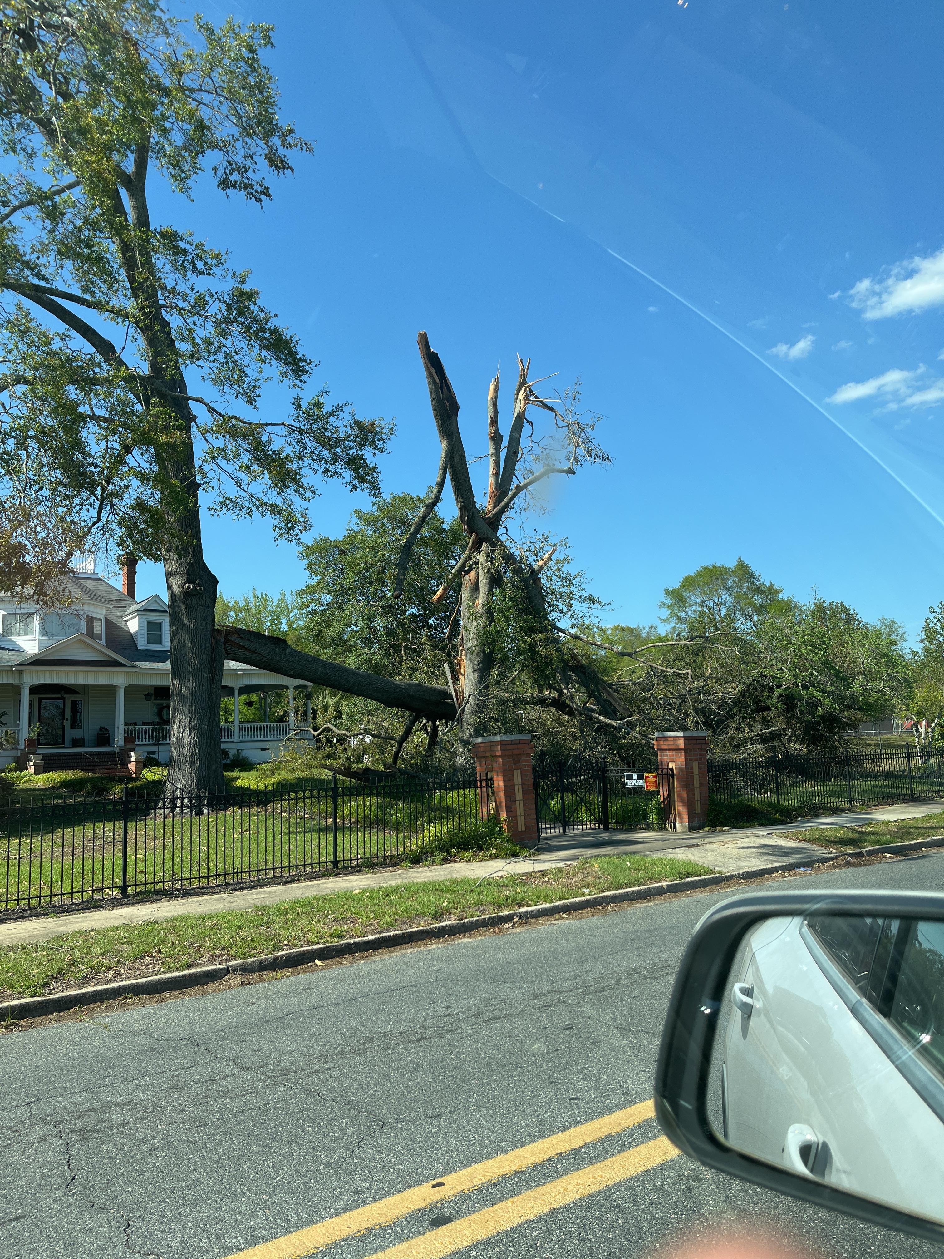
A brief tornado touched down west-northwest of Milledgeville just after 4 PM on April 5th. More than 100 trees were reported down around a property just south of the Old Monticello Road NW and Avery Store Road intersection, with additional trees snapped or uprooted about 1/2 mile up along Avery Store Road. A weak TDS was evident from radar as the circulation moved NNE.
Damage Path - Baldwin County
County
Rating
# of Injuries
KML
Baldwin
EF-0
0
Rating:
EF-0
Peak Wind:
75 MPH
Path Length:
1.7 miles
Path Width:
150 yards
Fatalities:
0
Injuries:
0
Start Date:
April 5, 2022
Start Time:
4:01 PM EDT
Start Lat/Lon:
33.0950 / -83.3493
End Date:
April 5, 2022
End Time:
4:03 PM EDT
End Lat/Lon:
33.1185 / -83.3409
Many trees were snapped and uprooted along Avery Store Road.
A high-end EF-1 tornado quickly tracked across far eastern Twiggs into southwest Wilkinson County. At its strongest, along Highway 96 south of Jeffersonville, the tornado was roughly 1.5 miles south of the KJGX WSR-88D Radar. In this Highway 96 area, five homes were damaged, including where a corner section/garage area of one home collapsed, though the roof and exterior walls remained intact. Numerous trees around this property were either snapped (some near the base) or uprooted. Across the street on the west side of Highway 96, a manufactured home was pushed off its foundation with significant roof and siding damage. Another home had part of its roof and chimney collapse with significant loss of its roof covering. The structural (and tree) damage is consistent with maximum winds between 100-110 MPH, which puts this tornado at a high-end EF-1.
As the tornado continued to cycle and track east toward the Wilkinson County line, it encountered mainly rural areas and open fields before crossing Highway 80, about 2.3 miles southeast of Jeffersonville. Several trees were seen snapped or uprooted with minor roof/shingle damage to a small one-story home. On the Wilkinson County side, damage picked back up between Sinclair Drive and Old Macon Road. This was mainly tree damage with minor structural damage to a home along with several property fences blown down. Farther northeast, multiple trees were snapped or uprooted along McCue Road and Knightpond Road, just before turning into Stuckey Road. Based on radar, additional damage (trees) was likely along Pleasant Plains Church Road, but that road was flooded at the time of this ground survey. The end point was placed just beyond this road.
Damage Path - Twiggs & Wilkinson Counties
County
Rating
# of Injuries
KML
Twiggs/Wilkinson
EF-1
0
Rating:
EF-1
Peak Wind:
110 MPH
Path Length:
12.4 miles
Path Width:
400 yards
Fatalities:
0
Injuries:
0
Start Date:
April 5, 2022
Start Time:
4:11 PM EDT
Start Lat/Lon:
32.6484 / -83.3773
End Date:
April 5, 2022
End Time:
4:22 PM EDT
End Lat/Lon:
32.7144 / -83.1802
The tornado damaged this home along Highway 96 in Twiggs County.
The tornado snapped and uprooted numerous trees along Highway 96 about 1.5 miles south of the JGX radar in Twiggs County.
The tornado snapped and uprooted a large number of trees in Wilkinson County.
These trees were downed along Old Macon Road in Wilkinson County.
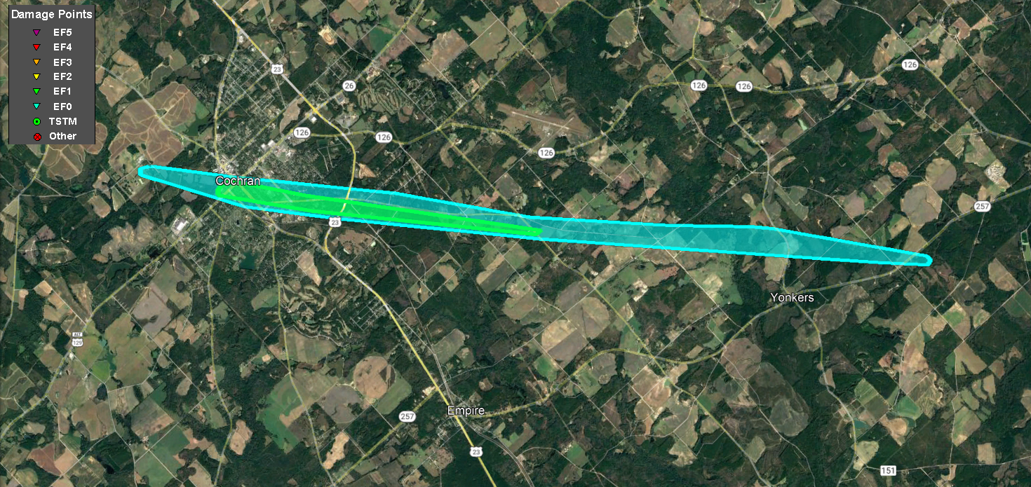
A QLCS EF-1 tornado quickly developed on the southeast side of the community of Cochran. The tornado spun up on the west side of Highway 23 where the second story of a home was removed and nearby trees were snapped and uprooted. The tornado crossed Highway 23, hitting another home and causing damage to the carport and roof. The storm continued ENE, crossing Roddy Highway and Frank Brown Road and snapping and uprooting a few trees. The tornado crossed Macedonia Church Road where EF-1 level tree damage was noted on the east side of the road. The tornado quickly weakened and lifted as it reached Nicholson Carr Road.
Damage Path - Bleckley & Dodge Counties
County
Rating
# of Injuries
KML
Bleckley/Dodge
EF-1
0
Rating:
EF-1
Peak Wind:
95 MPH
Path Length:
7.7 miles
Path Width:
125 yards
Fatalities:
0
Injuries:
0
Start Date:
April 5, 2022
Start Time:
4:14 PM EDT
Start Lat/Lon:
32.3497 / -83.3145
End Date:
April 5, 2022
End Time:
4:23 PM EDT
End Lat/Lon:
32.2818 / -83.1899
The roof was blown off of this building.
These trees were snapped on Macedonia Church Road.
A tornado touched down several miles south-southwest of Abbeville in Wilcox County, destroying a mobile home and overturning another trailer off of Briarwood Road, just south of American Legion Road. The tornado snapped or uprooted multiple trees as it tracked northeast across Fullmers Lake and Highway 129 South. Heading across the Ocmulgee River into southwest Dodge County, additional damage was picked back up at a hunting camp just off Adams Springs Road. At this location, multiple campers were damaged or overturned, and numerous trees were uprooted, some laying on buildings. Additional trees were littered across Will Reeves Road heading toward Rhine, but the tornado lifted before reaching the center of town.
A brief QLCS EF-0 tornado quickly evolved within the line of storms which moved through central Georgia on the afternoon of Tuesday, April 5, 2022. The tornado touched down southeast of Adrian along Hidden Acres Lane where several trees were snapped and uprooted. The tornado continued northeast, crossing Crooked Run Road before lifting.
Damage Path - Treutlen County
County
Rating
# of Injuries
KML
Treutlen
EF-0
0
Rating:
EF-0
Peak Wind:
80 MPH
Path Length:
2.8 miles
Path Width:
100 yards
Fatalities:
0
Injuries:
0
Start Date:
April 5, 2022
Start Time:
5:10 PM EDT
Start Lat/Lon:
32.4624 / -82.5512
End Date:
April 5, 2022
End Time:
5:12 PM EDT
End Lat/Lon:
32.4670 / -82.5372
This weak tornado caused varying degrees of tree damage.
14) Treutlen County Tornado (Ohoopee Bend Crescent):
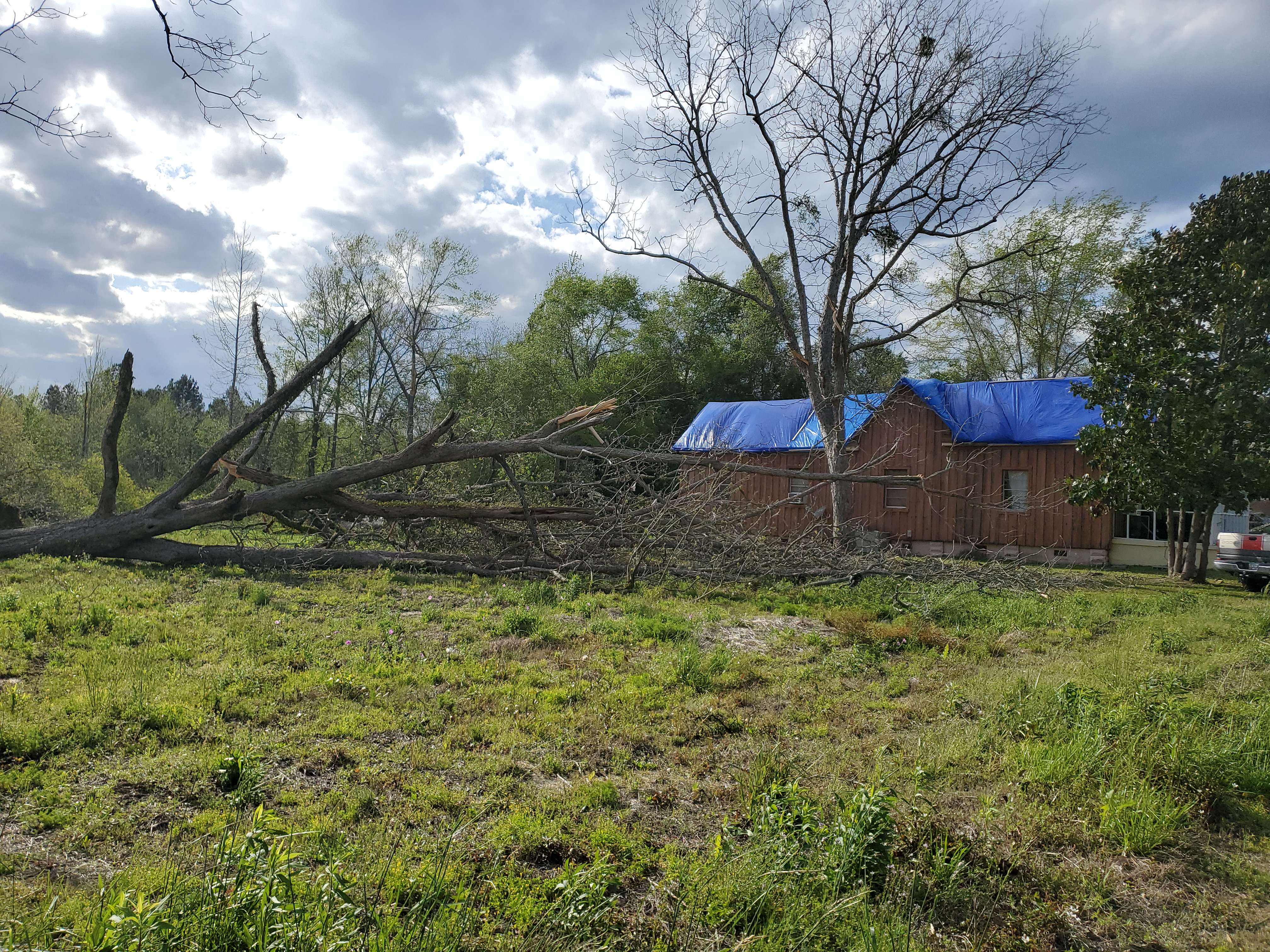
A fast-moving tornado began south of the intersection of Holton Chapel Road and Ohoopee Bend Crescent and traveled north-northeast, destroying several barns and outbuildings and heavily damaging two homes on Ohoopee Bend Crescent. Tin roofing from the barns and homes were thrown up to a third of a mile away. A carport failed, allowing half of a roof to be blown off of one home. Another home built in the 1930s also had its carport blown off and one-third of the roof blown off. A double-wide trailer home was moved off its foundation and had significant loss of siding and shingles but remained intact. Almost all of the 100 trees in the area of the trailer were snapped or uprooted. This area received the highest maximum wind speed estimate of 110 mph. The tornado continued north-northeast near the end of County Road 161, downing trees and damaging outbuildings before weakening and dissipating over uninhabited areas near the Ohoopee and Little Ohoopee Rivers.
Damage Path - Treutlen County
County
Rating
# of Injuries
KML
Treutlen
EF-1
0
Rating:
EF-1
Peak Wind:
110 MPH
Path Length:
0.8 miles
Path Width:
200 yards
Fatalities:
0
Injuries:
0
Start Date:
April 5, 2022
Start Time:
5:17 PM EDT
Start Lat/Lon:
32.4467 / -82.4260
End Date:
April 5, 2022
End Time:
5:18 PM EDT
End Lat/Lon:
32.4554 / -82.4176
The tornado caused significant damage to this mobile home and surrounding trees.
The same mesovortex that produced a brief tornado in north-central Treutlen County on April 5th spun up another weak tornado southwest of Swainsboro near Kemp Road and Ebenezer Church Road. It traveled northeast, downing several trees, then traveled near the intersection of US-80 and US-1 as it entered the city limits. More trees were snapped or uprooted along the path as it traveled into the city. Several businesses near downtown had a large amount of tin roofing blown off and into the streets. A few signs were also blown down. The tornado lifted shortly after this point, just northeast of downtown.
17) Bleckley & Laurens County (Hillbridge Road) Tornado:
The parent storm responsible for the QLCS tornado that impacted the south side of Cochran quickly regenerated a new EF-1 tornado near the Bleckley and Laurens County line south of West Chicken Road. Trees were snapped and uprooted as the tornado crossed Branch Road. The tornado quickly reached maximum intensity along Hillbridge Road where hundreds of trees were snapped and uprooted. The storm continued east into a wooded area before lifting at Thompson Road.
Damage Path - Bleckley & Laurens Counties
County
Rating
# of Injuries
KML
Bleckley/Laurens
EF-1
0
Rating:
EF-1
Peak Wind:
105 MPH
Path Length:
1.8 miles
Path Width:
250 yards
Fatalities:
0
Injuries:
0
Start Date:
April 5, 2022
Start Time:
6:30 PM EDT
Start Lat/Lon:
32.4398 / -83.1547
End Date:
April 5, 2022
End Time:
6:33 PM EDT
End Lat/Lon:
32.4523 / -83.1281
A significant number of tree were snapped and uprooted along the path.
A significant number of tree were snapped and uprooted along the path.
The tornado touched down southwest of the intersection of New York Road and Larsen Road in Lee County (NWS Tallahassee area) shortly before 3:30 PM. There was roof damage to several homes along the path. The tornado also caused considerable tree damage as it moved northeastward towards Lake Blackshear and weakened somewhat in far southeast Sumter County before lifting. The damage was consistent with an EF-1 tornado with winds of approximately 105 mph. The start point was based on a combination of radar data and video of the tornado initiation found on social media. This tornado affected both the NWS Tallahassee and NWS Peachtree City/Atlanta areas.
A QLCS EF-0 tornado quickly developed along a line of storms the evening of Wednesday, April 6, 2022. The tornado developed near the Twiggs/Bleckley County line along I-16 where several trees were snapped or uprooted. The tornado path closely followed I-16 where several trees were snapped and uprooted, often on one side of the interstate or the other. Radar data confirms the path and storm direction was to the east-southeast, aligning with damage found on the ground along the interstate. The tornado continued for over 3 miles along the interstate, snapping or uprooting trees across Georgia Highway 112 and Eason Hill Church Road in Laurens County before weakening and lifting as it approached Georgia Highway 278 southwest of the town of Montrose. Most of the damage was confined to the area between Mile Markers 32 to 35.
Damage Path - Bleckley & Laurens Counties
County
Rating
# of Injuries
KML
Bleckley/Laurens
EF-0
0
Rating:
EF-0
Peak Wind:
80 MPH
Path Length:
3.7 miles
Path Width:
100 yards
Fatalities:
0
Injuries:
0
Start Date:
April 6, 2022
Start Time:
7:45 PM EDT
Start Lat/Lon:
32.5750 / -83.2443
End Date:
April 6, 2022
End Time:
7:49 PM EDT
End Lat/Lon:
32.5550 / -83.1871
This small pine tree was downed along I-16.
A number of trees were downed alongside either side of I-16 as the tornado followed the interstate.
A QLCS EF-1 tornado formed along Rebie Road in southern Laurens County, moving ESE through a heavily wooded region and snapping and uprooting trees before reaching Lord Road. Two large grain bins were dented, numerous trees were snapped or uprooted, a home sustained roof damage, and a small shed was destroyed. The tornado was at its maximum intensity in this area before moving into a heavily wooded area. The tornado crossed Chicken Road and HIghway 338, snapping a few trees before lifting east of Highway 338 in a wooded area.
Damage Path - Laurens County
County
Rating
# of Injuries
KML
Laurens
EF-1
0
Rating:
EF-1
Peak Wind:
90 MPH
Path Length:
4.9 miles
Path Width:
150 yards
Fatalities:
0
Injuries:
0
Start Date:
April 6, 2022
Start Time:
7:52 PM EDT
Start Lat/Lon:
32.4901 / -83.1557
End Date:
April 6, 2022
End Time:
7:58 PM EDT
End Lat/Lon:
32.4819 / -83.0722
This home received minor roof damage.
A number of pecan trees were downed at this location.
The parent storm which caused the QLCS tornado in Cochran recycled and generated a new EF-1 tornado which touched down south of Chester, downing a few trees along Chester Highway and Coleman Holt Road. Some outbuilding roof damage was noted on Coleman Holt Road, and a tree had fallen on a house. The tornado continue east-southeast along Highway 126, crossing Howard Road and Mount Carmel Church Road, where a few trees were snapped and uprooted. The storm continued east-southeast, crossing Highway 338 and reaching peak intensity along Highway 117 just to the NE of the Cadwell community where numerous trees were uprooted and some damage occurred to a home due to falling trees. A porch cover was destroyed on a home along Moorman Lane. Damage became more intermittent as the tornado continued east, crossing Coleman Farm Road, Highway 441, South Poplar Church Springs Road. Trees were also snapped and uprooted along Scotland Road and St. Mark Road before the tornado lifted in a wooded area east of St. Mark Road.
Damage Path - Dodge & Laurens Counties
County
Rating
# of Injuries
KML
Dodge/Laurens
EF-1
0
Rating:
EF-1
Peak Wind:
95 MPH
Path Length:
16.7 miles
Path Width:
200 yards
Fatalities:
0
Injuries:
0
Start Date:
April 6, 2022
Start Time:
7:53 PM EDT
Start Lat/Lon:
32.3725 / -83.1406
End Date:
April 6, 2022
End Time:
8:11 PM EDT
End Lat/Lon:
32.3380 / -82.8632
The tornado damaged the roof to this mobile home.
A large number of pecan trees were downed in the storm.
The same QLCS that produced the tornado east of Adrian also spawned another tornado at about the same time about 3.75 miles west of Kite. This tornado intensified quickly after it formed about 500 yards southwest of the intersection of Meeks Road and Midas Brantley Road, reaching 105 mph peak intensity as it moved east-northeast. A ranch-style brick home had its carport and one-third of its roof ripped off at this location. Several large trees and power poles were snapped near this intersection. A stop sign was also bent over. As the tornado traveled east-northeast, it took a slight left turn into the southwest and south portion of the city of Kite, causing significant damage to about 20-30 homes, mostly to the roofs. Numerous outbuildings were destroyed, and hundreds of trees were snapped or uprooted. A baseball field sustained heavy damage to the concession building, fencing, and stands. At the cemetery in the eastern part of the city three 500 pound, 8 by 4 foot granite monuments originally laying face down were lifted up by the pressure forces induced by the winds and flipped over. The tornado continued east-northeast and destroyed two large open barns and other outbuildings on Jr Claxton Road near the Johnson-Emanuel county line. After this point the tornado weakened and downed several trees as it crossed Price William Road and eventually lifted just east of Pinetucky Road.
Damage Path - Johnson & Emanuel Counties
County
Rating
# of Injuries
KML
Johnson/Emanuel
EF-1
0
Rating:
EF-1
Peak Wind:
105 MPH
Path Length:
8.5 miles
Path Width:
500 yards
Fatalities:
0
Injuries:
0
Start Date:
April 6, 2022
Start Time:
8:22 PM EDT
Start Lat/Lon:
32.6714 / -82.5734
End Date:
April 6, 2022
End Time:
8:33 PM EDT
End Lat/Lon:
32.7085 / -82.4359
This home in Kite received roof damage, and a number of trees were downed around the property as well.
A fast-moving QLCS produced a 16 mile long-tracked tornado starting just north of Adrian near Meeks Road south of Ohoopee Road downing trees and continuing east-northeast, nearly paralleling a line of US-80. Along Odomville Church Road west of US-221 numerous trees were snapped, some falling on homes. The tornado weakened some then intensified as it crossed Cow Ford Bridge Road, snapping or uprooting 50-100 trees over a wide swath. The tornado weakened as it traveled into rural areas north of and near US-80. The tornado broadened and strengthened a bit as it entered Swainsboro (only 27 hours after another tornado went through this same area) east and southeast of the Swainsboro Golf and Country Club near McLeod Bridge Road, Oaklawn Drive and Kite Road, downing numerous trees and power lines. Farther east, a home on Lucky Street had roof damage from a tree falling on it. The tornado traveled into the Lake Luck area, downing a power pole and a few trees near Fortune Loop Drive and Prosperity Drive. Damage immediately east of this area was much weaker and limited to a few tree limbs after which the tornado lifted around 8:39 PM EDT.
Damage Path - Emanuel County
County
Rating
# of Injuries
KML
Emanuel
EF-1
0
Rating:
EF-1
Peak Wind:
95 MPH
Path Length:
15.9 miles
Path Width:
500 yards
Fatalities:
0
Injuries:
0
Start Date:
April 6, 2022
Start Time:
8:22 PM EDT
Start Lat/Lon:
32.5532 / -82.5730
End Date:
April 6, 2022
End Time:
8:39 PM EDT
End Lat/Lon:
32.6020 / -82.3078
Trees were snapped and uprooted as the tornado approached and entered Swainsboro.
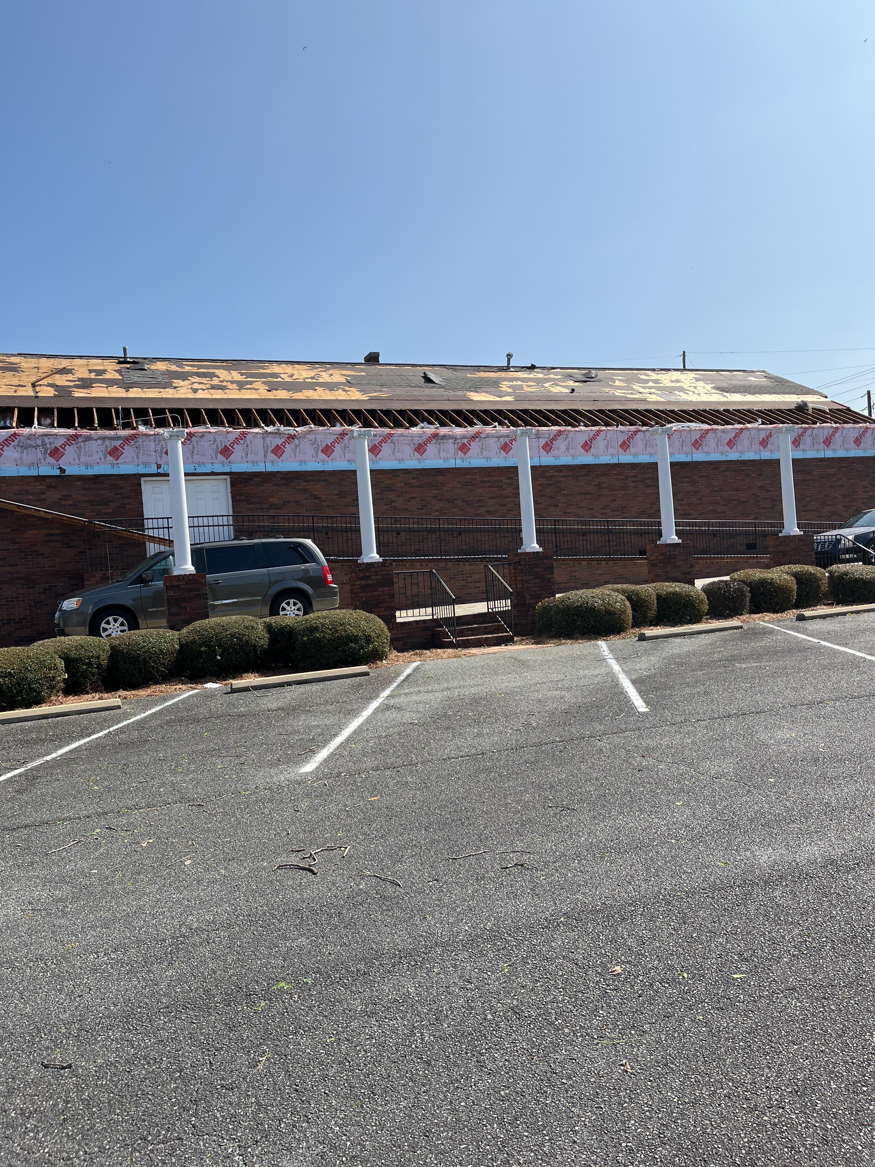
A QLCS tornado quickly developed along a line of storms moving through the town of Cochran during the evening hours of Wednesday, April 6, 2022. The tornado spun up just west of town in a field south of Railroad Avenue. The tornado first crossed West Dykes Street where roof damage was noted to several buildings and nearby homes. The tornado continued southeast through town crossing 2nd and 3rd Streets, snapping and uprooting trees, which caused some damage to homes before reaching Middle Georgia State College. The tornado snapped and uprooted trees on campus in addition to tearing a portion of the roof on one of the campus buildings. The building damage and nearby tree damage at the intersection of 6th Street and College Street was the equivalent of mid-range EF-1 damage. The tornado continued southeast crossing Pine Hill Drive and Willow Drive where numerous trees were snapped and uprooted on or very near homes in that area, causing damage to several. The tornado continued east and began to weaken but still sporadically snapped and uprooted trees along Denny Cooley Road, Frank Cook Road, Roddy Road, Cook Road, and West Chicken Road before lifting near Nicholson Carr Road and County Road 257. It should be noted that the tornado did not appear to be consistently on the ground once it got east of the bypass east of Cochran, and much of the damage east of Cochran was noted as spotty EF-0. However, there was enough damage surveyed close enough together to maintain a consistent track to Country Road 257.
Damage Path - Dodge & Bleckley Counties
County
Rating
# of Injuries
KML
Dodge/Bleckley
EF-1
0
Rating:
EF-1
Peak Wind:
105 MPH
Path Length:
11.4 miles
Path Width:
150 yards
Fatalities:
0
Injuries:
0
Start Date:
April 6, 2022
Start Time:
8:39 PM EDT
Start Lat/Lon:
32.3883 / -83.3783
End Date:
April 6, 2022
End Time:
8:55 PM EDT
End Lat/Lon:
32.3748 / -83.1839
A large number of trees were downed in Cochran.
This building in Cochran received significant roof damage.
An Enhanced Risk (Level 3) was in place for much of the area south of Interstate 20. Storms strengthened amid increasing instability through the afternoon with tornadoes and wind damage common across Middle Georgia.
April 6, 2022:
An Enhanced Risk was again issued for most of the area on April 6th. Hail and damaging wind reports were scattered across the area with the concentration of additional tornadoes again across Middle Georgia.
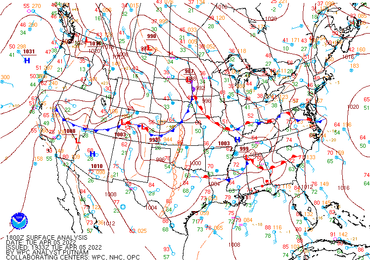
April 5, 2022:
Surface Map, 2 PM EDT
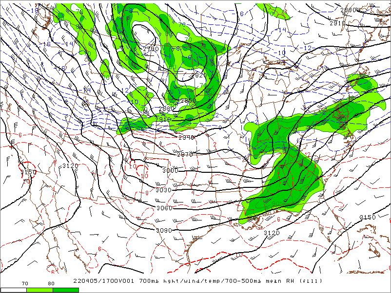
700 mb, 1 PM EDT
A warm and unstable airmass was situated across areas south of a warm front draped near I-20 during the afternoon. Severe thunderstorms developed and intensified in this environment.
A strong upper shortwave disturbance was traversing the area and providing the impetus for thunderstorm development.
0-1km Storm Relative Helicity (SRH), 3 PM EDT
Enhanced 0-1km SRH values were favorable for rotating supercell thunderstorms.
April 6, 2022:
Surface Map, 5 PM EDT
Surface CAPE, 3 PM EDT
A cold front was incoming toward the state with a moist and unstable airmass supporting additional thunderstorm development.
Building instability, with surface CAPE on the order of 2000-3000 J/kg, provided fuel for widespread afternoon and evening thunderstorm development.