An Active End to 2021 and Start to 2022
Several rounds of active weather marked the end of 2021 and beginning of 2022. Severe thunderstorms, including a few tornadoes, occurred on both December 30th and December 31st and again for parts of the north Georgia on January 1st. December 2021 was an unusually warm and unseasonable month with little in the way of cold temperatures. In fact, it was the 2nd warmest December on record in Athens, Macon, and Columbus and the 3rd warmest on record in Atlanta. The environment was therefore more supportive of Spring-like thunderstorms than winter weather. Cold air did finally arrive by January 2nd and 3rd, but with it came a bit of snow for the north Georgia mountains as well as strong wind gusts up to 50 mph across north Georgia which resulted in scattered downed trees and power outages.
1) Cherokee County Tornado:
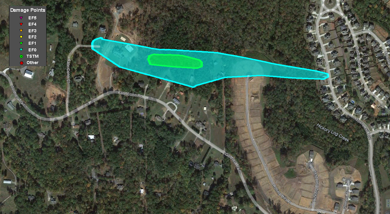
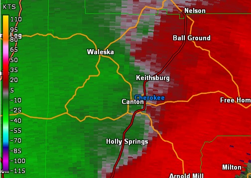
A low-end EF-1 tornado briefly touched down in northern Cherokee County on Thursday, December 30, 2021 during the very early hours of the morning as a line of thunderstorms moved through the region. The tornado first touched down north of Fate Conn Road, located northwest of Canton, near some homes along the road. Several trees were uprooted, and a large trampoline was thrown to the west approximately 150 yards into a neighboring home. Near the beginning of the track, a large bedroom window was also blown in on a large home, and a large fence on a tennis court was blown down. As the storm continued east, it intensified to max intensity in a wooded area where hundreds of trees were snapped or uprooted behind several homes along Fate Conn Road. A small barn and an RV were destroyed by numerous falling trees in the core of the path. A home along Rolling Hills Place had a tree fall into it. The storm continued east, snapping trees before lifting just before Towne Mill Avenue.
|
|
|
|
|
| Numerous trees were downed in this wooded area where the tornado reached peak intensity. | This RV was crushed by falling trees. |
|
|
 |
| Reflectivity (11:20 PM EST). | Velocity (11:20 PM EST). |
2) Hall County Tornado:
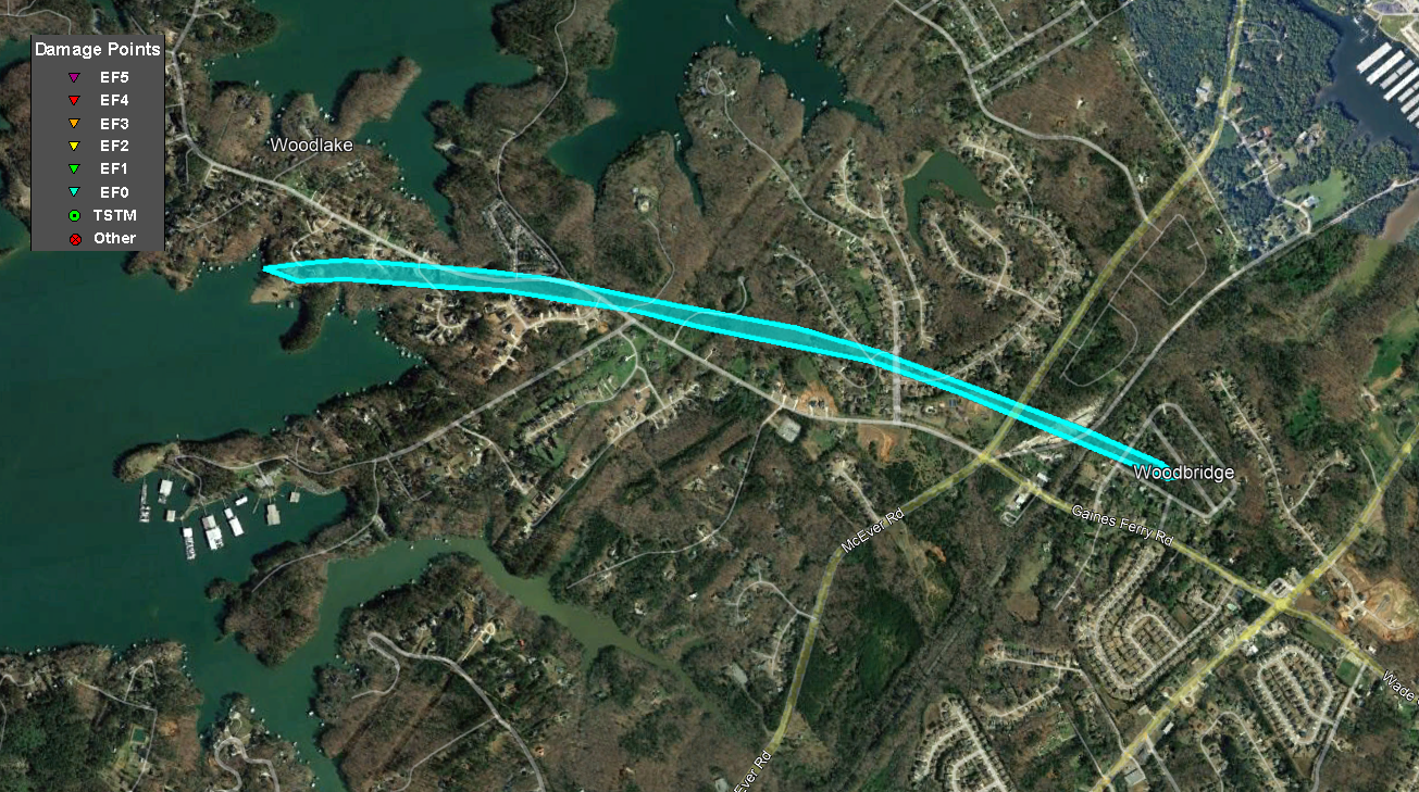
A brief, weak tornado spun up nearly immediately behind a line of strong showers and thunderstorms as is tracked across southern Hall County. Based on radar and NWS ground surveys, the narrow tornado appeared to touch down between Sweetwater Point and Club View Court, just south of Gaines Ferry Road. In this area, several trees were snapped or uprooted with one falling onto a 2-car garage. Additional trees were seen snapped or uprooted in a fairly consistent path from Secret Cove Court to Athletic Club Drive. The damage appeared to get more sporadic, but additional tree damage was seen along the storm's path until around Laurelwood Trail and Sweetgum Trail, which is just north of Gaines Ferry Road. This tornado took an east-southeast track behind the main leading line of storms.
|
|
|
|
|
| A number of trees were downed in this tornado. | These trees were snapped or uprooted. |
|
|
 |
| Reflectivity (12:03 AM EST). | Velocity (12:03 AM EST). |
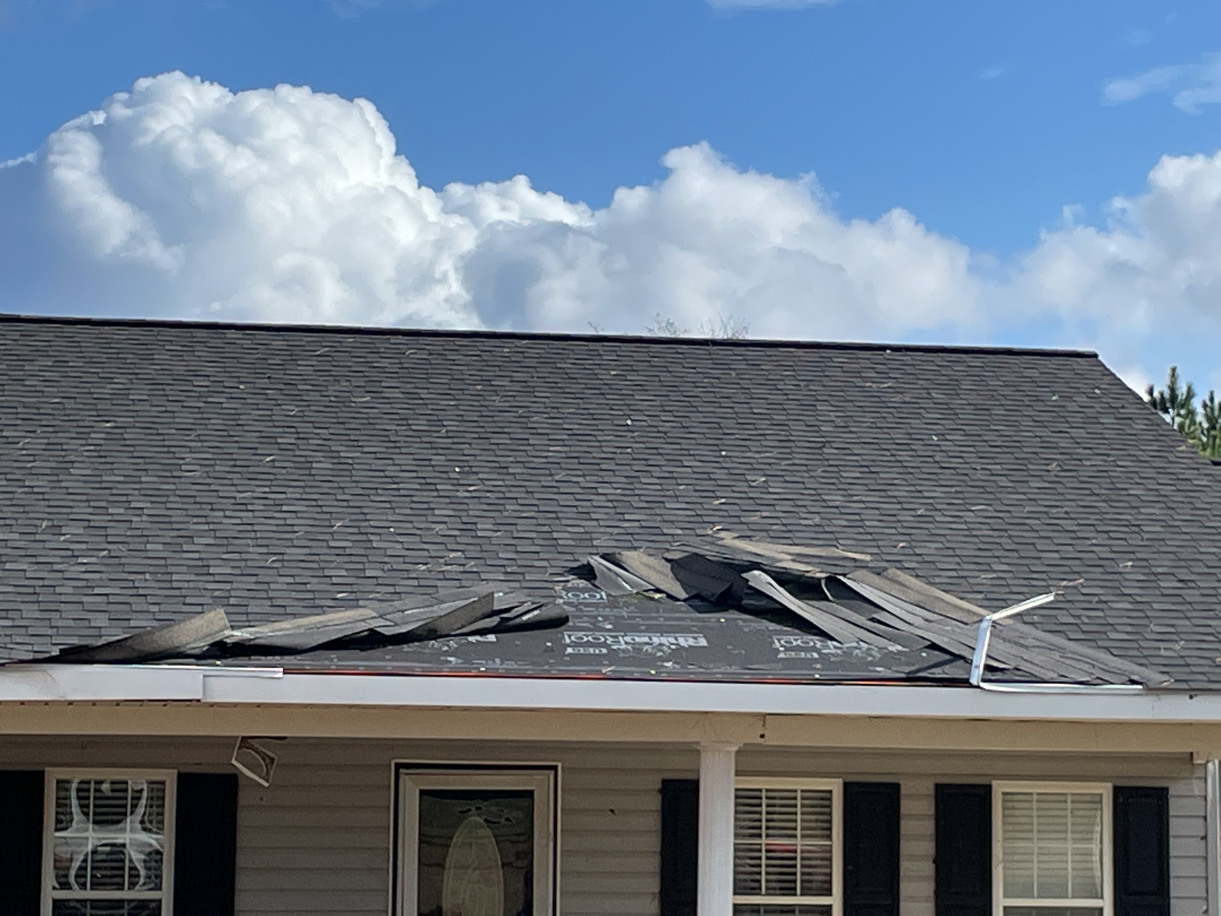
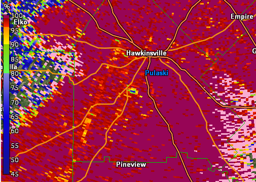
This tornado touched down shortly after entering Pulaski County and began uprooting several trees on Mock Springs Road. Traveling eastward, light damage was observed through several dirt roads, including a covered awning that was completely destroyed on Fire Road 624. The tornado continued eastward, crossing Highway 27 and Highway 257, where several trees were snapped and uprooted and minor damage was done to several homes which included removed vinyl siding, vinyl siding pierced by tree branches, removed gutters and shingles, and damage to a front porch awning. As the tornado crossed near Wallace, an open barn with sheet metal roofing was also destroyed south of the Big Creek bridge on Highway 129. The tornado then moved across a swampy undeveloped area and maintained a TDS signature until passing over the Ocmulgee River, approximately 5 miles south of Hawkinsville. The tornado then dissipated over the wetland with no reported damage on the eastern side.
|
|
|
|
|
| Minor shingle damage occurred on this home. | This open corrugated metal barn received substantial damage. |
|
|
 |
| Reflectivity (6:16 PM EST). | Velocity (6:16 PM EST). |
|
|
| Correlation Coefficient (CC) (6:16 PM EST). |
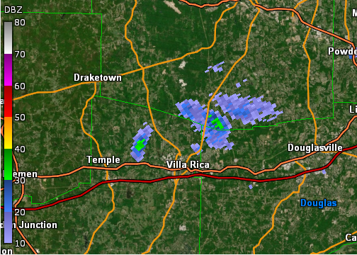
A tornado from a rare LP (low-precipitation) supercell touched down near US-78 between Temple and Villa Rica in far northern Carroll County during the late afternoon/early evening hours of New Year's Eve. Initially, several trees were noted snapped or uprooted between Wilton Smith Road to Old Villa Rica Road. As the tornado moved northeast, it appeared to strengthen as more numerous trees were seen either uprooted or snapped along Long Branch Road and across Cown Road. The number of large pines uprooted along Long Branch Road supports an EF-1 rating here with max winds around 90 mph. On the east side of Long Branch Road and just before Cown Road, a barn was ripped apart along with a carport seen detached from a well-built manufactured home that remained intact. This damage, along with the surrounding tree damage, supported 95 mph max winds (still an EF-1 rating). As the tornado crossed Cown Road and then Astin Creek Road, additional large pines were snapped or uprooted. A home sustained roof damage due to a falling tree, and a medium-sized shed was rolled up on the side of the house about 20 yards from its original location. A few more trees were seen snapped or uprooted along North Van Wert Road, just south of Wert Road, where the tornado appeared to weaken and eventually lift just past this location as no notable damage was reported or seen.
|
|
|
|
|
| This carport detached from the adjacent home and collapsed. | A large number of trees were downed at this location, several of which crushed a building and vehicles. |
|
|
 |
| Reflectivity (5:42 PM EST). *Note the very limited reflectivity of this low-precipitation supercell. | Velocity (5:42 PM EST). |
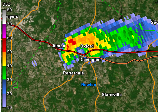
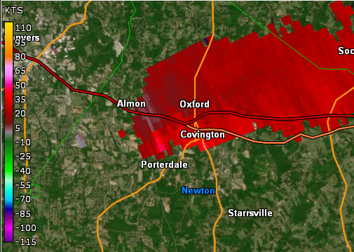
An isolated supercell thunderstorm developed during the late afternoon hours December 31, 2021 in southeast Newton County. A tornado quickly developed from that thunderstorm and first touched down along Creekside Lane just east of Brown Bridge Road where a few trees were snapped. Both video evidence and ground surveys suggest the tornado was sporadic in its contact with the ground as evident by small gaps in damage, particularly in the beginning of the track. The tornado continued east-northeast just along Brown Bridge Road, snapping a few trees and blowing down a fence along Glynshire Court and Roberts Road. The tornado reached peak intensity of 90 mph as it hit Veterans Middle School, removing significant amounts of siding and roofing from the gymnasium as well as sections of the roof. The tornado crossed Slades Mill Court, uprooting trees and causing minor damage to two homes before entering the intersection of Brown Bridge Road and Salem Road. Several trees were uprooted in a Publix parking lot, and minor damage occurred to the roof at Publix. The tornado then crossed through a Chick-Fil-A parking lot where two cars were tossed 100 feet and flipped, and the glass door to the restaurant was shattered. The tornado continued east where minor roof damage occurred to ten homes along Tulip Poplar Way and Mary Jane Lane before the tornado lifted in or around Shiver Boulevard. Six minor injuries were reported near the Chick-Fil-A.
|
|
|
|
|
| Two vehicles were flipped when the tornado crossed this Chick-Fil-A parking lot. Six people received minor injuries. | Veterans Middle School received significant siding and roofing damage in the tornado. |
|
|
| The large rotating wall cloud that produced the tornado can be seen here. |
|
|
 |
| Reflectivity (8:30 PM EDT). | Velocity (8:30 PM EDT). |
The potential for additional strong to severe thunderstorms increased late January 1st through January 2nd as a strong cold front pushed into the state. Record-breaking warmth was in place on January 1st with all four climate sites (Atlanta, Athens, Macon and Columbus) recording the warmest New Year's Day on record. Fortunately, the majority of the severe weather occurred to the northwest and southeast of the local area. However, several reports of damaging wind gusts did occur with the strongest thunderstorms.
Severe Outlooks and Reports:
January 1 SPC Outlook & Storm Reports:

January 2 SPC Outlook & Storm Reports:

An end to the unseasonable warmth finally came by January 3rd. However, this change came alongside a strong low pressure system which brought strong, gusty winds to much of north Georgia as well as light to moderate snowfall totals to portions of the north Georgia mountains. The highest snowfall totals ranged as high as 2-4" in the highest elevations of the north Georgia mountains. Elsewhere, very light snow showers or snow flurries were observed across other areas of north Georgia. Wind gusts reached as high as 50 mph during the early morning hours of January 3rd, bringing down a number of trees and causing scattered power outages.
Observed Snowfall Totals -- January 2 - 3:

Observed Wind Gust Graphs: