Peachtree City, GA
Weather Forecast Office
Madison County EF-1 Tornado
|
|
An EF-1 tornado developed out of a supercell storm which occurred in the afternoon hours of May 3, 2021. An NWS survey found tree damage beginning just east of Highway 106 near the Neese community along Willis Glenn Road. The tornado continued east northeast, crossing Sanders Road and Stone Creek Drive where several trees, both hardwood and pine, were snapped or uprooted along the road and in yards. The tornado continued east, crossing Scogin Road where a home sustained minor roof damage and numerous trees were snapped or uprooted including one on a home at the intersection of Buddy Moore and Scogin Roads. The storm continued northeast, crossing Strickland Circle where several trees were downed, including one onto a home. Farther northeast, the storm crossed Moons Grove Church Road, snapping and uprooting numerous trees, including one on an outbuilding and all around a home nearby. The storm passed through the end of Kellogg Drive before crossing Highway 29 where several trees were snapped, including one onto a portion of another home. The storm continued crossing Mariah Church Road and Christmas Circle where a home had a large tree downed through it and two outbuildings were destroyed along with numerous trees downed or snapped. The tornado lifted as it approached Colbert Grove Church Road.
 |
|
| A number of trees were uprooted in the tornado. | This tree was downed. |
|
|
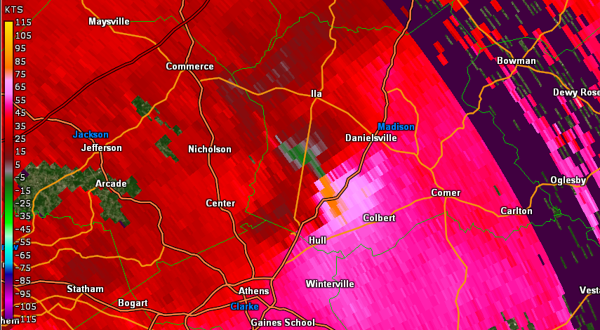 |
| KFFC Reflectivity (12:55 PM EDT) | KFFC base velocity (12:55 PM EDT) |
Current Hazards
Georgia Road Conditions
Nationwide
Local Storm Reports
Local
Submit Storm Report
Outlooks
Forecasts
Local
Computer Models
Graphical
Aviation Weather
Activity Planner
Recreational Forecast
Fire Weather
Forecast Discussion
Incident Support
Tropical Weather
Current Weather
Satellite Images
Observations
Maps
Rivers/Lakes
Radar Imagery
Nationwide
Warner Robins
Peachtree City
Regional Loop
US Dept of Commerce
National Oceanic and Atmospheric Administration
National Weather Service
Peachtree City, GA
4 Falcon Drive
Peachtree City, GA 30269
770.486.1133
Comments? Questions? Please Contact Us.


