April 19, 2019 Severe Weather & Heavy Rainfall:
A strong storm system brought heavy rainfall and severe thunderstorms to much of north and central Georgia on Friday, April 19, 2019. Three tornadoes were confirmed--one EF-0 and two EF-1. Additional scattered wind damage occurred as these thunderstorms traversed the area during the morning hours. An axis of very heavy rainfall occurred during this time as well, leading to flash flooding issues for a number of areas. This swath received widespread 3 to 5 inch rainfall totals with locally higher amounts over 6 inches.
Tornadoes
Heavy Rainfall
Storm Report Map:
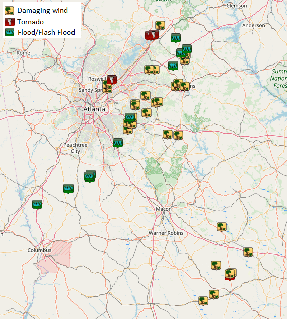 |
| In addition to the three brief tornadoes, damaging wind reports and flash flooding were both a problem. |
Tornadoes:
1) Fulton County (Johns Creek) (EF-0)
2) Hall County (EF-1)
3) Laurens County (EF-1)
Back to Top
1) Fulton County (Johns Creek) Tornado:
A brief tornado touched down in the city of Johns Creek near Royal Lytham Court where large brances were snapped off of trees. The tornado then moved northeast, downing a large tree near the intersection of Prestwick Club Drive and Royal Birkdale Court. Shortly after, the tornado crossed Old Alabama Road where a few trees were snapped and several power poles were downed. The tornado then continued northeast towards Perimeter School where additional minor tree/limb damage occurred just before the tornado lifted.
 |
| Damage Path - Fulton County |
|
| County |
Rating |
# of Injuries |
KML |
| Fulton |
EF-0 |
0 |
 |
|
| Rating: |
EF-0 |
| Peak Wind: |
75 mph |
| Path Length: |
0.6 miles |
| Path Width: |
150 yards |
| Fatalities: |
0 |
| Injuries: |
0 |
| Start Date: |
April 19, 2019 |
| Start Time: |
5:07 AM EDT |
| Start Location: |
1.3 miles SW of Johns Creek |
| Start Lat/Lon: |
34.0078 / -84.2014 |
| End Date: |
April 19, 2019 |
| End Time: |
5:08 AM EDT |
| End Location: |
0.8 miles SW of Johns Creek |
| End Lat/Lon: |
34.0149 / -84.1962 |
|
|
|

|
 |
| Several large utility poles were downed by the tornado on Old Alabama Road. (courtesy: Johns Creek Police) |
Several trees were uprooted along the tornado's brief path. |
Back to Top
2) Hall County Tornado:
A short-lived tornado embedded within a line of heavy showers and thunderstorms touched down over northern Hall County early on the morning of Friday, April 19, 2019 about 8 miles north of Gainesville. Much of the damage within the tornado path was snapped and uprooted trees. There was some structural damage, including at Dewberry Baptist Church, where the steeple was blown over. Pockets of stronger winds approaching 90 mph occurred on either side of Highway 284 along Nopone Road and Glade Farm Road where numerous large trees were uprooted or snapped about halfway down. The tornado appeared to lift along Glade Farm Road near Flat Creek.
 |
| Damage Path - Hall County |
|
| County |
Rating |
# of Injuries |
KML |
| Hall |
EF-1 |
0 |
|
|
| Rating: |
EF-1 |
| Peak Wind: |
90 mph |
| Path Length: |
2.5 miles |
| Path Width: |
300 yards |
| Fatalities: |
0 |
| Injuries: |
0 |
| Start Date: |
April 19, 2019 |
| Start Time: |
5:50 AM EDT |
| Start Location: |
4.5 miles S of Clermont |
| Start Lat/Lon: |
34.4099 / -83.7783 |
| End Date: |
April 19, 2019 |
| End Time: |
5:53 AM EDT |
| End Location: |
4.4 miles SE of Clermont |
| End Lat/Lon: |
34.42047 / -83.7389 |
|
|
|

|
 |
| The steeple was toppled from this church. |
Numerous trees were snapped or uprooted by the tornado. |
Back to Top
3) Laurens County Tornado:
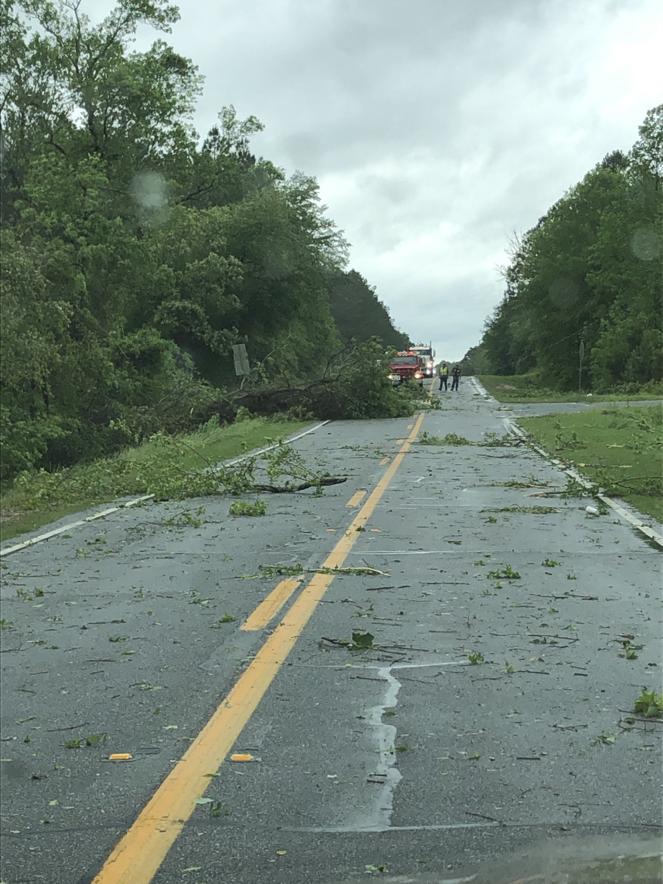
A brief tornado touched down in the southern end of Laurens County along US Highway 319/441 just south of GA Highway 46 and tracked north-northeast, lifting near the intersection of Faulk Road and Oakdale Road, about a mile north of GA Highway 46. Trees were mainly snapped or uprooted along its short path, with the most concentrated damage occurring along Sudie Pearl Jones Road where numerous large trees were snapped or uprooted. This damage supports the maximum estimated winds of 90 mph, giving this tornado an EF-1 rating. A metal roof on a single-story home was partially lifted and thrown at this location as well. Just to the northeast of this area, several large trees took out power lines at the intersection of GA Highway 46 and Faulk Road. Minor tree/limb damage was seen along Faulk Road near Oakdale Road. The tornado lifted just beyond this location as no additional damage was noted.
 |
| Damage Path - Laurens County |
|
| County |
Rating |
# of Injuries |
KML |
| Laurens |
EF-1 |
0 |
|
|
| Rating: |
EF-1 |
| Peak Wind: |
90 MPH |
| Path Length: |
4.6 miles |
| Path Width: |
200 yards |
| Fatalities: |
0 |
| Injuries: |
0 |
| Start Date: |
April 19, 2019 |
| Start Time: |
11:25 AM EDT |
| Start Location: |
10.4 miles N of McRae |
| Start Lat/Lon: |
32.2167 / -82.9119 |
| End Date: |
April 19, 2019 |
| End Time: |
11:30 AM EDT |
| End Location: |
14.6 miles NNE of McRae |
| End Lat/Lon: |
32.2747 / -82.8786 |
|
|
|

|
 |
| Numerous trees were snapped or uprooted by the tornado. |
Trees were downed as the tornado crossed this highway. |
Back to Top
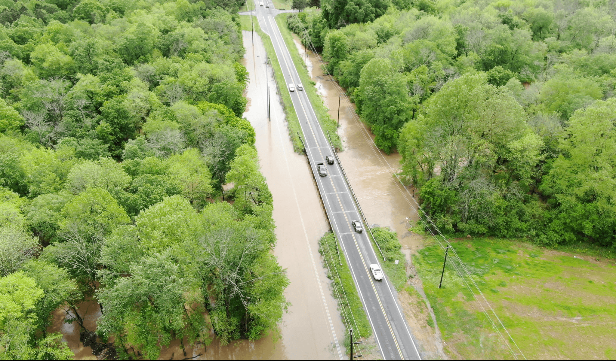
Heavy Rainfall:
 |
| A swath of very heavy rainfall fell over the period of a few hours Friday morning across north Georgia. In some areas, amounts over 6" occurred leading to flash flooding. |
|

|
 |
| Waterways turned into raging rivers, including here in Clayton County. |
Many roads were washed out due to flash flooding, including Bill Taylor Road in Troup County. |
|
|
 |
| Flooding in Clayton County. |
Flooding in Clayton County. |

