April 14, 2019 Severe Weather Event:
Tornadoes:
1) Phenix City, AL/Columbus, GA (EF-0)
2) Muscogee/Harris/Talbot Counties (EF-0)
3) Lamar County (EF-0)
4) Lamar/Spalding Counties (EF-1)
1) Phenix City, AL / Columbus, GA Tornado:
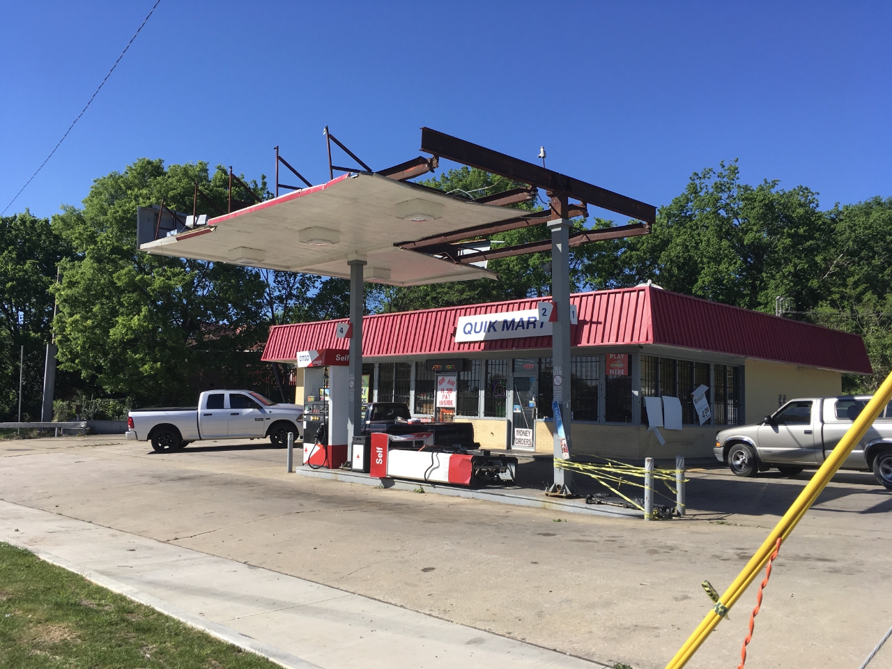
A weak tornado embedded within a line of severe thunderstorms began at the Phenix City Water Treatment Facility where several uprooted and snapped trees were observed along with substaintial roof damage to the facility headquarters. It then moved north-northeast along State Docks Road before moving across the Chattahoochee River. The tornado crossed the Chattahoochee River between Rotary Park and 22nd Avenue, snapping a few tree limbs between Victory Drive and Blanchard Boulevard. The short-lived tornado traveled nearly due north, damaging a metal roof/awning and knowcking out several gas pumps at a gas station off Martin Luthing King Jr Boulevard in the Avondale community. Metal panels were pulled off a 1-story metal warehouse building off Cusseta Road, just south of the gas station. Maximum winds at this location were likely between 70-80 mph. Moving just north, a large tree was uprooted and took out some power lines along 17th Street, just west of Wildwood and Weracoba Parks. This was the last of the damage seen, and the tornado lifted just beyond this location.
.png) |
| Damage Path - Russell County, AL & Muscogee County |
|
| County |
Rating |
# of Injuries |
KML |
| Russell, AL / Muscogee |
EF-0 |
0 |
 |
|
| Rating: |
EF-0 |
| Peak Wind: |
85 mph |
| Path Length: |
3.2 miles (~2.5 miles in GA) |
| Path Width: |
50 yards |
| Fatalities: |
0 |
| Injuries: |
0 |
| Start Date: |
April 14, 2019 |
| Start Time: |
9:09 AM CDT (10:09 AM EDT) |
| Start Location: |
Parker Rd (Phenix City, AL) |
| Start Lat/Lon: |
32.4320 / -84.9714 |
| End Date: |
April 14, 2019 |
| End Time: |
10:23 AM EDT |
| End Location: |
Midtown Columbus, GA |
| End Lat/Lon: |
32.4788 / -84.9702 |
|
|
|

|
 |
| This warehouse on Cusseta Rd lost a portion of its roof. |
The gas pumps and part of the gas station awning were destroyed by the tornado on Martin Luther King Jr Blvd. |
2) Muscogee/Harris/Talbot Counties Tornado:
An EF-0 tornado first touched down in extreme northern Muscogee County near the county line in a neighborhood along Deerwood Court, snapping a few pine trees. One home sustained minor shingle damage. The tornado continued northeast, crossing McKee Road and Boyd Court, snapping approximately a dozen trees before passing through an uninhabited area near Randall Creek. This location is where NWS doppler radar first detected a debris signcature. The tornado continued northeast, crossing Ridgeway Road, where it struck a hunting camp and rolled two small trailers. Farther northeast, the tornado crossed Highway 315 near the Talbot and Harris County line, also intersecting the path of the long-track tornado from March 3, 2019. The storm continued northeast, crossing County Road 71, where approximately a dozen trees were snapped or uprooted. The tornado finally dissipated north of Culpepper Road and south of Route 208.
 |
| Damage Path - Muscogee/Harris/Talbot Counties |
|
| County |
Rating |
# of Injuries |
KML |
| Muscogee/Harris/Talbot |
EF-0 |
0 |
|
|
| Rating: |
EF-0 |
| Peak Wind: |
80 mph |
| Path Length: |
8.5 miles |
| Path Width: |
100 yards |
| Fatalities: |
0 |
| Injuries: |
0 |
| Start Date: |
April 14, 2019 |
| Start Time: |
10:46 AM EDT |
| Start Location: |
4.4 miles E of Midland, GA |
| Start Lat/Lon: |
32.5795 / -84.7448 |
| End Date: |
April 14, 2019 |
| End Time: |
10:55 AM EDT |
| End Location: |
7 miles W of Talbotton, GA |
| End Lat/Lon: |
32.6795 / -84.6615 |
|
|
|

|
 |
| This home received minor roof damage. |
These trees were snapped in the tornado. |
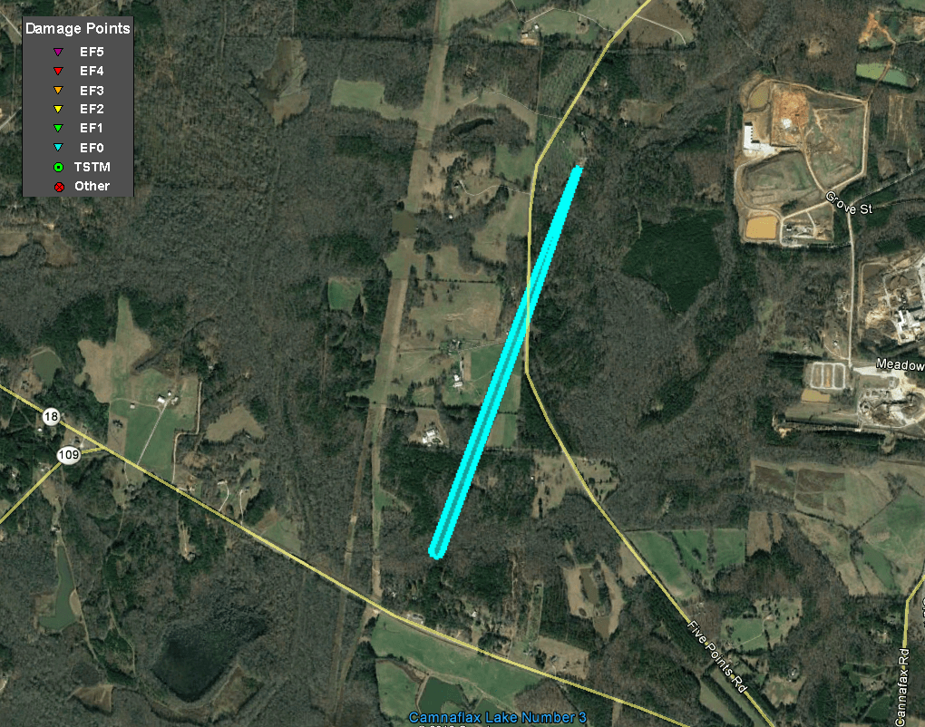
3) Lamar County Tornado #1:
The same storm responsible for the tornado in Muscogee/Harris/Talbot counties regenereated a brief tornado in western Lamar County north of HIghway 18 and along Five Points Road. Several trees were snapped or uprooted. A few power lines were also downed along the short path. The tornado lifted before reaching Zebulon Road west of the town of Milner.
 |
| Damage Path - Lamar County |
|
| County |
Rating |
# of Injuries |
KML |
| Lamar |
EF-0 |
0 |
|
|
| Rating: |
EF-0 |
| Peak Wind: |
75 MPH |
| Path Length: |
1.1 miles |
| Path Width: |
75 yards |
| Fatalities: |
0 |
| Injuries: |
0 |
| Start Date: |
April 14, 2019 |
| Start Time: |
11:39 AM EDT |
| Start Location: |
3.6 miles SW of Milner, GA |
| Start Lat/Lon: |
33.0686 / -84.2245 |
| End Date: |
April 14, 2019 |
| End Time: |
11:42 AM EDT |
| End Location: |
2.5 miles SW of Milner, GA |
| End Lat/Lon: |
33.0842 / -84.2187 |
|
|
|

|
| These trees sustained damage in the weak tornado. |
4) Lamar/Spalding County Tornado:
The same supercell storm responsible for tornadoes in Muscogee/Harris/Talbot counties and previously in Lamar County spawned a third tornado (second in Lamar County). This tornado touched down near the intersection of Weldon Lake Road and Silver Dollar Road where several trees were snapped. Additionally, trees were snapped and uprooted along Weldon Lake Road to the northeast. Numerous trees were snapped along Evans Road, including one large tree that fell onto a carport. A house next to the carport sustained minor shingle damage. The tornado continued northeast, intensifying as it hit the Morgan Dairy Golf Course, where over 50 trees were snapped or uprooted. Numerous trees were snapped or uprooted as the tornado crossed Morgan Dairy Road, at which point peak winds were estimated to have occurred. The storm hit a tree line north of Morgan Dairy road, snapping the trees in a 150 yard wide swath. The storm crossed McKneely Road, snapping trees and power lines, before crossing into Spalding County. A few trees were snapped along Swint Road and Ellis Dairy Road before the tornado weakened and dissipated.
 |
| Damage Path - Lamar/Spalding Counties |
|
| County |
Rating |
# of Injuries |
KML |
| Lamar/Spalding |
EF-1 |
0 |
|
|
| Rating: |
EF-1 |
| Peak Wind: |
90 MPH |
| Path Length: |
4.4 miles |
| Path Width: |
150 yards |
| Fatalities: |
0 |
| Injuries: |
0 |
| Start Date: |
April 14, 2019 |
| Start Time: |
11:45 AM EDT |
| Start Location: |
1.7 miles NNE of Milner, GA |
| Start Lat/Lon: |
33.1380 / -84.1843 |
| End Date: |
April 14, 2019 |
| End Time: |
11:54 AM EDT |
| End Location: |
3.6 miles E of Orchard Hill, GA |
| End Lat/Lon: |
33.1923 / -84.1472 |
|
|
|

|
 |
| Many trees were snapped or uprooted along Morgan Dairy Road. |
More trees were downed along this field edge. |

