April 5, 2017 Tornado Event:
[Overview]
Tornadoes of April 5, 2017:
(in chronological order by county)
| (1) Coweta | (3) Randolph/Stewart/Webster | (5) Dooly | (7)Laurens/Treutlen |
| (2) Newton / Walton | (4) Sumter | (6) Dodge |
Event Overview:
Numerous thunderstorms developed in several waves across the region on April 5, 2017 ahead of a strong springtime storm system. These thunderstorms produced large hail, gusty winds, heavy rainfall, as well as 7 tornadoes in the NWS Atlanta forecast area. The strongest tornadoes were rated EF-2 on the Enhanced Fujita scale and were spawned by the same long-lived supercell that traversed across central Georgia. In addition to the tornadoes, heavy rainfall led to flash flooding incidents, primarily in the Atlanta metro area where some locations received over 4" of rainfall.
|
|
 |
|
Surface map (2 pm, 04/05/2017) A strong system approaching the area spawned several waves of thunderstorms that affected north and central Georgia. |
Effective Bulk Shear (3 pm, 04/05/2017) Effective bulk shear values of 60-70 knots were conducive to rotating thunderstorms capable of producing tornadoes. |
 |
|
Surface-Based CAPE (12 pm, 04/05/2017) Significant instability existed over central Georgia by the afternoon hours. This contributed to the development of numerous thunderstorms, some of which became supercellular. |
 |
|
|
An initial Tornado Watch was issued for much of the area during the morning hours of April 5th as vigorous thunderstorm development was underway. |
A replacement Tornado Watch during the afternoon hours of April 5th was issued as a PDS (Particularly Dangerous Situation) Tornado Watch given the enhanced potential for strong tornadoes. |
|
|
| Numerous wind, hail, flooding, and tornado reports were received across the area on April 5th. |
Tornadoes:
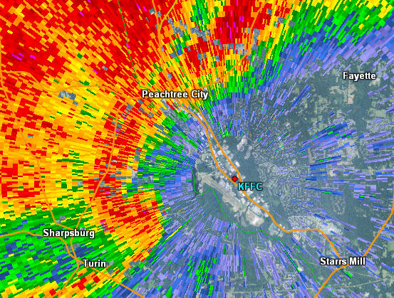
An EF-1 tornado touched down just north of Sharpsburg near Highway 154 and tracked southeast snapping both hardwoods and softwood trees. The greatest damage occurred near Keg Creek and Reese Road where a path of 10 to 15 trees were snapped in various directions. The tornado continued eastward until it lifted near the intersection of Christopher Road and McIntosh Trail.
|
|
|
|
 |
| The primary damage caused by this tornado was tree damage. | A number of trees were snapped at this location. |
|
|
 |
| Reflectivity (12:07 PM EDT) | Velocity (12:07 EDT) |
A low-end EF-1 tornado touched down near the far northern Newton County/southwestern Walton County line where it did the most damage along Wapakoneta Trail. Multiple softwood trees were snapped and uprooted with one causing vehicle damage. The tornado continued eastward into Walton County before weakening and lifting near Harris Rockmore Road.
|
|
|
|
 |
| This home suffered roof damage in the tornado. | Many trees were downed in the tornado. |
|
|
 |
| Reflectivity (12:09 PM EDT). | Velocity (12:09 PM EDT). |
Note...This is a joint statement from WFO Tallahassee and WFO Peachtree City covering the surveys of the long-track tornado which was on the ground from Randolph County to Webster County Georgia.
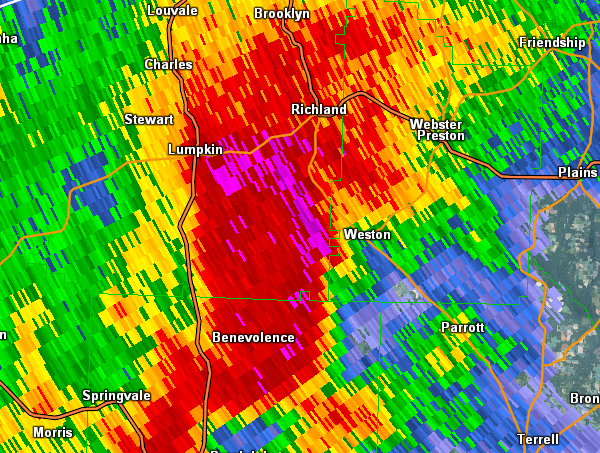
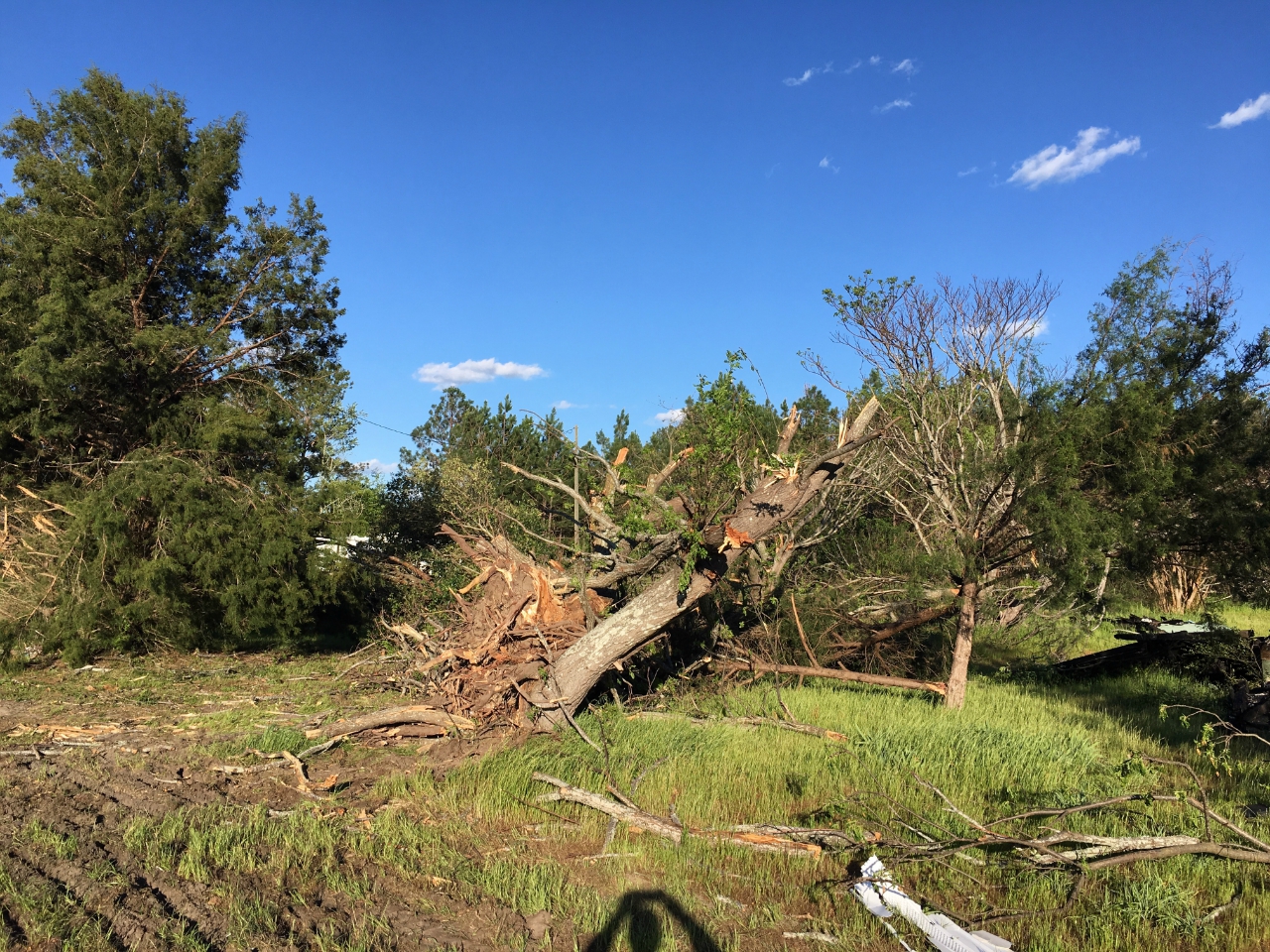
The tornado touched down near the Randolph-Stewart County line was produced by the same supercell that spawned the tornado that impacted Henry and Barbour Counties in Alabama and Quitman County in Georgia. Fortunately most of the tornado's path was through forests and farm land, limiting the number of homes and businesses that were damaged. The majority of damage was rated EF1, but there were a couple of locations with EF2 damage. The tornado touched down in extreme northwest Randolph County at EF1 strength. The tornado then traveled across southeast Stewart County. About 5 miles west of Weston, but still in Stewart County, GA, was where the observed EF2 damage occurred. It was here that the number of downed trees, both hard and soft wood, increased in a half-mile swath. Some of the trees were uprooted while most were snapped at the trunk, including trunks with diameters of 2 feet. Two chicken houses were also destroyed. Near the chicken houses was a small trailer park. Two of the trailers suffered EF1 roof damage. One of the trailers was largely destroyed, but not moved from its foundation. The car next to it was not moved either. Therefore it was determined to be high-end EF1 damage, and not EF2 damage. The tornado path continued into Webster County, and ended about 2 miles east of the small town of Weston. The damage in the area ranged from EF0 to EF1, and was mostly to trees, power lines, and small farm outbuildings. One peanut farm storage building next to the highway was destroyed...fortunately the employees had been sent home at 11am due to the threat for severe weather that day. The owner had left minutes prior as a result of receiving a phone call stating that Weston was in the path of the storm. The tornado lifted east of town near the intersections of Hudson Leverette Rd and County road 23.
|
|
|
|
 |
| A large swath of trees was snapped or uprooted along the tornado's path in Stewart County. | These farm buildings in Stewart County were destroyed by the EF-2 tornado. |
|
|
 |
| Reflectivity (12:37 PM EDT) | Velocity (12:37 PM EDT) |
 |
| The blue area in the Correlation Coefficient (CC) product indicates the presence of debris lofted in the air by the tornado (12:37 PM EDT) |
An EF0 briefly touched down southwest of the town of Plains GA along GA-45 snapping a few trees. The tornado continued NE crossing N. Carter Fishpond Rd and Chavers Dr uprooting a few trees. The tornado crossed GA308 south of plains uprooting few trees and causing minor roof damage to a few homes. The tornado weakened shortly after crossing Wise Road.
|
|
|
|
 |
| This large tree was split in the winds of the Plains-area tornado. | Most of the damage associated with this weak tornado was to trees. |
|
|
 |
| Reflectivity (1:11 PM EDT) | Velocity (1:11 PM EDT) |
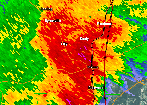
A strong EF1 tornado touched down in far western Dooly county south of US27 and west of Franklin road. The most substantial damage occurred to a home along Franklin road where the 2nd floor was completely destroyed. Investigating the construction of the home revealed that it was poorly constructed and still in the finishing stages of construction thereby weakening the walls thus the rating was kept at EF1 versus EF2. Tree damage was noted in the area around the home and a large crop irrigation system was flipped over in a nearby field. The tornado continued NE crossing US 27 just east of where Ayers Road intersects and several trees were snapped and uprooted where it crossed. The tornado continued ENE and crossed Slosheye Trail where hundreds of trees were snapped and uprooted in a wooded area on either side of the road. Notably, the strongest rotation on radar was noted at this location. As the tornado continued to the NE it crossed GA-90 snapping a couple of trees before weakening east of Pleasant Valley Road.
|
|
|
|
 |
| The upstairs portion of this home, which was undergoing construction and was not fully built, was removed by the tornado. | This tornado caused significant tree damage along its path. |
|
|
 |
| Reflectivity (2:07 PM EDT). | Velocity (2:08 PM EDT). |
An EF1 tornado touched down West of Hardy Road damaging a few homes as it crossed Hardy Road. The damage was mostly minor roof damage to both homes and storage buildings. Several trees were snapped and uprooted in the area as well. The tornado continued east and as it crossed Garrett Oxley road, it destroyed a travel trailer, a small barn and lofted a metal car covering that was never found. The van that was parked under the covering was turned sideways and left a scar in the ground about 7 feet in length from the tires dragging in the dirt. The tornado entered the NW side of Gresston on Greston Baptist Rd where numerous large pines were snapped and some roof damage to the Baptist Church was noted. Further northeast along Rozar-Goolsby Rd, numerous trees were snapped or uprooted and several homes sustained roof damage. Another church along this street also sustained roof damage. The tornado continued NE snapping and uprooting trees before weakening shortly after crossing Bell Line Road.
|
|
|
|
 |
| The tornado uprooted this enormous tree onto a home. | These trees were no match for the tornado. |
|
|
 |
| Reflectivity (3:06 PM EDT) | Velocity (3:07 PM EDT) |
An EF2 tornado touched down west of Evan Colter Road where a house sustained damage and dozens of trees were snapped and uprooted. The tornado cut down dozens of pines across the street from the home. A large autobody repair shop was destroyed along Coleman Register road along with some damage to nearby homes. Dozens of trees were also snapped in the area. The tornado crossed Five Points road snapping trees before clipping a well built new home along Baker Church road. The second floor on the south side of the house was mostly destroyed. Nearby, a large triangle radio antenna tower was completely bent over and several outbuildings were completely destroyed. The tornado continued NE along James Evans road snapping trees and damaging the roofs of homes along the way. The tornado crossed S. Popler Springs Church Road near the intersection of Mayberry road snapping trees along its path crossing Greg Couey Road, Hall Road, Captain Debbie Brown Hwy (19), Rock Springs Rd and eventually going over a marshy area in eastern Laurens county before crossing into Treutlen county. The team could not access the area between Rock Spring Road and GA199 but did find damage along GA 199 and Thairdell Road to trees thus the team is assuming a continuous path through the marshy region based on both the damage and radar presentation. The tornado continued east much weaker crossing into Treutlen county damaging a few trees along Knox Mill road and Red Bluff Church Road before lifting near GA 29 and Briarcliff Road.
|
|
|
|
.jpg) |
| The tornado caused significant EF-2 damage to this well-built home. | This shed lost a portion of it's roof. |
|
|
 |
| Reflectivity (3:41 PM EDT) | Velocity (3:41 PM EDT) |
 |
| The blue area highlighted on the Correlation Coefficient (CC) product indicates lofted debris.(3:42 PM EDT) |