March 1, 2017 Severe Weather Event
A severe weather event unfolded across much of the eastern part of the United States on March 1, 2017 as a strong storm system pushed eastward. In north Georgia, the ingredients were in place for some severe thunderstorms. With very warm temperatures across the area, there was enough instability for convective development with strong forcing along the approaching cold front. Additionally, steep mid-level lapse rates and sufficient wind shear led to some storms becoming severe. One brief tornado was recorded in north Georgia while many reports of large hail occurred. Some reports of damaging wind gusts also occurred as the storms moved through north Georgia. As the storms moved southward into central Georgia, they weakened substantially with the loss of the best dynamics.
|
|
.png) |
|
|
Surface map (4 pm, 03/01/2017) A strong cold front approaching the region sparked thunderstorms in the very warm air mass that preceded it. Atlanta reached a record high of 80° F. |
700-500 mb Lapse Rates (5 pm, 03/01/2017) Steep mid-level lapse rates over 7 °C/km supported the threat for large hail. |
.png) |
|
0-1 km storm relative helicity (SRH) map (4 pm, 03/01/2017) SRH values over 200 m^2/s^2 were supportive of the possibility of a few tornadoes in far north. |
|
|
|
|
A Tornado Watch was issued for much of far north Georgia as thunderstorms approached. |
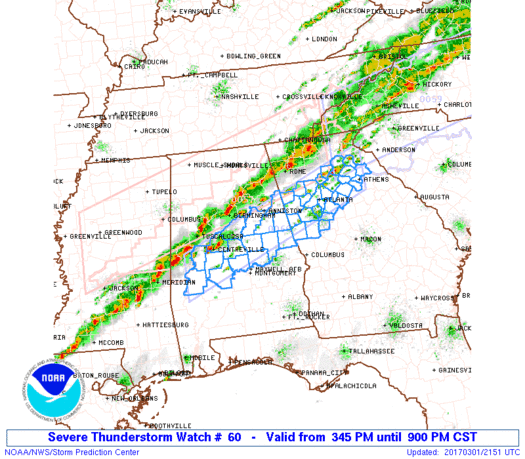
A Severe Thunderstorm Watch was issued for much of north Georgia, including metro Atlanta, by the evening. |
|
|
| Storm Reports from March 1, 2017 |
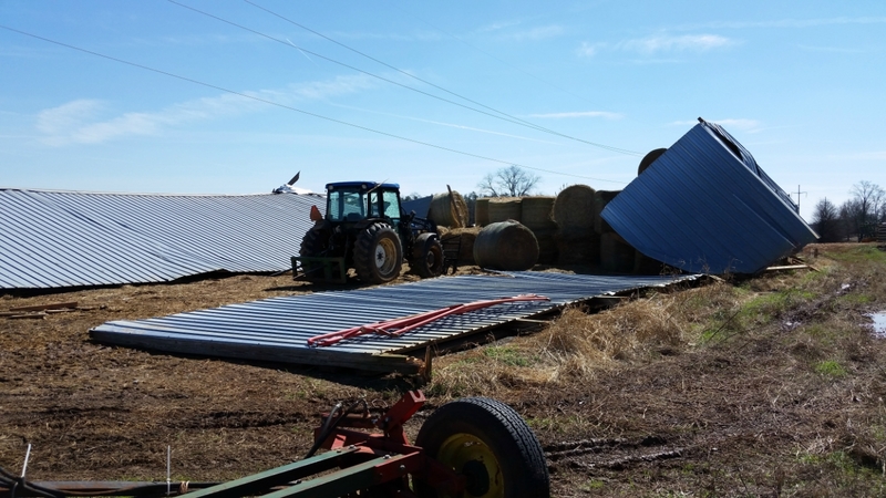
An EF-1 tornado touched down just west of the city limits of Chatsworth (just east of GA-225) destroying a barn along Dogwood Circle. The tornado tracked east, hitting a tractor trailer storage facility along Lowy Road where a semi trailer was overturned. Numerous trees were snapped and uprooted in the area as well. The tornado continued east, hitting an industrial building at the intersection of Highland Road and Treadwell Road where large sections of the roof were peeled back. An apartment complex across the street sustained significant shingle damage and some minor roof structure damage. The tornado continued east along Keller Drive where trees were snapped and uprooted. At this point the tornado impacted a school along Green Road and Old Dalton Ellijay Road. The tornado caused significant damage to the baseball fields where the fence and a cinderblock wall were blown down. Additionally, the bleachers were thrown onto the field and the press box was damaged. The tornado continued to the ESE, crossing West Chestnut Street in Chatsworth where trees were snapped and uprooted. A fence was blown down and a carport collapsed onto a car in this area as well. The tornado weakaed and lifted as it crossed US Highway 411, which runs north-south through Chatsworth. The majority of the damage along the path was considered high-end EF-0 damage associated with winds of 80 to 85 mph. The damages to the barn and to the baseball field were slightly greater and justify the low-end EF-1 rating.
|
|
|
|
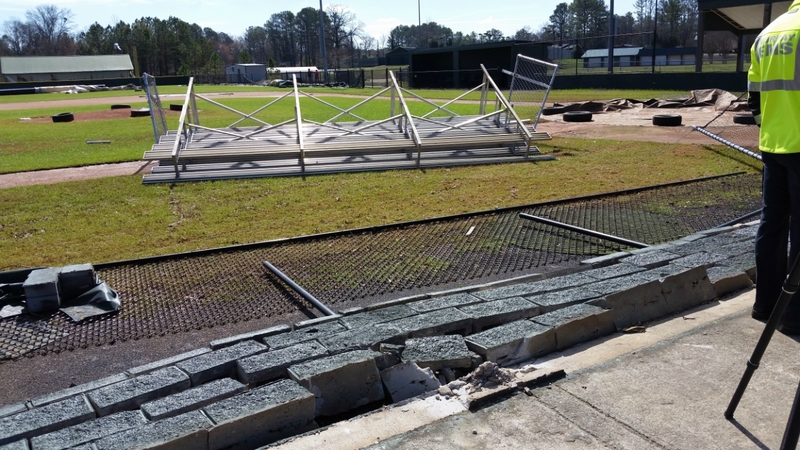 |
| This barn west of Chatsworth collapsed in the tornado. | The bleachers were blown into the field at this baseball field off Old Dalton Ellijay Rd in Chatsoworth. Fence and press box damage also occurred. |
|
|
 |
| Reflectivity from KFFC (4:29 PM EST). | Velocity from KFFC (4:29 PM EST). |
 |
 |
| The largest hail was reported in Gordon County near Calhoun where golfball sized hail occurred. | Large hail covered the ground in this Gordon County neighborhood. |