January 21 - 22, 2017 Tornado Outbreak
[Overview]
Tornadoes of January 21, 2017:
(in chronological order by county)
| (1) Troup | (9) Upson #5 | (17) Laurens |
| (2) Harris | (10) Macon | (18) Baldwin / Hancock |
| (3) Talbot | (11) Monroe | (19) Johnson |
| (4) Talbot / Upson #1 | (12) Peach / Houston | (20) Washington #1 |
| (5) Taylor | (13) Twiggs | (21) Washington #2 |
| (6) Talbot / Upson #2 | (14) Bleckley | (22) Washington #3 |
| (7) Upson #3 | (15) Wilkinson | (23) Emanuel |
| (8) Upson #4 | (16) Putnam |
Tornadoes of January 22, 2017:
(in chronological order by county)
| (1) Dougherty to Wilcox |
| (2) Crisp |
| (3) Bleckley #1 |
| (4) Bleckley #2 |
|
|
|
Tornado Tracks - January 21 & 22, 2017 (41 tornadoes across Georgia) |
A powerful storm system approached the area from the west Saturday, January 21st and moved across the state Sunday afternoon, January 22nd. A line of storms known as a quasi-linear convective system (QLCS) associated with a strong shortwave produced numerous tornadoes and caused extensive damage across central Georgia on Saturday. Another round of tornadic weather affected southern and central Georgia on Sunday ahead of the main upper-level low pushing through the Southeast U.S.
These two severe weather events produced 27 tornadoes across the NWS Atlanta area, which is the highest number of tornadoes recorded in a two-day period in the County Warning Area since reliable records began in 1950. This beats the old record of 16 tornadoes from August 29, 2005.
41 tornadoes were recorded across the state of Georgia during the two day period, which also set a new record for a two-day period, beating the old record of 25 from September 15-16, 2004.
January 21:
|
|
 |
|
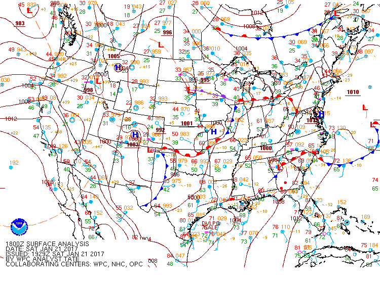
| Surface map (1 pm - Jan. 21) |
0-1 km storm relative helicity (SRH) map (Jan. 21, 12 pm) Favorable SRH led to the formation of numerous tornadoes. |
|
|
 |
|
|
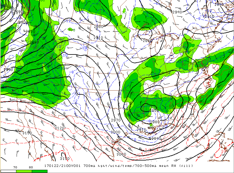
700 mb height/wind/temp (Jan. 21, 11 am) A strong shortwave helped produce numerous thunderstorms. |
Analyzed surface CAPE (Jan. 21, 10 am) The more substantial axis of instability was across central and southern Georgia where the severe weather occurred. |
January 22:
|
|
 |
|
| Surface map (1 pm - Jan. 22) | 0-1 km storm relative helicity (SRH) map (Jan. 22, 4 pm) |
 |
 |
|
|
700 mb height/wind/temp (Jan. 21, 4 pm) Disturbances rotating ahead of a massive upper-level low over the Mississipi Valley helped produce severe weather over Georgia. |
Analyzed surface CAPE (Jan. 22, 4 pm) Tornado-producing supercells developed within the axis of higher instability across southern and central Georgia. |
|
|
|
|
Tornado watch from the afternoon of Jan. 21 |
Particularly Dangerous Situation (PDS) Tornado Watch from the afternoon of Jan. 22 |
January 21st Tornadoes:
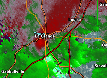
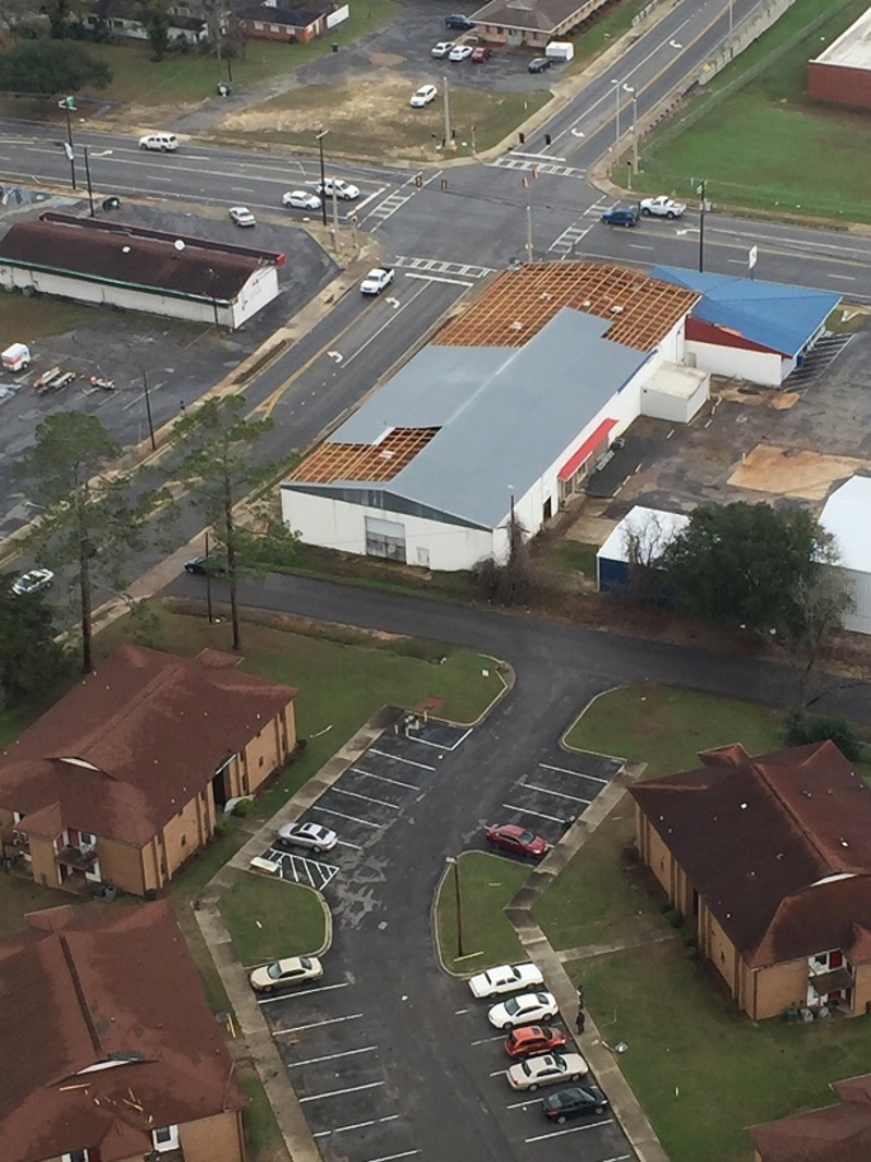
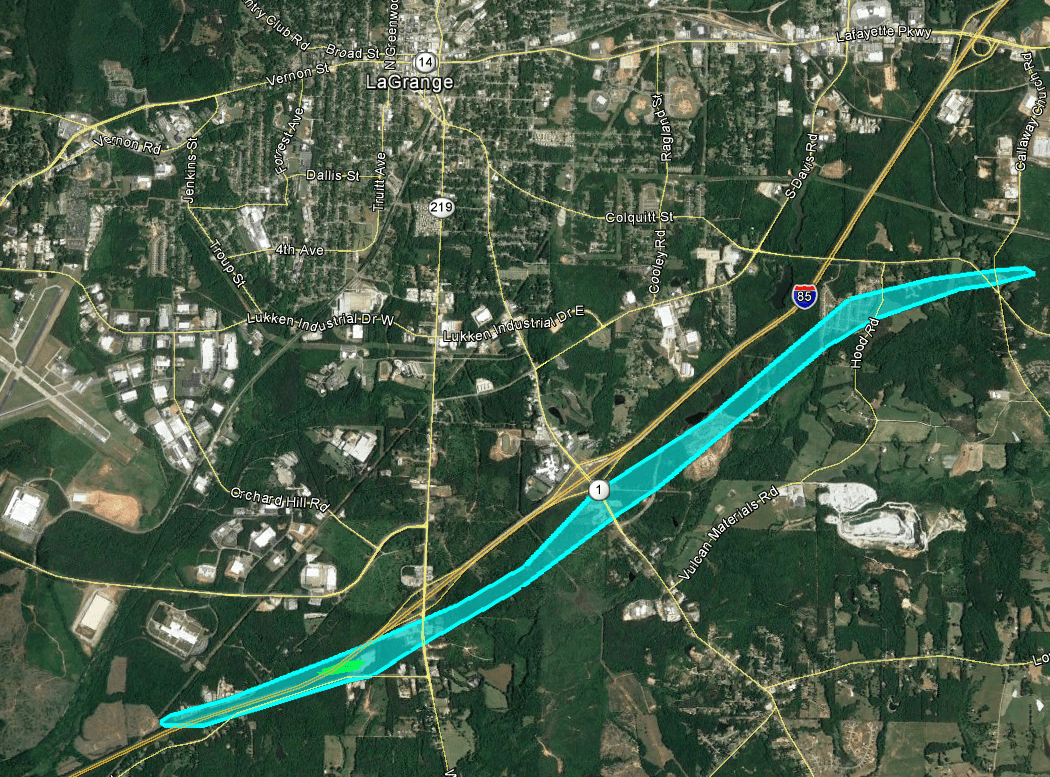
A tornado touched down just west of I-85 and crossed near mile marker 13, where several trees were snapped and a metal building structure had part of its roof pulled up and its garage door blown in. The tornado continued its track northeast with additional damage around the Wal-mart Distribution Center, near LaGrange. Several trees were uprooted in this area. The tornado lifted around Upper Springs Road.
|
|
|
|
 |
| This industrial building sustained roof and garage door damage. | This home experienced minor roof damage. |
|
|
 |
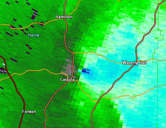
| Reflectivity (8:52 AM EST). | Velocity (8:53 AM EST). |
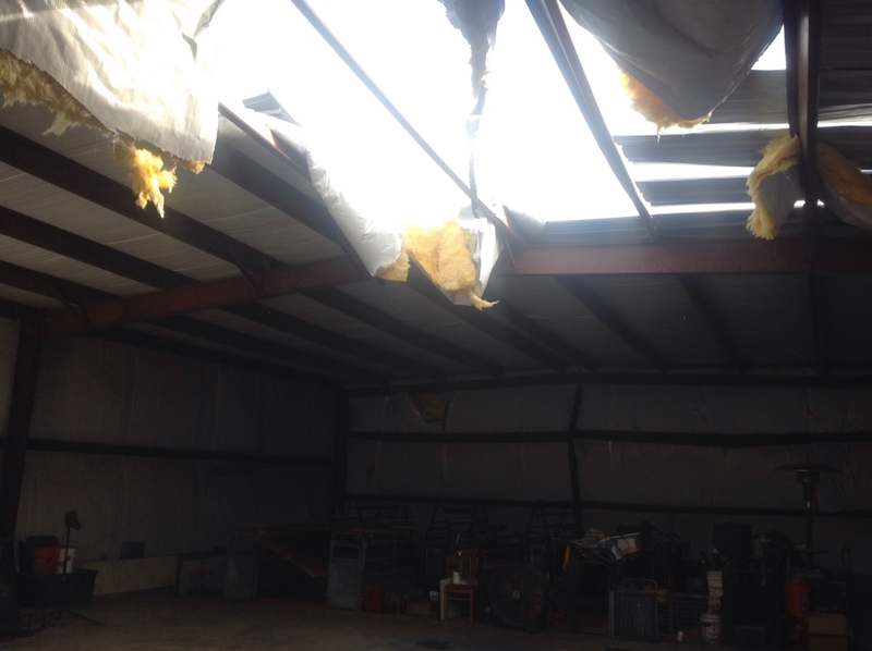
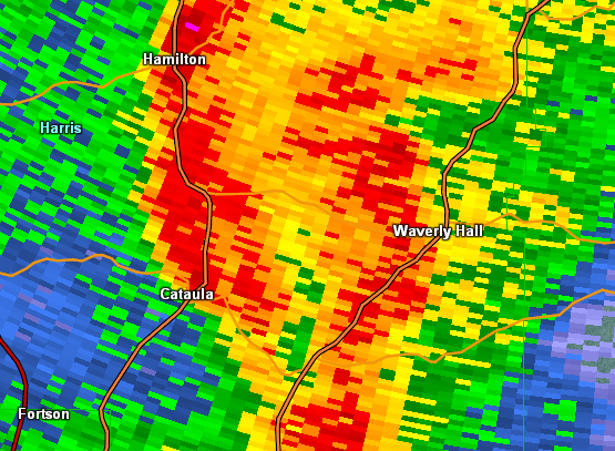
A tornado touched down just northwest of the community of Fortson in southern Harris County. Several homes between Daniel Drive and Gail Drive sustained rather significant roof damage. Winds quickly intensified to around 100 MPH around around this location. Numerous trees were snapped or uprooted along West Bonacre Road toward Grey Smoke Trail. Around Grey Smoke Loop, several homes had roof damage and large trees were uprooted. As the tornado approached the town of Cataula, additional large trees were snapped or uprooted. At Billy's Super Market, 4-6 biscuit cans "popped" likely due to the intense pressure drop/rise from the passing tornado. The tornado lifted just west of Waverly Hall.
|
|
|
|
 |
| The roof on this outdoor covered area was blown off of its supports. | Many trees were uprooted or snapped around this property, and roof damage occurred to the home. |
|
|
 |
| Reflectivity (10:44 PM EST). | Velocity (10:44 PM EST). |
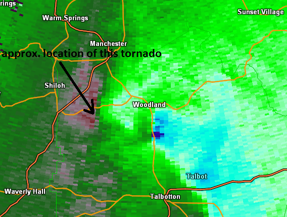
The same storm that produced the tornado in Harris County recycled and produced a short tornado track in North Central Talbot County. The Talbot County Emergency Manager confirms numerous trees snapped in a wilderness area and along Bonnie Dixon Road southwest of Woodland. Additional reports into the Talbot County Emergency Management office included trees down along various paths used for off-road recreation in that vicinity. This area is very wooded and the track is very closely estimated from reports and from radar data.
|
|
|
|
 |
| Reflectivity (11:07 AM EST). | Velocity (11:07 AM EST). |
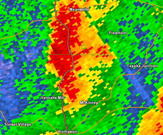
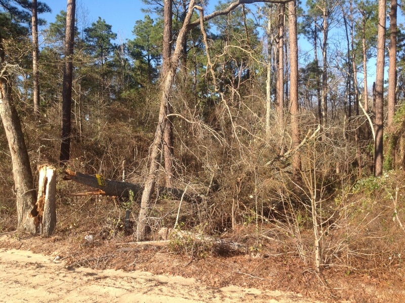
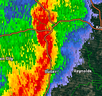
A tornado touched down in Talbot county along Ellison Pound Road and travelled Northeast crossing Chalybeate Springs road snapping and uprooting trees as well as destroying a small shed. A witness near the intersection of Chalybeate Road and hwy 36 reported hearing the tornado pass to his north. The tornado continued northeast through a heavily forested area of northeast Talbot County before passing into Sprewell Bluff Park snapping and uprooting trees along the Flint River and overturning a small building at the park. At this point a second tornado was touching down a few miles to the SE near the Riverbend Restaurant and would travel NE and in front of this storm. This tornado continued east crossing Double Bridges Road where at least 36 trees were downed across the road. The track turned east crossing Roland Road north of hwy 36 damaging a roof to a home and downing trees. The track would cross Hollman Drive and Sunnyside Road which is approximately where this track would cross the Riverbend track which would have passed minutes prior. The exact location of where the two tracks cross is difficult to discern as access west of Sunnyside Road would only be by air. Edits to this track may occur if additional information becomes available. The track ends very near Hwy 36 eat of Roland.
|
|
|
|
 |
| A large pine tree was snapped at this location. | This outbuilding was flipped over. |
|
|
 |
| Reflectivity (11:22 AM EST). | Velocity (11:22 AM EST). |
|
(11:24 AM EST). |
A tornado touched down between Junction City and Butler, in Taylor County. A few trees were snapped north of Butler Highway (Hwy 96). Additional trees were snapped or uprooted along a path that crossed Watson Pond Road, North Culverhouse Road, and Suddeth Road (moving in a northeast direction). Along Wilson Road, two metal barns were destroyed and a small silo was ripped out of the ground and thrown at least 300 yards. Significant roof and gutter damage occurred to a single-story home, along with its windows blown out. It was at this location that the tornado was at its peak intensity of 105 MPH, EF-1 rating. The tornado continued northeast, snapping or uprooting trees. Just northeast of Hwy 19 off Montford Road, a trailer sustained significant roof and siding damage with several large trees snapped or uprooted around its property. The tornado appeared to weaken just beyond this location, lifting somewhere in an open field before CR 108.
|
|
|
|
 |
| This home sustained roof and window damage from the tornado. | This small barn was completely destroyed by the tornado. |
|
|
 |
| Reflectivity (11:29 AM EST). | Velocity (11:29 AM EST). |
|
(11:29 AM EST). |
A tornado touched down in Talbot County just SW of the Riverbend Restaurant on the Flint River. Hundreds of trees were snapped along a wide swath as the storm came over a hill and into the river valley. A home was severely damaged by the river and a person was trapped but not injured. Near the home...hundreds of trees were blown down and snapped within 10 feet of the ground in a swath nearly 300 yards wide. The track continues northeast across the river and parallels Riverbend Road in Upson county snapping trees and downing powerlines. The storm crossed hwy 36 briefly near the intersection of Riverbend road before crossing Roland Road south of hwy 36 snapping trees and damaging a roof on a home. The tornado crossed Hwy 36 again just east of the W. Jefferson Road intersection snapping and uprooting trees. The track continues northeast and crosses Sunnyside road and Hollman roads ahead of Storm #1 snapping and uprooting trees. The track continues north along Sunnyside Road where several homes sustained roof damage and trees were snapped and uprooted. The track eventually crosses Crest hwy and Picard Road where numerous trees were snapped or uprooted. Several homes also sustained minor to moderate roof damage along this portion of the track. The tornado weakened and dissapated after crossing Old Alabama Road.
|
|
|
|
 |
| Hundreds of trees were snapped and uprooted near the Riverbend Restaurant on the Flint River. | Numerous trees were snapped at this location on GA-74. |
|
|
 |
| Reflectivity (11:22 AM EST). | Velocity (11:22 AM EST). |
|
(11:24 AM EST). |
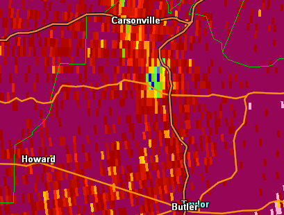
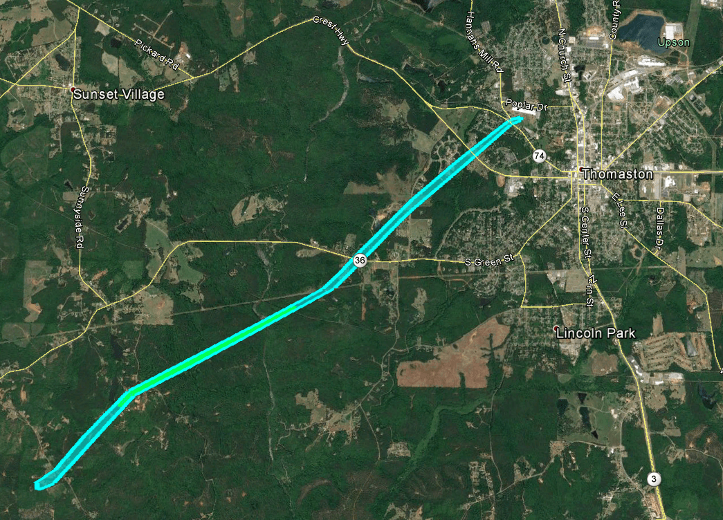
A tornado touched down along Roland Road Southeast of hwy 36 and southeast of Upson storm #2 where a home sustained moderate roof damage. The tornado tracked northeast crossing Hardwood Road where a home sustained significant roof damage and numerous trees were snapped or uprooted and powerlines were downed. The tornado cross Reid Place road snapping trees and continued northeast toward Thomaston. Just south of hwy 36 and west of where Goshen road meets hwy 36...a porch was taken off of a home and trees were uprooted. The tornado continued northeast crossing Peachbelt Road where multiple trees and powerlines were downed and into the West side of Thomaston. The weakening tornado snapped or uprooted a few trees near hwy 74 and along west main street before lifting.
|
|
|
|
.png) |
| Reflectivity (11:32 AM EST). | Velocity (11:32 AM EST). |
A tornado touched down NW of Thomaston where numerous trees were snapped along a path headed NNW starting along Baker Britt Road. The Upson County Emergency Manager reported that a wreck resulting from downed trees occurred along Baker Britt Road. The tornado continued north-northwest, snapping and uprooting trees near homes located to the west of Baker Britt Road. This quick spin up tornado is one of multiple circulations that occurred in Upson County as the longer and larger line of storms moved through.
|
|
|
|
 |
| A number of trees were downed in this wooded area. | The weak tornado blew down a number of trees in this wooded area. |
|
|
 |
| Reflectivity (11:32 AM EST). | Velocity (11:32 AM EST). |
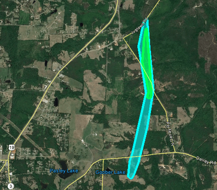
A brief tornado touched down just south of Delray Road and moved northward. The tornado crossed North Delray Road, downing a number of trees and causing minor roof damage to a home. The tornado lifted as it crossed Jugtown Road.
|
|
|
|
 |
| The tornado downed numerous trees at this location. | This home sustained minor roof damage, and trees were also downed on the property. |
|
|
|
| Reflectivity (11:39 AM EST). | Velocity (11:39 M EST). |
10) Macon County Tornado:
A brief tornado touched down SW of Marshallville along Winchester Road tracking to the NE, eventually crossing HWY 127. The tornado lifted along Camp John Hope Road, just W of the Macon/Peach County line. Mostly tree damage was noted, but there was minor roof damage that was observed. Three irrigation systems were turned over south of Marshallville.
|
|
 |
 |
| This picture shows one of three irrigation systems that were overturned by the tornado. | The tornado downed several trees at this location, along with many others along its path. |
|
|
 |
| Reflectivity (12:04 PM EST). | Velocity (12:04 PM EST). |
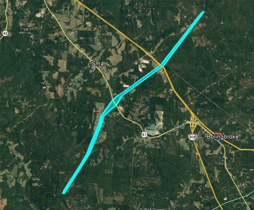
A weak tornado of EF-0 intensity initially touched down along Shi Road, downing many trees at this location. The tornado continued moving northeast and continued downing trees along its path. Fences were blown down along King Road. Along Boling Broke Road more trees were downed and a home experienced roof damage. The tornado continued downing and snapping a few trees as it crossed I-75 before lifting along Jenkins Road.
|
|
|
|
 |
| Many trees were snapped or uprooted near the tornadoes touchdown point along Shi Road. | This home on Boling Broke Road experienced roof damage. |
|
|
 |
| Reflectivity (12:11 PM EST). | Velocity (12:11 PM EST). |
|
(12:11 PM EST). |
12) Peach and Houston County Tornado:
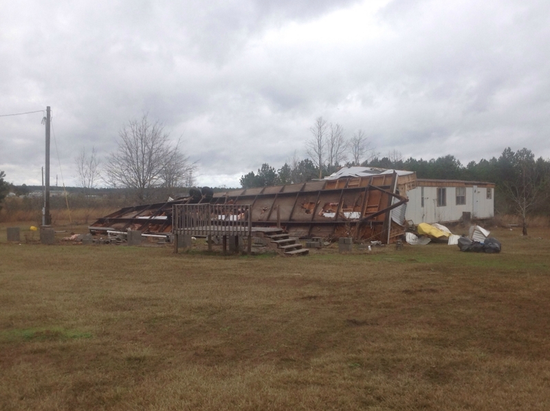
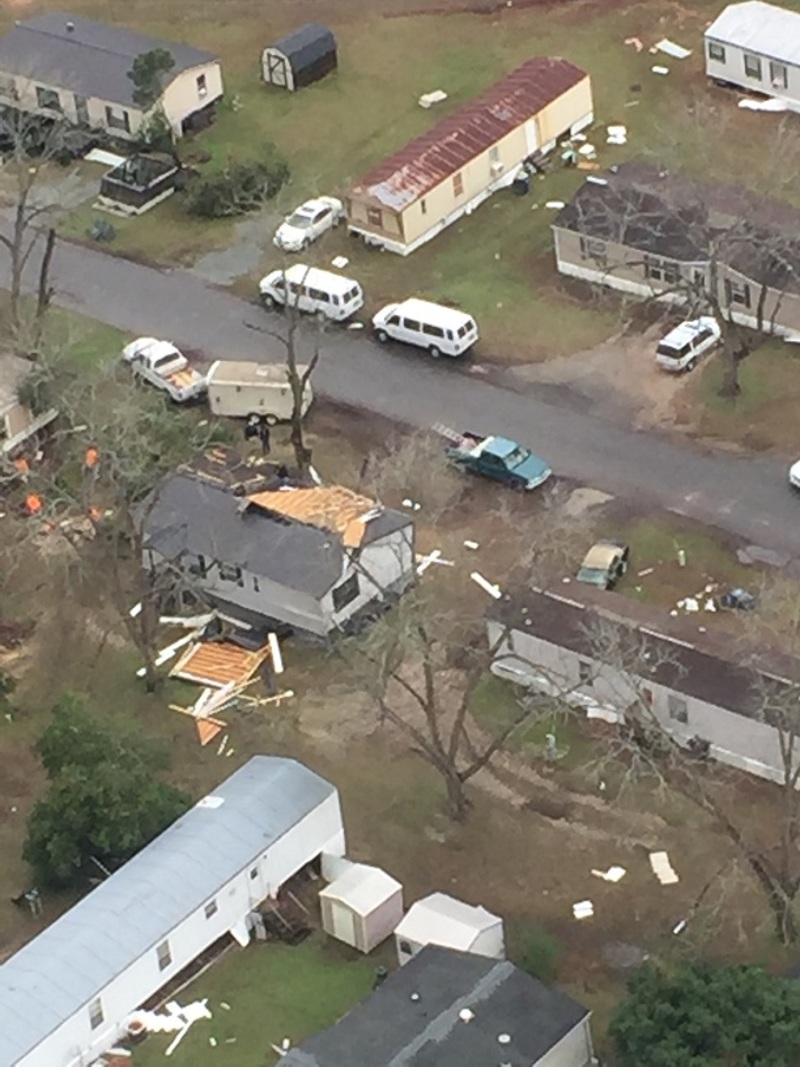
A long track tornado touched down along Andel Road, just N of the Peach/Houston County line. It tracked ENE, crossing I-75 in northern Houston County. The majority of the damage west of I-75 was trees either snapped or uprooted. There was minor damage to a couple homes in the form of shingles being blown off. The tornado continued NE, across I-75 uprooting and snapping trees including one that fell onto a nursing home along US-11. The tornado tracked ENE along Sandefur Rd doing a lot of damage to mainly trees. There were a few homes south of the road that sustained some roof damage along Griswold Way. There was some minor damage to a sports complex along Cohen Walker Road and a business northeast of the complex along with some tree damage. The storm crossed HWY 96 near Peach Blossom Road and continued NE through some neighborhoods west of Bonanza Drive causing minor roof and tree damage to some homes. The tornado crossed Feagin Mill Road near the intersection of Bonanza Drive where tree damage and minor roof damage was noted. The storm crossed Moody Drive and began intensifying as strong inflow winds were noted along Sandy Run Road and Echo Lane where brick fences were blown down and numerous trees were snapped or uprooted facing north into the intensifying storm. The worst of the damage occurred near the Walmart and adjacent neighborhood on Windmill Ct. 2 large HVAC units were thrown approximately 50 yards from the top of the Walmart. The auto bay doors on the back of the store were blown in and the roof was blown upward. The rafters on the other end of the store were twisted. Along Windmill Ct and Hidden Creek Circle 1 home had 80 percent of its roof removed and windows and doors blown in. Across the street, another home on Hidden Creek Circle had its garage door and front windows blown in and parts of the roof removed. The storm continued ENE into a mobile home park along Maxwell Drive and Sherry lane and caused damage to another 15-20 homes. One mobile home was nearly destroyed along Sherry Lane. The storm possibly continued onto Warner Robins, however, the NWS did not continue any further NE and will work with Warner Robins AFB to determine if it continued.
|
|
 |
 |
| The most significant damage EF-2 damage occurred to this home in a neighborhood off of Booth Rd in Warner Robins. The roof was removed and significant structural damage occurred. |
The garage door of this home was blown in, which allowed part of the roof to be removed. Also notice the board that was impaled into the front siding. |
 |
 |
| This mobile home off of Sherry Lane was destroyed by the tornado. |
The WalMart on Booth Road in Warner Robins sustained significant roof damage, which caused the store to be closed for repairs. |
|
|
 |
| Reflectivity (12:23 PM EST). | Velocity (12:23 PM EST). |
A tornado touched down in southern Twiggs County, near Bruce King Road west of Longstreet Road. It continued ENE mainly downing approximately 100 trees but also overturning one section of an irrigation system before lifting near BM Richardson Road.
|
|
|
|
 |
| Several trees were snapped or uprooted along Longstreet Road. | The tornado overturned part of this irrigation system. |
|
|
 |
| Reflectivity (12:47 PM EST). | Velocity (12:47 PM EST). |
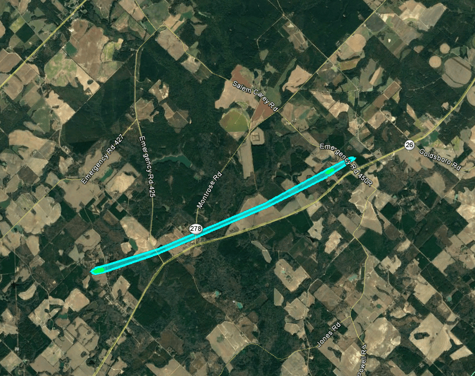
A tornado touched down just west of Churchwell Road east of Cochran, downing trees and a fence as well as lifting much of the roof off a small barn. The tornado traveled ENE, downing a few trees on Butts Road, then increased in strength as it caused minor roof damage to 3 homes and downed and snapped 20 to 30 large trees and power poles in a small subdivision on Emergency Road 445A off of Highway 26. The tornado weakened and damaged an abandoned fire station on Emergency Road 450R and Highway 26 before lifting.
|
|
|
|
 |
| A large number of trees were snapped or uprooted along Dogwood Acres Road. | This home on Dogwood Acres Road experienced roof damage |
|
|
 |
| Reflectivity (12:54 PM EST). | Velocity (12:54 PM EST). |
A tornado began south of Irwinton, east of US 441 Bypass where 3 to 4 trees were downed, one very near a house. The tornado then moved east along Highway 57 toward Toomsboro, downing several trees along the way. Little if any structure damage was observed.
|
|
|
|
 |
| This large tree was uprooted near Irwinton. | This massive tree was split in half in Toomsboro. |
|
|
 |
| Reflectivity (12:07 PM EST). | Velocity (12:08 PM EST). |
A brief weak EF-0 tornado touched down in southern Putnam County near the shore of Lake Sinclair. Damage primarily consisted of a number of trees snapped or uprooted along the short tornado path. The last evident damage consisted of several trees snapped and uprooted along the Norfolk Southern rail line. The tornado then lifted.
|
|
|
|
 |
| A large pine tree was snapped at this location. | Several trees were snapped or uprooted over the driveway of this home. |
|
|
 |
| Reflectivity (1:10 PM EST). | Velocity (1:11 PM EST). |
|
(1:10 PM EST). |
A brief weak tornado touched down just west of Buckeye Road and progressed East and then Northeast past Buckeye Road. Most all of the damage was due to uprooted trees with a couple dozen trees falling near the Buckeye Road area.
|
|
|
|
|
| Several trees were uprooted at this location on Buckeye Road. |
|
|
 |
| Reflectivity (1:21 PM EST). | Velocity (1:21 PM EST). |
A brief EF-1 tornado touched down on Deepstep Road straddling the Baldwin/Hancock County line. This tornado downed numerous trees as it moved along Deepstep Road. A home and accompanying building received minor siding and roof damage from the tornado. The tornado then lifted after moving roughly half of a mile.
|
|
|
|
 |
| The tornado removed part of the metal roof covering from this building. | Numerous trees were snapped or uprooted along Deepstep Rd on the Baldwin/Hancock County line. |
|
|
 |
| Reflectivity (1:29 PM EST). | Velocity (1:29 PM EST). |
|
(1:29 PM EST). |
19) Johnson County Tornado:
A tornado touched down in rural Johnson County, just south of Moores Chapel Road. It continued NE crossing HWY 57 and eventually lifted near the intersection of Harrison Road and Fortner Road. Damage consisted primarily of trees snapped or uprooted. One small farm outbuilding was destroyed, and a large outbuilding sustained roof damage.
|
|
 |
 |
| This large storage building sustained roof damage from the tornado. | This small outbuilding was destroyed. |
|
|
 |
| Reflectivity (1:40 PM EST). | Velocity (1:40 PM EST). |
|
(1:40 PM EST). |
Tornado damage extends approximately 15 miles in a non-continuous path. Damage is due to 3 separate tornadic circulations. This first tornadic segment started over an open field as an EF-0 but quickly intensified to a high-end EF-1 as it moved through a mobile home park. One mobile home facing perpendicular to the strongest winds was destroyed, while the remaining mobile homes remained largely untouched. The tornado continued as an EF-0, moving through mainly forested areas before briefly intensifying again and destroying another mobile home.
|
|
|
|
 |
| This unanchored mobile home was rolled and destroyed by the tornado. Surrounding mobile homes appeared largely untouched. | This mobile home was partially removed from its footings and sustained significant damage. |
|
|
 |
| Reflectivity (1:43 PM EST). | Velocity (1:43 PM EST). |
Tornado damage extends approximately 15 miles in a non-continuous path. Damage is due to 3 separate tornadic circulations. This second tornadic segment started over a sparsely populated residential area where it tore some shingles off roofs and destroyed a shed as an EF-0. The storm intensified to an EF-1 briefly as it approached a mobile home park where a mobile home was rolled, destroying it. The tornado turned north due to storm interactions but remained relatively weak for the remainder of the path and stayed over primarily forested areas.
|
|
|
|
 |
| This unanchored mobile home was flipped over and destroyed. | Several trees were uprooted near the tornado's endpoint. |
|
|
 |
| Reflectivity (1:46 PM EST). | Velocity (1:47 PM EST). |
Tornado damage extends approximately 15 miles in a non-continuous path. Damage is due to 3 separate tornadic circulations. This third tornadic segment remained an EF-0 for much of its lifespan until briefly strengthening over a pecan orchard where dozens of trees were uprooted.
|
|
|
|
 |
| Dozens of pecan trees were uprooted in this orchard. | This farm outbuilding was destroyed by the tornado. |
|
|
 |
| Reflectivity (1:55 PM EST). | Velocity (1:55 PM EST). |
|
|
|
|
 |
| This home on Noonday Church Road sustained minor roof damage. A covered front porch was also removed. | A number of trees were downed and snapped as the tornado crossed Womack Road. |
|
|
 |
| Reflectivity (2:12 PM EST). | Velocity (2:12 PM EST). |
January 22nd Tornadoes:
1) Dougherty/Worth/Turner/Wilcox Tornado:
Large long-track tornado touched down near Dougherty/Baker Co. line and travelled over 70 miles across Doughery, Worth, Turner, and Wilcox Counties in South Georgia. The tornado lifted just east of Abbeville. The tornado caused signficant damage along the track, resulting in 4 fatalities in Albany. Severe tree damage was observed along the entire path which was up to 1.2 miles wide. In many spots, 90 to 100 percent of the trees in the path were uprooted or snapped.
In Dougherty County, the tornado touched down on Tarva Road. By the time it reached Newton, the tornado was approximately 1.25 miles wide. There was extensive tree damage and some minor to moderate damage to a few homes in this area, consistent with EF2 damage. The tornado moved through the Radium Springs area, destroying nearly every tree in its path and causing EF2 damage to several houses. Most houses in this area had significant damage from falling trees. The tornado then moved through several mobile home parks just west of U.S. 319, destroying many mobile homes and causing the 4 fatalities. Damage consistent with and EF3 tornado was observed just east of U.S. 319. The tornado caused a large portion of a warehouse at the Proctor and Gamble Plant to collapse and tossed several semi-trailers across Mock Road. Additional EF3 damage was observed at the Marine Corp Logistics Base, where multiple anchored double-wide trailers were completely destroyed. In addition, several concrete light poles were snapped near the base, and a large solid concrete building had its solid concrete roof shifted more than 2 inches. A well-built concrete block church on Sylvester Rd was demolished with only parts of a few walls remaining. The estimated wind speed at this point is 150 mph, the highest analyzed along the track. EF3 damage was also observed on Harris Road where a cement block church was destroyed.
The tornado then entered Worth County and caused extensive damage to homes along Jewel Crowe Road. This was consistent with EF3 damage. Damage to homes and outbuildings consistent with EF2 damage was observed along Camp Osborn Road. A concrete block church on Zion Church Road was completely destroyed, justifying an EF3 rating at that point.
The tornado entered Turner County along and north of Son Story Road. Damage to a frame home along Ireland road was consistent with EF3 damage. Additional EF2 damage was found along this road. There was also some evidence for multiple vortices near the intersection of Ireland Road and U.S. 41. Additional EF3 damage was observed on King Burgess Circle where a large frame house was severely damaged and multiple mobile homes were destroyed. The tornado continued northeast across Interstate 75 causing EF2 damage to several frame homes and mobile homes. Tree damage diminished as the tornado approach the Wilcox county line, suggesting that the tornado temporarily weakened.
(At this point the tornado entered the NWS Atlanta County Warning Area):
The tornado continued its track into extreme southeast Crisp County and southwest Wilcox County. Damage was seen off Double Run Road (CR 42) and CR 41 where a small farm building was completely destroyed. Windows were broken at two residences and several small trees were uprooted. Just northeast, significant damage occurred along Crawford Dairy Road between July Road and Loblolly Road. A metal building structure was significantly damaged with the several anchored metal trusses completely pulled off the concrete foundation, resulting in a total collapse of the building. Additional farm outhouses/metal barns around the property were severely damaged, and hundreds of pines were flattened (snapped near their base) or uprooted. Farther along Crawford Dairy Road, just before SR 233, several large wooden electrical transmission towers were snapped (near the base) or leaning. The width of the tornado around this location is estimated to be at least one half mile. Along American Legion Road, between Bayberry Lane and Elderberry Lane, a large (semi-truck) trailer was flipped, flattened and moved across a road. One (southeast) corner of a metal building structure was completely destroyed with 2+foot (deep) concrete support beams ripped out of the ground. Numerous large trees were snapped near their bases around this location. A small home nearby sustained minor roof and siding damage. At this location, winds estimated to be 110-120 MPH, putting into an EF-2 category. Moving northeast along Willingham road, trees were snapped or uprooted. As the tornado went over Mount Olive Road, just south of Highway 280, several single, and double-wide manufactured homes were completely destroyed. Debris was moved 50-100 yards away from the original foundations. Based on this damage, the tornado may have briefly strengthened to around 135 MPH, but a large house just up the hill from this location only sustained minor roof damage. Additionally, trees around the manufactured home remained standing. These reasons increased the survey teams confidence to maintain the tornado at EF-2 strength in this area. The tornado crossed Highway 280 leveling numerous trees and destroying several small wooden sheds/barns. From this point, the tornado and parent supercell appeared to weaken considerably, with only some trees snapped or uprooted seen along Kingfisher Road, just west of Abbeville. No other damage was seen beyond Kingfisher and Harvey Road.
|
|
 |
 |
| This large barn building in Wilcox County was destroyed. | The tornado removed large steel beams from their concrete footings at this location in Wilcox County. |
 |
 |
| This mobile home in Wilcox County was completely destroyed by the winds of the EF-2 tornado. | This building in Wilcox County was largely destroyed. |
|
|
 |
| Reflectivity as supercell crossed into Wilcox County (4:09 PM EST). | Velocity as supercell crossed into Wilcox County (4:09 PM EST). |
A tornado touched down near Pateville Road before crossing the Georgia Florida Parkway was an EF-0. It remained a relatively weak tornado but did intensify to a max intensity of around 80 mph as it approached 30th Avenue West and entered into a residential area. Damage was incurred by both mobile home and single family units, with roof damage common to structures within the path. The tornado continued over eastern portions of Cordele before lifting after crossing Highway 257.
|
|
|
|
 |
| Several mobile homes sustained roof damage in Cordele. | This large warehouse building in Cordele experienced roof damage. |
|
|
|
| Reflectivity (x:XX PM EST). |
A tornado began just south of Antioch Road near US 21 where a few trees were uprooted. The tornado continued northeast where at least a dozen trees were uprooted or snapped at the 300 block of Antioch Road near where it intersects Lucas Road. The tornado weakened as it traveled northeast before lifting just southeast of the intersection of Tom Porter Road and Daisy Adams Road.
|
|
|
|
 |
| Numerous trees alongside this pond were snapped or uprooted by the tornado. | The tornado downed a number of trees on this property. |
|
|
 |
| Reflectivity (4:17 PM EST). | Velocity (4:18 PM EST). |
A brief tornado began near Dillard-Cary Road northwest of the Cary community where it uprooted a few trees. The tornado traveled just over one-half mile before lifting. Six to eight trees were uprooted near the 320 block of Willis-Howell Road.
|
|
|
|
 |
| A number of trees were snapped and downed near the tornado's touchdown point on Dillard-Cary Road. | Several large trees were downed at this home on Willis Howell near the tornado's end point. |
|
|
 |
| Reflectivity (4:22 PM EST). | Velocity (4:23 PM EST). |


.png)