October 6, 2014 Severe Weather Event
An active pattern continued across Georgia on Monday, October 6, 2014 as the long wave trough persisted across the eastern half of the United States. Multiple disturbances caused a few rounds of showers and thunderstorms over the course of Monday and Tuesday across far north Georgia. Although a few areas observed small hail Monday throughout the day, the severe weather was confined to Monday evening. Multiple reports of hail were received across far northwest Georgia with some of the hail reaching golf-ball sized. In addition to the hail reports that were received, one tornado touched down in Catoosa County that resulted in damage to a few houses.
 |
|
| 500-mb pattern on October 6, 2014 | Local Storm Reports from October 6, 2014 |
Catoosa County:
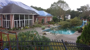
An EF-1 tornado touched down just north of Ringgold at approximately 7:40PM EDT on October 6, 2014. The tornado was on the ground less than half a mile and for less than a minute but dozens of trees were snapped or uprooted in the Calloway Farms Subdivision. At least two homes sustained damage with several windows blown out and damage to shingles and gutters. One home lost a section of its roof and attic wall and on another home, the garage doors were blown out.
 |
|
| Damage to the attic of a house | Downed trees and debris from tornado |