Summary of Flooding and Tornado Event of April 6th and 7th, 2014
Event Summary
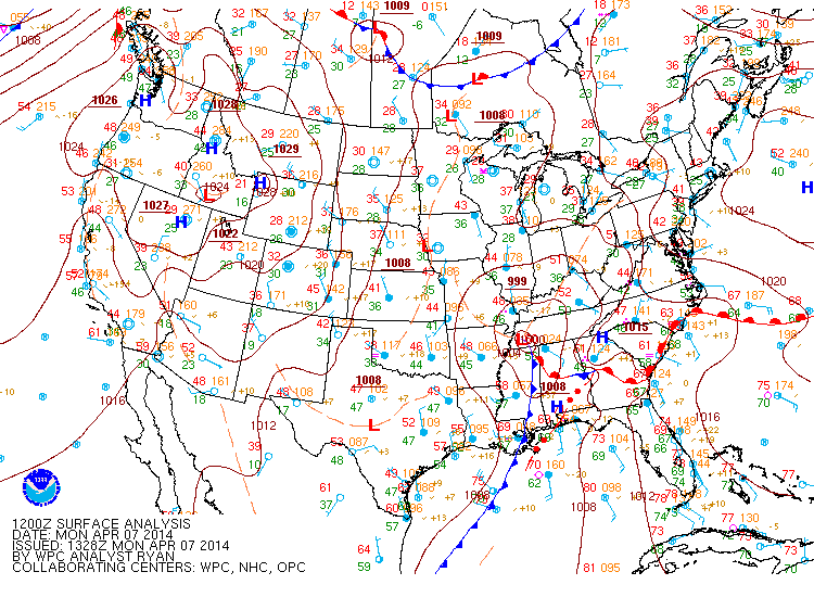
On Sunday and Monday, April 6-7, 2014, a strong storm system impacted north and central Georgia. A strong “wedge” moved into northeast Georgia from the Carolinas early on Sunday the 6th, bringing cool and stable conditions to the area. Moisture from the Gulf began overspreading the Southeast during the day, with a developing area of widespread rain. Meanwhile, a strong upper level system moved out of the Plains, dragging a cold front across the Southeast on Monday the 7th. Moisture continued to stream across the area ahead of the cold front, with widespread rain continuing overnight Sunday night and into the morning hours on Monday. A significant amount of deep-layer shear (turning of the winds with height) was in place, and though instability was minimal, there was enough to create an environment supportive of isolated severe thunderstorms, prompting the Storm Prediction Center to issue a Tornado Watch for central and portions of north Georgia through Monday afternoon for the area of showers and thunderstorms ahead of the cold front. The cold front itself moved into Georgia during the late afternoon hours of Monday, with showers and isolated thunderstorms redeveloping through the evening as the front pushed through.
 |
 |
 |
| Surface Analysis April 6th | Surface Analysis April 7th | Surface Analysis April 8th |
 |
 |
 |
| 500mb Analysis April 6th | 500mb Analysis April 7th | 500mb Analysis April 8th |
One of the main impacts from this storm system resulted from the extensive rainfall amounts. Over about a 48 hour period, widespread 2-4 inches of rain fell across north Georgia and parts of west central Georgia. Isolated areas even received more than 4 inches of rain – Columbus reported 4.42 inches from Sunday through Monday, the majority of this falling in a 6-hour period late Sunday night into early Monday morning. These higher rainfall amounts, especially the larger amounts that fell in a short time period early Monday morning, caused many rivers to reach flood stage. As of Tuesday afternoon (April 8, 2014), 38 river flood warnings and 2 flash flood warnings were issued for areas across north and central Georgia and many points still remain in flood.
|
|
 |
| Rivers Still In Flood(Orange) Or Close To Flood(Yellow) As of Tuesday Evening | 48 Hour Rainfall Totals |
|
|
 |
| Floyd County Flooding (Image Courtesy of WSB) | Woodward Way and Peachtree Battle Flooding (Image courtesy of CBS 46) |
In addition to the widespread flooding across north and central Georgia, an EF-1 tornado with 95 mph winds was confirmed in Spalding County in one of the thunderstorms that developed along the front late Monday evening. Around 200 trees were downed by the tornado and at least a dozen homes sustained minor roof damage. The most significant damage was a tree that fell onto a home along Highway 92. Several outbuildings sustained minor to moderate damage. Three injuries occurred with this event when cars were either struck or ran into downed trees along Highway 92 near Bicycle Road.
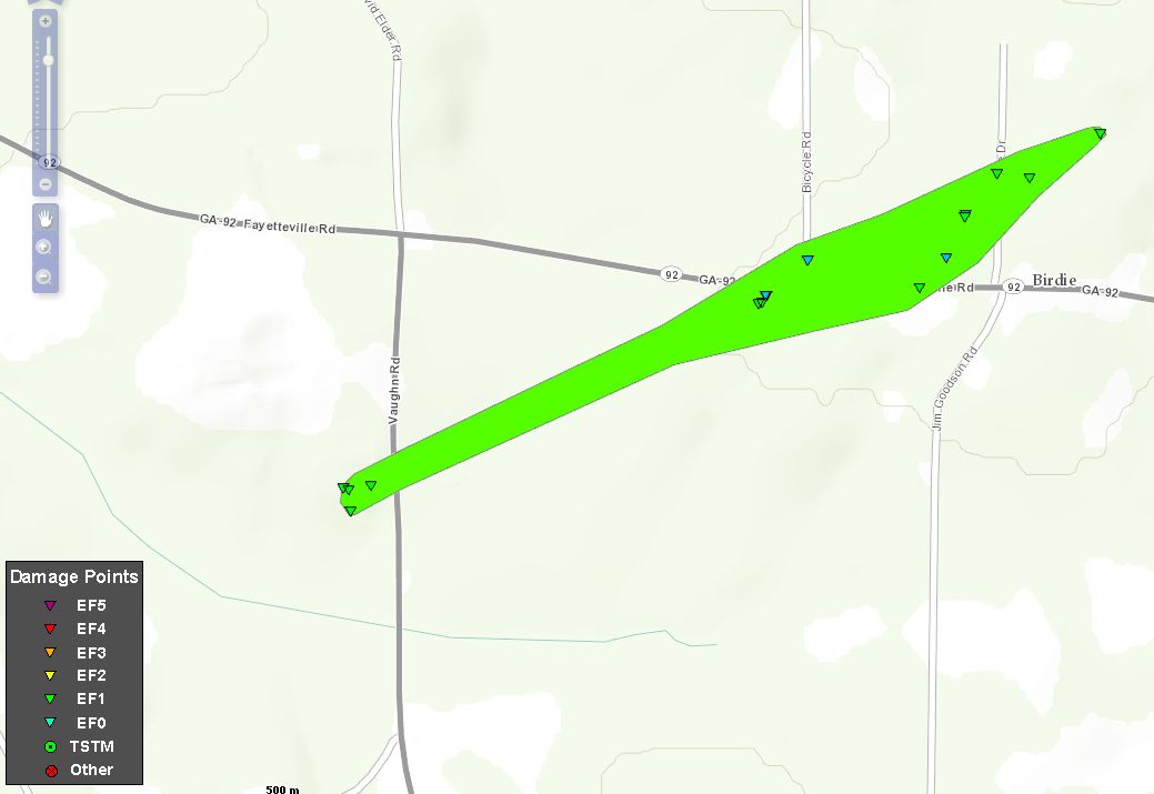
Damage Path
County
Rating
# of Injuries
KML
Spalding
EF-1
3

Rating:
Peak Wind:
Path Length:
Path Width:
Fatalities:
Injuries:
Start Date:
Start Time:
Start Location:
Start Lat/Lon:
End Date:
End Time:
End Location:
End Lat/Lon:EF-1
95 MPH
0.94 MILES
150 YARDS
0
3
APRIL 7 2014
9:50 PM EDT
8 MILES NW OF GRIFFIN
33.3025/-84.3850
APRIL 7 2014
9:52 PM EDT
4 MILES SSE OF WOOLSEY
33.3086/-84.3705
 |
 |
| Spalding Tornado Damage | Spalding Tornado Damage |
 |
| Spalding Tornado Damage |


