|
Severe Weather Strikes
North and West Georgia
April 11, 2013
|
The combination of a strong upper level system, moist southeasterly flow and a cold front resulted in severe weather across much of north and central Georgia during the late afternoon and overnight hours of April 11 and 12, 2013. Severe weather reports included numerous trees downed, up to baseball sized hail and two tornadoes.

Early Thursday morning a cold front was crossing into the Lower Mississippi River Valley and a squall line had develped ahead of the front across eastern Mississippi. The squall line was long lived and tracked into Georgia during the late evening and overnight hours. During the late afternoon and early evening, a strong piece of shortwave energy moved into the southeast states and rounded the base of a longwave mid-level trough. This feature served to initiate and sustain thunderstorms that developed out ahead of the squall line across eastern Alabama and western Georgia by steepening mid-level lapse rates and increasing lift.
It was the discrete supercell thunderstorms that developed out ahead of the squall line that produced the bulk of the severe weather. The first Severe Thunderstorm and Tornado Warnings across southern Haralson and northern Carroll counties were issued just after 615 PM. The radar images below show the more significant supercell over Haralson county at 630 PM as a tornado produced minor damage southeast of Tallapoosa.

These storm cells tracked northeast into the Metro Atlanta area between 730 PM and 8 PM, prompting a Severe Thunderstorm Warning for the northern suburbs of Atlanta around 815 PM and another around 900 PM.
An EF-1 tornado tracked across southeastern Lumpkin and far northwestern Hall counties around 930 PM damaging 17 homes. The radar images below show the strong storm bowing out on the left side of the image and very strong 85-95 MPH winds about 7,000 ft above the ground on the right, associated with the tornado.

The squall line finally moved across northern and portions of central Georgia during late Thursday evening and early Friday morning, prompting additional Severe Thunderstorm Warnings.
Haralson County Tornado
Rating: EF-0
Max wind speed: 85 MPH
Path length: 5.75 miles
Path width: 150 yards
Injuries: 0
Deaths: 0
Start time: 6:23 PM EDT (April 11, 2013)
End time: 6:31 PM EDT (April 11, 2013)
Begin point: 33.675N / 85.305W (5 miles south-southwest of Tallapoosa)
End point: 33.735N / 85.237W (3 miles east-southeast of Tallapoosa)
This tornado touched down just south of I-20 near Chandler Rd and continued northeast crossing Kings Gin Rd and along Thomas Rd snapping and uprooting several dozen trees. Three homes on Kings Gin Rd sustained minor roof damage where shingles or a portion of the roof was peeled back. The tornado crossed I-20 knocking over several trees on both the east and west bound side, just east of where Old Georgia 100 crosses I-20. The tornado continued across Dr King Rd and Petty Rd snapping and uprooting trees and just missing a large manufacturing center. The tornado continued northeast and began to weaken as it headed northeast across State Hwy 100, Daniel road and U.S. Hwy 78. Several trees were uprooted and snapped along that path and a flower shop sustained minor roof damage at the intersection of U.S. Hwy 78 and Old Ridgeway Rd. The tornado lifted shortly after crossing Hwy 78. Other tree damage related to this storm was found near the intersection of Old Georgia 100 and Payne Milling Rd as well as on the Tally Mountain Golf course. This damage was determined to be caused by straight line winds as it did not line up with the primary path of the tornado and doppler radar indicated mesocyclone.

Several large trees downed south of I-20 in Haralson county
Lumpkin-Hall County Tornado
Rating: EF-1
Max wind speed: 105 MPH
Path length: 4.1 miles
Path width: 250 yards
Injuries: 0
Deaths: 0
Start time: 9:23 PM EDT (April 11, 2013)
End time: 9:29 PM EDT (April 11, 2013)
Begin point: 34.4515N / 83.9300W (6.3 miles southeast of Dahlonega)
End point: 34.4879N / 83.8744W (2.5 miles southeast of Garland)
Damage started in Lumpkin county along Gold Ridge Road where numerous trees were snapped or uprooted. One small outbuilding had its roof blown off and two homes sustained minor roof damage. The tornado tracked northeast crossing Evergreen Court where trees were snapped and uprooted. The tornado reached maximum intensity shortly after and along Bridgestone Way where it paralleled the road. Numerous hardwood and softwood trees were snapped and uprooted. Some of the trees fell onto homes. Twelve homes were damaged on Bridgestone Way with two of them destroyed by trees. The tornado tracked northeast into Hall county where it crossed Old Whelchel Road snapping a few trees and downing powerlines. Two homes sustained very minor roof damage. The tornado continued northeast crossing back into Lumpkin county crossing Old Dahlonega Highway, damaging a few trees. Two mobile homes were damaged by falling trees along Mount Olive Church Road and several powerlines were downed. The tornado eventually weakened and lifted just before crossing Claude Perks Road and Starwood Drive. In all, 41 homes were affected, two of which were destroyed, three of which sustained major damage and three of which sustained minor damage.
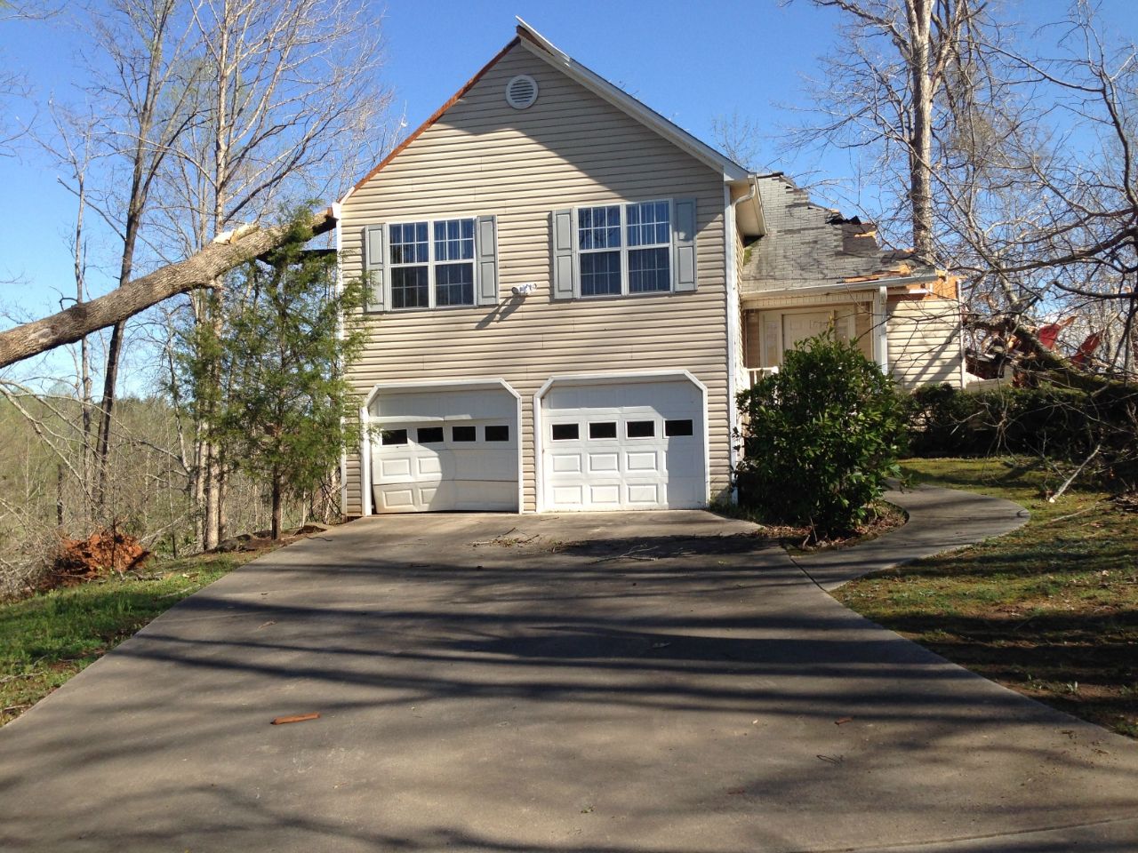
Home near the Lumpkin-Hall county line suffered major damage after a large oak tree fell on it. Note the garage door which almost failed due to the strong wind.
Polk County Tornado
Rating: EF-1
Max wind speed: 85-105 MPH
Path length: 0.3 miles
Path width: 25 yards
Injuries: 0
Deaths: 0
Start time: 7:01 PM EDT (April 11, 2013)
End time: 7:02 PM EDT (April 11, 2013)
Begin point: 33.988N / 84.995W (2 miles west of Braswell)
End point: 33.993N / 84.993W (2 miles west of Braswell)
This was the second tornado associated with a supercell thunderstorm that moved from Haralson County to Polk County and into Paulding County. The tornado touched down near railroad tracks just south of Coots Lake Road where some trees were uprooted. From this point the tornado traveled to the north northeast due to an occluding mesocyclone. The most damage occurred in a wooded area three tenths of a mile north of where the tornado touched down north of Braswell Road. At this point approximately 50 trees were snapped and about 25 trees were uprooted. The tornado dissipated in an open area just short of a residence. Damage was confined to trees.

Numerous trees snapped from the Polk County tornado.
|

