Tropical Storm Lee Tornado and Flooding in Georgia
The remnants of Tropical Storm Lee moved slowly across the Southeastern U.S. Monday, September 5th and a cold front moved toward the state from the northwest. These two features combined forces to bring heavy rain, flooding and several possible tornadoes to north and central Georgia.
The most extensive storm damage was reported in Cherokee County, in Woodstock and Canton, where law enforcement officials reported a tornado Monday afternoon. On Tuesday, a National Weather Service team conducted a survey of the Cherokee County tornado and more specifics are below. No other tornadoes were confirmed across the Peachtree City forecast area on Monday.
Tornado Details
![[ Path of EF-1 tornado that struck Cherokee County. ]](/images/ffc/events/110905_lee/cherokee_track.png) Path of EF-1 tornado that struck Cherokee County. |
![[ Tornado Damage from Holly Springs. ]](/images/ffc/events/110905_lee/HollySprings2.jpg) Damage to a house in Holly Springs, GA (Cherokee County). |
![[ Tornado Damage from Cherokee County. ]](/images/ffc/events/110905_lee/Cherokee.jpg) Damage from the EF-1 tornado in Cherokee County. |
![[ Tornado Damage from Cherokee County. ]](/images/ffc/events/110905_lee/HollySprings.jpg) Trees snapped by the EF-1 tornado in Holly Springs, GA (Cherokee County). |
![[ Reflectivity image of CherokeeTornado. ]](/images/ffc/events/110905_lee/cherokee_kffc_z_1910.png) Reflectivity image of Cherokee County tornado. |
![[ Storm Relative Velocity of Cherokee tornado. ]](/images/ffc/events/110905_lee/cherokee_kffc_srm_1910.png) |
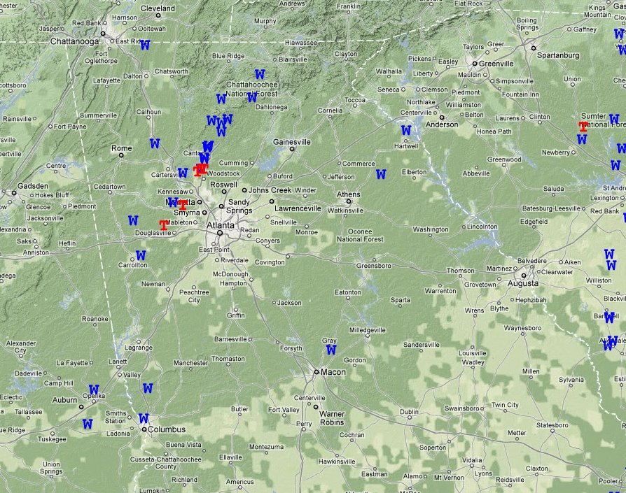
The tornado that affected Cherokee county was not the only severe weather observed locally September 5th. We also had numerous wind damage reports in the stronger cells that pushed through the area which can be seen on the map below. Some of the wind reports to the north were actually the result of strong winds outside of thunderstorm activity that were able to take down trees given the moist ground from abundant rainfall. For a more interactive map with additional details, please click on the link atop the image.
Interactive Local Storm Report Viewer
Rainfall amounts of 7 to 10 inches occurred over the northwest corner of Georgia on Monday. The heaviest rain was generally in Dade, Walker, Catoosa, Whitfield and Chatooga Counties. Several flash flood warnings and river flood warnings were issued Monday afternoon and evening due to widespread flooding. Significant flooding caused 33 people to be evacuated from an apartment complex in Fort Oglethorpe, Georgia on Monday afternoon. Also a family was rescued near Trenton, Georgia as flood waters surrounded their home. The flood waters receded on Tuesday and Wednesday. Below is a rainfall estimate map showing totals for the entire period that the remnants of Lee affected the local area. For a more interactive map with additional details, please click on the link atop the image.


