Fast Facts
|
|
Maximum Wind Gusts

Public Information Statement
National Weather Service Quad Cities IA IL
837 PM CST Wed Dec 4 2024

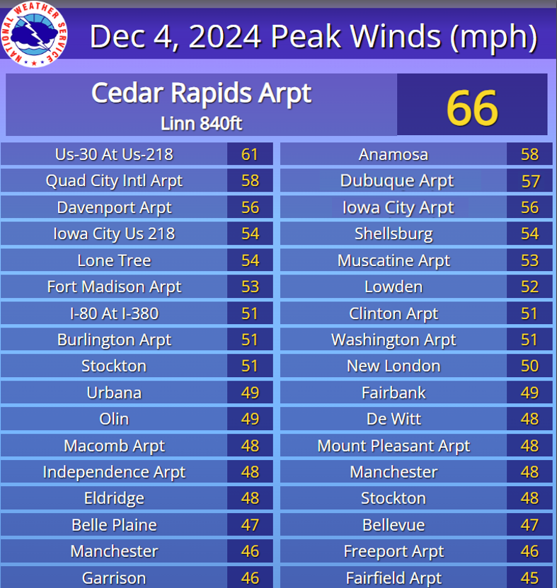
...HIGHEST WIND REPORTS TODAY THROUGH 830 PM...

Location                     Speed     Time/Date       Provider
---------------------------------------------------------------
Cedar Rapids Arpt            66 MPH    0604 PM 12/04   ASOS
1 NNE Aurora                 63 MPH    0545 PM 12/04   AWS
Us-30 At Us-218              61 MPH    0555 PM 12/04   MESOWEST
Quad City Intl Arpt          58 MPH    0648 PM 12/04   ASOS
Anamosa                      58 MPH    0525 PM 12/04   MESOWEST
Dubuque                      56 MPH    0306 PM 12/04   CWOP
Dubuque Arpt                 56 MPH    0142 PM 12/04   ASOS
Davenport Arpt               56 MPH    0543 PM 12/04   ASOS
Iowa City Arpt               56 MPH    0726 PM 12/04   ASOS
Quad Cities                  55 MPH    0755 PM 12/04   MESOWEST
Lone Tree (WEATHERSTEM)      54 MPH    0700 PM 12/04   MESOWEST
SHELLSBURG                   54 MPH    0504 PM 12/04   CWOP
Iowa City Us 218             54 MPH    0635 PM 12/04   MESOWEST
Muscatine Arpt               53 MPH    0715 PM 12/04   AWOS
0.6 W Lowden (UPR)           53 MPH    0520 PM 12/04   MESOWEST
Stockton                     51 MPH    0415 PM 12/04   CWOP
MACOMB                       51 MPH    0736 PM 12/04   CWOP
Burlington Arpt              51 MPH    0627 PM 12/04   ASOS
Clinton Arpt                 51 MPH    0716 PM 12/04   AWOS
I-80 At I-380                51 MPH    0345 PM 12/04   MESOWEST
New London                   50 MPH    0700 PM 12/04   CWOP
Independence                 50 MPH    0130 PM 12/04   CWOP
Olin                         49 MPH    0705 PM 12/04   CWOP
Fairbank                     49 MPH    0600 PM 12/04   CWOP
Washington Arpt              49 MPH    0815 PM 12/04   AWOS
Davenport                    49 MPH    0735 PM 12/04   MESOWEST
Urbana                       49 MPH    0440 PM 12/04   MESOWEST
28thaw                       49 MPH    0602 PM 12/04   MESOWEST
Stockton                     48 MPH    0445 PM 12/04   DAVIS
Eldridge                     48 MPH    0635 PM 12/04   CWOP
MANCHESTER                   48 MPH    0515 PM 12/04   CWOP
Independence Arpt            48 MPH    0635 PM 12/04   AWOS
Macomb Arpt                  48 MPH    0615 PM 12/04   AWOS
De Witt                      48 MPH    0735 PM 12/04   MESOWEST
Bellevue                     47 MPH    0335 PM 12/04   DAVIS
Mount Pleasant Arpt          47 MPH    0455 PM 12/04   AWOS
0.7 W Belle Plaine (UPR)     47 MPH    0313 PM 12/04   MESOWEST
Fairfax                      46 MPH    0755 PM 12/04   DAVIS
Garrison                     46 MPH    0555 PM 12/04   DAVIS
Freeport Arpt                46 MPH    0415 PM 12/04   AWOS
Manchester                   46 MPH    0345 PM 12/04   MESOWEST
Us-30 Mt Vernon              46 MPH    0535 PM 12/04   MESOWEST

Observations are collected from a variety of sources with varying
equipment and exposures. We thank all volunteer weather observers
for their dedication. Not all data listed are considered official.
Meteorology
|
|
|
 |
|
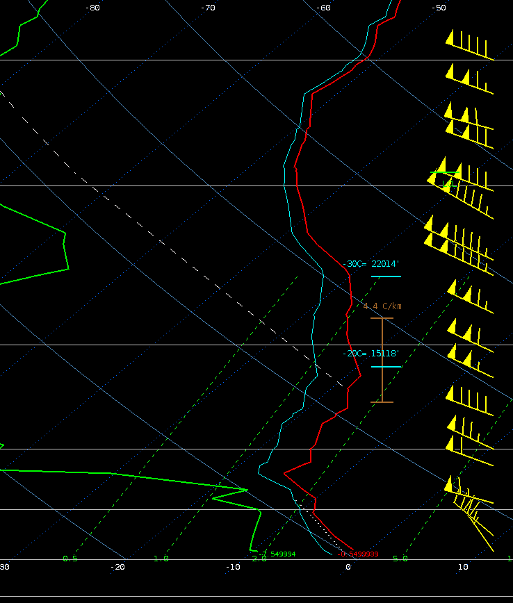
| December 4, 2024 Satellite Water Vapor Imagery: A robust upper level disturbance showed up clearly in the water vapor. Such a robust dry presence often correlates to a stratospheric intrusion, which means a deepening weather systems and more influences on weather down to the surface (in this case wind and strong cold air advection). | December 4, 2024 6 P.M. Surface Weather Map: A strong pressure gradient (packing of isobar lines) was present between a deep low pressure of ~991 mb and a modified arctic high pressure of 1038 mb. This helped drive the higher wind speeds, while the circulation around the low pressure oriented the wind direction from the north steering in much colder air. | December 4, 2024 5 P.M. Weather Balloon Data: This observed vertical profile plot shows temperature (red), dew point (green), and wind vectors (yellow). The very strong unidirectional wind field was a favorable setup for gusts to be maximized. The cold air moving in at a faster rate just off the surface steepened the low-level lapse rates aiding in vertical mixing and momentum transfer of strong winds down to the surface. |
|
|
 |
|
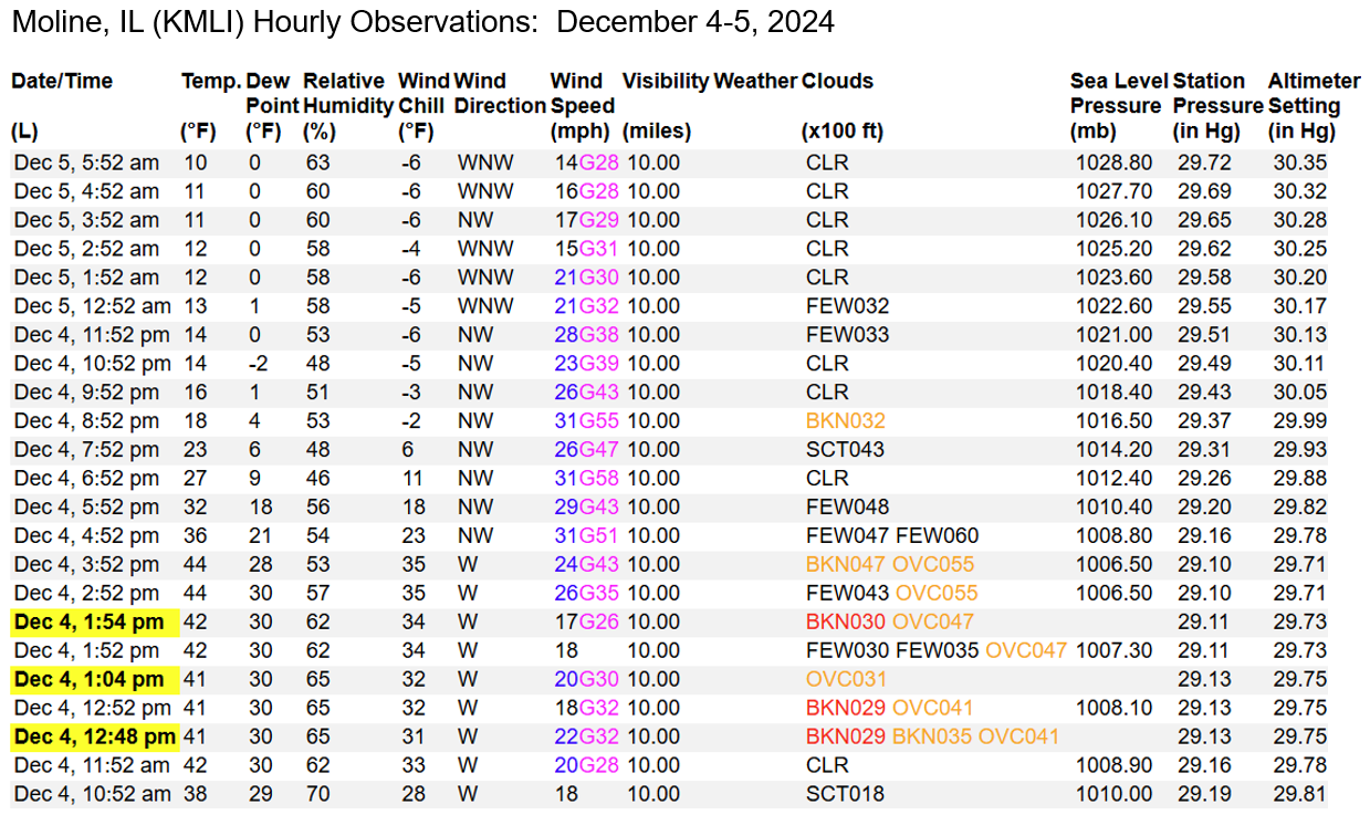
| December 4-5, 2024 6 P.M. Cedar Rapids, IA Hourly Observations | December 4-5, 2024 6 P.M. Moline, IL Hourly Observations |
 |
Media use of NWS Web News Stories is encouraged! |
 |