Event Overview: December 1st, 2018
|
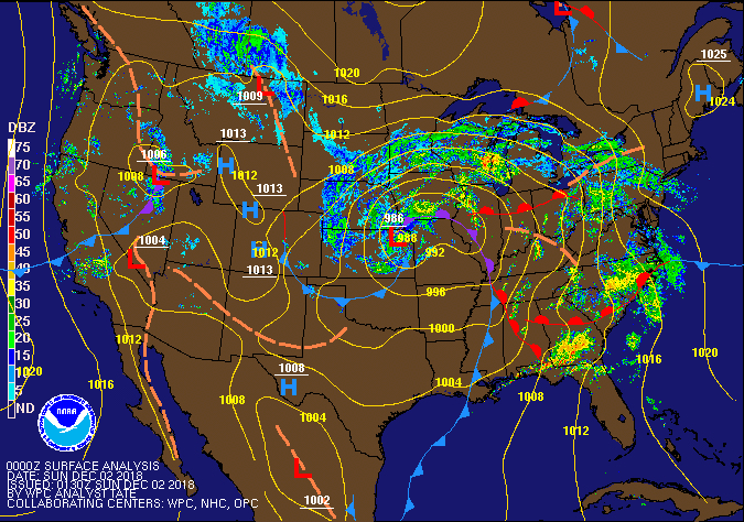
A storm system trudged eastward across northern Missouri Saturday, bringing widespread rain to eastern Iowa, northwest Illinois, and northeast Missouri on Saturday morning. Scattered showers and thunderstorms also developed on Saturday afternoon across west central Illinois along a warm front that lifted into Hancock, McDonough, and Warren Counties. Two brief tornadoes occured in McDonough County along with hail up to the size of pennies.
Surrounding Office Event Summaries
|
|
Tornado Information
|
Tornado #1 - 3 NW Industry, IL
Track Map
|
||||||||||||||||
|
Tornado #2 - 2 SW Bardolph, IL
Track Map

|
||||||||||||||||
The Enhanced Fujita (EF) Scale classifies tornadoes into the following categories:
| EF0 Weak 65-85 mph |
EF1 Moderate 86-110 mph |
EF2 Significant 111-135 mph |
EF3 Severe 136-165 mph |
EF4 Extreme 166-200 mph |
EF5 Catastrophic 200+ mph |
 |
|||||
Storm Reports
| SPC Storm Reports |
 |
PRELIMINARY LOCAL STORM REPORT...SUMMARY
NATIONAL WEATHER SERVICE QUAD CITIES IA IL
809 PM CST SAT DEC 1 2018

..TIME...   ...EVENT...      ...CITY LOCATION...     ...LAT.LON...
..DATE...   ....MAG....      ..COUNTY LOCATION..ST.. ...SOURCE....
            ..REMARKS..

0759 PM     HEAVY RAIN       1 WNW MORRISON          41.81N 89.98W
12/01/2018  M1.15 INCH       WHITESIDE          IL   TRAINED SPOTTER

            DAILY TOTAL.

0457 PM     HAIL             1 NNW MOUNT CARROLL     42.10N 89.98W
12/01/2018  E0.25 INCH       CARROLL            IL   TRAINED SPOTTER


0342 PM     TORNADO          2 SW BARDOLPH           40.48N 90.59W
12/01/2018                   MCDONOUGH          IL   TRAINED SPOTTER

            MEDIA RELAYED A SPOTTER REPORT OF A BRIEF
            TORNADO TOUCH DOWN. TIME AND LOCATION OF THE
            EVENT WAS ESTIMATED USING RADAR.

0318 PM     TORNADO          3 NW INDUSTRY           40.36N 90.65W
12/01/2018                   MCDONOUGH          IL   PUBLIC

            BRIEF TOUCH DOWN BARELY MISSING A HOUSE.
            TORNADO WAS ON THE GROUND FOR APPROXIMATELY
            10 TO 15 SECONDS.


&&

$$
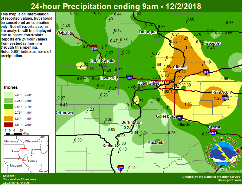
Area Rainfall Amounts
|
24-hr Local Rainfall Map
|
24-hr Regional Rainfall Map
|
24 hour precipitation reports (in Inches),
for eastern Iowa, northwest and west central Illinois,
and northeast Missouri. Reported between Midnight and 9 AM,
Sunday December 02, 2018.

....IOWA....
Le Claire 1.8 NNE                1.36
Camanche 1.2 W                   1.25
NWS Johnston* 5 NNW              1.09
Ames US 30 2 SSE                 1.06
Bettendorf 2.2 SE                1.03
Perry 0 W                        1.01
De Witt                          1.00
Bettendorf 1.6 WSW               0.98
Boone 1 SSW                      0.96
Hampton 1 N                      0.86
Bellevue LD12                    0.85
Charlotte 1.9 WNW                0.85
Cedar Rapids 2.7 NE              0.84
Marengo 3.6 N                    0.82
Marshalltown 1 NW                0.82
Davenport 0.9 SSW                0.81
Amana 4.7 W                      0.78
Davenport 0.9 WNW                0.77
Iowa City Arpt                   0.77
Fayette 1 NW                     0.75
Davenport Arpt 5 N               0.73
Maquoketa 4 W                    0.73
Eldridge 0.7 SSW                 0.73
Fairfax 4.0 NW                   0.68
Center Point 0.6 NNW             0.68
Calamus 2.0 NE                   0.68
Muscatine 2N                     0.67
Marion 1.7 NNW                   0.67
Central City 6.7 W               0.64
Anamosa 3 SSW                    0.63
Vinton                           0.63
Toledo 3 N                       0.61
Beaconsfield 1 NNE               0.60
Muscatine 2.1 N                  0.59
Mason City ASOS 6 W              0.59
Kalona 7.3 NNW                   0.59
Cedar Rapids Arpt 5 SW           0.58
Pella 4 N                        0.58
Dubuque Arpt 7 SW                0.57
Dubuque LD11                     0.55
Wellman 4.0 E                    0.53
Parnell 0.1 SSW                  0.53
Rickardsville 0.2 W              0.52
Allerton 2 S                     0.52
Guttenberg Dam 10                0.52
Solon 0.3 ESE                    0.52
Iowa City 8.0 NE                 0.50
Marshalltown ASOS 4 N            0.50
North Liberty 0.7 SSW            0.49
Waterloo ASOS 5 NW               0.48
Ainsworth 7.4 N                  0.47
Coggon                           0.47
Pella AWOS 2 WSW                 0.46
Manchester                       0.45
Tripoli 0 N                      0.45
Grinnell AWOS 2 SSW              0.45
Elkader 6SSW                     0.44
Mount Auburn 2.2 NNW             0.44
Ottumwa ASOS 6 NNW               0.42
Strawberry Point                 0.40
Williamsburg                     0.40
Hopkinton 5.4 WSW                0.36
Salem 1S                         0.35
Cedar Rapids 3.4 NW              0.30
Oskaloosa AWOS 9 ESE             0.27
Burlington Arpt 2 SW             0.27
Washington                       0.26
Fairfield                        0.23
Mason City 1 NNE                 0.15
Morning Sun 1.7 E                0.12
Donnellson                       0.09
Keokuk LD19                      0.03
Burlington 2.1 S                 0.00
....ILLINOIS....
Coal Valley 1.9 SE               1.70
Elizabeth                        1.42
Savanna 4.6 N                    1.25
Tiskilwa 2.1 N                   1.20
Coleta 1.4 SSW                   1.18
Mundelein                        1.13
Altona                           1.06
Princeton 1.1 SE                 1.05
Princeton                        1.05
Quad City Arpt 3 S               1.02
Coal Valley 2.6 E                1.02
Galena                           0.91
New Boston LD17                  0.91
Walnut 5.3 ENE                   0.90
Romeoville                       0.89
Lincoln NWS                      0.89
Paw Paw 1 E                      0.84
Joliet                           0.81
Galesburg                        0.80
Freeport                         0.79
Freeport 2.0 NW                  0.79
Stockton 3.4 NNE                 0.78
Freeport 1.7 NW                  0.77
Freeport 2.9 WSW                 0.74
Pearl City 0.4 SW                0.74
Rockford ASOS                    0.73
Ill. City LD16 3 WNW             0.72
Geneseo 2.0 NW                   0.68
Davis 0.5 N                      0.66
Macomb                           0.65
Winslow 4.3 ESE                  0.64
Peoria ASOS                      0.63
Bloomington Airport              0.61
Roscoe 2SE                       0.61
Steward                          0.56
Minonk                           0.56
La Harpe                         0.54
Ottawa 4 SW                      0.46
Shannon 0.2 S                    0.46
Ogden                            0.43
Aledo                            0.38
Alexis 1 SW                      0.31
Decatur Airport                  0.28
Prairie City 2S                  0.26
St Anne                          0.25
Dakota 4.8 NW                    0.20
Colchester 3.5 NE                0.16
Dallas City 3.0 SSE              0.14
Warsaw 5.8 SE                    0.13
Tuscola                          0.12
Quincy ASOS                      0.11
Quincy Dam 21                    0.10
Windsor                          0.09
Nauvoo 0.7 SSE                   0.03
Jacksonville AWOS                0.00
Rochelle AWOS                    0.00
Galesburg Arpt 3 SW              0.00
....MISSOURI....
Chillicothe 2 NW                 0.25
Kirksville ASOS                  0.14
Columbia                         0.01
Memphis                          0.00
....WISCONSIN....
Viroqua                          0.87
La Crosse WFO                    0.77
Beloit-College                   0.76
Allenton-WWTP .6 NW              0.75
Brodhead 1 SW                    0.63
Madison-ASOS                     0.61
Darlington                       0.60
Prairie du Chien AWOS            0.45
Whitewater                       0.45
Watertown-AWOS                   0.26
....MINNESOTA....
Grand Meadow                     0.33
Environmental Analysis / Other Information
SPC Convective Outlooks
 |
 |
 |
 |
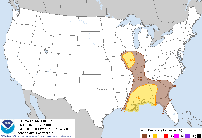
| SPC Day 1 Outlook (2000z) | SPC Day 1 Tornado Outlook (2000z) | SPC Day 1 Wind Outlook (2000z) | SPC Day 1 Hail Outlook (2000z) |
Sounding Analysis
 |
 |
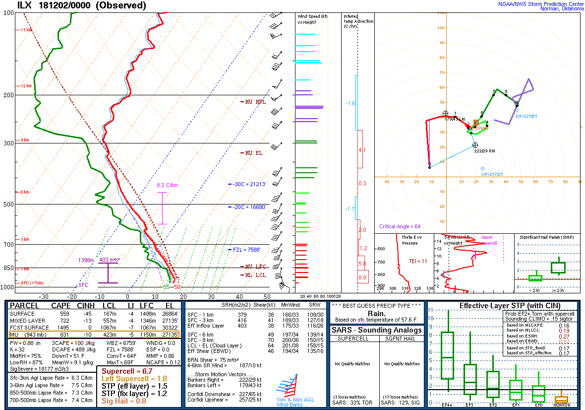 |
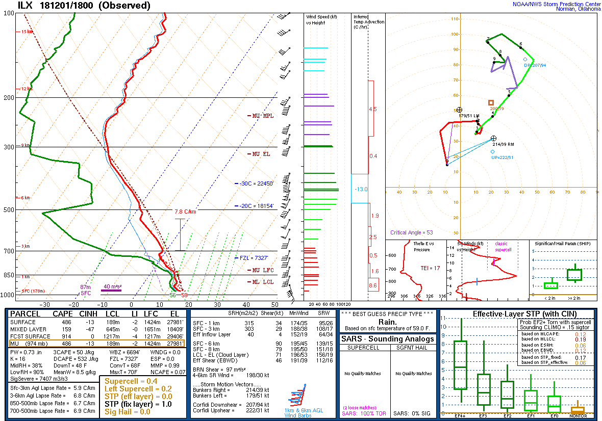
| DVN Sounding 12/2/18 00z | ILX Sounding 12/1/18 18z | ILX Sounding 12/2/18 00z |
SPC Mesoscale Discussions Issued for Our Area
 |
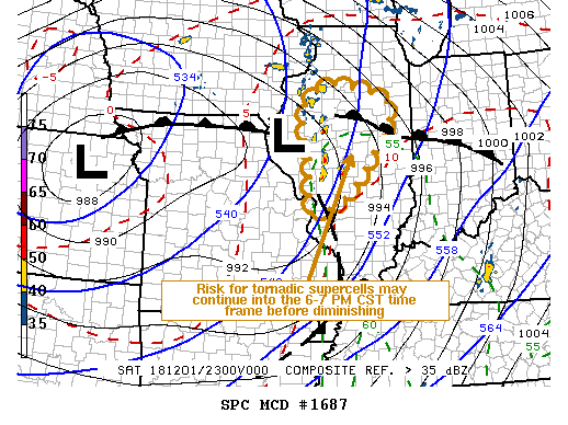 |
| SPC Mesoscale Discussion #1684 (see link for more details) | SPC Mesoscale Discussion #1687 (see link for more details) |
SPC - Storm Prediction Center
 |
Media use of NWS Web News Stories is encouraged! Please acknowledge the NWS as the source of any news information accessed from this site. |
|