Overview
|
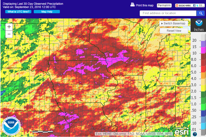
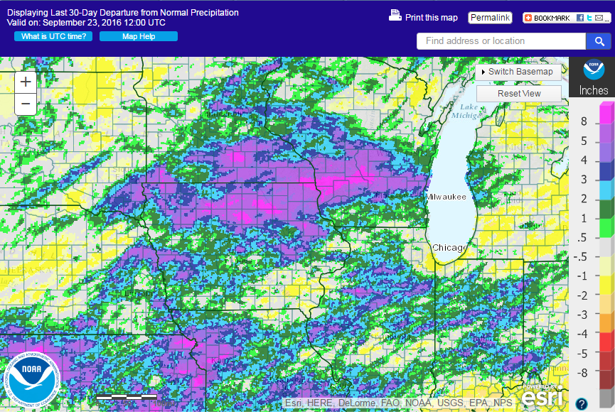
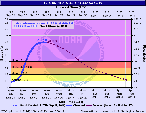
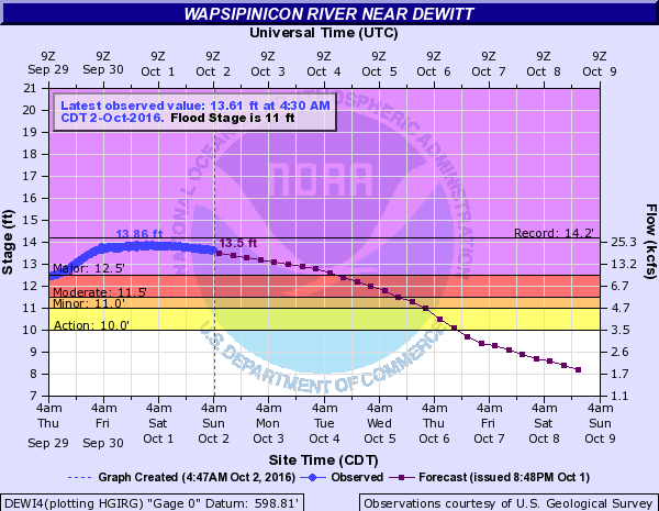
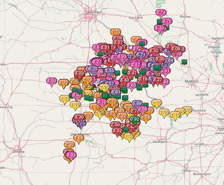
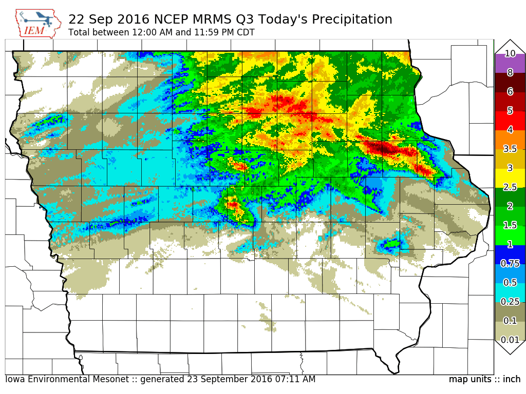
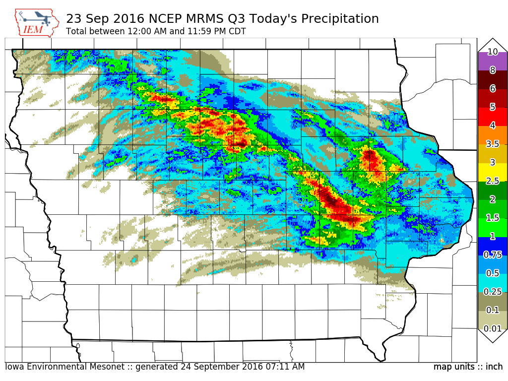
Torrential rainfall, flash flooding, and major river flooding occurred during the last two weeks of September across northeast Iowa, eastern Iowa, and along the Mississippi river. Many locations saw rivers rise to levels not seen since the 2008 flood. Heavy rain fell in the Cedar, Iowa, Wapsipinicon, and Maquoketa river basins over northern Iowa and western Wisconsin between Wed Sept 21st and Friday Sept 23rd. Many towns along these rivers and their tributaries were inundated with flood waters. The 2nd highest crest was recorded on the Cedar River at Cedar Rapids, with a preliminary crest of 21.97' on Sep 27th. The Wapsipinicon river at De Witt also recorded a preliminary crest of 13.86' on Sept 30th, putting it at the 4th highest crest on record. |
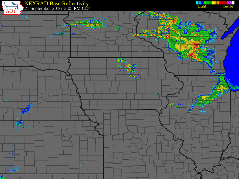
 September 2016 Rainfall Amounts Across the Midwest |
 |
 |
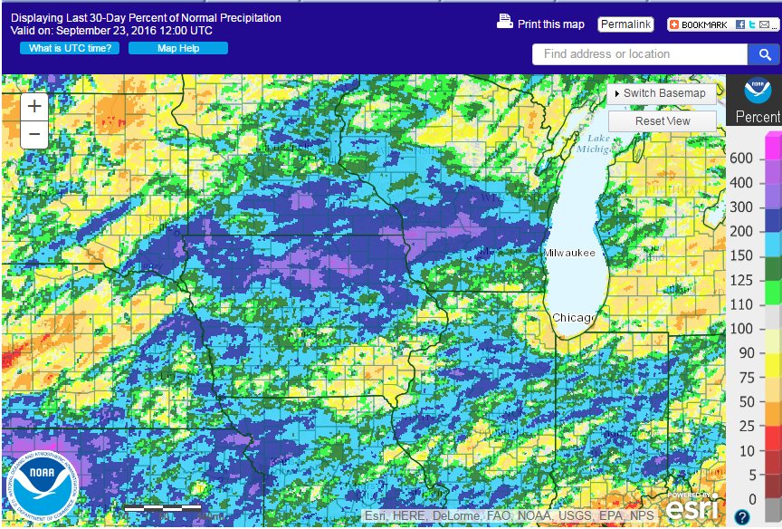 |
| 30-day Observed Precipitation Ending 9/23/16 | 30-day Departure from Normal Precipitation Ending 9/23/16 | 30-day Percent of Normal Precipitation Ending 9/23/16 |
Flooding
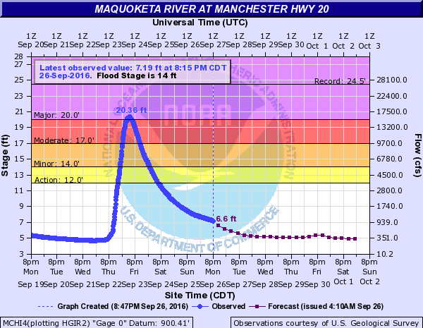
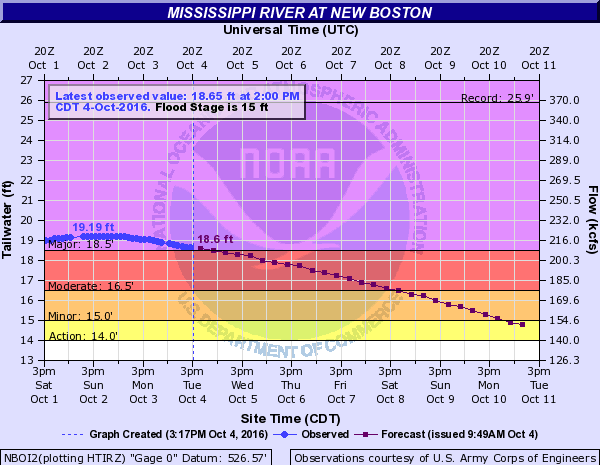
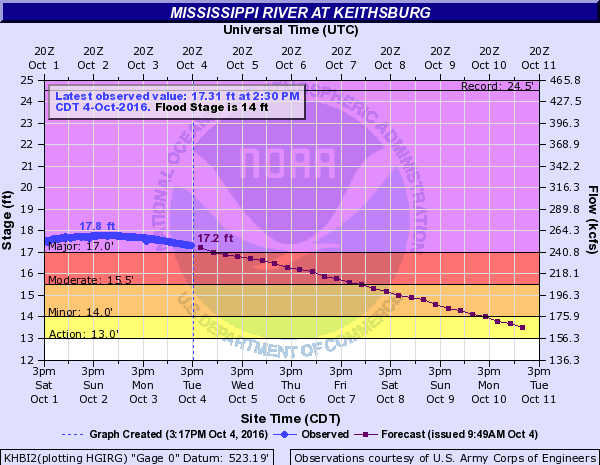
Minor to major flooding was observed on several rivers across the area. Below are some hydrographs of locations that experienced flooding.
Hydrographs
| MAJOR FLOODING | |||
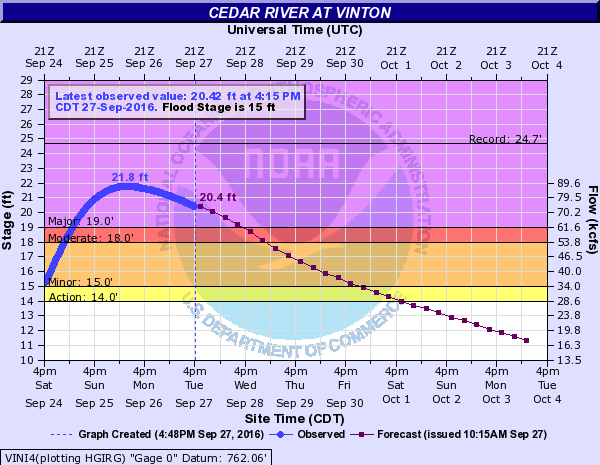
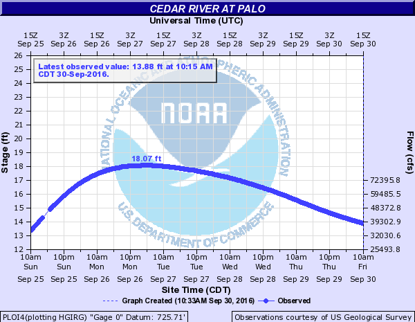
| Cedar River | |||
 |
 |
 |
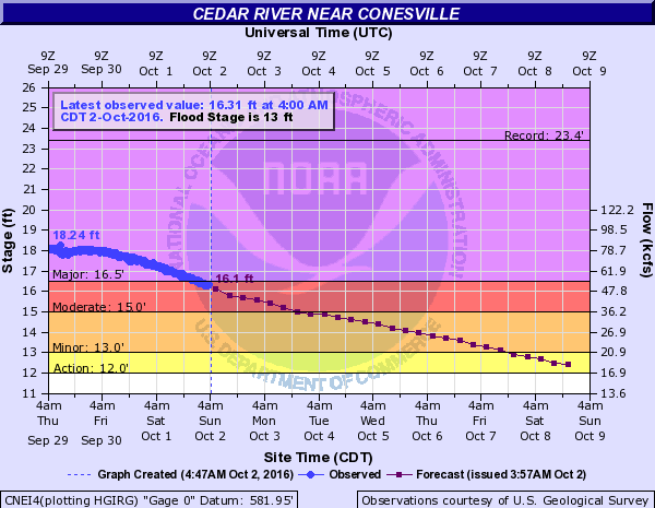 |
| Vinton, IA | Palo, IA (not a forecast point) | Cedar Rapids, IA | Conesville, IA |
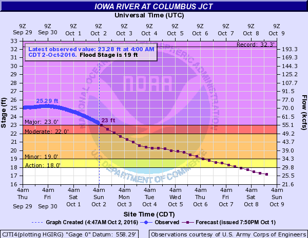
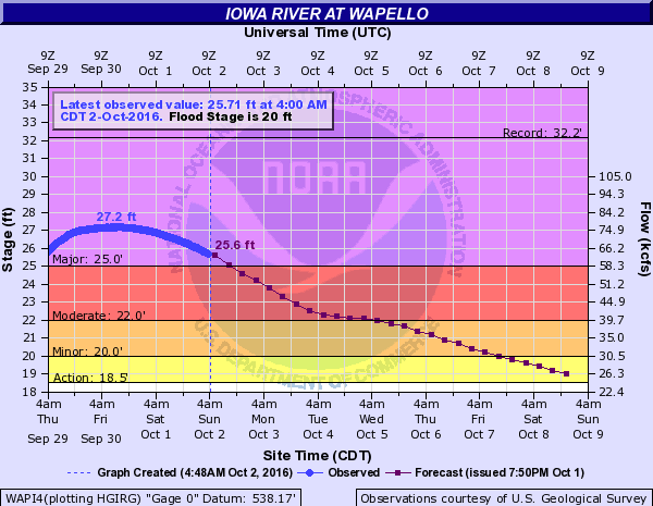
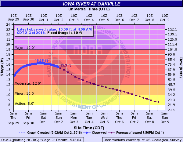
| Iowa River | |||
 |
 |
||
| Columbus Jct, IA | Wapello, IA | ||
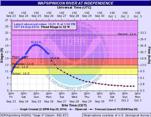
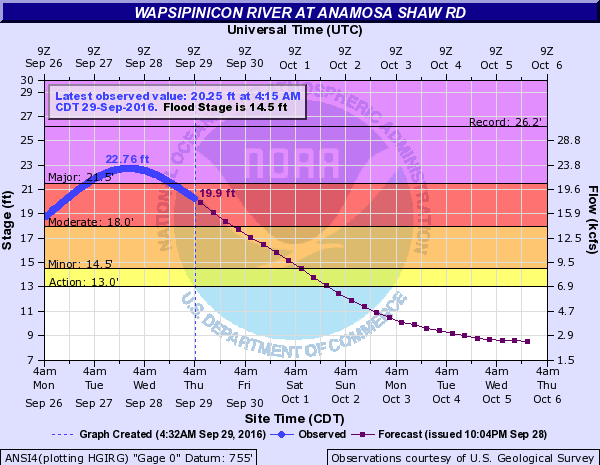
| Wapsipinicon River | |||
 |
 |
 |
|
| Independence, IA | Anamosa, IA | De Witt, IA | |
| Maquoketa River | |||
 |
|||
| Manchester, IA | |||
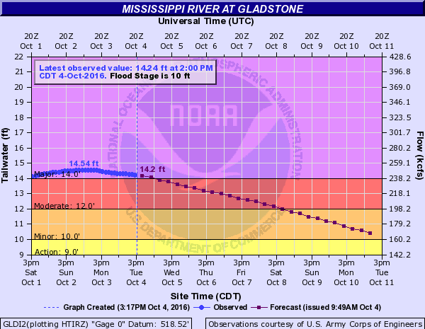
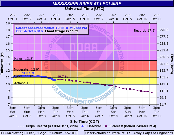
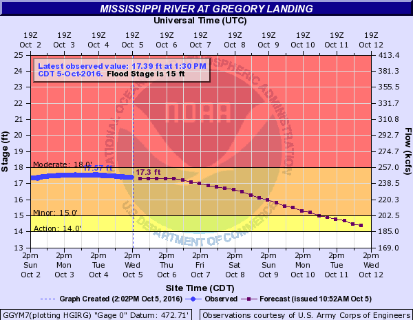
| Mississippi River | |||
 |
 |
 |
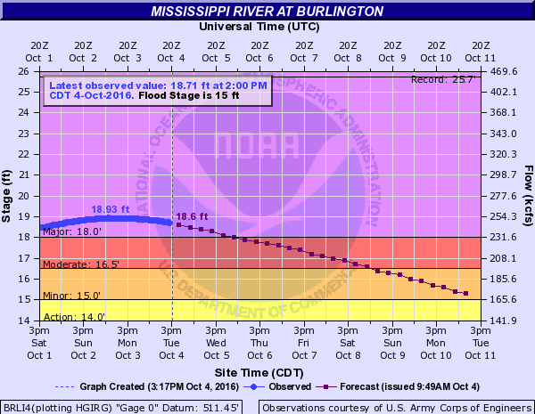 |
| New Boston, IL | Keithsburg, IL | Gladstone, IL | Burlington, IA |
| MODERATE FLOODING | |||
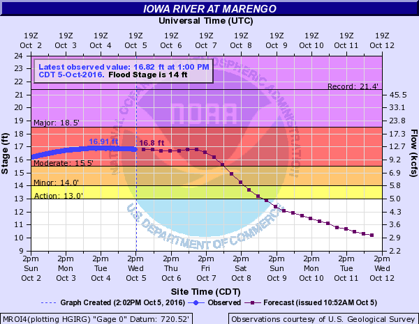
| Iowa River | |||
 |
 |
||
| Marengo, IA | Oakville, IA | ||
| Mississippi River | |||
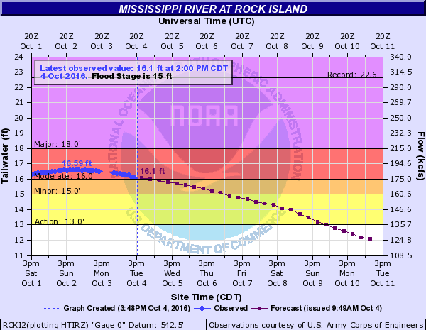 |
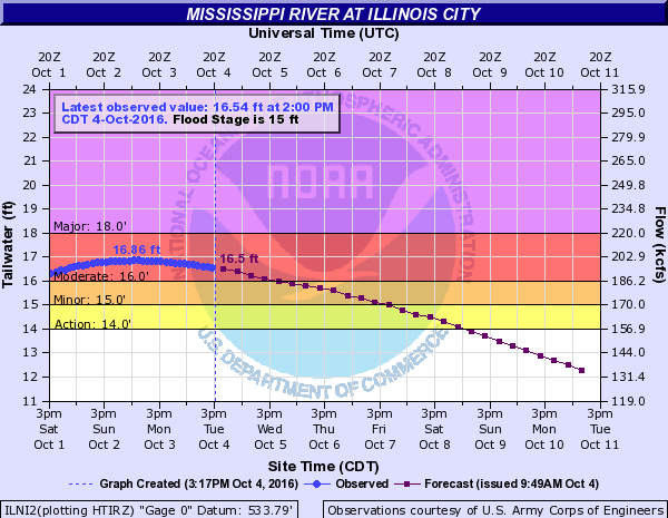 |
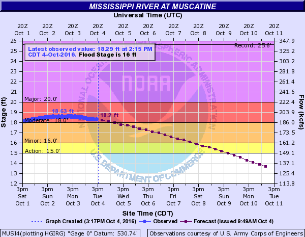 |
|
| Rock Island, IL | Illinois City, IL | Muscatine, IA | |
| MINOR FLOODING | |||
| Maquoketa River | |||
 |
|||
| Maquoketa, IA | |||
| Mississippi River | |||
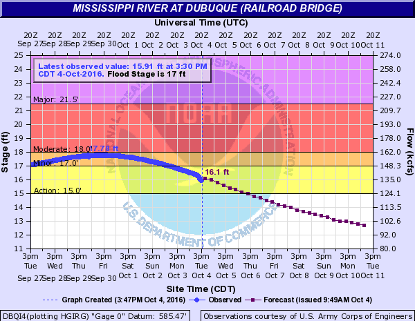 |
 |
 |
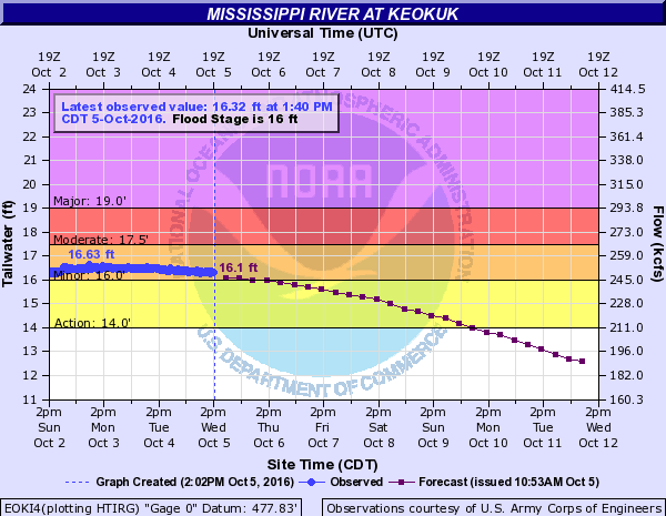 |
| Dubuque, IA | Camanche, IA | Le Claire, IA | Keokuk, IA |
 |
|||
| Gregory Landing, MO | |||
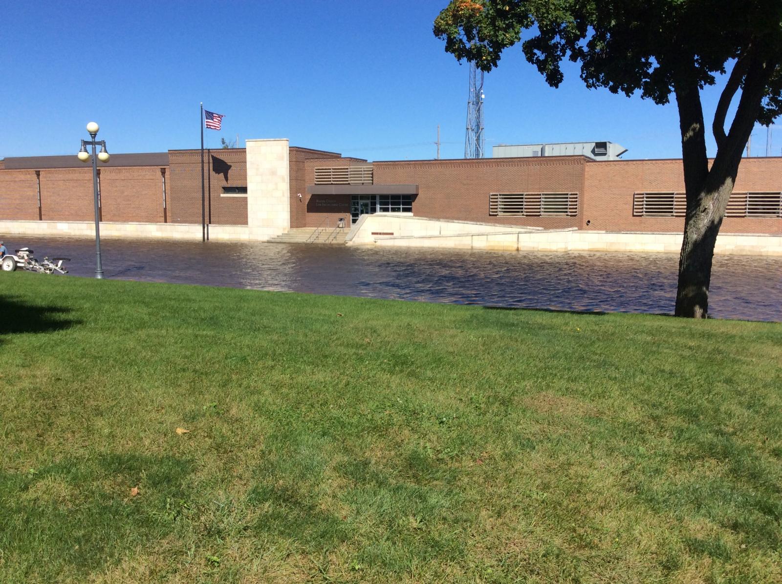
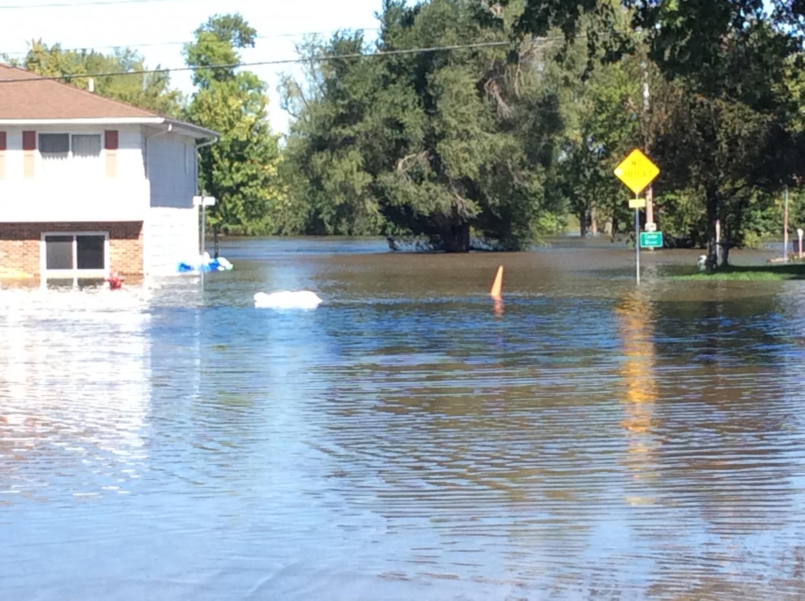
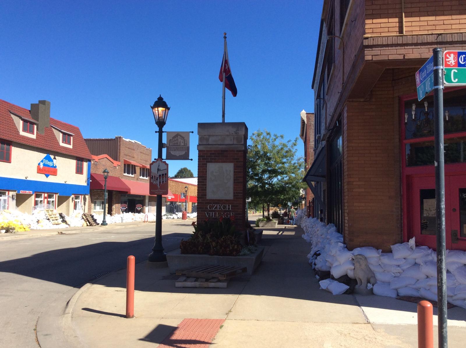
Photos (more to be added)
 |
 |
 |
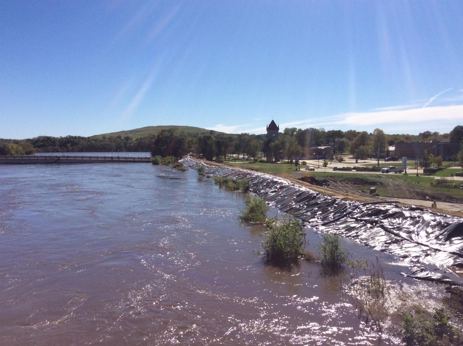 |
| Benton County EM Offices surrounded by Cedar River water | Inundated streets and homes in Vinton, IA | Flood Preparations in Czech Village in Cedar Rapids, IA | The Cedar River from the 12th Ave Bridge in Cedar Rapids near crest time. |
Rain Reports/Maps
| Interactive Map | Radar Precip Estimates 9/21/16 |
Radar Precip Estimates 9/22/16 |
Radar Precip Estimates 9/23/16 |
 |
 |
 |
 |
PRELIMINARY LOCAL STORM REPORT...SUMMARY
NATIONAL WEATHER SERVICE QUAD CITIES IA IL
1024 AM CDT FRI SEP 23 2016

..TIME...   ...EVENT...      ...CITY LOCATION...     ...LAT.LON...
..DATE...   ....MAG....      ..COUNTY LOCATION..ST.. ...SOURCE....
            ..REMARKS..

1028 PM     FLASH FLOOD      DYERSVILLE              42.48N 91.12W
09/22/2016                   DUBUQUE            IA   EMERGENCY MNGR

            FLASH FLOODING FLOWING INTO HOMES BASEMENT. FIRE
            DEPARTMENT IS RESPONDING TO THE INCIDENT.

1208 AM     FLASH FLOOD      WORTHINGTON             42.40N 91.12W
09/23/2016                   DUBUQUE            IA   EMERGENCY MNGR

            EM REPORTS A COUPLE OF WASHED OUT ROADS IN SOUTHWEST
            DUBUQUE COUNTY FROM FLOODING. MOST CREEKS HAVE RETURNED
            TO THEIR BANKS AT THE CURRENT TIME.

0513 AM     FLASH FLOOD      CEDAR RAPIDS            41.97N 91.67W
09/23/2016                   LINN               IA   LAW ENFORCEMENT

            ELLIS ROAD WEST OF EDGEWOOD ROAD IS UNDER WATER AND
            IMPASSABLE

0602 AM     HEAVY RAIN       1 E INDEPENDENCE        42.47N 91.88W
09/23/2016  M2.25 INCH       BUCHANAN           IA   TRAINED SPOTTER

            24-HOUR RAINFALL

0615 AM     HEAVY RAIN       WSW QUASQUETON          42.40N 91.76W
09/23/2016  E2.20 INCH       BUCHANAN           IA   COCORAHS

            24 HOUR RAINFALL. OBSERVED CREEKS BETWEEN QUASQUETON AND
            CENTER POINT ARE FULL. STANDING WATER IN DITCHES.

0642 AM     HEAVY RAIN       WILLIAMSBURG            41.67N 92.01W
09/23/2016  M1.60 INCH       IOWA               IA   CO-OP OBSERVER

            24-HOUR RAINFALL

0700 AM     HEAVY RAIN       BELLE PLAINE            41.90N 92.27W
09/23/2016  M1.85 INCH       BENTON             IA   CO-OP OBSERVER

            24-HOUR RAINFALL

0700 AM     HEAVY RAIN       COGGON                  42.28N 91.53W
09/23/2016  M2.70 INCH       LINN               IA   CO-OP OBSERVER

            24-HOUR RAINFALL

0700 AM     HEAVY RAIN       MARENGO                 41.80N 92.07W
09/23/2016  M2.25 INCH       IOWA               IA   CO-OP OBSERVER

            24-HOUR RAINFALL

0700 AM     HEAVY RAIN       IOWA CITY               41.66N 91.54W
09/23/2016  M1.20 INCH       JOHNSON            IA   CO-OP OBSERVER

            24-HOUR RAINFALL

0700 AM     HEAVY RAIN       CASCADE                 42.30N 91.01W
09/23/2016  M1.50 INCH       DUBUQUE            IA   CO-OP OBSERVER

            24-HOUR RAINFALL

0740 AM     HEAVY RAIN       VINTON                  42.16N 92.03W
09/23/2016  M2.20 INCH       BENTON             IA   CO-OP OBSERVER

            24-HOUR RAINFALL

0740 AM     HEAVY RAIN       1 S SWISHER             41.82N 91.69W
09/23/2016  M3.50 INCH       JOHNSON            IA   TRAINED SPOTTER

            RAINFALL SINCE 3AM

0740 AM     HEAVY RAIN       MANCHESTER              42.49N 91.46W
09/23/2016  M5.69 INCH       DELAWARE           IA   CO-OP OBSERVER

            24-HOUR TOTAL

0740 AM     HEAVY RAIN       1 SSE CEDAR RAPIDS      41.95N 91.66W
09/23/2016  M1.75 INCH       LINN               IA   TRAINED SPOTTER

            RAINFALL SINCE 240AM

0755 AM     HEAVY RAIN       SWISHER                 41.84N 91.70W
09/23/2016  M3.43 INCH       JOHNSON            IA   COCORAHS

            RAINFALL OVER PAST 5 HOURS

0819 AM     HEAVY RAIN       4 N MARENGO             41.85N 92.07W
09/23/2016  M2.50 INCH       IOWA               IA   TRAINED SPOTTER

            RAINFALL SINCE 3AM

0912 AM     HEAVY RAIN       NE BERTRAM              41.96N 91.53W
09/23/2016  M2.50 INCH       LINN               IA   TRAINED SPOTTER

            RAIN HAS ENDED

0943 AM     FLASH FLOOD      W AMANA                 41.80N 91.87W
09/23/2016                   IOWA               IA   EMERGENCY MNGR

            FLOODING CONINUES ALONG PRICE CREEK IN THE AMANA COLONIES


0955 AM     HEAVY RAIN       3 ENE MARION            42.05N 91.54W
09/23/2016  M0.92 INCH       LINN               IA   TRAINED SPOTTER

            24 HOUR RAINFALL TOTAL
|
|||
|
|
|||
 |
Media use of NWS Web News Stories is encouraged! Please acknowledge the NWS as the source of any news information accessed from this site. |
|