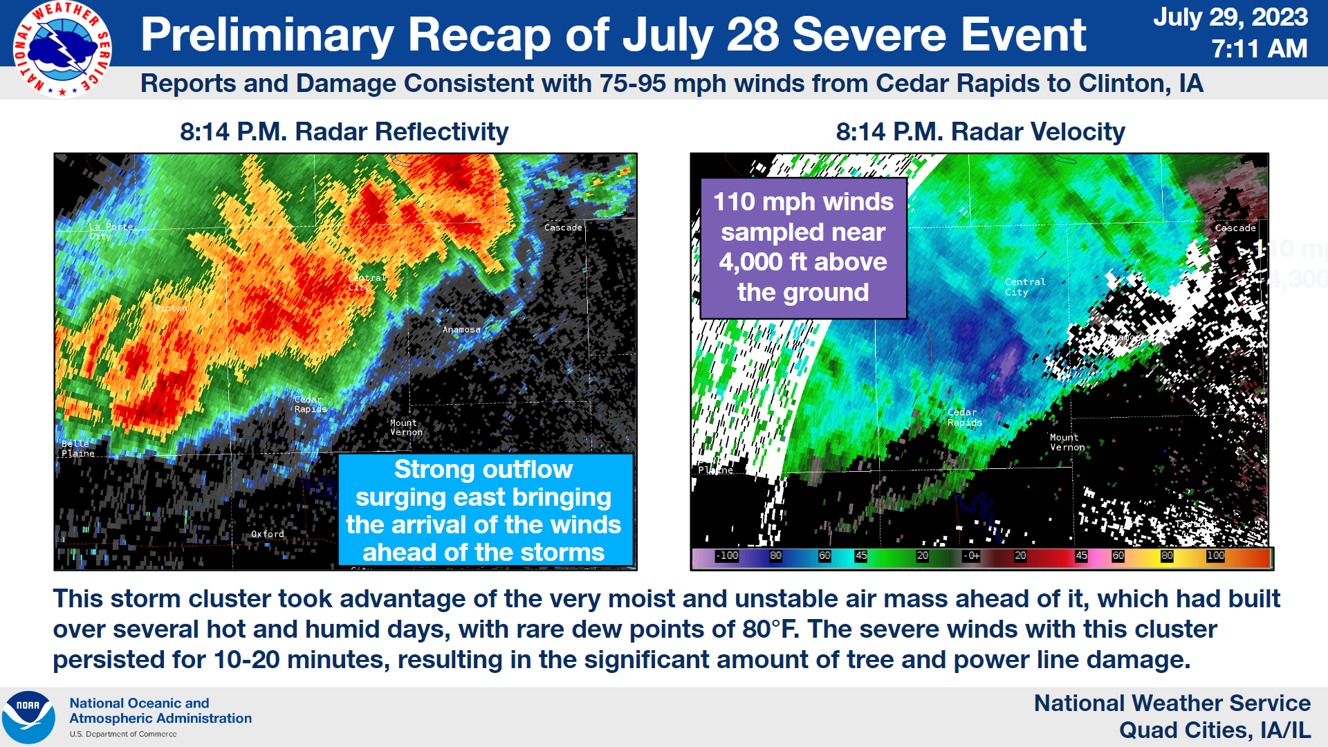
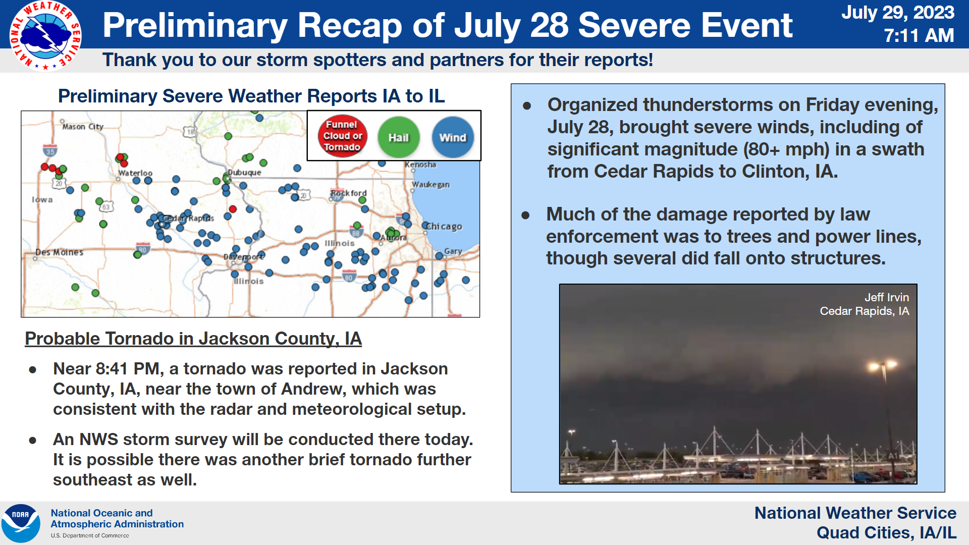
Overview (Updated 8/1/23)
|
Quick Links |
|
Event Summary
|
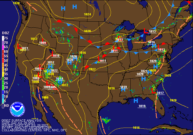 Surface Analysis (WPC) Surface Analysis (WPC) |
 |
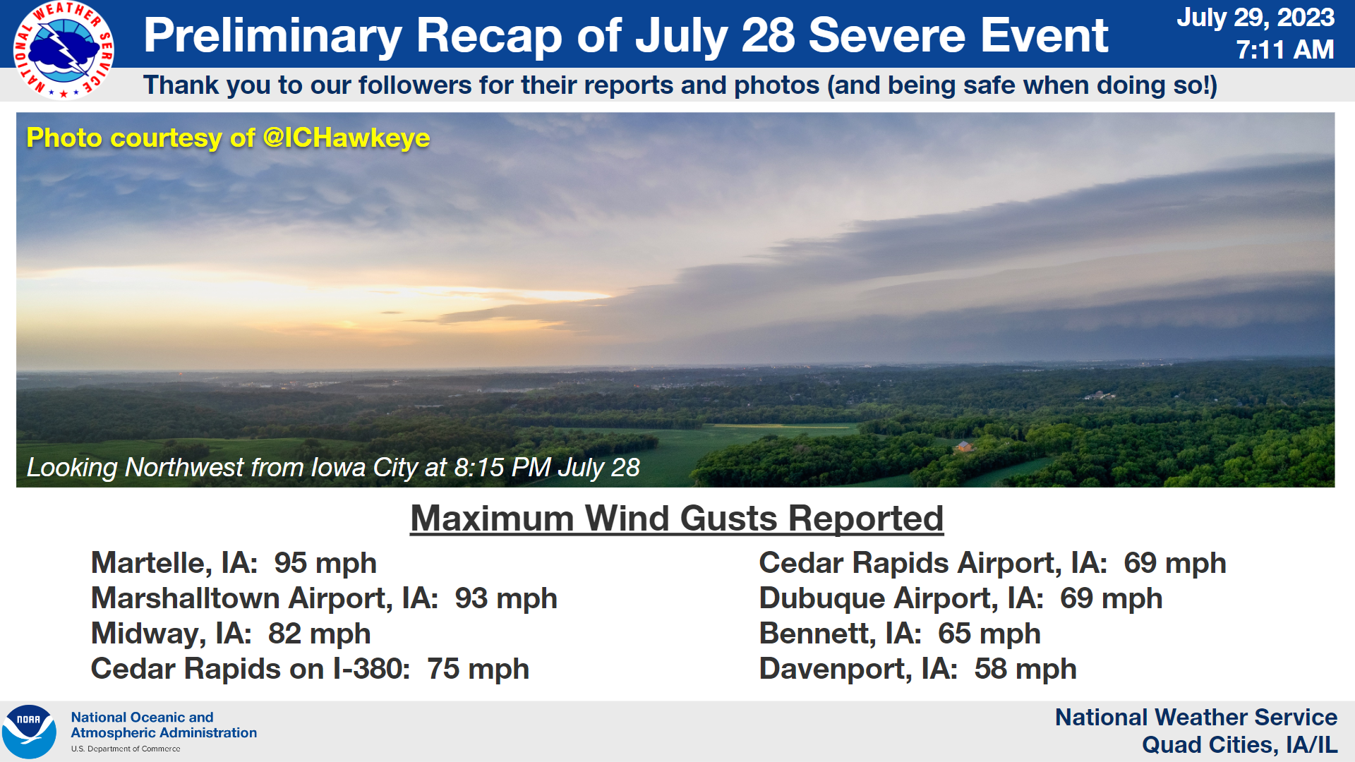 |
| Fast Facts Infographic | Observed Maximum Wind Gusts Infographic |
Tornadoes
|
Tornado #1 - Clinton, IA
Track Map 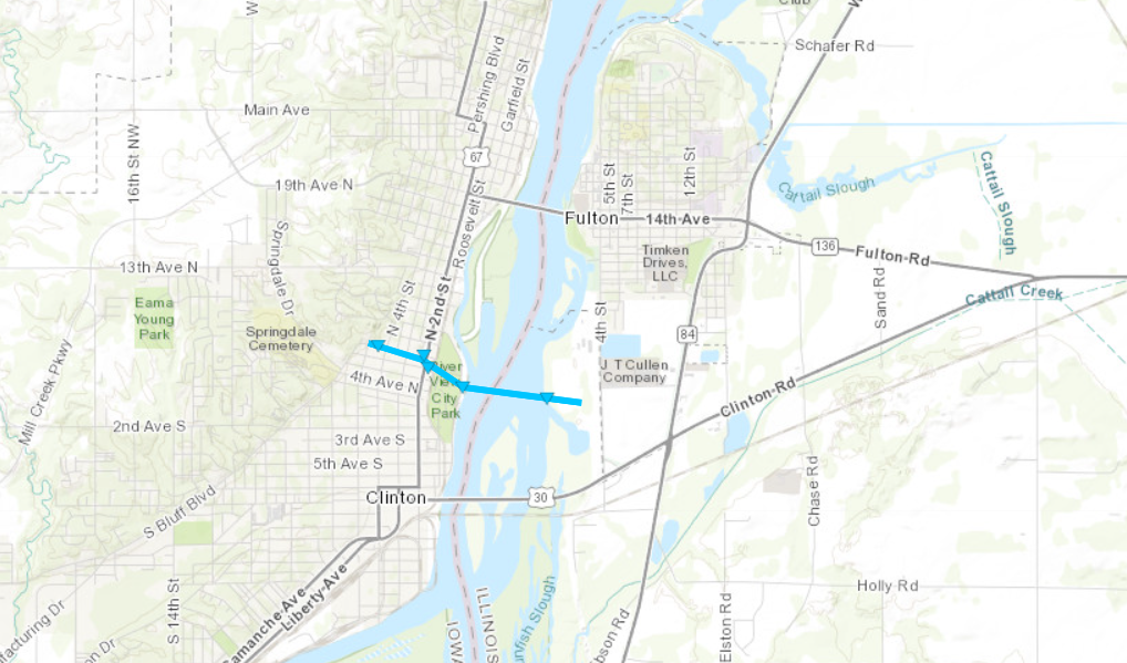 
Downloadable KMZ File |
||||||||||||||||
The Enhanced Fujita (EF) Scale classifies tornadoes into the following categories:
| EF0 Weak 65-85 mph |
EF1 Moderate 86-110 mph |
EF2 Significant 111-135 mph |
EF3 Severe 136-165 mph |
EF4 Extreme 166-200 mph |
EF5 Catastrophic 200+ mph |
 |
|||||
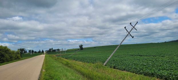
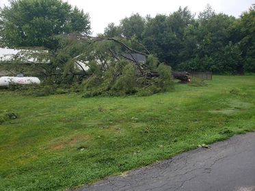
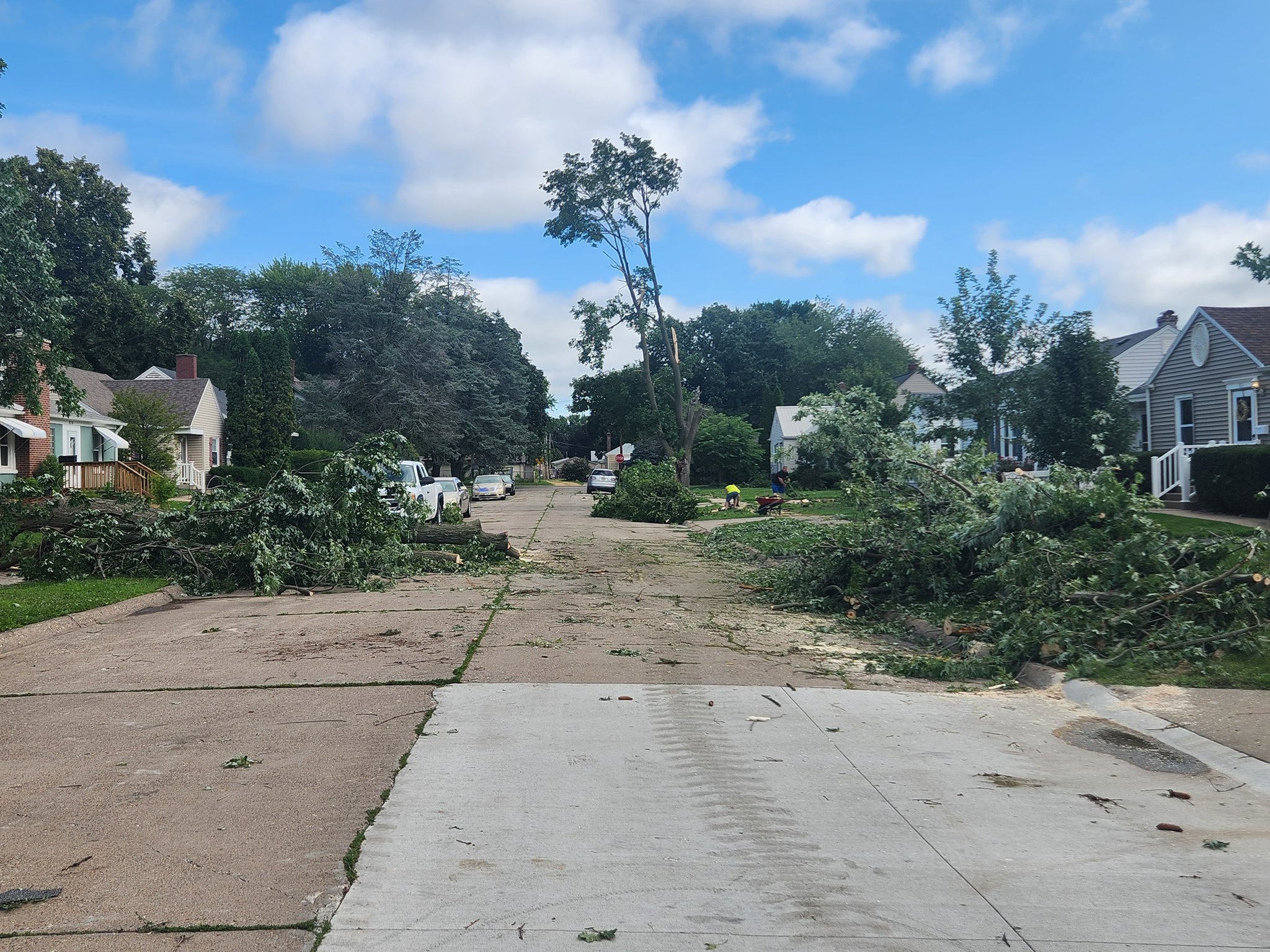
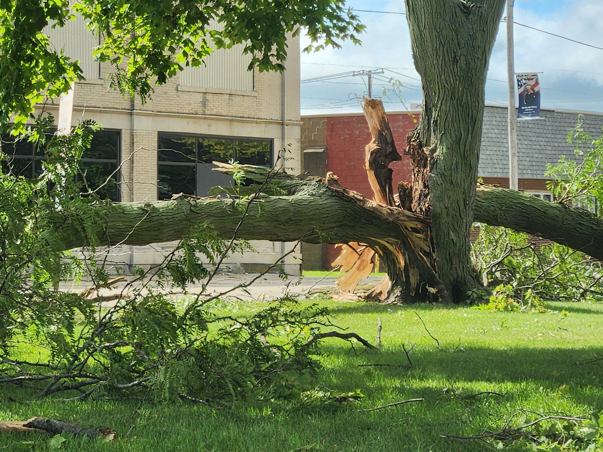
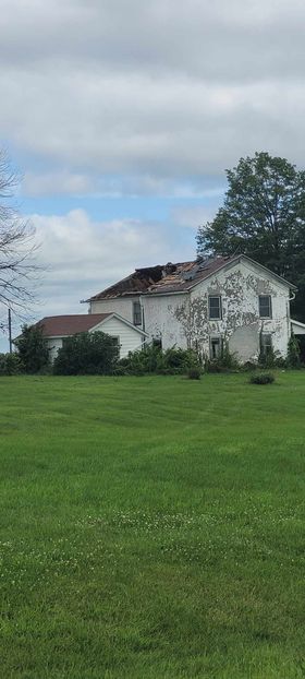
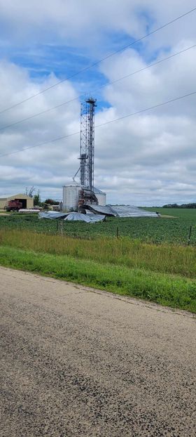
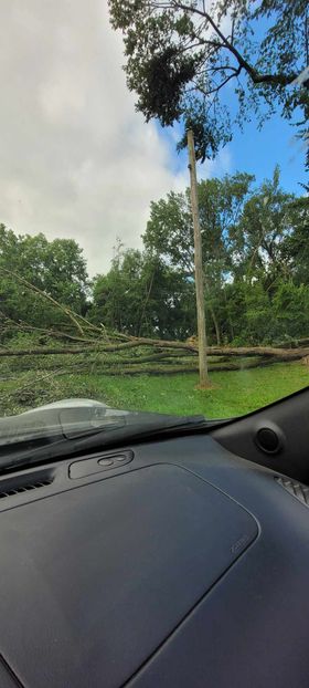
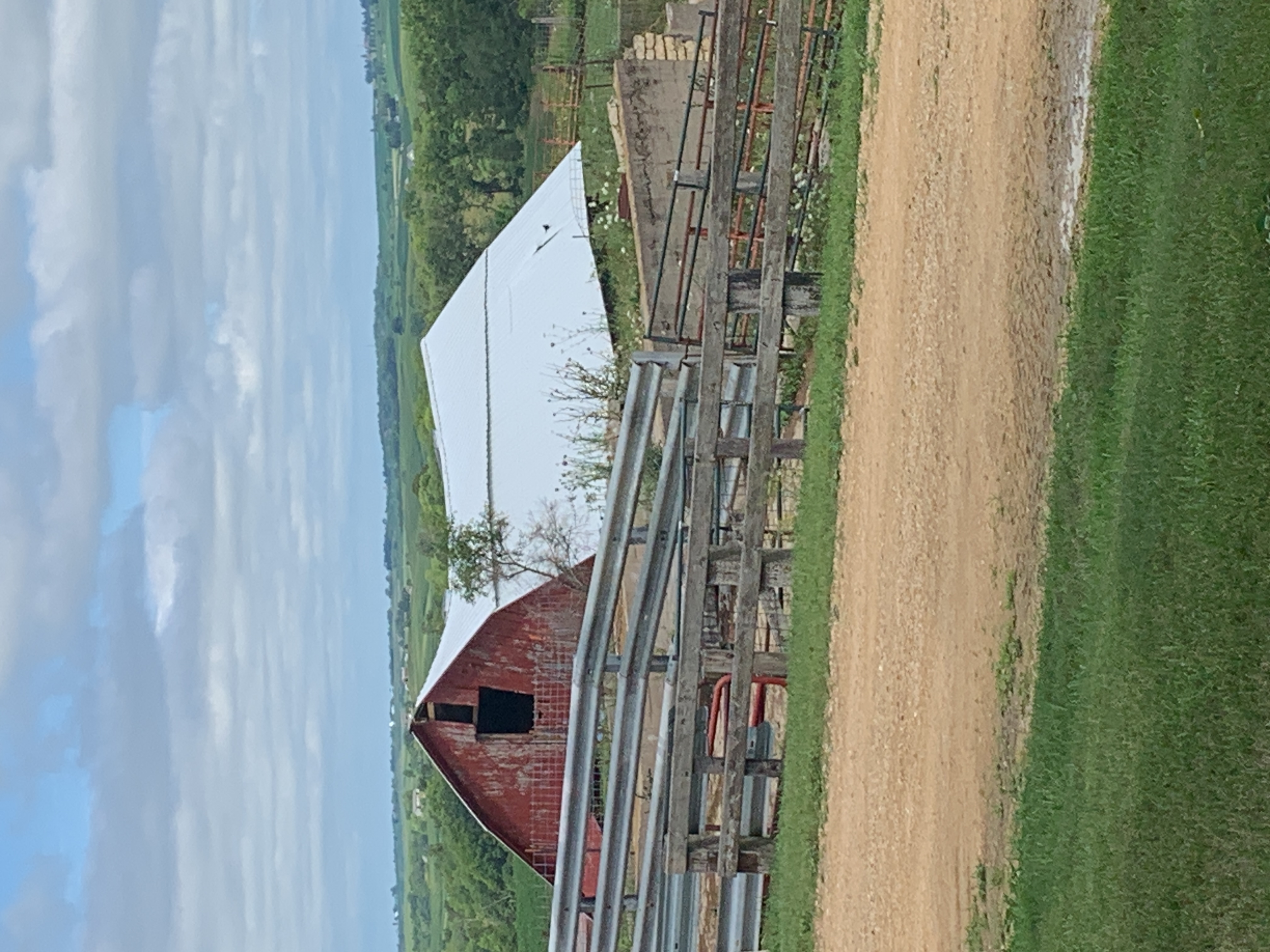
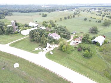
Photos & Video
 |
 |
 |
 |
| Lena, IL (Brandon McGrew) |
Morrison, IL (Ben Gooley) |
Clinton, IA (David French) |
Clinton, IA (David French) |
 |
 |
 |
 |
| Lena, IL (Brandon McGrew) |
Lena, IL (Brandon McGrew) |
Lena, IL (Brandon McGrew) |
Andrew, IA (NWS Storm Survey) |
 |
|||
| Delaware County, IA (Jeff Elliot) |
Caption (source) |
Caption (source) |
Caption (source) |
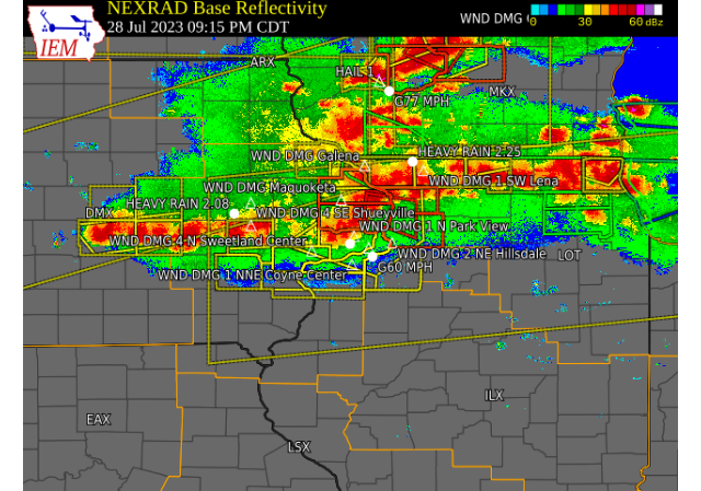
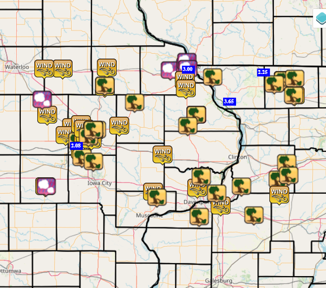
Storm Reports
| Storm Reports 7/28 | SPC Severe Weather Event: July 28, 2023 | ||
 |
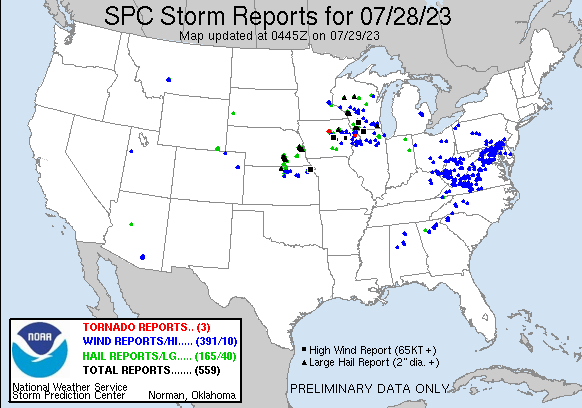 |
Preliminary Local Storm Report...Summary
National Weather Service Quad Cities IA IL
516 AM CDT Sat Jul 29 2023
..TIME... ...EVENT... ...CITY LOCATION... ...LAT.LON...
..DATE... ....MAG.... ..COUNTY LOCATION..ST.. ...SOURCE....
..REMARKS..
0716 PM Tstm Wnd Gst 1 WSW Independence 42.48N 91.89W
07/28/2023 M70 MPH Buchanan IA Mesonet
Corrects previous tstm wnd gst report from 1
N Independence. reported on Davis weather
station.
0735 PM Tstm Wnd Dmg Jesup 42.48N 92.07W
07/28/2023 Buchanan IA Trained Spotter
several 6 inch diameter trees down.
0735 PM Tstm Wnd Gst Jesup 42.48N 92.07W
07/28/2023 E60 MPH Buchanan IA Trained Spotter
0739 PM Hail 1 S Edmore 42.53N 90.68W
07/28/2023 M1.00 inch Dubuque IA Broadcast Media
Reported at Dubuque County Fairgrounds.
0740 PM Hail 1 NE Rockdale 42.48N 90.67W
07/28/2023 M0.88 inch Dubuque IA Trained Spotter
South side of Dubuque near Highway 61.
0740 PM Tstm Wnd Gst 1 SW Vinton 42.15N 92.04W
07/28/2023 M53 MPH Benton IA Mesonet
0745 PM Hail Mount Auburn 42.26N 92.09W
07/28/2023 E0.88 inch Benton IA Trained Spotter
0749 PM Tstm Wnd Gst Manchester 42.49N 91.46W
07/28/2023 E70 MPH Delaware IA Trained Spotter
0753 PM Tstm Wnd Gst Ryan 42.35N 91.48W
07/28/2023 M61 MPH Delaware IA Emergency Mngr
0758 PM Tstm Wnd Gst Palo 42.06N 91.80W
07/28/2023 E70 MPH Linn IA Public
0759 PM Tstm Wnd Gst Atkins 42.00N 91.86W
07/28/2023 E60 MPH Benton IA Public
0800 PM Tstm Wnd Dmg Ryan 42.36N 91.48W
07/28/2023 Delaware IA Emergency Mngr
Corrects previous tstm wnd dmg report from
Ryan. Outbuilding damage in Ryan.
0802 PM Tstm Wnd Gst 2 SSW Midway 42.08N 91.71W
07/28/2023 M82 MPH Linn IA Trained Spotter
0804 PM Tstm Wnd Gst 2 WNW Marion 42.04N 91.63W
07/28/2023 E65 MPH Linn IA Trained Spotter
0805 PM Tstm Wnd Gst Hiawatha 42.05N 91.68W
07/28/2023 E90 MPH Linn IA Trained Spotter
0807 PM Tstm Wnd Dmg 4 W Cedar Rapids 41.96N 91.74W
07/28/2023 Linn IA Public
Tree limbs broken; Power poles broken,
shingles blown off part of the roof.
0809 PM Tstm Wnd Dmg 2 WNW Marion 42.04N 91.62W
07/28/2023 Linn IA Public
Report from mPING: 1-inch tree limbs broken;
Shingles blown off.
0810 PM Tstm Wnd Gst Cedar Rapids 41.98N 91.68W
07/28/2023 M58 MPH Linn IA Dept of Highways
IADOT RWIS.
0810 PM Tstm Wnd Gst 3 NNE Cedar Rapids 42.01N 91.66W
07/28/2023 E80 MPH Linn IA Trained Spotter
trees limbs down.. power out...
0810 PM Tstm Wnd Gst Cedar Rapids 41.98N 91.67W
07/28/2023 M75 MPH Linn IA Mesonet
Mesonet station RCDI4 in Cedar Rapids along
I-380.
0811 PM Tstm Wnd Gst Hiawatha 42.05N 91.68W
07/28/2023 E90 MPH Linn IA Trained Spotter
90 mph winds lasting 6 minutes and still
ongoing. Zero visibility.
0815 PM Tstm Wnd Gst Marion 42.03N 91.59W
07/28/2023 M66 MPH Linn IA Mesonet
0816 PM Tstm Wnd Gst Cedar Rapids Airport 41.89N 91.71W
07/28/2023 M69 MPH Linn IA ASOS
0818 PM Tstm Wnd Gst 1 SSW Fairview 42.07N 91.34W
07/28/2023 M58 MPH Jones IA Dept of Highways
IADOT RWIS.
0818 PM Tstm Wnd Dmg Monticello 42.24N 91.19W
07/28/2023 Jones IA Law Enforcement
Several trees and numerous large branches
downed across town.
0820 PM Tstm Wnd Gst 3 E Cedar Rapids 41.97N 91.61W
07/28/2023 M72 MPH Linn IA Trained Spotter
0820 PM Tstm Wnd Dmg 2 ENE Marion 42.04N 91.56W
07/28/2023 Linn IA Trained Spotter
damage to mobile homes.
0820 PM Tstm Wnd Gst Marion 42.04N 91.59W
07/28/2023 E90 MPH Linn IA Trained Spotter
0822 PM Tstm Wnd Gst Martelle 42.02N 91.36W
07/28/2023 M95 MPH Jones IA Broadcast Media
Relayed from a public viewer measured on
their personal weather station.
0822 PM Tstm Wnd Gst 2 NNW Lisbon 41.94N 91.40W
07/28/2023 M65 MPH Linn IA Mesonet
Mesonet station DVI09350.
0823 PM Tstm Wnd Dmg Anamosa 42.11N 91.28W
07/28/2023 Jones IA Law Enforcement
Multiple trees downed.
0824 PM Tstm Wnd Dmg 2 ENE Cedar Rapids 41.99N 91.64W
07/28/2023 Linn IA Public
Report from mPING: 3-inch tree limbs broken;
Power poles broken.
0828 PM Tstm Wnd Gst 2 S Mc Connell 42.40N 89.74W
07/28/2023 E80 MPH Stephenson IL Trained Spotter
0835 PM Tstm Wnd Dmg Wyoming 42.06N 91.00W
07/28/2023 Jones IA Law Enforcement
Powerlines downed througout town, including
one onto a mobile home.
0838 PM Tstm Wnd Dmg 2 S Mc Connell 42.40N 89.74W
07/28/2023 Stephenson IL Trained Spotter
Large tree branch blown down on a boat.
0839 PM Tstm Wnd Gst Lowden 41.86N 90.92W
07/28/2023 E71 MPH Cedar IA Mesonet
union pacific railroad mesonet station.
0840 PM Tstm Wnd Dmg Clarence 41.88N 91.06W
07/28/2023 Cedar IA Law Enforcement
Large tree downed on 5th Avenue on the south
side of town.
0840 PM Tstm Wnd Dmg Swisher 41.84N 91.70W
07/28/2023 Johnson IA Public
Several trees down in town, time estimated
from radar.
0841 PM Tornado Andrew 42.15N 90.59W
07/28/2023 Jackson IA Broadcast Media
Confirmed tornado by TV6 employee crossed
Highway 61 near Andrew.
0841 PM Tstm Wnd Dmg Monticello 42.24N 91.19W
07/28/2023 Jones IA Public
Corrects previous tstm wnd dmg report from
Monticello. Trees down throughout town.
0842 PM Tstm Wnd Gst 1 E Dubuque Regional Ar 42.40N 90.70W
07/28/2023 M69 MPH Dubuque IA ASOS
Corrects previous tstm wnd gst report from 1
E Dubuque Regional Arpt.
0848 PM Tstm Wnd Dmg Tipton 41.77N 91.13W
07/28/2023 Cedar IA Law Enforcement
Numerous trees downed across town.
0849 PM Tstm Wnd Gst 3 N Zwingle 42.34N 90.69W
07/28/2023 M59 MPH Dubuque IA Emergency Mngr
0850 PM Tstm Wnd Gst 2 NNW Bennett 41.77N 90.99W
07/28/2023 M65 MPH Cedar IA Mesonet
Mesonet station DVI11039.
0851 PM Tstm Wnd Gst Freeport 42.29N 89.63W
07/28/2023 E60 MPH Stephenson IL Trained Spotter
0851 PM Tstm Wnd Dmg 2 ENE Red Oak 42.41N 89.63W
07/28/2023 Stephenson IL Public
Report from mPING: Trees uprooted or
snapped; Roof blown off, time estimated from
radar.
0855 PM Tstm Wnd Gst 1 ESE Wilton 41.59N 91.01W
07/28/2023 E60 MPH Muscatine IA Trained Spotter
0856 PM Tstm Wnd Dmg Freeport 42.29N 89.64W
07/28/2023 Stephenson IL Trained Spotter
several 5 inch diameter tree limbs down near
intersection of Harlem and Empire, time
estimated from radar.
0856 PM Tstm Wnd Dmg Wheatland 41.83N 90.84W
07/28/2023 Clinton IA Law Enforcement
Trees and powerlines downed.
0858 PM Tstm Wnd Dmg Andrew 42.15N 90.59W
07/28/2023 Jackson IA Fire Dept/Rescue
Trees down Highway 62 in Andrew. Possible
tornado.
0900 PM Tstm Wnd Dmg Galena 42.42N 90.43W
07/28/2023 Jo Daviess IL Public
Several trees down within the county, with
trees down over wires in Galena. Time
estimated from radar.
0905 PM Tstm Wnd Dmg Maquoketa 42.07N 90.67W
07/28/2023 Jackson IA Trained Spotter
3 - 4 inch limbs down in City of Maquoketa.
0905 PM Tstm Wnd Dmg 4 SE Shueyville 41.81N 91.59W
07/28/2023 Johnson IA Emergency Mngr
Several trees down at Sandy Beach
Campground. Time estimated from radar.
0906 PM Rain 1 NE Fairfax 41.93N 91.76W
07/28/2023 M2.08 inch Linn IA Trained Spotter
0907 PM Tstm Wnd Dmg 4 N Sweetland Center 41.55N 90.97W
07/28/2023 Muscatine IA Public
Report from mPING: 1-inch tree limbs broken;
Shingles blown off.
0908 PM Tstm Wnd Dmg 1 SW Green Island 42.15N 90.33W
07/28/2023 Jackson IA Law Enforcement
Large tree downed.
0912 PM Tstm Wnd Gst Davenport Municipality 41.62N 90.58W
07/28/2023 M58 MPH Scott IA ASOS
DVN ASOS.
0913 PM Tstm Wnd Dmg Marion 42.04N 91.59W
07/28/2023 Linn IA Law Enforcement
Updates previous report from Marion. Many
large branches downed as well as some wired
downed.
0914 PM Tstm Wnd Dmg 1 SW Lena 42.37N 89.83W
07/28/2023 Stephenson IL Public
Report from mPING: 1-inch tree limbs broken;
Shingles blown off.
0915 PM Tstm Wnd Dmg 1 N Park View 41.70N 90.54W
07/28/2023 Scott IA Public
Report from mPING: 1-inch tree limbs broken;
Shingles blown off.
0916 PM Rain Nora 42.46N 89.94W
07/28/2023 M2.25 inch Jo Daviess IL Trained Spotter
rainfall since 8 pm.
0919 PM Tstm Wnd Dmg Clinton 41.84N 90.23W
07/28/2023 Clinton IA Law Enforcement
Trees down throughout the city.
0919 PM Tstm Wnd Dmg Low Moor 41.80N 90.35W
07/28/2023 Clinton IA Law Enforcement
Trees and powerlines downed.
0922 PM Tstm Wnd Gst Colona 41.49N 90.35W
07/28/2023 E60 MPH Henry IL Trained Spotter
Time estimated from radar.
0923 PM Tstm Wnd Dmg Fulton 41.87N 90.16W
07/28/2023 Whiteside IL Law Enforcement
Scattering of trees downed.
0925 PM Tstm Wnd Dmg 1 NNE Coyne Center 41.41N 90.56W
07/28/2023 Rock Island IL Trained Spotter
Tree down on Coyne Center Rd near trailer
park, time estimated from radar.
0925 PM Tstm Wnd Dmg 2 NE Pleasant Valley 41.58N 90.39W
07/28/2023 Scott IA Public
Report from mPING: 3-inch tree limbs broken;
Power poles broken, time estimated from
radar.
0926 PM Tstm Wnd Dmg 2 NE Hillsdale 41.63N 90.15W
07/28/2023 Whiteside IL Public
Report from mPING: 1-inch tree limbs broken;
Shingles blown off.
0931 PM Rain Hanover 42.25N 90.27W
07/28/2023 M3.65 inch Jo Daviess IL Trained Spotter
Rainfall in past 24 hrs, 2 inches in past
hour.
0931 PM Rain 1 NE Rockdale 42.48N 90.67W
07/28/2023 E3.00 inch Dubuque IA Trained Spotter
Started at 6pm.
0933 PM Tstm Wnd Gst 4 SW Williamsburg 41.63N 92.06W
07/28/2023 E70 MPH Iowa IA Emergency Mngr
time estimated from radar.
0940 PM Hail 4 SW Williamsburg 41.63N 92.05W
07/28/2023 E0.88 inch Iowa IA Emergency Mngr
0945 PM Tstm Wnd Dmg 1 WNW Atkinson 41.42N 90.03W
07/28/2023 Henry IL Emergency Mngr
Multiple power lines and tree limbs down
between Geneseo and Annawan.
0954 PM Tstm Wnd Gst 4 E Yorktown 41.57N 89.78W
07/28/2023 M50 MPH Bureau IL Mesonet
1004 PM Tstm Wnd Dmg Walnut 41.56N 89.59W
07/28/2023 Bureau IL Law Enforcement
Large limbs down.
1032 PM Tstm Wnd Dmg 1 N Muscatine 41.43N 91.07W
07/28/2023 Muscatine IA Fire Dept/Rescue
Tree downed onto a power line and likely a
cause of a house catching fire.
1040 PM Tstm Wnd Dmg Hennepin 41.26N 89.32W
07/28/2023 Putnam IL Public
8 inch tree snapped near sheriff office, 2-3
inch tree limbs down. Time estimated from
radar.
1200 AM Rain Dubuque Regional Arpt 42.40N 90.70W
07/29/2023 M2.53 inch Dubuque IA ASOS
ASOS station KDBQ July 28th evening total.
1200 AM Rain 1 WNW Galena Territory 42.41N 90.35W
07/29/2023 M3.05 inch Jo Daviess IL Mesonet
Mesonet station CW7485 July 28th evening
total.
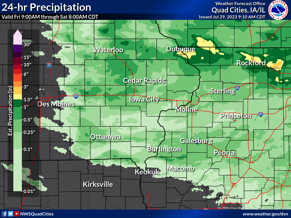
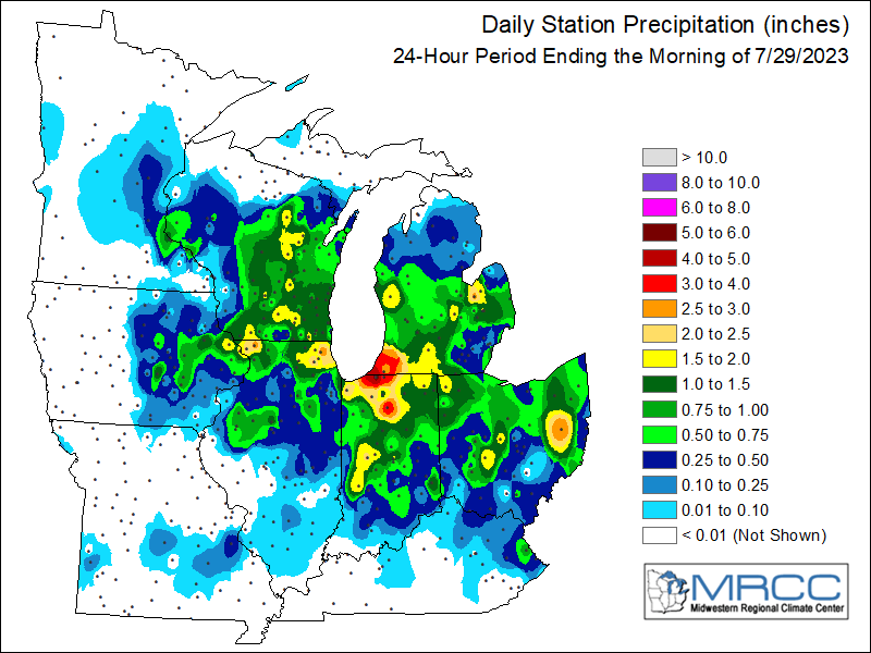
Rain Reports
| Local Rainfall Map | MRCC Regional Rainfall Map |
 |
 |
....IOWA....
Dubuque Arpt                     2.53
Dubuque #3 7 SW                  1.88
Dubuque 1.0 SE                   1.51
Bellevue LD12                    1.50
Manchester                       1.43
Grinnell AWOS 2 SSW              1.41
Robins 0.8 SE                    1.14
Vinton 3.6 SE                    1.01
Dubuque LD11                     1.00
Vinton                           0.95
Peosta 2.9 E                     0.91
Cedar Rapids Arpt                0.86
North English                    0.86
Parnell 0.1 SSW                  0.85
Charlotte 1.9 WNW                0.77
Center Point 0.6 NNW             0.77
North Liberty 0.7 SSW            0.76
Williamsburg 0.6 SW              0.73
Maquoketa                        0.66
Dubuque 1.4 WNW                  0.64
Asbury 0.4 SW                    0.64
Camanche 1.2 W                   0.61
Dundee 1.4 NNE                   0.60
De Witt                          0.60
Marion 0.4 NNW                   0.59
Cedar Rapids 2.1 NW              0.58
Pella AWOS 2 WSW                 0.53
Marengo 3.6 N                    0.49
Solon 0.3 ESE                    0.48
Amana 4.7 W                      0.48
Fayette 1 NW                     0.48
Anamosa 3 SSW                    0.48
Wellman 4.0 E                    0.46
Oelwein AWOS                     0.46
Solon 0.4 WNW                    0.44
Hampton 1 N                      0.43
Monticello 1 E                   0.43
Belle Plaine                     0.42
Ely 2.0 N                        0.38
Ottumwa ASOS 6 NNW               0.38
Marshalltown ASOS 4 N            0.35
West Branch 2.3 SSW              0.32
Dyersville 1.7 ESE               0.32
Lowden                           0.32
Eldridge 5.4 E                   0.31
Waterloo ASOS 5 NW               0.31
Guttenberg Dam 10                0.30
Lisbon 0.1 W                     0.28
Muscatine 2.6 NNE                0.27
Wapello 5.4 SE                   0.26
Muscatine 2.1 N                  0.26
Clarence 3.9 S                   0.26
Coralville 1.3 SE                0.26
Muscatine 1.4 N                  0.25
Farmington 3.5 W                 0.24
Muscatine 3.0 NE                 0.24
Muscatine 2N                     0.24
Farmington 2.4 W                 0.23
Burlington 0.8 SSE               0.23
Centerville 0 NE                 0.23
Farmington 0.3 NW                0.22
Mason City ASOS 6 W              0.22
Iowa City Arpt                   0.22
Davenport Arpt                   0.22
Farmington 0.4 NNW               0.21
Fairfield                        0.21
Davenport 0.9 WNW                0.20
Tipton 0.3 ESE                   0.20
Rathbun Reservoir 2 N            0.20
Sigourney                        0.20
Morning Sun 1.7 E                0.18
Burlington Arpt                  0.18
Yarmouth 1.9 SW                  0.15
Davenport 2.1 N                  0.15
Iowa City                        0.15
Iowa City 2.3 E                  0.14
Marshalltown 1 NW                0.14
Washington                       0.14
Oskaloosa AWOS 9 ESE             0.12
Burlington 6.5 SSW               0.11
Holy Cross 1.8 E                 0.11
Elkader 6SSW                     0.10
Mason City 1 NNE                 0.10
Donnellson                       0.10
Fairfield 5.7 NNE                0.09
Hillsboro 5.8 SE                 0.03
Wapello 0.2 S                    0.03
Strawberry Point                 0.03
Salem 1S                         0.00
Fort Madison 0.9 NE              0.00
Perry 0 W                        0.00
NWS Johnston* 5 NNW              0.00
Keokuk LD19                      0.00
Boone 1 SSW                      0.00
....ILLINOIS....
Mundelein                        2.74
Stockton 3.4 NNE                 2.58
Stockton 3 NNE                   2.58
Stockton 4.6 NW                  2.41
East Dubuque 1.7 SE              2.35
Elizabeth                        2.24
Hanover 0.2 NW                   2.15
Stockton 5.9 WNW                 2.13
Lena 0.3 SSE                     1.80
East Dubuque 1.7 ENE             1.75
Mount Carroll 6.8 NNW            1.62
Lanark 4.2 NNW                   1.61
                                 1.50
Lanark 5.3 N                     1.49
Freeport 2.9 WSW                 1.04
Winslow 4.3 ESE                  1.00
Rock Falls 3.1 S                 0.98
Freeport                         0.98
Rockford Arpt                    0.96
Galesburg                        0.86
Sterling 5.9 NNE                 0.78
Monmouth 0.4 SE                  0.64
Peoria Arpt                      0.59
Fulton LD13                      0.50
Ogden                            0.46
Quad City Arpt                   0.46
Prophetstown 0.2 SW              0.45
Coal Valley 2.6 E                0.41
Coal Valley 1.9 SE               0.40
Gladstone LD18                   0.40
Streator 3 SE                    0.40
Ottawa 4 SW                      0.35
Romeoville                       0.35
Kewanee 1 E                      0.35
Galva 0.9 SE                     0.34
Mendota 2 SE                     0.33
Tuscola                          0.30
Dallas City 3.0 SSE              0.27
St Anne                          0.25
Lincoln NWS                      0.25
Bloomington Airport              0.23
McNabb 1.4 NW                    0.22
Ill. City LD16 3 WNW             0.21
La Harpe                         0.20
Princeton 1.1 SE                 0.18
Princeton                        0.18
Stronghurst 0.4 SSW              0.17
Steward                          0.15
Rochelle Arpt                    0.14
Decatur Airport                  0.09
Illinois City 6.7 SW             0.08
New Windsor 2.0 N                0.05
Colchester 3.5 NE                0.04
Aledo                            0.03
Windsor                          0.02
Augusta                          0.00
New Boston LD17                  0.00
Quincy Arpt                      0.00
Jacksonville Arpt                0.00
....MISSOURI....
Columbia Arpt                    0.00
Chillicothe Arpt                 0.00
Kirksville Arpt                  0.00
Memphis                          0.00
....WISCONSIN....
Darlington                       1.60
Madison Arpt                     1.51
Beloit-College                   1.31
Sullivan-NWS 2 SE                1.25
Allenton-WWTP .6 NW              0.92
Delavan-1 W-WWTP 1 W             0.65
Monroe 1 W                       0.59
Brodhead 1 SW                    0.45
Prairie du Chien AWOS            0.38
Steuben 4SE 3 NE                 0.25
La Crosse WFO                    0.03
Viroqua                          0.00
....MINNESOTA....
Theilman 1SSW                    0.00
|
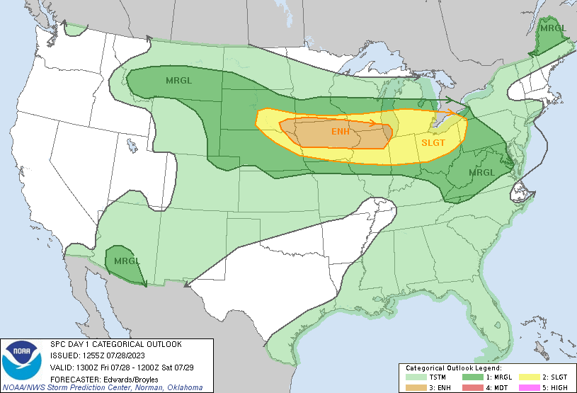
Environment
SPC Severe Weather Event Page July 28th, 2023
 |
 |
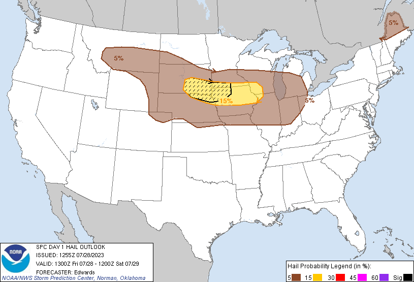 |
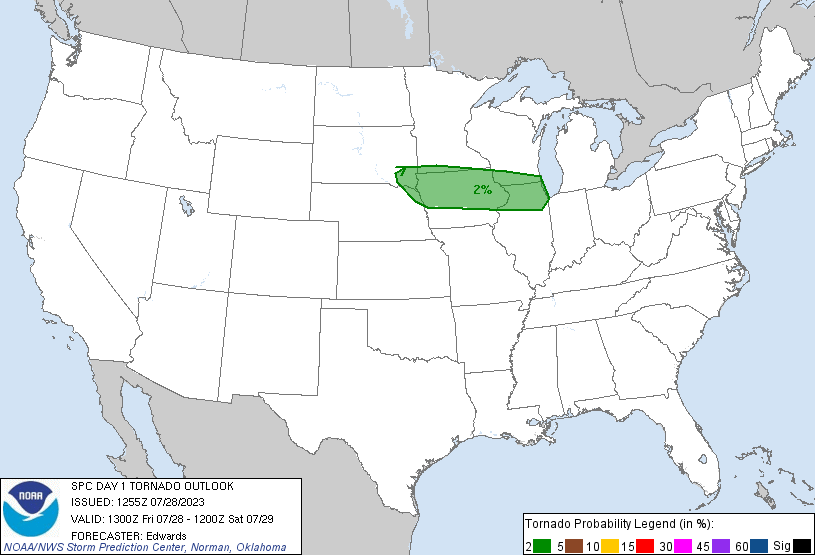
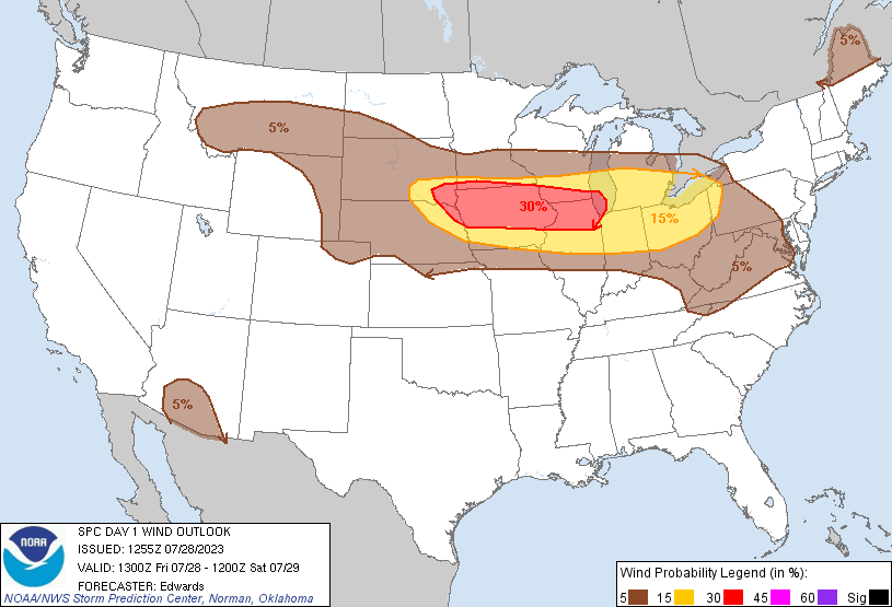
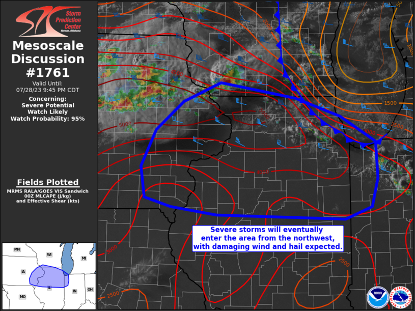
| Figure 1: SPC 1300z Day 1 Outlook | Figure 2: SPC 1300z Day 1 Tornado | Figure 3: SPC 1300z Day 1 Hail |
 |
 |
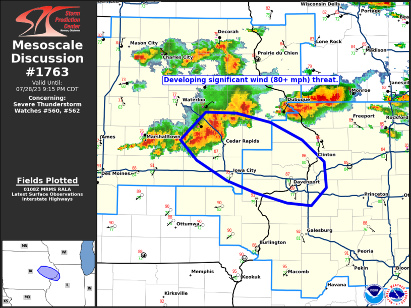 |
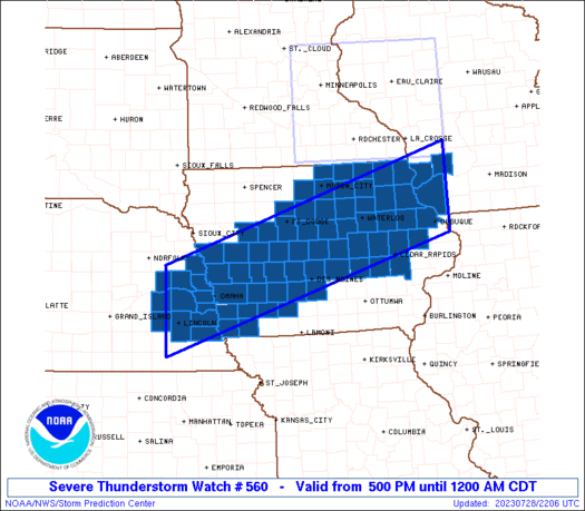
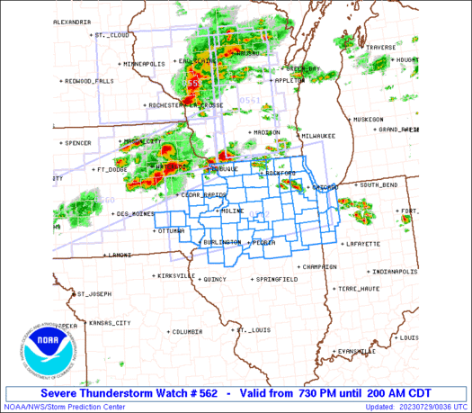
| Figure 4: SPC 1300z Day 1 Wind | Figure 5: Mesoscale Discussion #1761 | Figure 6: Mesoscale Discussion #1763 |
 |
 |
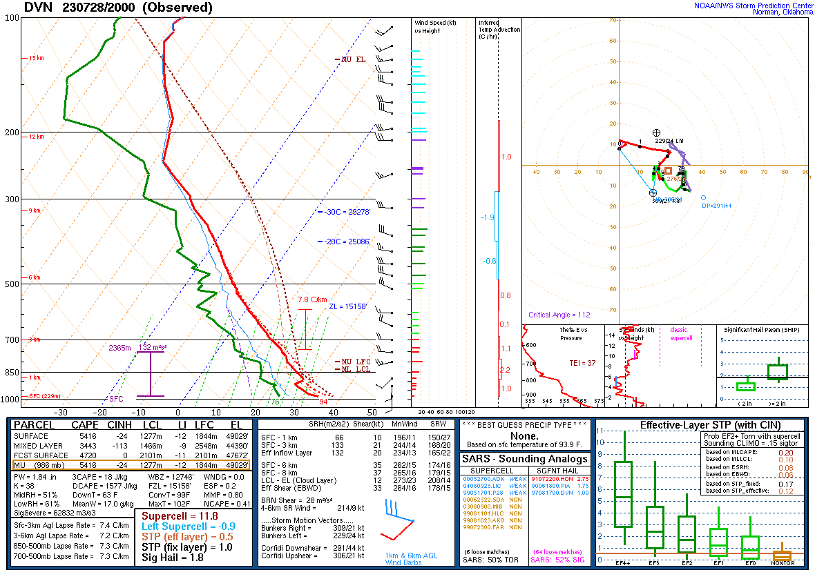 |
| Figure 7: Severe Thunderstorm Area | Figure 8: Severe Thunderstorm Area | Figure 9: 20z DVN Sounding |
 |
||
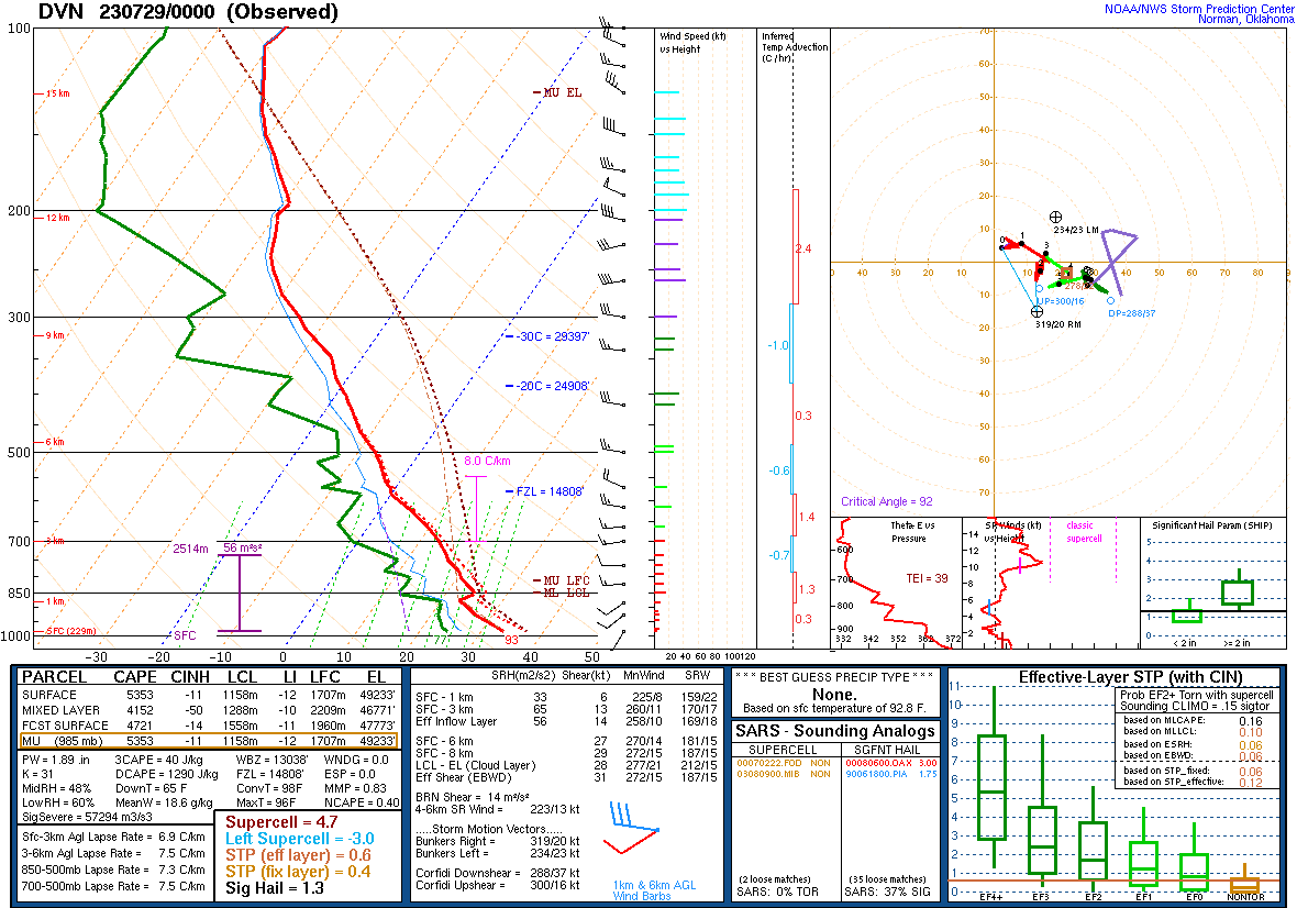
| Figure 10: 00z DVN Sounding |
 |
Media use of NWS Web News Stories is encouraged! Please acknowledge the NWS as the source of any news information accessed from this site. |
|