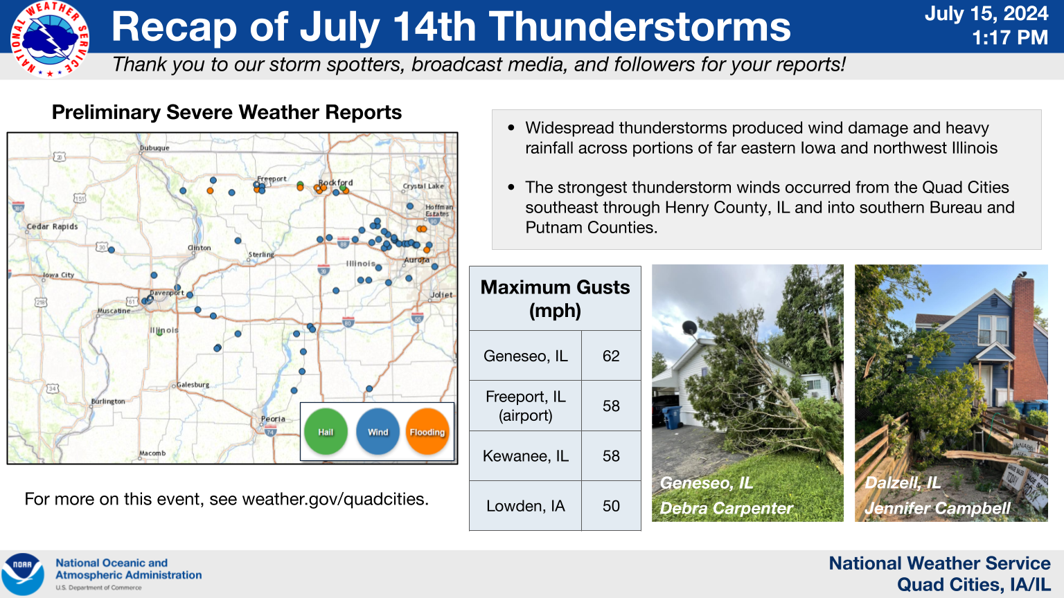
Storm Reports...Summary
Preliminary Local Storm Report...Summary
National Weather Service Quad Cities IA IL
108 PM CDT Mon Jul 15 2024

..TIME...   ...EVENT...      ...CITY LOCATION...     ...LAT.LON...
..DATE...   ....MAG....      ..COUNTY LOCATION..ST.. ...SOURCE....
            ..REMARKS..

0716 PM     Tstm Wnd Dmg     Hanover                 42.25N 90.28W
07/14/2024                   Jo Daviess         IL   Law Enforcement

            Corrects previous tstm wnd dmg report from
            Hanover. Tree down in Hanover. Time
            estimated from radar data.

0740 PM     Tstm Wnd Dmg     2 NW Plum River         42.32N 90.01W
07/14/2024                   Jo Daviess         IL   Law Enforcement

            Trees down a few miles south of Stockton.
            Times estimated from radar data.

0815 PM     Tstm Wnd Gst     Freeport                42.29N 89.63W
07/14/2024  E50 MPH          Stephenson         IL   Trained Spotter

            Estimated 50 MPH wind gust.

0815 PM     Tstm Wnd Gst     Freeport Albertus       42.25N 89.58W
07/14/2024  M58 MPH          Stephenson         IL   AWOS

            AWOS at the Freeport Airport measured a gust
            of 58 mph.

0815 PM     Tstm Wnd Dmg     2 N Freeport Albertus   42.28N 89.58W
07/14/2024                   Stephenson         IL   Law Enforcement

            Tree limbs down.

0825 PM     Tstm Wnd Dmg     2 SSW Pearl City        42.24N 89.85W
07/14/2024                   Stephenson         IL   Law Enforcement

            Tree limbs blown down.

0839 PM     Tstm Wnd Dmg     1 NNE Coleta            41.92N 89.79W
07/14/2024                   Whiteside          IL   Storm Chaser

            Tree limb damage. Possible Tornado 839 pm to
            843 pm in this area.

0843 PM     Flash Flood      2 SE Freeport           42.26N 89.62W
07/14/2024                   Stephenson         IL   Public

            Report from mPING: Street/road flooding;
            Street/road closed; Vehicles stranded.

0921 PM     Hail             1 SE Sherrard           41.31N 90.49W
07/14/2024  M0.75 Inch       Mercer             IL   Public

            Report from mPING: Dime (0.75 in.).

0950 PM     Rain             2 W Bolton              42.26N 89.77W
07/14/2024  M1.80 Inch       Stephenson         IL   Trained Spotter

            Delayed report.

0958 PM     Rain             3 N Stockton            42.40N 90.00W
07/14/2024  M1.29 Inch       Jo Daviess         IL   CO-OP Observer


1003 PM     Tstm Wnd Gst     Lowden                  41.86N 90.92W
07/14/2024  E50 MPH          Cedar              IA   CO-OP Observer

            1/2 half inch rain in 10 minutes.

1021 PM     Tstm Wnd Dmg     Park View               41.69N 90.54W
07/14/2024                   Scott              IA   NWS Employee

            Delayed report and time estimated from
            radar. Several 2-3 inch diameter branches
            down. Vehicle damaged.

1035 PM     Tstm Wnd Dmg     2 SE Davenport          41.54N 90.57W
07/14/2024                   Scott              IA   Law Enforcement

            1500 block of Iowa Street. Tree down on
            powerline.

1035 PM     Tstm Wnd Dmg     3 SE Davenport          41.53N 90.57W
07/14/2024                   Scott              IA   Law Enforcement

            Trees blown down at 7th and Iowa St.

1035 PM     Tstm Wnd Dmg     1 N Credit Island       41.52N 90.62W
07/14/2024                   Scott              IA   Law Enforcement

            Tree blown down.

1035 PM     Tstm Wnd Dmg     2 NE Credit Island      41.52N 90.59W
07/14/2024                   Scott              IA   Law Enforcement

            1400 block of west 3rd street. Tree blown
            down.

1036 PM     Tstm Wnd Dmg     1 SSW Port Byron        41.61N 90.33W
07/14/2024                   Rock Island        IL   Trained Spotter

            Delayed report and time estimated from
            radar. Large tree down across residential
            street.

1046 PM     Tstm Wnd Dmg     4 NE Osborn             41.56N 90.22W
07/14/2024                   Rock Island        IL   Public

            Several small tree branches down approx. 3-4
            inch in diameter reported via social media.
            Time estimated from radar.

1054 PM     Tstm Wnd Gst     1 NNE Geneseo           41.46N 90.15W
07/14/2024  M62 MPH          Henry              IL   Mesonet

            Measured at Bob Reade Field on the north
            side of Geneseo.

1100 PM     Flash Flood      1 SE Elmoville          42.25N 90.04W
07/14/2024                   Jo Daviess         IL   Law Enforcement

            Bethel and East Rush Roads closed due to
            flash flooding. Water also affecting Highway
            78.

1100 PM     Tstm Wnd Dmg     Atkinson                41.42N 90.01W
07/14/2024                   Henry              IL   Newspaper

            tree limb down on powerlines. Time of the
            event estimated using radar.

1100 PM     Flash Flood      1 SSE Elmoville         42.25N 90.04W
07/14/2024                   Jo Daviess         IL   Law Enforcement

            Bethel and East Rush Roads closed do flash
            flooding. Water affecting Illinois Highway
            78 as well.

1100 PM     Flash Flood      1 SE Elmoville          42.25N 90.04W
07/14/2024                   Jo Daviess         IL   Law Enforcement

            Bethel and East Rush roads closed due to
            flash flooding. Affecting Illinois Highway
            78.

1115 PM     Tstm Wnd Dmg     Neponset                41.30N 89.79W
07/14/2024                   Bureau             IL   Law Enforcement

            powerpoles and a tree down near Neponset.
            Time of the event estimated using radar.

1119 PM     Tstm Wnd Gst     3 SW Kewanee            41.21N 89.97W
07/14/2024  M58 MPH          Henry              IL   Mesonet

            Measured at the Kewanee Airport. (KEZI).

1122 PM     Tstm Wnd Dmg     4 NE Galva              41.20N 89.98W
07/14/2024                   Henry              IL   Emergency Mngr

            Sheriff reported a tree blocking Midland
            Road near the country club. Time of the
            event estimated using radar.

1143 PM     Tstm Wnd Dmg     2 NE Moronts            41.30N 89.27W
07/14/2024                   Putnam             IL   Law Enforcement

            Couple trees downed in Wolf Hollow area.
            Time estimated using radar.

1150 PM     Tstm Wnd Dmg     Mc Nabb                 41.18N 89.21W
07/14/2024                   Putnam             IL   Law Enforcement

            Large branches of 1 foot plus downed.

1200 AM     Rain             2 WSW Loran             42.22N 89.95W
07/15/2024  M1.98 Inch       Jo Daviess         IL   Mesonet

            Evening rainfall total.

1200 AM     Rain             2 NNE Sterling          41.82N 89.67W
07/15/2024  M2.64 Inch       Whiteside          IL   Mesonet

            Evening rainfall total.

0552 AM     Rain             3 ENE Garden Plain      41.81N 90.08W
07/15/2024  M1.40 Inch       Whiteside          IL   Trained Spotter

            Rainfall total from Sunday.

0612 AM     Rain             1 SE Davenport          41.54N 90.59W
07/15/2024  M1.08 Inch       Scott              IA   Trained Spotter


0708 AM     Rain             1 NW Davenport          41.56N 90.62W
07/15/2024  M1.20 Inch       Scott              IA   Trained Spotter

            Storm total.

0739 AM     Rain             1 W Bettendorf          41.56N 90.49W
07/15/2024  M1.67 Inch       Scott              IA   Trained Spotter

            Storm total.

0819 AM     Rain             Preston                 42.05N 90.40W
07/15/2024  M2.05 Inch       Jackson            IA   Public

            24 hour total.

0848 AM     Rain             2 SSE Warner            41.39N 90.37W
07/15/2024  M1.48 Inch       Henry              IL   Trained Spotter

            24 hour total.

1009 AM     Rain             1 SSW Cordova           41.67N 90.33W
07/15/2024  M1.80 Inch       Rock Island        IL   Trained Spotter

            24 hour total.
Media use of NWS Web News Stories is encouraged!
Please acknowledge the NWS as the source of any news information accessed from this site.
Our past events page can be found at weather.gov/dvn/events.